Grade II* listed buildings in Great Yarmouth
There are over 20,000 Grade II* listed buildings in England. This page is a list of these buildings in the district of Great Yarmouth in Norfolk.
Great Yarmouth
| Name | Location | Type | Completed [note 1] | Date designated | Grid ref.[note 2] Geo-coordinates |
Entry number [note 3] | Image |
|---|---|---|---|---|---|---|---|
| Wiseman's Mill | Ashby with Oby, Great Yarmouth | Drainage Mill | Built 1753 | 4 December 1987 | TG4092613793 52°40′06″N 1°33′43″E |
1051014 | 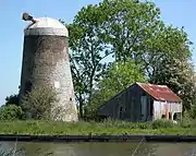 Wiseman's Mill |
| Belton Old Hall | Belton with Browston | House | Early 18th century | 27 November 1954 | TG4828802623 52°33′53″N 1°39′43″E |
1372933 |  |
| Browston Hall Hotel | Browston Green, Belton with Browston | House | Late 17th century | 27 November 1954 | TG4997401772 52°33′23″N 1°41′11″E |
1051001 | 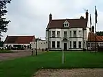 Browston Hall Hotel |
| Church of All Saints | Belton with Browston | Parish Church | 1866 | 27 November 1954 | TG4855502949 52°34′03″N 1°39′59″E |
1372932 | 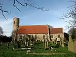 Church of All Saints |
| Church of St Nicholas | Bradwell | Parish Church | 12th century | 27 November 1954 | TG5031503855 52°34′29″N 1°41′34″E |
1051006 | 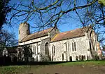 Church of St Nicholas |
| Church of St Peter and St Paul | Burgh Castle | Parish Church | Late 11th century | 27 November 1954 | TG4764004973 52°35′10″N 1°39′15″E |
1051008 | 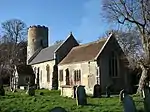 Church of St Peter and St Paul |
| Church of Holy Trinity | Caister-on-Sea | Parish Church | 13th century | 4 March 1947 | TG5199612278 52°38′59″N 1°43′26″E |
1287563 | 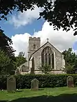 Church of Holy Trinity |
| Church of All Saints | Filby | Parish Church | 14th century | 25 September 1962 | TG4690113224 52°39′38″N 1°38′58″E |
1287564 | 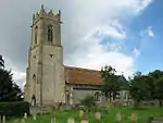 Church of All Saints |
| Church of St Margaret | Burgh St Margaret, Fleggburgh | Parish Church | 12th century | 25 September 1962 | TG4449414010 52°40′07″N 1°36′53″E |
1372907 | 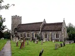 Church of St Margaret |
| Church of St Peter | Clippesby, Fleggburgh | Parish Church | c. 1200 | 25 September 1962 | TG4284614588 52°40′28″N 1°35′27″E |
1051017 | 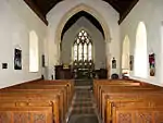 Church of St Peter |
| Church of St Edmund | Fritton and St. Olaves | Parish Church | 12th century | 27 November 1954 | TG4732700143 52°32′35″N 1°38′46″E |
1372918 | 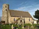 Church of St Edmund |
| Drainage Pump | St Olave's Marsh, Fritton and St. Olaves | Drainage Mill | 1910 | 27 November 1954 | TM4568499713 52°32′23″N 1°37′18″E |
1372904 | 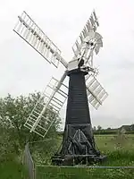 Drainage Pump |
| Fritton Old Hall | Fritton and St. Olaves | House/Restaurant | c. 1540 | 27 November 1954 | TG4760300145 52°32′34″N 1°39′01″E |
1305105 | 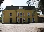 Fritton Old Hall |
| Barn at Home Farm | Hemsby | Aisled Barn | Early 17th century | 4 March 1947 | TG4915917271 52°41′45″N 1°41′09″E |
1287567 | |
| Church of St Margaret | Hopton-on-Sea | Parish Church | 1866-67 | 27 November 1954 | TG5241500040 52°32′23″N 1°43′15″E |
1050972 | 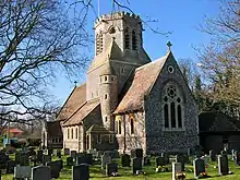 Church of St Margaret |
| Old St Margaret's Church | Hopton-on-Sea | Parish Church (ruined) | Late 13th century | 27 November 1954 | TM5301799972 52°32′20″N 1°43′47″E |
1050970 | 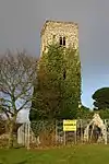 Old St Margaret's Church |
| Church of St Mary | Thrigby, Mautby | Parish Church | First half 14th century | 25 September 1962 | TG4605312393 52°39′12″N 1°38′11″E |
1152375 | 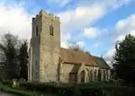 Church of St Mary |
| Church of St Peter and St Paul | Runham, Mautby | Church | Mid 14th century | 25 September 1962 | TG4597410827 52°38′22″N 1°38′03″E |
1050977 | 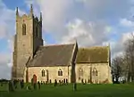 Church of St Peter and St Paul |
| Church of St Peter and St Paul | Mautby | Parish Church | Late 12th century | 25 September 1962 | TG4807012377 52°39′08″N 1°39′58″E |
1152350 | 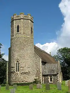 Church of St Peter and St Paul |
| Church of St Margaret | Ormesby St. Margaret with Scratby | Parish Church | 14th century | 25 September 1962 | TG4988714532 52°40′15″N 1°41′41″E |
1227867 | 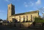 Church of St Margaret |
| Ormesby Old Hall | Ormesby St. Margaret with Scratby | House | Mid 17th century | 20 February 1952 | TG5003814501 52°40′14″N 1°41′49″E |
1287569 | .jpg.webp) Ormesby Old Hall |
| Church of St Michael | Ormesby St. Michael | Parish Church | 13th century | 25 September 1962 | TG4807514883 52°40′29″N 1°40′05″E |
1287570 | 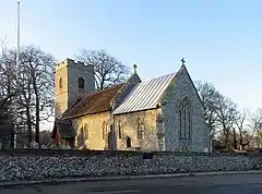 Church of St Michael |
| Church of St Peter and St Paul | Repps with Bastwick | Parish Church | 12th century | 25 September 1962 | TG4219016927 52°41′45″N 1°34′58″E |
1051024 | 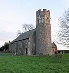 Church of St Peter and St Paul |
| Potter Heigham Bridge | Repps with Bastwick | Road Bridge | 14th century | 16 April 1955 | TG4199818473 52°42′35″N 1°34′52″E |
1305009 | 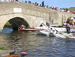 Potter Heigham Bridge |
| Church of St George | Rollesby | Parish Church | 12th century | 25 September 1962 | TG4461915759 52°41′03″N 1°37′04″E |
1152526 | 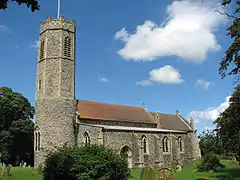 Church of St George |
| Burnley Hall | East Somerton, Somerton | House | Early 18th century | 20 February 1952 | TG4787819756 52°43′07″N 1°40′08″E |
1216607 | 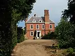 Burnley Hall |
| Church of St Mary | West Somerton, Somerton | Parish Church | c. 1200 | 25 September 1962 | TG4754919547 52°43′01″N 1°39′50″E |
1216608 |  Church of St Mary |
| Church of St Andrew | Stokesby with Herringby | Parish Church | 13th century | 25 September 1962 | TG4359210568 52°38′17″N 1°35′56″E |
1152707 | 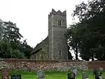 Church of St Andrew |
| Church of St Edmund | Thurne | Parish Church | Late 13th century | 25 September 1962 | TG4051015613 52°41′05″N 1°33′25″E |
1304567 | 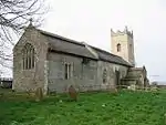 Church of St Edmund |
| Thurne Dyke Windpump | Thurne | Drainage Mill | 1820 | 7 December 1962 | TG4005315918 52°41′16″N 1°33′02″E |
1050999 | 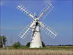 Thurne Dyke Windpump |
| Caister Hall | West Caister | Castle | 19th century | 4 December 1987 | TG5042012218 52°38′59″N 1°42′03″E |
1228031 | 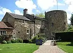 Caister Hall |
| Church of St Andrew | Southtown and Gorleston | Parish Church | 13th century | 27 June 1953 | TG5244704408 52°34′44″N 1°43′29″E |
1096807 | .jpg.webp) Church of St Andrew |
| Church of St Mary including Church Rooms and Surrounding Wall | Regent Rd, Great Yarmouth | Roman Catholic Church | 1848-1850 | 9 December 1976 | TG5289607634 52°36′27″N 1°44′01″E |
1245910 | |
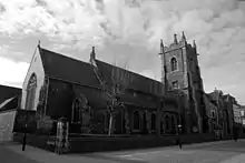
| Church of St Nicholas | Great Yarmouth | Parish Church | 1101-1119 | 27 June 1953 | TG5243508036 52°36′41″N 1°43′38″E |
1096813 | 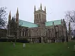 Church of St Nicholas |
| Church of St Peter | Southtown and Gorleston | Catholic Church | 1938-1939 | 5 August 1974 | TG5262904123 52°34′34″N 1°43′38″E |
1246581 |  Church of St Peter |
| Custom House | Great Yarmouth | Merchants House | 1720 | 5 August 1974 | TG5240607236 52°36′15″N 1°43′34″E |
1245800 | .jpg.webp) Custom House |
| Great Yarmouth Potteries | Great Yarmouth | Fish curing works | 19th century | 9 December 1976 | TG5272706909 52°36′04″N 1°43′50″E |
1245561 | 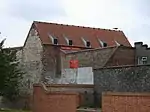 Great Yarmouth Potteries |
| Old Merchants House | Great Yarmouth | Merchants House | Early 17th century | 27 June 1953 | TG5246207142 52°36′12″N 1°43′37″E |
1245917 | 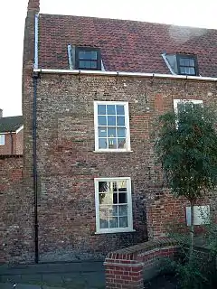 Old Merchants House |
| Old White Lion Public House | Great Yarmouth | Public House | Early 17th century | 27 June 1953 | TG5263507081 52°36′10″N 1°43′46″E |
1271278 | 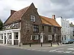 Old White Lion Public House |
| St Nicholas Hospital Main Block | Great Yarmouth | Hospital | 1818 | 5 August 1974 | TG5289006400 52°35′47″N 1°43′58″E |
1245983 | |
| St Nicholas Hospital Main Entrance Range | Great Yarmouth | Entrance | 1811 | 5 August 1974 | TG5284006464 52°35′50″N 1°43′55″E |
1245984 | |
| The Hippodrome | Great Yarmouth | Circus (recreational) | 1903 | 8 December 1978 | TG5304807119 52°36′10″N 1°44′08″E |
1245922 | |
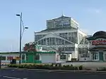
| The Winter Gardens | Great Yarmouth | Glasshouse | 1878-1881 | 5 August 1974 | TG5314806762 52°35′59″N 1°44′12″E |
1271608 | |
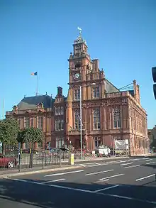
| Town Hall | Great Yarmouth | Magistrates Court | Until 1990 | 5 August 1974 | TG5231307426 52°36′21″N 1°43′30″E |
1246969 | |
| Vicarage | Great Yarmouth | Vicarage | Early 17th century | 27 June 1953 | TG5243907977 52°36′39″N 1°43′38″E |
1096809 | |
| 25 South Quay | Great Yarmouth | House | 1644 | 27 June 1953 | TG5243807190 52°36′14″N 1°43′36″E |
1245803 | 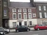 25 South Quay |
.jpg.webp)
Notes
- The date given is the date used by Historic England as significant for the initial building or that of an important part in the structure's description.
- Sometimes known as OSGB36, the grid reference is based on the British national grid reference system used by the Ordnance Survey.
- The "List Entry Number" is a unique number assigned to each listed building and scheduled monument by Historic England.
External links
![]() Media related to Grade II* listed buildings in Norfolk, England at Wikimedia Commons
Media related to Grade II* listed buildings in Norfolk, England at Wikimedia Commons
This article is issued from Wikipedia. The text is licensed under Creative Commons - Attribution - Sharealike. Additional terms may apply for the media files.
