Grade II* listed buildings in Lewes (district)
There are over 20,000 Grade II* listed buildings in England. This page is a list of these buildings in the district of Lewes in East Sussex.

Lewes shown within East Sussex
Lewes
| Name | Location | Type | Completed [note 1] | Date designated | Grid ref.[note 2] Geo-coordinates |
Entry number [note 3] | Image |
|---|---|---|---|---|---|---|---|
| The Parish Church of St Mary | Barcombe, Lewes | Church | 1100 circa | 20 August 1965 | TQ4187014309 50°54′39″N 0°01′00″E |
1043993 | 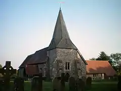 The Parish Church of St Mary |
| Itford Farmhouse | Itford, Beddingham, Lewes | House | Medieval | 20 August 1965 | TQ4332805498 50°49′53″N 0°02′02″E |
1352945 | 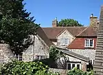 Itford Farmhouse |
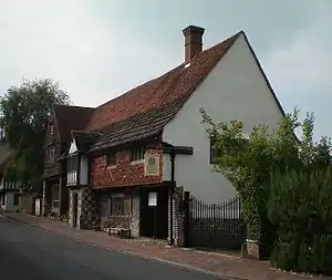
| 1 Coppard's Bridge | Chailey, Lewes | Timber Framed House | Built c1475 | 27 September 1979 | TQ4001319559 50°57′30″N 0°00′28″W |
1043978 | 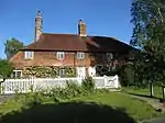 1 Coppard's Bridge |
| The Parish Church of St Peter | Chailey Green, Chailey, Lewes | Church | 13th century | 20 August 1965 | TQ3922019339 50°57′24″N 0°01′09″W |
1352947 | 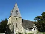 The Parish Church of St Peter |
| Wapsbourne | Sheffield Park, Chailey, Lewes | Timber Framed House | Early 17th century | 17 March 1952 | TQ3996123405 50°59′35″N 0°00′25″W |
1352974 |  |
| Cotterlings | Ditchling, Lewes | House | Refronted 1790 | 20 August 1965 | TQ3245415221 50°55′17″N 0°07′01″W |
1275640 | .JPG.webp) Cotterlings |
| Chapel Farmhouse | East Chiltington, Lewes | Farmhouse | 16th century | 17 March 1952 | TQ3686315094 50°55′09″N 0°03′15″W |
1275609 | 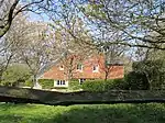 Chapel Farmhouse |
| The Parish Church | East Chiltington, Lewes | Anglican Church | 12th century | 20 August 1965 | TQ3699015125 50°55′10″N 0°03′09″W |
1043970 | 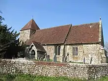 The Parish Church |
| Barn to the East of Court Farmhouse | Falmer, Lewes | Barn | 16th century | 17 March 1952 | TQ3555808778 50°51′45″N 0°04′31″W |
1275514 | |
| The Parish Church of St Laurence | Falmer, Lewes | Anglican Church | 1817 | 20 August 1965 | TQ3549108744 50°51′44″N 0°04′34″W |
1352989 | 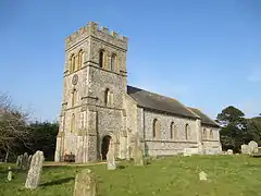 The Parish Church of St Laurence |
| Charleston | Firle, Lewes | House | 18th century | 20 August 1965 | TQ4903606926 50°50′34″N 0°06′56″E |
1043946 | |
| Stables of Firle Place to West of the House & Firle Place Riding School | Firle, Lewes | Gate | Late 18th century or early 19th century | 17 March 1952 | TQ4720307111 50°50′41″N 0°05′22″E |
1275469 |  Stables of Firle Place to West of the House & Firle Place Riding School |
| The Garden Wall with Carriage Entrance, South East of Glynde Place | Glynde, Lewes | Gate | Between 1755 and 1760 | 20 August 1965 | TQ4566709309 50°51′54″N 0°04′07″E |
1043919 | 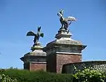 The Garden Wall with Carriage Entrance, South East of Glynde Place |
| The Parish Church of St Mary the Virgin | Glynde, Lewes | Anglican Church | 1763-5 | 20 August 1965 | TQ4564709267 50°51′52″N 0°04′06″E |
1043918 | |
| Coombe Place | Offham, Hamsey, Lewes | Farmhouse | 1657 | 17 March 1952 | TQ3932012317 50°53′37″N 0°01′13″W |
1221911 | |
| Hamsey House Cottage Yeomans | Hamsey, Lewes | House | 19th century | 20 August 1965 | TQ4111112559 50°53′43″N 0°00′19″E |
1222113 | |
| Hamsey Place Farmhouse | Hamsey, Lewes | Farmhouse | 16th century | 17 March 1952 | TQ4117712248 50°53′33″N 0°00′21″E |
1274819 | |
| Offham House | Offham, Hamsey, Lewes | House | Possibly 1676 | 17 March 1952 | TQ3988812374 50°53′38″N 0°00′44″W |
1221909 | |
| Iford Grange and Stables adjoining to North West | Iford, Lewes | House | Early 19th century | 20 August 1965 | TQ4063407268 50°50′52″N 0°00′13″W |
1274761 | |
| The Parish Church of St Pancras | Kingston near Lewes, Lewes | Church | Early 14th century | 20 August 1965 | TQ3914408167 50°51′23″N 0°01′28″W |
1222327 | 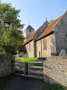 The Parish Church of St Pancras |
| All Saints' Community Centre | Lewes | Former parish church | Early 16th century | 25 February 1952 | TQ4175810024 50°52′20″N 0°00′48″E |
1191009 | .jpg.webp) All Saints' Community Centre |
| Anne of Cleves House | Southover, Lewes, Lewes | House | Late 15th century or early 16th century | 25 February 1952 | TQ4111309633 50°52′08″N 0°00′15″E |
1043733 | |
| Barbican House | Lewes | House | Later 16th century | 25 February 1952 | TQ4140710042 50°52′21″N 0°00′30″E |
1043818 | |
| Bull House | Lewes | House | 16th century | 25 February 1952 | TQ4129009967 50°52′19″N 0°00′24″E |
1191309 | 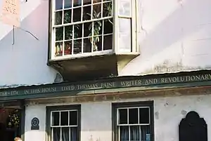 Bull House |
| Castle Place Nos 165 and 167, and Railings | Lewes | Row House | 1810 | 25 February 1952 | TQ4137810026 50°52′21″N 0°00′29″E |
1353051 | |
| Church of St Thomas at Cliffe | Cliffe, Lewes | Church | 12th century | 25 February 1952 | TQ4213210272 50°52′28″N 0°01′08″E |
1043870 | 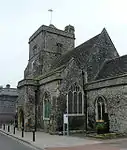 Church of St Thomas at Cliffe |
| Crown Hotel | Lewes | Hotel | Late 18th century | 25 February 1952 | TQ4158410164 50°52′25″N 0°00′39″E |
1191714 | 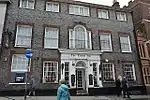 Crown Hotel |
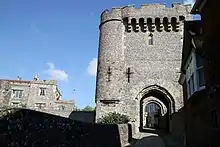
| Harveys Brewery | Cliffe, Lewes | Tower | Early 19th century | 29 October 1985 | TQ4197810289 50°52′29″N 0°01′00″E |
1043864 | |
| Lamb House | Cliffe, Lewes | House | Mid 18th century | 25 March 1952 | TQ4220510271 50°52′28″N 0°01′11″E |
1190338 | |
| Law Courts | Lewes | County Hall | 1808-1812 | 25 February 1952 | TQ4150210114 50°52′24″N 0°00′35″E |
1043780 | 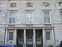 Law Courts |
| Lewes House | Lewes | House | Early 18th century | 25 February 1952 | TQ4166310147 50°52′24″N 0°00′43″E |
1353052 | 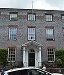 Lewes House |
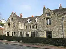
| Malling Deanery | Malling, Lewes | House | Possibly earlier | 25 February 1952 | TQ4130710938 50°52′50″N 0°00′26″E |
1353012 |  Malling Deanery |
| No 111 High Street and Railings to North | Lewes | House | Early 18th century | 25 February 1952 | TQ4110709969 50°52′19″N 0°00′15″E |
1043804 | 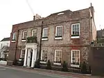 No 111 High Street and Railings to North |
| Pelham House and Wall to South | Lewes | House | 16th century | 25 February 1952 | TQ4147810005 50°52′20″N 0°00′34″E |
1043747 | |
| School Hill House | Lewes | House | Late 17th century | 25 February 1952 | TQ4164610141 50°52′24″N 0°00′43″E |
1043822 | |
| Shelley's Hotel and Railings to South | Lewes | House | 16th century | 25 February 1952 | TQ4110110004 50°52′20″N 0°00′14″E |
1191443 | 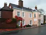 Shelley's Hotel and Railings to South |
| Southover Grange | Lewes | House | 1572 | 25 February 1952 | 49°46′01″N 7°33′26″W | 1192300 | |
| St Swithun House | Lewes | House | Early 18th century | 25 February 1952 | TQ4136209995 50°52′20″N 0°00′28″E |
1043837 | |
| The Caprons and Railings to West | Lewes | House | Early to mid 18th century | 25 February 1952 | TQ4130609857 50°52′15″N 0°00′25″E |
1286853 | |
| Tyne House and Railings to South | Lewes | House | c. 1720 | 25 February 1952 | TQ4118809999 50°52′20″N 0°00′19″E |
1191493 | 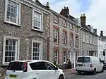 Tyne House and Railings to South |
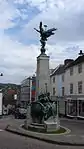
| War Memorial | Lewes | War Memorial | 1922 | 27 October 2014 | TQ4159610140 50°52′24″N 0°00′40″E |
1191738 | |
| Westgate Chapel | Lewes | Chapel | 1583 | 25 February 1952 | TQ4129309954 50°52′19″N 0°00′24″E |
1043839 | .jpg.webp) Westgate Chapel |
| Church of St Leonard | Denton, Newhaven, Lewes | Bell Tower | Possibly earlier-Pre 13th century | 20 May 1949 | TQ4545102580 50°48′16″N 0°03′46″E |
1197491 | 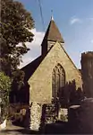 Church of St Leonard |
| Church of St Michael and All Angels | Newhaven, Lewes | Parish Church | Norman | 20 May 1949 | TQ4426101128 50°47′30″N 0°02′43″E |
1206261 | 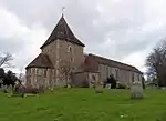 Church of St Michael and All Angels |
| Founthill Farm | Newick, Lewes | Farmhouse | Early 16th century | 17 March 1952 | TQ4209620264 50°57′51″N 0°01′20″E |
1238009 | |
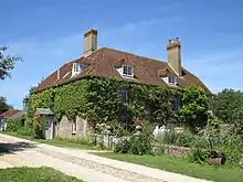
| Newick Park | Newick Park, Newick, Lewes | House | c. 1560 | 17 March 1952 | TQ4215219504 50°57′27″N 0°01′21″E |
1274385 | 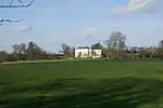 Newick Park |
| The Manor House | Newick, Lewes | Farmhouse | 17th century | 17 March 1952 | TQ4207220789 50°58′08″N 0°01′19″E |
1274449 | |
| The Parish Church of St Mary | Newick, Lewes | Church | 11th century | 20 August 1965 | TQ4216320824 50°58′09″N 0°01′24″E |
1237870 | 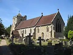 The Parish Church of St Mary |
| Plumpton Place | Plumpton, Lewes | House | 17th century | 17 March 1952 | TQ3604513453 50°54′16″N 0°03′59″W |
1274171 | 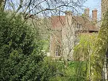 Plumpton Place |
| Upper Mill | Plumpton, Lewes | Mill House | 17th century or earlier | 20 August 1965 | TQ3629314746 50°54′58″N 0°03′45″W |
1238553 | |
| Little Manor | Ringmer, Lewes | House | Earlier | 17 March 1952 | TQ4451712317 50°53′32″N 0°03′12″E |
1238797 | 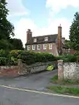 Little Manor |
| The Rectory | Rodmell, Lewes | House | Possibly 19th century | 27 September 1979 | TQ4201406173 50°50′16″N 0°00′56″E |
1273921 | |
| The Parish Church of St Peter | Seaford, Lewes | Parish Church | 13th century | 2 March 1950 | TV4839999819 50°46′44″N 0°06′13″E |
1044020 | .JPG.webp) The Parish Church of St Peter |
| Manor Farmhouse and the Garden Wall to North and West of the House | South Heighton, South Heighton, Lewes | Farmhouse | 18th century | 20 August 1965 | TQ4504902905 50°48′27″N 0°03′26″E |
1239546 | |
| Ashcombe House | Ashcombe House, St. Ann (Without), Lewes | Farmhouse | 18th century | 17 March 1952 | TQ3876109568 50°52′08″N 0°01′46″W |
1273885 | |
| Streat Place | Streat, Lewes | House | Between 1607 and 1627 | 20 August 1965 | TQ3505215229 50°55′15″N 0°04′48″W |
1239638 | 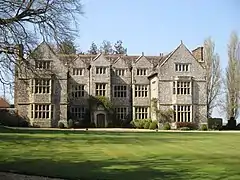 Streat Place |
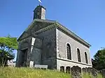
| The Parish Church | Streat, Lewes | Church | c. 1200 | 20 August 1965 | TQ3508515179 50°55′13″N 0°04′46″W |
1239635 | 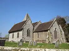 The Parish Church |
| The Parish Church of St Martin | Westmeston, Lewes | Church | 12th century | 20 August 1965 | TQ3388813639 50°54′24″N 0°05′50″W |
1222779 | 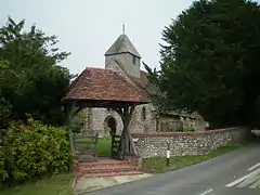 The Parish Church of St Martin |
| The Parish Church of St Peter and St John the Baptist | Wivelsfield, Lewes | Church | From Saxon to Perpendicular | 20 August 1965 | TQ3383920784 50°58′15″N 0°05′43″W |
1222972 | 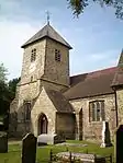 The Parish Church of St Peter and St John the Baptist |
| Theobalds | Burgess Hill, Wivelsfield, Lewes | House | 17th century or earlier | 17 March 1952 | TQ3258620633 50°58′12″N 0°06′47″W |
1223095 | |
| Ditchling War Memorial | Ditchling | War memorial | 1919 | 12 October 2016 | TQ3243515250 50°55′17″N 0°07′02″W |
1438295 | 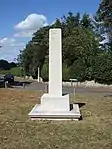 Ditchling War Memorial |
.jpg.webp)
Notes
- The date given is the date used by Historic England as significant for the initial building or that of an important part in the structure's description.
- Sometimes known as OSGB36, the grid reference is based on the British national grid reference system used by the Ordnance Survey.
- The "List Entry Number" is a unique number assigned to each listed building and scheduled monument by Historic England.
External links
![]() Media related to Grade II* listed buildings in East Sussex at Wikimedia Commons
Media related to Grade II* listed buildings in East Sussex at Wikimedia Commons
This article is issued from Wikipedia. The text is licensed under Creative Commons - Attribution - Sharealike. Additional terms may apply for the media files.