Grade II* listed buildings in Lichfield (district)
There are over 20,000 Grade II* listed buildings in England. This page is a list of these buildings in the district of Lichfield in Staffordshire.
Lichfield
| Name | Location | Type | Completed [note 1] | Date designated | Grid ref.[note 2] Geo-coordinates |
Entry number [note 3] | Image |
|---|---|---|---|---|---|---|---|
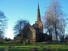
| Church of St John | Armitage with Handsacre, Lichfield | Parish Church | 1632 | 27 February 1964 | SK0772016484 52°44′45″N 1°53′13″W |
1374295 | 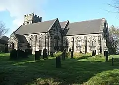 Church of St John |
| Church of St Anne | Chasetown, Burntwood, Lichfield | Chapel of Ease | 1865 | 11 October 1984 | SK0439109346 52°40′54″N 1°56′11″W |
1188075 | 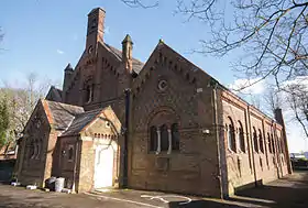 Church of St Anne |
| Conduit Head at SK 0923 0928 | Maple Hayes, Burntwood, Lichfield | Conduit Head | Mid 12th century | 15 January 1988 | SK0923009280 52°40′52″N 1°51′54″W |
1038874 |  |
| Clifton Hall | Clifton Campville, Lichfield | Country House | Early 18th century | 27 February 1964 | SK2635610994 52°41′46″N 1°36′41″W |
1038809 | |
| Former Coach House and Stable Block to Clifton Hall | Clifton Campville, Lichfield | Stable | Early 18th century | 27 February 1964 | SK2638011062 52°41′48″N 1°36′40″W |
1374279 | |
| Church of St Mary | Colton, Lichfield | Parish Church | Early 13th century | 27 February 1964 | SK0475620412 52°46′53″N 1°55′51″W |
1190499 | 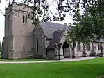 Church of St Mary |
| Colton House | Colton, Lichfield | House | c. 1730 | 9 March 1953 | SK0491020464 52°46′54″N 1°55′43″W |
1038774 | 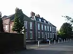 Colton House |
| Church of St Peter | Drayton Bassett, Lichfield | Parish Church | 15th century | 27 February 1964 | SK1929600209 52°35′58″N 1°43′00″W |
1374280 | 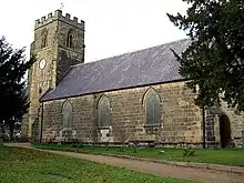 Church of St Peter |
| Chetwynd Bridge (that part in Edingale Civil Parish) | Edingale, Lichfield | Road Bridge | 1824 | 9 March 1953 | SK1880113916 52°43′21″N 1°43′23″W |
1038825 | 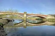 Chetwynd Bridge (that part in Edingale Civil Parish) |
| Church of St John the Baptist | Croxall, Edingale, Lichfield | Church | 18th century | 27 February 1964 | SK1975913634 52°43′12″N 1°42′32″W |
1188243 | |
| Croxall Hall and attached Garden Wall | Croxall, Edingale, Lichfield | House | Late 16th century | 9 February 1953 | SK1967013750 52°43′16″N 1°42′37″W |
1038822 | 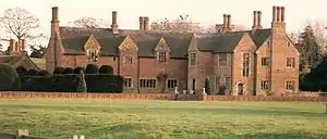 Croxall Hall and attached Garden Wall |
| Church of St Peter | Elford, Lichfield | Parish Church | Medieval | 20 November 1986 | SK1852310609 52°41′34″N 1°43′39″W |
1038899 | |
| Church of St Bartholomew | Farewell, Farewell and Chorley, Lichfield | Parish Church | c. 1300 | 27 February 1964 | SK0832311622 52°42′08″N 1°52′42″W |
1374273 | 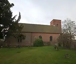 Church of St Bartholomew |
| Farewell Hall | Farewell, Farewell and Chorley, Lichfield | Farmhouse | Early 18th century | 9 March 1953 | SK0821111647 52°42′09″N 1°52′48″W |
1188143 | 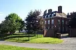 Farewell Hall |
| Chetwynd Bridge (that part in Alrewas) | Fradley and Streethay, Lichfield | Road Bridge | 1824 | 9 March 1953 | SK1879113918 52°43′21″N 1°43′24″W |
1038893 | Chetwynd Bridge (that part in Alrewas) |
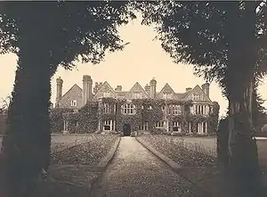
| Hamstall Hall | Hamstall Ridware, Lichfield | Country House | 15th century | 9 March 1953 | SK1050719354 52°46′18″N 1°50′45″W |
1038777 | 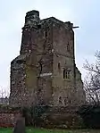 Hamstall Hall |
| Gatehouse and attached Courtyard Walls at Hamstall Hall | Hamstall Ridware, Lichfield | Gatehouse | Late 16th century | 27 February 1964 | SK1048219424 52°46′20″N 1°50′46″W |
1190607 | 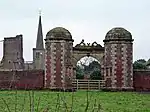 Gatehouse and attached Courtyard Walls at Hamstall Hall |
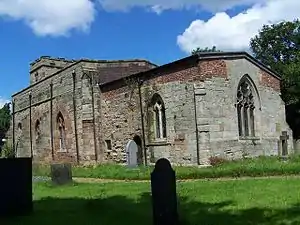
| Tower and attached Walls at Hamstall Hall | Hamstall Ridware, Lichfield | Tower | Late 15th century | 27 February 1964 | SK1054019378 52°46′19″N 1°50′43″W |
1374300 | _Ruins_of_the_Hall_-_geograph.org.uk_-_69756.jpg.webp) Tower and attached Walls at Hamstall Hall |
| Chapel immediately East of Haselour Hall | Haselour, Harlaston, Lichfield | Chapel | 14th century | 27 February 1964 | SK2067910773 52°41′39″N 1°41′44″W |
1038793 | |
| Church of St Matthew | Harlaston, Lichfield | Parish Church | Early 13th century | 27 February 1963 | SK2150210957 52°41′45″N 1°41′00″W |
1038795 | 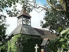 Church of St Matthew |
| Haselour Hall | Haselour, Harlaston, Lichfield | Country House | Late 16th century | 9 March 1953 | SK2064110764 52°41′39″N 1°41′46″W |
1188444 | |
| Church of St Mary and St Giles and All Saints | Canwell, Hints, Lichfield | Chapel of Ease | 1911 | 27 February 1964 | SK1410300520 52°36′08″N 1°47′36″W |
1374260 | 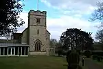 Church of St Mary and St Giles and All Saints |
| 1-12 and 12a Vicars' Close (flats) and Vicars' Hall | Lichfield | Apartment | 1994 | 5 February 1952 | SK1140409734 52°41′07″N 1°49′58″W |
1194880 | |
| Angel Croft Hotel and attached Outbuilding, Front Railings and Gates | Lichfield | Gate | c. 1750 | 5 February 1952 | SK1136509716 52°41′06″N 1°50′00″W |
1187354 | 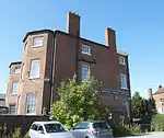 Angel Croft Hotel and attached Outbuilding, Front Railings and Gates |
| Bastion to North East Angle and attached Walls of Garden of Former Episcopal Palace | Lichfield, Lichfield | Garden Wall | Late 17th century | 6 March 1970 | SK1155709918 52°41′13″N 1°49′50″W |
1194878 | |
| Cathedral Visitors' Study Centre and attached Wall and Gate | Lichfield | Gate | Late 17th century | 5 February 1952 | SK1164109737 52°41′07″N 1°49′45″W |
1218787 | |
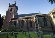
| Christ Church | Leamonsley, Lichfield | Church | 1844-47 | 6 March 1970 | SK1086709313 52°40′53″N 1°50′27″W |
1209813 | |
| Church of St Chad | Stowe, Lichfield | Tower | Late 13th century | 5 February 1952 | SK1220410209 52°41′22″N 1°49′15″W |
1298398 | |
| Church of St Mary | Lichfield | Church | Medieval | 5 February 1952 | SK1176109547 52°41′01″N 1°49′39″W |
1292270 | |
| Church of St Michael | Lichfield | Tower | 14th century | 5 February 1952 | SK1238109510 52°40′59″N 1°49′06″W |
1292420 | |
| Cruck House | Lichfield | House | 1971 | 6 March 1970 | SK1208709914 52°41′12″N 1°49′21″W |
1194899 | 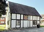 Cruck House |
| Donegal House (Tourist Information Centre) and attached Railings | Lichfield | House | 1730 | 5 February 1952 | SK1177609485 52°40′59″N 1°49′38″W |
1209722 | 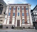 Donegal House (Tourist Information Centre) and attached Railings |
| Dr Johnson Statue | Lichfield | Statue | 1938 | 5 February 1952 | SK1174209561 52°41′01″N 1°49′40″W |
1217846 | 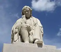 Dr Johnson Statue |
| George Hotel | Lichfield | Coaching Inn | Late 18th century | 5 February 1952 | SK1159009479 52°40′58″N 1°49′48″W |
1298735 | 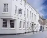 George Hotel |
| Milley's Hospital | Lichfield | Almshouse | Post 1504 | 5 February 1952 | SK1135509759 52°41′07″N 1°50′00″W |
1187347 | .jpg.webp) Milley's Hospital |
| Numbers 1-9a Newton's College and attached Gate Pier | Lichfield | Gate Pier | 1800-3 | 5 February 1952 | SK1145109691 52°41′05″N 1°49′55″W |
1194875 | 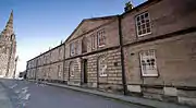 Numbers 1-9a Newton's College and attached Gate Pier |
| St John's Preparatory School and attached Garden Wall | Lichfield | House | Mid to late 18th century | 5 February 1952 | SK1171309260 52°40′51″N 1°49′41″W |
1292101 | |
| St Mary's Chambers | Lichfield | House | c. 1760 | 5 February 1952 | SK1173809524 52°41′00″N 1°49′40″W |
1292482 | 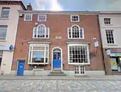 St Mary's Chambers |
| St Mary's House and attached Wall, The Close | Lichfield | House | Pre 1300 | 5 February 1952 | SK1167109782 52°41′08″N 1°49′44″W |
1218902 | |
| Stowe Hill | Lichfield | House | 1750s | 5 February 1952 | SK1235510354 52°41′27″N 1°49′07″W |
1298772 | |
| Stowe House | Stowe, Lichfield | House | c. 1750 | 6 March 1970 | SK1230010200 52°41′22″N 1°49′10″W |
1187731 | 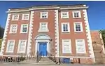 Stowe House |
| The Deanery and attached Gate, The Close | Lichfield | Deanery | c. 1707 | 5 February 1952 | SK1151109813 52°41′09″N 1°49′52″W |
1194879 | .jpg.webp) The Deanery and attached Gate, The Close |
| No 5, The Close | Lichfield | House | Early 18th century | 5 February 1952 | SK1144909707 52°41′06″N 1°49′55″W |
1194869 | 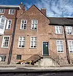 No 5, The Close |
| No 6, The Close | Lichfield | Clergy House | Early 18th century | 5 February 1952 | SK1145509710 52°41′06″N 1°49′55″W |
1298427 | 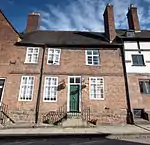 No 6, The Close |
| No 7, The Close | Lichfield | Timber Framed House | 15th century | 5 February 1952 | SK1146209714 52°41′06″N 1°49′55″W |
1218470 | 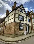 No 7, The Close |
| No 10, The Close | Lichfield | House | 16th century | 5 February 1952 | 49°46′01″N 7°33′26″W | 1194871 | 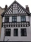 No 10, The Close |
| Nos. 23a and 23b, The Close and attached Wall and Gate | Lichfield | House | Late 15th century | 5 February 1952 | SK1150909688 52°41′05″N 1°49′52″W |
1218599 | |
| Number 24, The Close and attached Wall and Gate Pier | Lichfield | House | c. 1461 | 5 February 1952 | SK1148709689 52°41′05″N 1°49′53″W |
1298430 | 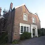 Number 24, The Close and attached Wall and Gate Pier |
| No 20, St John Street | Lichfield | House | c. 1700 | 5 February 1952 | SK1167609322 52°40′53″N 1°49′43″W |
1292115 | |
| 32 Bore Street | Lichfield | House | Late 16th century | 5 February 1952 | SK1177709461 52°40′58″N 1°49′38″W |
1292495 | 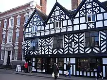 32 Bore Street |
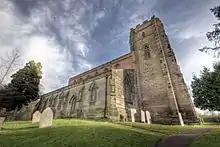
| Church of St James | Longdon, Lichfield | Parish Church | 12th century | 27 February 1964 | SK0821714163 52°43′30″N 1°52′47″W |
1248990 | 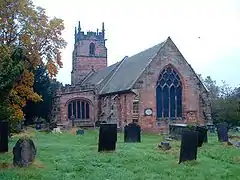 Church of St James |
| Hanch Hall | Longdon, Lichfield | House | C16/C17 | 27 February 1964 | SK1004213970 52°43′24″N 1°51′10″W |
1248899 | |
| Hill Top Cottages & Thatched Cottage | Hill Top, Longdon, Lichfield | Aisled House | Post 1399 | 27 February 1964 | SK0896214098 52°43′28″N 1°52′07″W |
1248894 | |
| Hill Top Farmhouse | Hill Top, Longdon, Lichfield | Farmhouse | Mid to late 17th century | 27 February 1964 | SK0900214089 52°43′28″N 1°52′05″W |
1277717 | |
| High Bridge | Mavesyn Ridware, Lichfield | Road Bridge | 1830 | 9 March 1953 | SK0919916757 52°44′54″N 1°51′55″W |
1190422 | 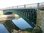 High Bridge |
| Old Hall | Mavesyn Ridware, Lichfield | House | 18th century | 9 March 1953 | SK0811516748 52°44′54″N 1°52′52″W |
1248906 | 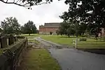 Old Hall |
| The Old Rectory and attached Walls and Gate Piers | Rake End, Mavesyn Ridware, Lichfield | House | c. 1728 | 9 March 1953 | SK0776218225 52°45′42″N 1°53′11″W |
1277601 | 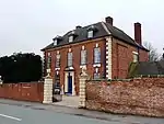 The Old Rectory and attached Walls and Gate Piers |
| Church Tower approximately 100 Metres North of Church of St John | Shenstone, Lichfield | Tower | 13th century | 27 February 1964 | SK1094404382 52°38′13″N 1°50′23″W |
1038830 | |
| Shenstone Hall | Shenstone, Lichfield | Farmhouse | 17th century | 9 March 1953 | SK1131304782 52°38′26″N 1°50′03″W |
1188184 | |
| Swinfen Hall and attached Steps and Terraces | Swinfen and Packington, Lichfield | Country House | 1755 | 26 February 1982 | SK1344605979 52°39′05″N 1°48′10″W |
1038838 | 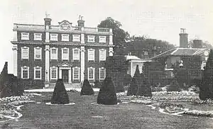 Swinfen Hall and attached Steps and Terraces |
| Church of All Saints | Statfold, Thorpe Constantine, Lichfield | Chapel | 12th century | 27 February 1964 | SK2377207171 52°39′42″N 1°39′00″W |
1294722 | |
| Whittington Old Hall | Whittington, Lichfield | House | Late medieval | 9 March 1953 | SK1622908235 52°40′18″N 1°45′41″W |
1038870 |
.jpg.webp)
Notes
- The date given is the date used by Historic England as significant for the initial building or that of an important part in the structure's description.
- Sometimes known as OSGB36, the grid reference is based on the British national grid reference system used by the Ordnance Survey.
- The "List Entry Number" is a unique number assigned to each listed building and scheduled monument by Historic England.
External links
![]() Media related to Grade II* listed buildings in Staffordshire at Wikimedia Commons
Media related to Grade II* listed buildings in Staffordshire at Wikimedia Commons
This article is issued from Wikipedia. The text is licensed under Creative Commons - Attribution - Sharealike. Additional terms may apply for the media files.