Grade II* listed buildings in Oxford
There are over 20,000 Grade II* listed buildings in England. This page is a list of these buildings in the district of Oxford in Oxfordshire.
List of buildings
| Name | Location | Type | Completed [note 1] | Date designated | Grid ref.[note 2] Geo-coordinates |
Entry number [note 3] | Image |
|---|---|---|---|---|---|---|---|
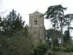
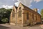
| Church of St Mary and St Nicholas | Littlemore | Church | 1836 | 18 July 1963 | SP5375502770 51°43′16″N 1°13′24″W |
1047667 | |
| Minchery Farmhouse | Littlemore | Farmhouse | c. 1600 | 18 July 1963 | SP5453502285 51°43′00″N 1°12′43″W |
1047672 | 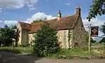 Minchery Farmhouse |
| All Souls College, Warden's Lodging | All Souls College | House | 1704 | 12 January 1954 | SP5171106285 51°45′10″N 1°15′08″W |
1046756 | 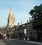 All Souls College, Warden's Lodging |
| Bartlemas House | Oxford | House | 1649 | 12 January 1954 | SP5346805502 51°44′44″N 1°13′37″W |
1047331 | .jpg.webp) Bartlemas House |
| Beam Hall, with Number 3 Merton Street | Oxford | House | 15th century and c. 1600 | 12 January 1954 | SP5169806119 51°45′05″N 1°15′09″W |
1369414 | 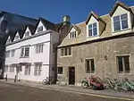 Beam Hall, with Number 3 Merton Street |
| Blue Boar Quadrangle at Christ Church | Oxford | College lodgings | 1968 | 10 October 2006 | SP5144606109 51°45′05″N 1°15′22″W |
1408741 | 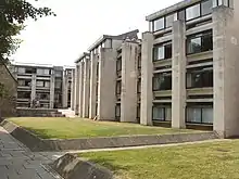 Blue Boar Quadrangle at Christ Church |
| Brasenose College Staircase 16, 17 and 18 | Brasenose College | College lodgings | 1961 | 30 March 1998 | SP5151106259 51°45′10″N 1°15′19″W |
1369494 | 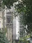 Brasenose College Staircase 16, 17 and 18 |
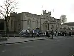
| C Wing including the Round Tower | Oxford Castle | Prison | From 1785, perhaps partly on 13th century foundations | 28 June 1972 | SP5100206087 51°45′04″N 1°15′45″W |
1047045 | 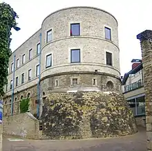 C Wing including the Round Tower |
| Campion Hall (including Chapel and Micklen Hall) | Campion Hall | College building incorporating house | 1936 and late 17th/early 18th century | 12 January 1954 | SP5131205936 51°44′59″N 1°15′29″W |
1046738 | 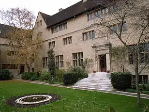 Campion Hall (including Chapel and Micklen Hall) |
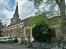
| Christ Church Picture Gallery | Oxford | Art gallery | 1965–68 | 24 April 1998 | SP5156506037 51°45′02″N 1°15′16″W |
1323703 |  |
| Christ Church: wall and screen facing Oriel Square in the north east corner of the college | Christ Church | Gate | 18th century | 28 June 1972 | SP5157206130 51°45′05″N 1°15′16″W |
1046744 | 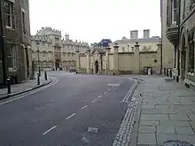 Christ Church: wall and screen facing Oriel Square in the north east corner of the college |
| Church of St Aldate | Oxford | Church | 12th century | 12 January 1954 | SP5135505999 51°45′01″N 1°15′27″W |
1100244 | |
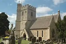
| St Andrew's Church, Headington | Oxford | Church | Mid-12th century | 12 January 1954 | SP5446507635 51°45′53″N 1°12′44″W |
1348376 | |
| Church of St Clement | Oxford | Church | 1827–28 | 12 January 1954 | SP5270606330 51°45′11″N 1°14′16″W |
1369413 | |
| Church of St Ebbe | Oxford | Church | 13th century | 12 January 1954 | SP5120306024 51°45′02″N 1°15′35″W |
1047355 | |
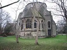
| Church of St Frideswide | Oxford | Church | 1872 | 29 January 1968 | SP5015406191 51°45′08″N 1°16′29″W |
1369349 | |
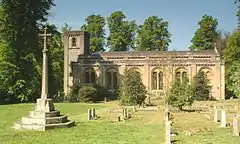
| Church of St James | Oxford | Church | Late 12th century | 12 January 1954 | SP5398403825 51°43′50″N 1°13′11″W |
1185096 | 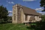 Church of St James |
| County Hall with the curving screen walls and turrets on either side | Oxford | Local government office with lamp brackets | 1841 | 29 January 1968 | SP5105306158 51°45′06″N 1°15′43″W |
1047201 | |
| Exeter College, Chapel on north side of quadrangle, Main Quadrangle | Exeter College | College chapel | 1859 | 12 January 1954 | SP5144406400 51°45′14″N 1°15′22″W |
1046721 | 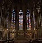 Exeter College, Chapel on north side of quadrangle, Main Quadrangle |
| Frewin Hall | Oxford | House | 1582 | 12 January 1954 | SP5117006253 51°45′10″N 1°15′36″W |
1122646 | 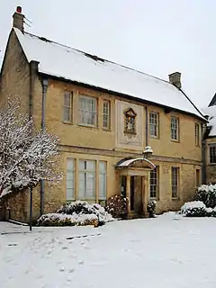 Frewin Hall |
| Garden House approximately 50 metres ENE of Number 16 (St Giles House) | Oxford | Garden house | c. 1737 | 27 July 1989 | SP5126406840 51°45′28″N 1°15′31″W |
1047042 | |
| Gates and piers at Number 16, St Giles' | Oxford | Gate | c. 1702 | 28 June 1972 | SP5120306809 51°45′27″N 1°15′34″W |
1359647 | 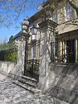 Gates and piers at Number 16, St Giles' |
| Grandpont House | Oxford | House | c. 1785 | 12 January 1954 | SP5150305450 51°44′43″N 1°15′20″W |
1299941 | |
| Greyfriars, 21 Paradise Street | Oxford | House | Late 17th century | 12 January 1954 | SP5101806037 51°45′03″N 1°15′44″W |
1369431 | 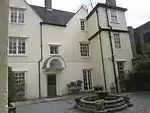 Greyfriars, 21 Paradise Street |
| Headington Hill Hall and attached forecourt wall | Oxford | Country house | 1856–58 | 7 December 1992 | SP5316806547 51°45′18″N 1°13′52″W |
1047044 | 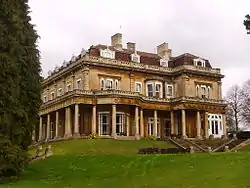 Headington Hill Hall and attached forecourt wall |
| Hertford College, East Range | Hertford College | University college | 1740 | 12 January 1954 | SP5164706433 51°45′15″N 1°15′11″W |
1369641 |  Hertford College, East Range |
| Hertford College, West Range | Hertford College | College lodgings | 1820–22 | 12 January 1954 | SP5161206424 51°45′15″N 1°15′13″W |
1046724 |  Hertford College, West Range |
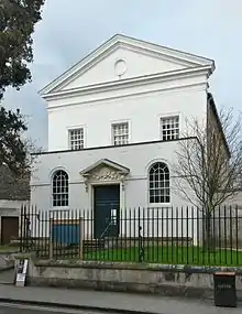
| Holywell Music Room | Oxford | Music room | 1742–48 | 12 January 1954 | SP5164406554 51°45′19″N 1°15′12″W |
1047232 | |
| Keble College, De Breyne and Hayward Buildings, including Middle Common Room and bar, Fellows flat, transformer station, workshops and gates | Oxford | Apartment | 1971–73 | 4 October 1999 | SP5131006884 51°45′30″N 1°15′29″W |
1130378 | 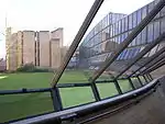 Keble College, De Breyne and Hayward Buildings, including Middle Common Room and bar, Fellows flat, transformer station, workshops and gates |
| Kemp Hall | Oxford | Cross-passage house | 1637 | 12 January 1954 | SP5142506168 51°45′07″N 1°15′23″W |
1145872 | 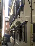 Kemp Hall |
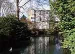
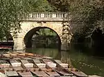
| Magdalen Bridge | Oxford | Bridge | 1772–90 | 12 January 1954 | SP5213106102 51°45′04″N 1°14′46″W |
1369360 | |
| Magdalen College, boundary wall of the Grove | Magdalen College | Boundary wall | Late 15th century | 12 January 1954 | SP5199606541 51°45′19″N 1°14′53″W |
1046708 | 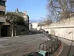 Magdalen College, boundary wall of the Grove |
| Magdalen College, the New School Room, now New Library | Magdalen College | Library | 1851 | 12 January 1954 | SP5197806241 51°45′09″N 1°14′54″W |
1283219 | 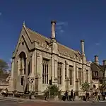 Magdalen College, the New School Room, now New Library |
| Magdalen College, the Old Grammar Hall | Magdalen College | University college | 1614 | 12 January 1954 | SP5205806239 51°45′09″N 1°14′50″W |
1046706 | 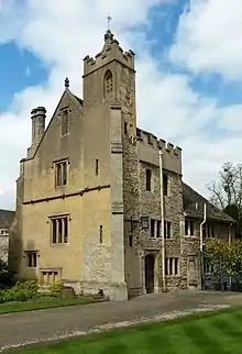 Magdalen College, the Old Grammar Hall |
| Magdalen Gate House | Oxford | Gatehouse | Late 18th century | 12 January 1954 | SP5199106188 51°45′07″N 1°14′54″W |
1047287 | 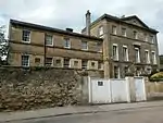 Magdalen Gate House |
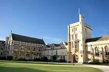
| Mansfield College | Mansfield College | Theological college | 1886 | 12 January 1954 | SP5164606817 51°45′28″N 1°15′11″W |
1046678 | |
| Merton College, South Range Hall, Front Quadrangle | Merton College | Assembly hall | 13th century | 12 January 1954 | SP5173906078 51°45′04″N 1°15′07″W |
1369660 | .jpg.webp) Merton College, South Range Hall, Front Quadrangle |
| New College, iron screen, Garden Quadrangle | New College | University college | 1711 | 12 January 1954 | SP5183306407 51°45′14″N 1°15′02″W |
1046689 | 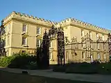 New College, iron screen, Garden Quadrangle |
| Pembroke College, Master's Lodging | Pembroke College | Teachers' house, former Almshouses | Early 16th century, converted 1927 | 12 January 1954 | SP5138405965 51°45′00″N 1°15′25″W |
1046665 | 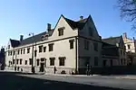 Pembroke College, Master's Lodging |
| Pembroke College, Staircase 16 (part of) | Pembroke College | College lodgings | Early 17th century | 12 January 1954 | SP5129006027 51°45′02″N 1°15′30″W |
1046667 | 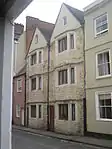 Pembroke College, Staircase 16 (part of) |
| Florey Building, Queen's College | St Clement's | College lodgings | 1971 | 12 March 2009 | SP5234306082 51°45′03″N 1°14′35″W |
1393211 | .jpg.webp) Florey Building, Queen's College |
| Iffley Rectory | Oxford | Vicarage | 13th century | 12 January 1954 | SP5268803478 51°43′39″N 1°14′19″W |
1047193 | 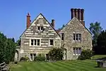 Iffley Rectory |
| Rhodes House | Oxford | University building with Library | 1929 | 12 January 1954 | SP5151906809 51°45′27″N 1°15′18″W |
1076964 | |
| St Bartholomew's Farmhouse | Oxford | Farmhouse | 16th century | 12 January 1954 | SP5342805470 51°44′43″N 1°13′39″W |
1299369 | 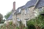 St Bartholomew's Farmhouse |
| St Peter's College, Master's Lodge, former Oxford Canal Company offices | St Peter's College | University college, former office | 1829 | 12 January 1954 | SP5109006222 51°45′09″N 1°15′41″W |
1046618 | 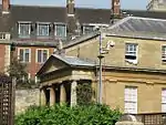 St Peter's College, Master's Lodge, former Oxford Canal Company offices |
| Stable wing and garden walls of Iffley Rectory | Oxford | Gate | 18th century | 12 January 1954 | SP5259503519 51°43′41″N 1°14′24″W |
1369399 | 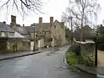 Stable wing and garden walls of Iffley Rectory |
| Stones Almshouses (8 tenements) | Oxford | Almshouse | 1700 | 12 January 1954 | SP5251305999 51°45′01″N 1°14′27″W |
1047125 | 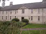 Stones Almshouses (8 tenements) |
| The Judges Lodging | Oxford | House | 1702 | 12 January 1954 | SP5121206821 51°45′28″N 1°15′34″W |
1047136 | 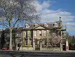 The Judges Lodging |
| Summertown Villa, formerly The Lodge, 304, Woodstock Road | Oxford | Villa | c. 1830 | 6 June 2001 | SP5044709435 51°46′53″N 1°16′13″W |
1246138 | 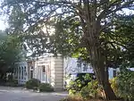 Summertown Villa, formerly The Lodge, 304, Woodstock Road |
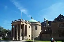
| The Martyrs' Memorial | Oxford | Commemorative monument | 1841 | 12 January 1954 | SP5124506525 51°45′18″N 1°15′32″W |
1107172 | |
| The Mitre Hotel | Oxford | Inn | c. 1300 | 12 January 1954 | SP5145006222 51°45′08″N 1°15′22″W |
1369357 | 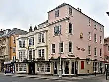 The Mitre Hotel |
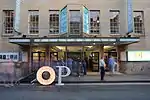
| The Playhouse, Beaumont Street | Oxford | Theatre | 1938 | 12 January 1954 | SP5107406499 51°45′17″N 1°15′41″W |
1185150 | |
| The Radcliffe Infirmary (Main Block) | Oxford | Infirmary | 1759–70 | 12 January 1954 | SP5100907073 51°45′36″N 1°15′44″W |
1047066 | 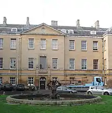 The Radcliffe Infirmary (Main Block) |
| Rhodes Building, north range of St Mary's Quad, Oriel College | Oxford | University college | 1909–11 | 28 June 1972 | SP5161406233 51°45′09″N 1°15′13″W |
1046662 |  Rhodes Building, north range of St Mary's Quad, Oriel College |
| The University Printing House (the Clarendon Press) | Oxford | Printing works | 1826–28 | 12 January 1954 | SP5085806914 51°45′31″N 1°15′52″W |
1052359 | 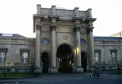 The University Printing House (the Clarendon Press) |
| Oxford Town Hall, Municipal Buildings and Library | Oxford | Local government office | 1893–97 | 12 January 1954 | SP5137906136 51°45′06″N 1°15′26″W |
1047153 | 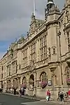 Oxford Town Hall, Municipal Buildings and Library |
| Trinity College, gatepiers and grille | Trinity College | Gate pier | 1713 | 12 January 1954 | SP5149906626 51°45′21″N 1°15′19″W |
1046630 | 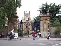 Trinity College, gatepiers and grille |
| Trinity College, Kettell Hall | Trinity College | House | 1618–20 | 12 January 1954 | SP5146006476 51°45′17″N 1°15′21″W |
1230901 | 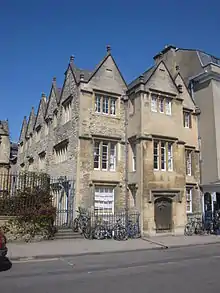 Trinity College, Kettell Hall |
| Tudor House, 94 High Street/1 Magpie Lane | Oxford | Timber-framed house | 16th century | 12 January 1954 | SP5164006239 51°45′09″N 1°15′12″W |
1369388 | 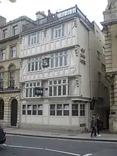 Tudor House, 94 High Street/1 Magpie Lane |
| University of Oxford, St Cross Building | Oxford | University building with libraries | 1961–65 | 30 March 1993 | SP5200906758 51°45′26″N 1°14′52″W |
1369496 | University of Oxford, St Cross Building |
| Vanbrugh House, St Michael's Street | Oxford | House | 17th century | 12 January 1954 | SP5119406340 51°45′12″N 1°15′35″W |
1068871 | 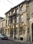 Vanbrugh House, St Michael's Street |
| Wadham College, South Block | Wadham College | Gate | 1694, c. 1796 | 12 January 1954 | SP5154606566 51°45′20″N 1°15′17″W |
1046599 | 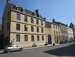 Wadham College, South Block |
| 26 Ship Street | Oxford | House | 15th century | 12 January 1954 | SP5129206349 51°45′13″N 1°15′30″W |
1047091 | 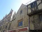 26 Ship Street |
| 24–37 Beaumont Street | Oxford | House | 1828–37 | 12 January 1954 | SP5106406525 51°45′18″N 1°15′42″W |
1047375 |  24–37 Beaumont Street |
| 86 and 87 High Street | Oxford | House | Early 17th century | 12 January 1954 | SP5181206244 51°45′09″N 1°15′03″W |
1047248 |  86 and 87 High Street |
| 35 Holywell Street | Oxford | House | 1626 | 12 January 1954 | SP5163006534 51°45′18″N 1°15′12″W |
1047234 | 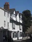 35 Holywell Street |
| 41 St Giles Street | Oxford | House | c. 1700 | 12 January 1954 | SP5113806808 51°45′27″N 1°15′38″W |
1047144 | 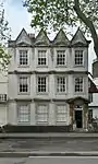 41 St Giles Street |
| 12 Oriel Street | Oxford | Timber-framed house | 17th century | 12 January 1954 | SP5159106165 51°45′07″N 1°15′15″W |
1047173 | 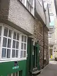 12 Oriel Street |
| 82 and 83 St Aldates Street | Oxford | House | 15th century | 12 January 1954 | SP5140405834 51°44′56″N 1°15′24″W |
1047154 | 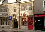 82 and 83 St Aldates Street |
| 106 and 107 High Street | Oxford | House | 14th century | 12 January 1954 | SP5156806218 51°45′08″N 1°15′16″W |
1047253 | 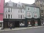 106 and 107 High Street |
| 6 High Street | Oxford | House | Late 18th century | 12 January 1954 | SP5137106206 51°45′08″N 1°15′26″W |
1047311 | 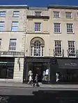 6 High Street |
| 40 St Giles Street | Oxford | House | Late 17th century | 12 January 1954 | SP5112706816 51°45′28″N 1°15′38″W |
1068575 | 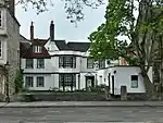 40 St Giles Street |
| 13 and 14 Pembroke Street | Oxford | House | 1641; altered in 18th–19th centuries | 12 January 1954 | SP5131806023 51°45′02″N 1°15′29″W |
1099196 | 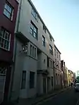 13 and 14 Pembroke Street |
| 38 Pembroke Street | Oxford | Timber-framed house | 17th century | 12 January 1954 | SP5129306040 51°45′03″N 1°15′30″W |
1369435 | 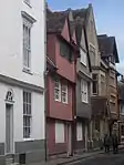 38 Pembroke Street |
| 53 and 54 St Giles Street | Oxford | House | c. 1600 | 12 January 1954 | SP5115406743 51°45′25″N 1°15′37″W |
1369439 | 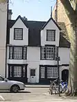 53 and 54 St Giles Street |
| 118 High Street | Oxford | House | 16th century, refronted in 19th century | 12 January 1954 | SP5149206202 51°45′08″N 1°15′20″W |
1047257 | 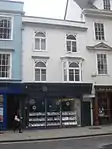 118 High Street |
| 3 Cornmarket Street | Oxford | House | 15th to 17th century | 12 January 1954 | SP5134006215 51°45′08″N 1°15′28″W |
1185643 |  3 Cornmarket Street |
_(14580602248).jpg.webp)
See also
Notes
- The date given is the date used by Historic England as significant for the initial building or that of an important part in the structure's description.
- Sometimes known as OSGB36, the grid reference is based on the British national grid reference system used by the Ordnance Survey.
- The "List Entry Number" is a unique number assigned to each listed building and scheduled monument by Historic England.
External links
![]() Media related to Grade II* listed buildings in Oxfordshire at Wikimedia Commons
Media related to Grade II* listed buildings in Oxfordshire at Wikimedia Commons
This article is issued from Wikipedia. The text is licensed under Creative Commons - Attribution - Sharealike. Additional terms may apply for the media files.