Grade II* listed buildings in Portsmouth
There are over 20,000 Grade II* listed buildings in England. This page is a list of these buildings in the City of Portsmouth in Hampshire.
City of Portsmouth
| Name | Location | Type | Completed [note 1] | Date designated | Grid ref.[note 2] Geo-coordinates |
Entry number [note 3] | Image |
|---|---|---|---|---|---|---|---|
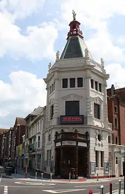
| The Kings Theatre | Southsea, City of Portsmouth | Apartment | 1907 | 4 March 1976 | SZ6486599005 50°47′13″N 1°04′52″W |
1386801 | |
| Buckingham House | City of Portsmouth | Apartment | 1953 | 10 January 1953 | SZ6347899493 50°47′30″N 1°06′03″W |
1104356 | |
| Church of St Agatha | Landport, City of Portsmouth | Exhibition Hall | 1990 | 30 October 1969 | SU6407000697 50°48′08″N 1°05′32″W |
1245260 | |
| Church of St George | Portsea, City of Portsmouth | Church | 1754 | 10 January 1953 | SU6332000087 50°47′49″N 1°06′11″W |
1387161 |  Church of St George |
| Church of St Mary, Kingston | Fratton, City of Portsmouth | Church | 1887-1889 | 10 January 1953 | SU6518900850 50°48′13″N 1°04′35″W |
1104279 |  Church of St Mary, Kingston |
| Church of St Peter and St Paul | Wymering, City of Portsmouth | Church | Medieval | 10 January 1953 | SU6503105541 50°50′45″N 1°04′40″W |
1245265 |  Church of St Peter and St Paul |
| Admiralty House (Building No 1/20) and attached Railings | H.M. Naval Base, City of Portsmouth | Naval Officers House | 1784-1786 | 13 August 1999 | SU6311800505 50°48′02″N 1°06′21″W |
1244604 | 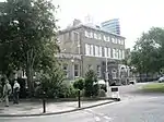 Admiralty House (Building No 1/20) and attached Railings |
| Victory Gate and Dockyard Wall | H.M. Naval Base, City of Portsmouth | Gate | 1704-1712 | 13 August 1999 | SU6309800391 50°47′59″N 1°06′22″W |
1244581 |  Victory Gate and Dockyard Wall |
| Fire Station (Building No 1/77) | H.M. Naval Base, City of Portsmouth | Water Tower | 1843-1844 | 13 August 1999 | SU6307200622 50°48′06″N 1°06′23″W |
1272306 |  |
| Former Royal Naval Academy (Buildings Nos 1/14, 1/116-19) and attached Railings | H.M. Naval Base, City of Portsmouth | Officers' Mess | 1999 | 13 August 1999 | SU6313700446 50°48′01″N 1°06′20″W |
1244573 | 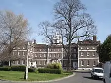 Former Royal Naval Academy (Buildings Nos 1/14, 1/116-19) and attached Railings |
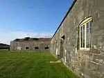
| Fort Cumberland | Eastney, City of Portsmouth | Fort | 1786 | 30 October 1969 | SZ6828399138 50°47′16″N 1°01′58″W |
1104273 | |
| Fort Purbrook (that part in Portsmouth Church Parish) | City of Portsmouth | Fort | c. 1860 | 30 October 1969 | SU6783706371 50°51′10″N 1°02′16″W |
1387127 |  Fort Purbrook (that part in Portsmouth Church Parish) |
| Fort Widley | City of Portsmouth | Barracks | c. 1913 | 30 October 1969 | SU6567506434 50°51′13″N 1°04′06″W |
1387128 | |
| Iron Foundry (Building No 1/140), including Railings and Bollards | H.M. Naval Base, City of Portsmouth | Cannon Bollard | Mid-Late 19th century | 13 August 1999 | SU6309900831 50°48′13″N 1°06′21″W |
1272310 | |
| Long Row (Building Nos 1/124-132) and attached Walls (Spithead House) | H.M. Naval Base, City of Portsmouth | House | 1999 | 13 August 1999 | SU6309500720 50°48′09″N 1°06′22″W |
1272307 | |
| No 15 Store (Building Number 1/62) and Bollard at South East Corner | H.M. Naval Base, City of Portsmouth | Cannon Bollard | Mid/Late C20 | 13 August 1999 | SU6297600507 50°48′03″N 1°06′28″W |
1272262 | |
| No 16 Store (Building No 1/63) and Bollard at South West Corner | H.M. Naval Base, City of Portsmouth | Cannon Bollard | Mid/Late 19th century | 13 August 1999 | SU6303800525 50°48′03″N 1°06′25″W |
1272263 | |
| No 17 Store (Building No 1/64) and Bollards at North West and South West Corners | H.M. Naval Base, City of Portsmouth | Cannon Bollard | Mid/Late C20 | 13 August 1999 | SU6310100546 50°48′04″N 1°06′21″W |
1272265 | |
| No 2 Ship Shop (Building Number 1/208) | H.M. Naval Base, City of Portsmouth | Turning Shop | 1846-1849 | 13 August 1999 | SU6293500954 50°48′17″N 1°06′30″W |
1272270 | |
| No 25 Store (Building No 1/118) | H.M. Naval Base, City of Portsmouth | Workshop | 1782 | 13 August 1999 | SU6301700652 50°48′07″N 1°06′26″W |
1244578 | |
| No 6 Boathouse (Building No 1/23) and Slipway to Front | H.M. Naval Base, City of Portsmouth | Boat House | Later alterations | 13 August 1999 | SU6304400421 50°48′00″N 1°06′24″W |
1244594 | 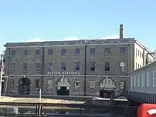 No 6 Boathouse (Building No 1/23) and Slipway to Front |
| Nos 10 to 14 and attached Railings and Walls (Building Nos 1/68-72) | H.M. Naval Base, City of Portsmouth | House | 1999 | 13 August 1999 | SU6320700616 50°48′06″N 1°06′16″W |
1244549 | |
| Nos 18 and 19 Stores with linking and attached Bollards (Buildings Nos 1/65 and 75) | H.M. Naval Base, City of Portsmouth | Stores | Late C18/Early 19th century | 13 August 1999 | SU6309200576 50°48′05″N 1°06′22″W |
1272305 | |
| Porters Lodge (Building No 1/7) | H.M. Naval Base, City of Portsmouth | Porters Lodge | c. 1708 | 13 August 1999 | SU6301800321 50°47′57″N 1°06′26″W |
1244584 | 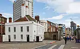 Porters Lodge (Building No 1/7) |
| South Office Block (Building No 1/88) | H.M. Naval Base, City of Portsmouth | Storehouse | 1789 | 13 August 1999 | SU6292300572 50°48′05″N 1°06′30″W |
1272314 | |
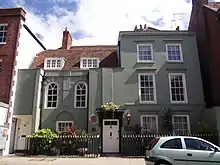
| No 2, St Georges Way and attached Garden Wall | Portsea, City of Portsmouth | House | Late 18th century | 30 October 1969 | SU6351500241 50°47′54″N 1°06′00″W |
1387162 | |
| The Beneficial School | Portsea, City of Portsmouth | School | 1784 | 10 January 1953 | SU6332700221 50°47′53″N 1°06′10″W |
1271859 |  The Beneficial School |
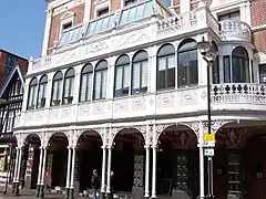
| New Theatre Royal | Landport, City of Portsmouth | Public Hall | 1854 | 30 October 1969 | SU6400200048 50°47′47″N 1°05′36″W |
1104328 | |
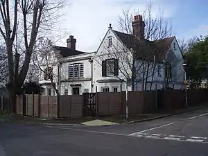
| Wymering Manor | Cosham, City of Portsmouth | House | Extended c1900 - before 1908 | 10 January 1953 | SU6499305588 50°50′46″N 1°04′42″W |
1245180 | |
| 1, 3 and 5 Lombard Street | City of Portsmouth | House | Mid to Late 17th century | 10 January 1953 | SZ6324699436 50°47′28″N 1°06′15″W |
1103826 | |
| 3 Penny Street | City of Portsmouth | House | Late C18/Early 19th century | 30 October 1969 | SZ6347099388 50°47′26″N 1°06′03″W |
1103863 | |
| 1 Penny Street | City of Portsmouth | House | Late 18th century | 10 January 1953 | SZ6348099395 50°47′26″N 1°06′03″W |
1103861 | |
| City of Portsmouth War Memorial | Guildhall Square | War memorial | 1921 | 19 October 1921 | SU6405100226 | 1104318 |


Notes
- The date given is the date used by Historic England as significant for the initial building or that of an important part in the structure's description.
- Sometimes known as OSGB36, the grid reference is based on the British national grid reference system used by the Ordnance Survey.
- The "List Entry Number" is a unique number assigned to each listed building and scheduled monument by Historic England.
External links
![]() Media related to Grade II* listed buildings in Hampshire at Wikimedia Commons
Media related to Grade II* listed buildings in Hampshire at Wikimedia Commons
This article is issued from Wikipedia. The text is licensed under Creative Commons - Attribution - Sharealike. Additional terms may apply for the media files.
