Grade II* listed buildings in Purbeck (district)
There are over 20,000 Grade II* listed buildings in England. This page is a list of these buildings in the district of Purbeck in Dorset.
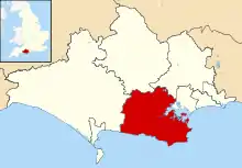
Purbeck shown in Dorset
Purbeck
| Name | Location | Type | Completed [note 1] | Date designated | Grid ref.[note 2] Geo-coordinates |
Entry number [note 3] | Image |
|---|---|---|---|---|---|---|---|
| First World War Memorial | Affpuddle | Cross | 1918 | 2 October 1984 | SY8128593292 50°44′20″N 2°16′00″W |
1171702 | 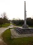 First World War Memorial |
| Brewhouse and Ice House at Bloxworth House, Approximately 30 M South of House | Bloxworth | Brewhouse | Probably mid 17th century | 28 March 1984 | SY8794794961 50°45′15″N 2°10′20″W |
1120570 |  |
| Pump House at Bloxworth House, Approximately 50 Metres South South East of the House | Bloxworth | Pump house | Late 17th to early 18th century | 28 March 1984 | SY8798094918 50°45′13″N 2°10′18″W |
1323294 | |
| Stables at Bloxworth House, Approximately 10 Metres East of the House | Bloxworth | Stable | 1669 | 20 November 1959 | SY8798194962 50°45′15″N 2°10′18″W |
1323275 | |
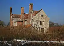
| The Grange | East Chaldon, Chaldon Herring | House | 16th century | 20 November 1959 | SY7904483101 50°38′50″N 2°17′52″W |
1120524 | |
| Parish Church of Saint Peter | Church Knowle | Parish church | 14th century | 20 November 1959 | SY9407881938 50°38′14″N 2°05′06″W |
1303812 | 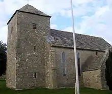 Parish Church of Saint Peter |
| North Lodges Lulworth Castle | Coombe Keynes | Gate lodge | 1785 | 2 October 1984 | SY8483183344 50°38′58″N 2°12′57″W |
1323333 | 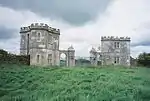 North Lodges Lulworth Castle |
| Encombe House | Encombe, Corfe Castle | Country house | Probably 17th century | 20 November 1959 | SY9445378571 50°36′25″N 2°04′47″W |
1230202 | |
| Furzeman's House | Corfe Castle | Cross passage house | Late medieval | 20 November 1959 | SY9596381805 50°38′09″N 2°03′30″W |
1230731 | |
| Morton's House. Including Attached Outbuildings and Front Boundary Wall | Corfe Castle | Manor house | Late 16th to early 17th century | 20 November 1959 | SY9614682027 50°38′17″N 2°03′21″W |
1229002 | |
| Parish Church of Saint Edward | The Square, Corfe Castle | Parish church | 15th century tower | 20 November 1959 | SY9605682050 50°38′17″N 2°03′26″W |
1278555 | 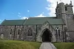 Parish Church of Saint Edward |
| Scoles Farm House, Including Attached Outbuilding at Rear, and Boundary Wall and Gate to Front Garden | Lynch, Corfe Castle | Farmhouse | Early 17th century | 20 November 1959 | SY9637079957 50°37′10″N 2°03′10″W |
1120229 | |
| The Old Town Hall | Corfe Castle | Town hall | c. 1774 | 20 November 1959 | SY9603282053 50°38′17″N 2°03′27″W |
1121006 | 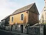 The Old Town Hall |
| The Town House | The Square, Corfe Castle | House | Late 18th century | 20 November 1959 | SY9603482072 50°38′18″N 2°03′27″W |
1230601 | |
| Parish Church of St Andrew | Lulworth Park, East Lulworth | Parish church | Tower late 15th century | 20 November 1959 | SY8537682079 50°38′18″N 2°12′29″W |
1120466 |  Parish Church of St Andrew |
| Park Lodge | East Lulworth | Detached house | 17th century | 2 October 1984 | SY8515483089 50°38′50″N 2°12′41″W |
1172531 | |
| Holme Bridge | East Stoke | Bridge | Early 17th century | 20 November 1959 | SY8904986652 50°40′46″N 2°09′23″W |
1120572 | 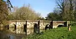 Holme Bridge |
| Wool Bridge That Part in the Parish of East Stoke | East Stoke | Bridge | 16th century | 20 November 1959 | SY8445187160 50°41′02″N 2°13′17″W |
1171233 | 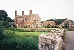 Wool Bridge That Part in the Parish of East Stoke |
| Woolbridge Manor | East Stoke | Manor house | Early 17th century | 20 November 1959 | SY8440387203 50°41′03″N 2°13′20″W |
1323300 | |
| Smedmore House | Smedmore, Kimmeridge | Manor house | 18th century | 20 November 1959 | SY9241578855 50°36′34″N 2°06′31″W |
1305067 | |
| Post Green House | Lytchett Minster | Country house | Mid to late 18th century | 20 November 1952 | SY9579393515 50°44′28″N 2°03′40″W |
1120334 | 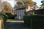 Post Green House |
| Saint Aldhelm's Church | Pit Bottom, Lytchett Minster | Private chapel | 1898 | 30 August 1984 | SY9692294514 50°45′01″N 2°02′42″W |
1120333 | |
| Charborough Tower | Charborough Park, Morden | Tower | 1790 | 20 November 1959 | SY9292397558 50°46′39″N 2°06′06″W |
1120555 | 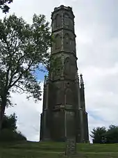 Charborough Tower |
| Home Farm House | Morden | House | Late 16th century origin | 24 March 1971 | SY9164395570 50°45′35″N 2°07′11″W |
1171734 | |
| Parish Church of Saint Mary, Charborough | Charborough Park, Morden | Parish church | 1775 | 20 November 1959 | SY9251597852 50°46′49″N 2°06′27″W |
1120553 | |
| Peacock Lodge Including Gate Piers and Gates | Charborough Park, Morden | Lodge | Late 18th to early 19th century | 28 March 1984 | SY9194198482 50°47′09″N 2°06′56″W |
1323289 | |
| Parish Church of Ss Magnus the Martyr and Nicholas of Myra | Moreton | Parish church | 1776 | 20 November 1959 | SY8054089281 50°42′10″N 2°16′37″W |
1172650 |  Parish Church of Ss Magnus the Martyr and Nicholas of Myra |
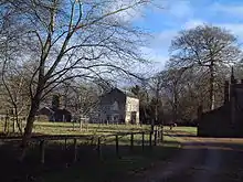
| Chapel of St John the Evangelist (Creech Grange) | Steeple | Chapel of ease | 1746 | 20 November 1959 | SY9106282424 50°38′29″N 2°07′40″W |
1323359 |  Chapel of St John the Evangelist (Creech Grange) |
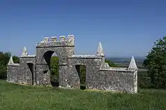
| Grange Arch | Steeple | Arch | 18th century, before 1746 | 20 November 1959 | SY9126081777 50°38′08″N 2°07′30″W |
1120456 | |
| The Manor House, Including the Wall and Gate Piers Extending North West from the South West End of the Main Block | Steeple | Detached house | c. 1600 origin | 20 November 1959 | SY9116881055 50°37′45″N 2°07′34″W |
1120422 | _-_geograph.org.uk_-_567647.jpg.webp) The Manor House, Including the Wall and Gate Piers Extending North West from the South West End of the Main Block |
| Church of Saint Mary | Brownsea Island, Studland | Parish church | 1854 | 13 December 1984 | SZ0282287772 50°41′23″N 1°57′41″W |
1323430 | 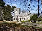 Church of Saint Mary |
| Newton Manor | Swanage | Farmhouse | Probably 18th century | 26 June 1952 | SZ0204778934 50°36′36″N 1°58′21″W |
1119898 | |
| Black Bear Hotel | Wareham | Hotel | Mid 18th century | 7 May 1952 | SY9233987292 50°41′07″N 2°06′35″W |
1323601 |  Black Bear Hotel |
| Clouds Hill (Lawrence of Arabia's Cottage) | Clouds Hill, Wareham | House | 1808 | 12 November 1959 | SY8237690910 50°43′03″N 2°15′04″W |
1120423 | 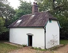 Clouds Hill (Lawrence of Arabia's Cottage) |
| No 22 (St Michaels House) | Wareham | House | Mid 18th century | 8 April 1976 | SY9221187337 50°41′08″N 2°06′42″W |
1119949 | |
| Streche's Almhouses | Wareham | Almshouse | 1741 | 7 May 1952 | SY9237187380 50°41′10″N 2°06′34″W |
1120010 |  Streche's Almhouses |
| The Priory of Lady St Mary Including Walls Immediately to West | Wareham | House | Early 16th century | 7 May 1952 | SY9249387166 50°41′03″N 2°06′27″W |
1120030 |  The Priory of Lady St Mary Including Walls Immediately to West |
| 41 West Street | Wareham | Shop | 18th century | 7 May 1952 | SY9216687307 50°41′07″N 2°06′44″W |
1323584 | |
| 12 South Street | Wareham | Shop | 18th century | 7 May 1952 | SY9233887300 50°41′07″N 2°06′35″W |
1153507 | |
| 12 West Street | Wareham | Shop | 18th century | 7 May 1952 | SY9224987354 50°41′09″N 2°06′40″W |
1119948 | |
| Little Bindon | West Lulworth | Chapel | Early 13th century origin | 20 November 1959 | SY8305279861 50°37′06″N 2°14′27″W |
1323346 | |
| Manor House | Winfrith Newburgh | House | Late 16th century origin | 20 November 1959 | SY8053784418 50°39′33″N 2°16′36″W |
1152783 | |
| Parish Church of St Christopher | Winfrith Newburgh | Parish church | 15th century tower | 20 November 1959 | SY8051284351 50°39′31″N 2°16′37″W |
1120390 |  Parish Church of St Christopher |
| Winfrith House | Winfrith Newburgh | House | 18th century | 20 November 1959 | SY8068584622 50°39′39″N 2°16′29″W |
1120384 | |
| Bindon Abbey House | Wool | House | c. 1794 | 20 November 1959 | SY8465986877 50°40′53″N 2°13′07″W |
1120359 | |
| Gatehouse at Bindon Abbey House | Wool | Gatehouse | c. 1794 | 20 November 1959 | SY8530586747 50°40′49″N 2°12′34″W |
1259827 | |
| Parish Church of the Holy Rood | Wool | Parish church | 13th century | 20 November 1959 | SY8475086463 50°40′39″N 2°13′02″W |
1120365 |  Parish Church of the Holy Rood |
| Wool Bridge | Wool | Bridge | 16th century | 20 November 1959 | SY8445587149 50°41′02″N 2°13′17″W |
1323368 | 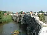 Wool Bridge |
| Dunshay Manor House | Worth Matravers | Manor house | Late 16th to early 17th century origin | 20 November 1959 | SY9808479638 50°36′59″N 2°01′42″W |
1120292 | |
_-_geograph.org.uk_-_648850.jpg.webp)
_-_geograph.org.uk_-_648794.jpg.webp)
See also
Notes
- The date given is the date used by Historic England as significant for the initial building or that of an important part in the structure's description.
- Sometimes known as OSGB36, the grid reference is based on the British national grid reference system used by the Ordnance Survey.
- The "List Entry Number" is a unique number assigned to each listed building and scheduled monument by Historic England.
External links
![]() Media related to Grade II* listed buildings in Dorset at Wikimedia Commons
Media related to Grade II* listed buildings in Dorset at Wikimedia Commons
This article is issued from Wikipedia. The text is licensed under Creative Commons - Attribution - Sharealike. Additional terms may apply for the media files.
