Grade II* listed buildings in Redcar and Cleveland
There are over 20,000 Grade II* listed buildings in England. This page is a list of these buildings in the district of Redcar and Cleveland in North Yorkshire.
Redcar and Cleveland
| Name | Location | Type | Completed [note 1] | Date designated | Grid ref.[note 2] Geo-coordinates |
Entry number [note 3] | Image |
|---|---|---|---|---|---|---|---|
| Church of St Nicholas | Guisborough, Redcar and Cleveland | Church | pre-1086 | 14 June 1952 | NZ6165016118 54°32′12″N 1°02′55″W |
1329545 | 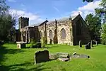 Church of St Nicholas |
| Church of St Oswald | Newton Under Roseberry, Guisborough, Redcar and Cleveland | Church | Earlier than 12th century | 25 April 1984 | NZ5692413255 54°30′41″N 1°07′20″W |
1139807 | 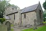 Church of St Oswald |
| Estate Office, Former Joiner's Workshop to West of Home Farmhouse | Guisborough, Redcar and Cleveland | Joiners Shop | Mid 19th century | 16 May 2001 | NZ5952914368 54°31′16″N 1°04′55″W |
1271502 |  Estate Office, Former Joiner's Workshop to West of Home Farmhouse |
| Old Church of St Andrew | Upleatham, Guisborough, Redcar and Cleveland | Church | 12th century | 14 June 1952 | NZ6371219367 54°33′56″N 1°00′58″W |
1139759 |  Old Church of St Andrew |
| Stables, Cart Shed, Granary, Barn and Loose Boxes, to East of Home Farmhouse | Hutton Lowcross, Guisborough, Redcar and Cleveland | Barn | 1826 | 25 April 1984 | NZ5959314354 54°31′16″N 1°04′51″W |
1159574 |  |
| Tocketts Mill | Guisborough, Redcar and Cleveland | Watermill | Earlier than c1810 | 30 April 1974 | NZ6269318108 54°33′16″N 1°01′56″W |
1329554 |  Tocketts Mill |
| Church of St Michael | Liverton Village, Loftus, Redcar and Cleveland | Church | 12th century | 20 January 1967 | NZ7111216306 54°32′13″N 0°54′09″W |
1139676 | 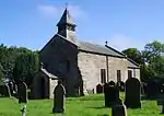 Church of St Michael |
| Inclined Tramway (lower Building) | Saltburn, Saltburn, Marske and New Marske, Redcar and Cleveland | Engine House | 1884 | 26 February 1999 | NZ6661721707 54°35′10″N 0°58′15″W |
1387519 | .jpg.webp) Inclined Tramway (lower Building) |
| Inclined Tramway (upper Building) | Saltburn, Saltburn, Marske and New Marske, Redcar and Cleveland | Incline Keepers Cottage | 1884 | 26 February 1999 | NZ6659721653 54°35′09″N 0°58′16″W |
1387523 | .jpg.webp) Inclined Tramway (upper Building) |
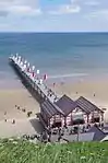
| Saltburn Pier | Saltburn, Saltburn, Marske and New Marske, Redcar and Cleveland | Pleasure Pier | 1867-1869 | 20 May 1974 | NZ6665621830 54°35′14″N 0°58′12″W |
1387526 | |
| War Memorial | Saltburn, Saltburn, Marske and New Marske, Redcar and Cleveland | War Memorial | 1919 | 26 May 1999 | NZ6651221112 54°34′51″N 0°58′21″W |
1387499 |  War Memorial |
| Church of All Saints | Skelton, Skelton and Brotton, Redcar and Cleveland | Church | 11th century | 25 May 1966 | NZ6605818994 54°33′43″N 0°58′48″W |
1250407 |  Church of All Saints |
| Old Church of All Saints | Skelton, Skelton and Brotton, Redcar and Cleveland | Church | Medieval | 25 May 1966 | NZ6525219038 54°33′45″N 0°59′33″W |
1263246 | |
| Rushpool Hall | Skelton, Skelton and Brotton, Redcar and Cleveland | Bath House | 1863 | 8 October 1975 | NZ6654420541 54°34′33″N 0°58′20″W |
1251344 | 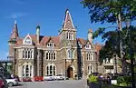 Rushpool Hall |
| Baptist Church | Redcar and Cleveland | Baptist Chapel | 1905 | 29 April 1988 | NZ5352420781 54°34′46″N 1°10′24″W |
1160408 | 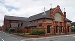 Baptist Church |
| Bastion 100 Metres North West of Kirkleatham Hall Farm | Kirkleatham, Redcar and Cleveland | Bastion | Early 18th century | 23 June 1952 | NZ5943622015 54°35′23″N 1°04′54″W |
1160124 |  Bastion 100 Metres North West of Kirkleatham Hall Farm |
| Bastion and Adjoining Ha Ha Wall 150 Metres North of Kirkleatham Hall Farm | Kirkleatham, Redcar and Cleveland | Ha Ha | Early 18th century | 23 June 1952 | NZ5957022077 54°35′25″N 1°04′47″W |
1329608 |  Bastion and Adjoining Ha Ha Wall 150 Metres North of Kirkleatham Hall Farm |
| Church of St Cuthbert | Wilton, Redcar and Cleveland | Church | 12th century | 14 June 1952 | NZ5830419745 54°34′10″N 1°05′59″W |
1310519 |  Church of St Cuthbert |
| Gatehouse 120 Metres North East of Kirkleatham Hall Farm | Kirkleatham, Redcar and Cleveland | Gatehouse | c. 1780 | 23 June 1952 | NZ5960422006 54°35′23″N 1°04′45″W |
1160114 | 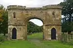 Gatehouse 120 Metres North East of Kirkleatham Hall Farm |
| Kirkleatham Hall Farm | Kirkleatham, Redcar and Cleveland | Tack Room | c. 1800 | 23 June 1952 | NZ5952821919 54°35′20″N 1°04′49″W |
1160085 |  Kirkleatham Hall Farm |
| Listening Post 330 Metres of Wheatlands Farmhouse | Redcar and Cleveland | Wall | c. 1916 | 13 May 1986 | NZ6148222954 54°35′53″N 1°03′00″W |
1160275 |  Listening Post 330 Metres of Wheatlands Farmhouse |
| Manor House | Redcar and Cleveland | House | c. 1716 | 22 June 1967 | NZ5447518295 54°33′25″N 1°09′33″W |
1310999 |  Manor House |
| Old Hall Farmhouse and Garden Wall | Lackenby, Redcar and Cleveland | Farmhouse | Mid 17th century | 29 April 1988 | NZ5650319397 54°34′00″N 1°07′39″W |
1139659 |  Old Hall Farmhouse and Garden Wall |
| Old Hall Museum | Kirkleatham, Redcar and Cleveland | School | 18th century | 14 June 1952 | NZ5922321637 54°35′11″N 1°05′06″W |
1139641 |  Old Hall Museum |
| Red Barns House and Red Barns Hotel | Redcar and Cleveland | House | 1868-70 | 29 April 1988 | NZ5966824923 54°36′57″N 1°04′39″W |
1139613 |  Red Barns House and Red Barns Hotel |
| Statue of Justice in Courtyard of Sir William Turners Hospital | Kirkleatham, Redcar and Cleveland | Statue | c. 1720 | 29 April 1988 | NZ5930521580 54°35′09″N 1°05′02″W |
1310769 |  Statue of Justice in Courtyard of Sir William Turners Hospital |
| West Lodges with Gates Gatepiers and Flanking Walls | Redcar and Cleveland | Gate | Mid 18th century | 5 May 1952 | NZ5209916911 54°32′41″N 1°11′46″W |
1329638 | 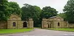 West Lodges with Gates Gatepiers and Flanking Walls |

Notes
- The date given is the date used by Historic England as significant for the initial building or that of an important part in the structure's description.
- Sometimes known as OSGB36, the grid reference is based on the British national grid reference system used by the Ordnance Survey.
- The "List Entry Number" is a unique number assigned to each listed building and scheduled monument by Historic England.
External links
![]() Media related to Grade II* listed buildings in Redcar and Cleveland at Wikimedia Commons
Media related to Grade II* listed buildings in Redcar and Cleveland at Wikimedia Commons
This article is issued from Wikipedia. The text is licensed under Creative Commons - Attribution - Sharealike. Additional terms may apply for the media files.