Grade II* listed buildings in Selby (district)
There are over 20,000 Grade II* listed buildings in England. This page is a list of these buildings in the district of Selby in North Yorkshire.
Selby
| Name | Location | Type | Completed [note 1] | Date designated | Grid ref.[note 2] Geo-coordinates |
Entry number [note 3] | Image |
|---|---|---|---|---|---|---|---|
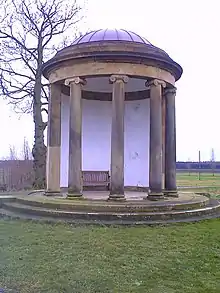
| Garden Temple | Escrick, North Yorkshire | Temple | 18th or 19th century | 10 April 1986 | SE 63647 41116 53°51′46″N 1°02′01″W |
1148453 | |
| Gatehouse | Bolton Percy, Selby | Gatehouse | 15th century | 29 January 1980 | SE5314841241 53°51′53″N 1°11′36″W |
1148416 |  Gatehouse |
| Church of St Mary (Roman Catholic) | Carlton, Selby | Roman Catholic Church | 1842 | 11 November 1993 | SE6476624310 53°42′40″N 1°01′13″W |
1148399 | 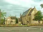 Church of St Mary (Roman Catholic) |
| The Grange | Cawood, Selby | House | 18th century | 17 November 1966 | SE5763137490 53°49′50″N 1°07′33″W |
1132512 |  |
| Yew Tree House and Yew Tree Cottage | Cawood, Selby | House | Mid-Late 17th century | 17 November 1966 | SE5763137638 53°49′55″N 1°07′33″W |
1132509 | |
| Holmes House | South Duffield, Cliffe, Selby | House | Early 17th century | 17 November 1966 | SE6965832598 53°47′06″N 0°56′39″W |
1148486 | 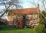 Holmes House |
| Church of St Helen | Escrick, Selby | Church | 1857 | 17 November 1966 | SE6280543127 53°52′50″N 1°02′46″W |
1167966 | 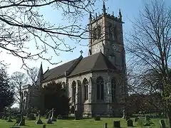 Church of St Helen |
| Coach House and Stables to rear of Escrick Park | Escrick, Selby | School | 1763 | 10 April 1986 | SE6320842346 53°52′25″N 1°02′24″W |
1148489 | |
| Escrick Park | Escrick, Selby | Country House | c1680 - 1690 | 25 October 1951 | SE6319142283 53°52′22″N 1°02′25″W |
1167878 | |
| Gateforth Hall | Gateforth, Selby | House | 1814 | 23 August 1978 | SE5559829562 53°45′34″N 1°09′29″W |
1132514 | 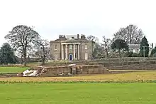 Gateforth Hall |
| Grimston Park | Grimston, Selby | Country House | Early 18th century | 4 July 1952 | SE4983741208 53°51′53″N 1°14′37″W |
1168029 | |
| Church of St John (previously St Helen) | Healaugh, Selby | Parish Church | 12th century | 12 July 1985 | SE4984947913 53°55′30″N 1°14′33″W |
1316655 | 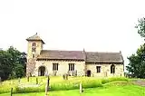 Church of St John (previously St Helen) |
| Healaugh Priory | Healaugh, Selby | House | c. 1540 | 12 July 1985 | SE4857546349 53°54′40″N 1°15′43″W |
1316677 | |
| Church of St Paul | Hensall, Selby | Church | 1854 | 11 December 1967 | SE5829322596 53°41′48″N 1°07′07″W |
1295734 | 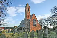 Church of St Paul |
| The Red House | Hensall, Selby | House | 1854 | 11 December 1967 | SE5824622561 53°41′47″N 1°07′10″W |
1148401 | |
| Chapel to Huddleston Hall, now a Barn, about 4m to west of House | Huddleston with Newthorpe, Selby | Chapel | 15th century | 3 February 1967 | SE4664233979 53°48′00″N 1°17′36″W |
1167970 | |
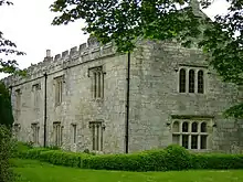
| Huddleston Hall | Huddleston with Newthorpe, Selby | Manor House | Late 16th century | 4 July 1952 | SE4666633979 53°48′00″N 1°17′35″W |
1167923 | .jpg.webp) Huddleston Hall |
| Stables to Huddleston Hall about 1 metre South East of House | Huddleston with Newthorpe, Selby | Stable | Late 16th century | 4 July 1952 | SE4667333946 53°47′59″N 1°17′34″W |
1167953 | |
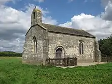
| Church of St Peter | Kirk Smeaton, Selby | Church | 12th century | 25 March 1968 | SE5201116638 53°38′37″N 1°12′53″W |
1316345 | 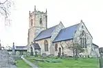 Church of St Peter |
| Church of St John the Baptist | Kirkby Wharfe with North Milford, Selby | Church | pre Conquest | 3 February 1967 | SE5060841071 53°51′48″N 1°13′55″W |
1148423 | 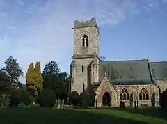 Church of St John the Baptist |
| Chapel of St Mary | Lead, Selby | Chapel | 12th century | 3 February 1967 | SE4642836896 53°49′35″N 1°17′46″W |
1148440 | |
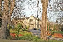
| Monk Fryston Hall | Monk Fryston, Selby | House | 13th century | 18 January 1952 | SE5061629855 53°45′45″N 1°14′01″W |
1148544 | |
| Prebendal House | Monk Fryston, Selby | House | c. 1425 | 11 December 1967 | SE5050329709 53°45′41″N 1°14′07″W |
1296762 | |
| Newton Kyme Hall | Newton Kyme cum Toulston, Selby | Country House | 17th century | 4 July 1952 | SE4654144908 53°53′54″N 1°17′36″W |
1132467 | 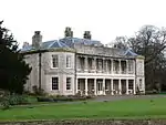 Newton Kyme Hall |
| The Manor House | Riccall, Selby | House | c. 1480 | 25 October 1951 | SE6157638077 53°50′07″N 1°03′57″W |
1172683 | |
| Abbots Staith Buildings | Selby | Shop | Late 17th century or early 18th century | 16 December 1952 | SE6158932555 53°47′08″N 1°04′00″W |
1167663 | 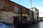 Abbots Staith Buildings |
| Corunna House | Selby | House | Early 18th century | 16 December 1952 | SE6166632458 53°47′05″N 1°03′56″W |
1132559 | 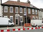 Corunna House |
| Skipwith Hall | Skipwith, Selby | House | Early 18th century | 25 October 1951 | SE6596838522 53°50′20″N 0°59′56″W |
1172750 | .jpg.webp) Skipwith Hall |
| The Old Stable Court to Stapleton Park | Stapleton, Selby | Stable | c. 1762 | 11 December 1967 | SE5067619296 53°40′04″N 1°14′04″W |
1316346 | |
| Steeton Hall Farm | Steeton, Selby | House | c. 1494 | 12 July 1985 | SE5330344237 53°53′30″N 1°11′26″W |
1301050 | |
| Moreby Hall | Stillingfleet, Selby | Country House | 1828-1832 | 17 November 1966 | SE5961843227 53°52′55″N 1°05′40″W |
1148506 | |
| Church of St Mary | Tadcaster, Selby | Church | Early C14-Early 15th century | 12 July 1985 | SE4859343507 53°53′08″N 1°15′44″W |
1167462 | 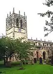 Church of St Mary |
| The Ark | Tadcaster, Selby | House | 15th century | 4 July 1952 | SE4858043397 53°53′04″N 1°15′45″W |
1167475 | .jpg.webp) The Ark |
| The Old Vicarage | Tadcaster, Selby | Hall House | Late 13th century | 18 May 1992 | SE4853843383 53°53′04″N 1°15′47″W |
1132450 | |
| Old Hall Farmhouse | Walden Stubbs, Selby | Farmhouse | 17th century | 25 March 1968 | SE5488616861 53°38′43″N 1°10′16″W |
1174475 | |
| Womersley Park and adjoining Coach-house and Stables | Womersley, Selby | Country House | 17th century | 1 December 1967 | SE5329418985 53°39′53″N 1°11′42″W |
1316344 | |


Notes
- The date given is the date used by Historic England as significant for the initial building or that of an important part in the structure's description.
- Sometimes known as OSGB36, the grid reference is based on the British national grid reference system used by the Ordnance Survey.
- The "List Entry Number" is a unique number assigned to each listed building and scheduled monument by Historic England.
External links
![]() Media related to Grade II* listed buildings in Selby District at Wikimedia Commons
Media related to Grade II* listed buildings in Selby District at Wikimedia Commons
This article is issued from Wikipedia. The text is licensed under Creative Commons - Attribution - Sharealike. Additional terms may apply for the media files.