Grade II* listed buildings in South Staffordshire
There are over 20,000 Grade II* listed buildings in England. This page is a list of these buildings in the district of South Staffordshire in Staffordshire.
South Staffordshire
| Name | Location | Type | Completed [note 1] | Date designated | Grid ref.[note 2] Geo-coordinates |
Entry number [note 3] | Image |
|---|---|---|---|---|---|---|---|
| Sandfields Pumping Station, East Building | Chesterfield Road, Lichfield, Staffordshire | Public Utility, Waterworks | c. 1872 | 1 December 2014 | SK1126508440 52°40′25″N 1°50′05″W |
1187742 | 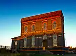 Sandfields Pumping Station, East Building |
| Church of St James | Acton Trussell, South Staffordshire | Parish Church | c. 1300 | 19 March 1962 | SJ9373217455 52°45′17″N 2°05′40″W |
1374077 | 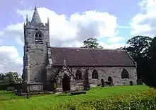 Church of St James |
| Church of the Holy Cross | Bobbington, South Staffordshire | Parish Church | 12th century | 27 June 1963 | SO8081090550 52°30′45″N 2°17′03″W |
1230544 | .jpg.webp) Church of the Holy Cross |
| The Blakelands and Attached Garden Wall Railings and Gate | Bobbington, South Staffordshire | House | 1722 | 16 June 1953 | SO8210991580 52°31′18″N 2°15′54″W |
1230535 |  |
| Black Ladies | Brewood and Coven, South Staffordshire | Country House | Late 16th century or early 17th century | 16 May 1953 | SJ8475909332 52°40′53″N 2°13′37″W |
1039336 | |
| Garden Walls to East, North and South of Black Ladies, with Gate Piers | Brewood and Coven, South Staffordshire | Gate Pier | 18th century | 16 May 1953 | SJ8478309306 52°40′52″N 2°13′35″W |
1039337 | |
| Dovecote in Centre of Coach House and Stable Courtyard | Chillington Park, Brewood and Coven, South Staffordshire | Dovecote | c. 1730 | 16 May 1963 | SJ8614706880 52°39′34″N 2°12′22″W |
1295254 | 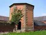 Dovecote in Centre of Coach House and Stable Courtyard |
| Payne's Bridge | Chillington Park, Brewood and Coven, South Staffordshire | Ornamental Bridge | Late 18th century | 16 May 1953 | SJ8581705695 52°38′56″N 2°12′40″W |
1060195 | 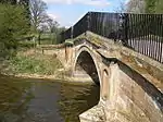 Payne's Bridge |
| Sham Bridge | Chillington Park, Brewood and Coven, South Staffordshire | Bridge | Late 18th century | 16 May 1953 | SJ8535506494 52°39′21″N 2°13′05″W |
1060196 | |
| Stable and Coach House Range (now partly Farm Buildings) | Chillington Park, Brewood and Coven, South Staffordshire | Animal House | Early 18th century | 28 March 1985 | SJ8615606905 52°39′35″N 2°12′22″W |
1060193 |  Stable and Coach House Range (now partly Farm Buildings) |
| The Bowling Green Arch and Gates | Chillington Park, Brewood and Coven, South Staffordshire | Gate | c. 1730 | 19 March 1962 | SJ8628606777 52°39′31″N 2°12′15″W |
1060192 | |
| The Whitehouse and Farm Building to east,west and south | Chillington Park, Brewood and Coven, South Staffordshire | Farmhouse | Early to mid 18th century | 16 May 1953 | SJ8597205142 52°38′38″N 2°12′32″W |
1039320 | |
| Shropshire Union Canal Belvide Round House and Retaining Wall, Belvide Reservoir, at SJ 869103 | Brewood and Coven, South Staffordshire | Valve House | 1827-1835 | 26 March 1993 | SJ8690010300 52°41′25″N 2°11′43″W |
1252181 | |
| Somerford Hall | Somerford Park, Brewood and Coven, South Staffordshire | Country House | Mid 18th century | 16 May 1953 | SJ8980908750 52°40′35″N 2°09′08″W |
1039352 | |
| Westgate, Forecourt Wall and Gate Piers | Brewood and Coven, South Staffordshire | House | 1723 | 16 May 1953 | SJ8832108600 52°40′30″N 2°10′27″W |
1060202 | |
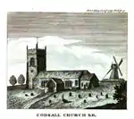
| Church of St Nicholas | Codsall, South Staffordshire | Parish Church | 12th century | 27 June 1963 | SJ8661804051 52°38′03″N 2°11′57″W |
1374035 | |
| Church of St Lawrence | Coppenhall, South Staffordshire | Parish Church | Early 13th century | 2 January 1986 | SJ9077519409 52°46′20″N 2°08′17″W |
1178330 | |
| Church of St Mary | Enville, Staffordshire | Parish Church | 12th century | 27 June 1963 | SO8236886836 52°28′45″N 2°15′40″W |
1230632 | 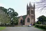 Church of St Mary |
| Stable Court at Four Ashes Hall | Four Ashes, Staffordshire | Garage | C20 | 6 May 1994 | SO7998087738 52°29′14″N 2°17′47″W |
1277027 | |
| The Museum | Enville Hall, Enville, South Staffordshire | Summerhouse | c. 1750 | 27 June 1963 | SO8231786347 52°28′29″N 2°15′42″W |
1278514 | |
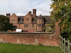
| Moseley Old Hall and Attached Garden Walls, Gatepiers and Gate | Featherstone, Staffordshire | House | c. 1870 | 16 May 1953 | SJ9316904415 52°38′15″N 2°06′09″W |
1039208 | Jul2006.jpg.webp) Moseley Old Hall and Attached Garden Walls, Gatepiers and Gate |
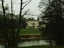
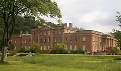
| Himley Hall | Himley Park, Himley, South Staffordshire | Country House | Early 18th century | 16 June 1953 | SO8882491561 52°31′19″N 2°09′58″W |
1230781 | |
| Whittington Inn | Whittington, Kinver, South Staffordshire | House | Medieval | 16 June 1953 | SO8568582823 52°26′35″N 2°12′43″W |
1277300 | .jpg.webp) Whittington Inn |
| Church of St John | Stretton, Lapley, Stretton and Wheaton Aston | Parish Church | 12th century | 19 March 1962 | SJ8867411667 52°42′09″N 2°10′09″W |
1374085 | |
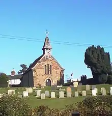
| Church of St Mary | Wheaton Aston | Church | 1857 | 4 July 1985 | SJ8516612554 52°42′38″N 2°13′16″W |
1180167 | 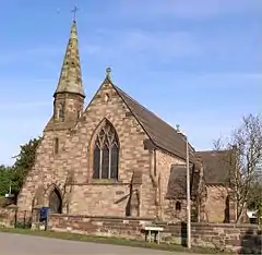 Church of St Mary |
| Longnor Hall, attached Wall to North East, and Gate Piers | Longnor, Lapley, Stretton and Wheaton Aston, South Staffordshire | Country House | 1726 | 19 March 1962 | SJ8672814137 52°43′29″N 2°11′53″W |
1039251 | 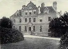 Longnor Hall, attached Wall to North East, and Gate Piers |
| Stretton Hall and combined Service and Stable Wing | Lapley, Stretton and Wheaton Aston, South Staffordshire | Country House | 1720s | 16 May 1953 | SJ8870211723 52°42′11″N 2°10′07″W |
1180222 | .jpg.webp) Stretton Hall and combined Service and Stable Wing |
| Church of St Chad | Pattingham and Patshull, South Staffordshire | Parish Church | 12th century | 27 June 1963 | SO8209699140 52°35′23″N 2°15′57″W |
1188526 | 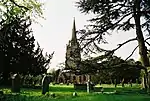 Church of St Chad |
| Church of St Mary | Patshull Park, Pattingham and Patshull, South Staffordshire | Parish Church | c. 1743 | 27 June 1963 | SJ8006700668 52°36′12″N 2°17′45″W |
1039330 | |
| Flanking Ranges, Walls and Gate Piers to Service Courtyard North West of Patshull Hall | Patshull Park, Pattingham and Patshull, South Staffordshire | Gate Pier | Mid 18th century | 28 March 1985 | SJ8017600928 52°36′21″N 2°17′39″W |
1294886 | |
| Principal Terrace to South of Patshull Hall, Steps to East and West and Tower to East and West | Patshull Park, Pattingham and Patshull, South Staffordshire | Steps | Mid 18th century | 28 March 1985 | SJ8030000894 52°36′20″N 2°17′32″W |
1188162 | |
| Screen, Gates, Walls and 2 Arches to Outer Forecourt of Patshull Hall | Patshull Park, Pattingham and Patshull, South Staffordshire | Gate | 18th century | 16 June 1953 | SJ8022900998 52°36′23″N 2°17′36″W |
1374040 | 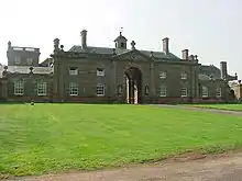 Screen, Gates, Walls and 2 Arches to Outer Forecourt of Patshull Hall |
| The Temple | Patshull Park, Pattingham and Patshull, South Staffordshire | Garden Temple | Mid to late 18th century | 24 March 1977 | SO8005299663 52°35′40″N 2°17′45″W |
1374062 | |
| Pillaton Old Hall | Pillaton, Penkridge, South Staffordshire | Moat | 1488 | 16 May 1953 | SJ9424112940 52°42′51″N 2°05′12″W |
1039189 | .jpg.webp) Pillaton Old Hall |
| The Old Deanery | Penkridge, South Staffordshire | House | 17th century | 19 March 1962 | SJ9210414237 52°43′33″N 2°07′06″W |
1039192 | |
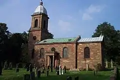
| Church of St Mary and St Luke | Shareshill, South Staffordshire | Church | 18th century | 19 March 1962 | SJ9443706589 52°39′25″N 2°05′01″W |
1374120 | 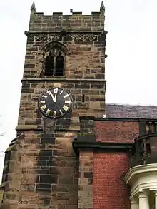 Church of St Mary and St Luke |
| Building Containing Mill Wheel at Teddesley Home Farm | Teddesley Hay, South Staffordshire | Engine House | c. 1837 | 19 October 1998 | SJ9515616110 52°44′33″N 2°04′23″W |
1385728 | |
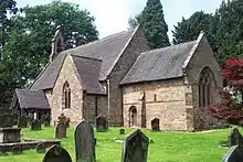
| Church of All Saints | Trysull, South Staffordshire | Parish Church | 12th century | 27 June 1963 | SO8520694263 52°32′46″N 2°13′11″W |
1232253 | 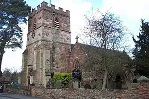 Church of All Saints |
| Coach House and Stable Block at the Wodehouse | Wombourne, South Staffordshire | Stable | Early 18th century | 27 June 1963 | SO8861693725 52°32′29″N 2°10′09″W |
1277064 | |
| Lloyd House | Wombourne, South Staffordshire | House | Post 1799 | 16 June 1953 | SO8875194437 52°32′52″N 2°10′02″W |
1232503 | .jpg.webp) Lloyd House |
| The Bratch Water Pumping Station | Wombourne, South Staffordshire | Water Pumping Station | Dated 1895 | 9 October 1980 | SO8682993727 52°32′28″N 2°11′44″W |
1232411 | 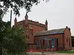 The Bratch Water Pumping Station |
| The Wodehouse | Wombourne, South Staffordshire | House | 17th century | 16 June 1953 | SO8860293522 52°32′22″N 2°10′10″W |
1232507 | |
| Wodehouse Farmhouse and Mill | Wombourne, South Staffordshire | Farmhouse | Early 18th century | 10 January 1973 | SO8854793537 52°32′22″N 2°10′13″W |
1277065 | |
Notes
- The date given is the date used by Historic England as significant for the initial building or that of an important part in the structure's description.
- Sometimes known as OSGB36, the grid reference is based on the British national grid reference system used by the Ordnance Survey.
- The "List Entry Number" is a unique number assigned to each listed building and scheduled monument by Historic England.
External links
![]() Media related to Grade II* listed buildings in Staffordshire at Wikimedia Commons
Media related to Grade II* listed buildings in Staffordshire at Wikimedia Commons
This article is issued from Wikipedia. The text is licensed under Creative Commons - Attribution - Sharealike. Additional terms may apply for the media files.