Grade II* listed buildings in Tandridge (district)
There are over 20,000 Grade II* listed buildings in England. This page is a list of the 52 Grade II* listed buildings in the district of Tandridge in Surrey. For links to similar articles in relation to the other 10 districts of Surrey see Grade II* listed buildings in Surrey.
| Name | Location | Type | Completed [note 1] | Date designated | Grid ref.[note 2] Geo-coordinates |
Entry number [note 3] | Image |
|---|---|---|---|---|---|---|---|
| King Charles Cottage Restaurant | Bletchingley, Tandridge District | House | 19th century | 11 June 1958 | TQ3272150790 51°14′27″N 0°06′00″W |
1029976 |  |
| Place Farm House including Cleves Cottage | Bletchingley, Tandridge | House | 16th century | 11 June 1958 | TQ3266252121 51°15′10″N 0°06′02″W |
1029989 | |
| The Hawthorns (Pendell Court) | Bletchingley, Tandridge | House/School | 1624 | 11 June 1958 | TQ3170651889 51°15′03″N 0°06′51″W |
1281104 | 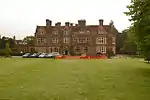 The Hawthorns (Pendell Court) |
| The Manor House | Bletchingley, Tandridge | House | Late 18th century | 11 June 1958 | TQ3160951718 51°14′58″N 0°06′56″W |
1204686 | |
| The Whyte Harte Inn including Former Stable to Rear | Bletchingley, Tandridge | Inn | 16th century | 11 June 1958 | TQ3274550748 51°14′26″N 0°05′59″W |
1377531 | .jpg.webp) The Whyte Harte Inn including Former Stable to Rear |
| 42–44 High Street | Bletchingley, Tandridge | House | 18th century | 11 June 1958 | TQ3270850786 51°14′27″N 0°06′01″W |
1204531 | |
| Burstow Lodge | Burstow, Tandridge | House | C15 | 11 June 1958 | TQ3147144189 51°10′55″N 0°07′13″W |
1204768 | .jpg.webp) Burstow Lodge |
| Crullings & Smallfield Place | Burstow, Tandridge | House | c. 1600 | 11 June 1958 | TQ3267043173 51°10′21″N 0°06′13″W |
1029963 | |
| Chaldon Court | Chaldon, Tandridge | Timber Framed House | 14th century | 21 September 1954 | TQ3082055676 51°17′07″N 0°07′32″W |
1029812 | |
| Tollsworth Manor House | Chaldon, Tandridge | House | 17th century | 21 September 1954 | TQ3059954595 51°16′32″N 0°07′45″W |
1029822 | |
| Beddlestead House | Chelsham, Chelsham and Farleigh, Tandridge | House | Early 19th century | 11 June 1958 | TQ3986657739 51°18′06″N 0°00′18″E |
1029796 | %252C_Chelsham%252C_CR6_-_geograph.org.uk_-_53381.jpg.webp) Beddlestead House |
| Granary and Barn 15 Yards South West of Crowhurst Place | Crowhurst, Tandridge | Granary | 15th century | 9 March 1982 | TQ3859546336 51°11′58″N 0°01′04″W |
1377584 | |
| Mansion House Farm House | Crowhurst, Tandridge | House | 17th century | 11 June 1958 | TQ3911847414 51°12′32″N 0°00′35″W |
1029930 | .jpg.webp) Mansion House Farm House |
| Dwelly Farm House | Dormansland, Tandridge | Farmhouse | late C16/early 17th century | 11 February 1958 | TQ4170946000 51°11′44″N 0°01′36″E |
1029914 | |
| Hoopers Farm House | Dormansland, Tandridge | Farmhouse | 19th century | 11 June 1958 | TQ4269942788 51°10′00″N 0°02′23″E |
1205719 | |
| Puttenden Manor House | Dormansland, Tandridge | House | 17th century | 11 June 1958 | TQ4088145477 51°11′28″N 0°00′53″E |
1280736 | .jpg.webp) Puttenden Manor House |
| Starborough Castle Walls and Garden House | Dormansland, Tandridge | Castle | 1754 | 11 June 1958 | TQ4260744120 51°10′43″N 0°02′20″E |
1205666 | |
| Lagham Manor | Godstone, Tandridge | Manor House | 16th century | 11 June 1958 | TQ3636448055 51°12′56″N 0°02′56″W |
1029769 | |
| St Mary's Almshouses and Chapel of St Mary | Godstone, Tandridge | Jettied House | 1872 | 11 June 1958 | TQ3569851465 51°14′46″N 0°03′26″W |
1188470 | .jpg.webp) St Mary's Almshouses and Chapel of St Mary |
| The Bell Hotel | Godstone, Tandridge | House | c. 1700 | 11 June 1958 | TQ3509151467 51°14′47″N 0°03′57″W |
1029779 | 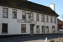 The Bell Hotel |
| The Old Packhouse | Godstone, Tandridge | House | Late 16th century | 11 June 1958 | TQ3571051096 51°14′34″N 0°03′26″W |
1294724 | |
| The White Hart | Godstone, Tandridge | Restaurant | 16th century | 11 June 1958 | TQ3505951557 51°14′50″N 0°03′59″W |
1188625 | 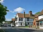 The White Hart |
| Church of St Mary the Virgin | Horne, Tandridge | Church | 14th century | 11 June 1958 | TQ3368544349 51°10′58″N 0°05′19″W |
1377549 | .JPG.webp) Church of St Mary the Virgin |
| Lowlands Farm House | Horne, Tandridge | House | 16th century | 25 April 1984 | TQ3635942407 51°09′53″N 0°03′04″W |
1205065 | |
| Batchelors Farm House | Limpsfield, Tandridge | Farmhouse | 15th century | 19 November 1984 | TQ4262448469 51°13′03″N 0°02′27″E |
1188980 | |
| Court Cottage | Limpsfield, Tandridge | Row | 16th century and 17th century | 11 June 1958 | TQ4055753090 51°15′35″N 0°00′47″E |
1188723 | |
| Detillens Cottage | Limpsfield, Tandridge | House | C20 | 11 June 1958 | TQ4056853096 51°15′35″N 0°00′47″E |
1377656 | |
| Detillens House | Limpsfield, Tandridge | House | 1736 | 11 June 1958 | TQ4057353067 51°15′34″N 0°00′48″E |
1377657 | .jpg.webp) Detillens House |
| Friars Cottage | Pains Hill, Limpsfield, Tandridge | House | C20 | 11 June 1958 | TQ4114851719 51°14′50″N 0°01′15″E |
1377660 | |
| Miles Butchers Shop and Dentists Surgery | Limpsfield, Tandridge | Cross Wing House | 15th century | 11 June 1958 | TQ4059453050 51°15′33″N 0°00′49″E |
1188829 | |
| Pebble Mill House Including Rangers Cottage to Rear | Limpsfield, Tandridge | House | c. 1776 | 11 June 1958 | TQ4087652731 51°15′23″N 0°01′03″E |
1029730 | |
| Tenchleys Manor | Itchingwood Common, Limpsfield, Tandridge | House | 1599 (Dendrochronology report) | 11 June 1958 | TQ4215250980 51°14′25″N 0°02′06″E |
1029762 | 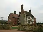 Tenchleys Manor |
| The Moat Farm House including Barn Attached to Right | Limpsfield, Tandridge | House | Late 16th century | 11 June 1958 | TQ4252250697 51°14′16″N 0°02′25″E |
1029763 | |
| Church House & Star Inn Cottages | Lingfield, Tandridge | House | 16th century | 11 June 1958 | TQ3892243734 51°10′34″N 0°00′50″W |
1205173 | |
| Magnus Deo | Lingfield, Tandridge | House | 18th century | 11 June 1958 | TQ3858243527 51°10′27″N 0°01′08″W |
1205825 | |
| New Place | Lingfield, Tandridge | House | 1617 | 11 June 1958 | TQ3928643745 51°10′34″N 0°00′32″W |
1280486 | .jpg.webp) New Place |
| Old Town House and Old Town Cottage | Lingfield, Tandridge | House | 17th century | 11 June 1958 | TQ3889643739 51°10′34″N 0°00′52″W |
1029910 | |
| The College including former Kitchen to South West | Lingfield, Tandridge | College | c. 1700 | 11 June 1958 | TQ3883543778 51°10′35″N 0°00′55″W |
1205289 | |
| The Garth | Lingfield, Tandridge | House | 1729 | 11 June 1958 | TQ3807043666 51°10′32″N 0°01′34″W |
1205754 | |
| The Guest House (The Library) | Lingfield, Tandridge | House/Library | C20 | 11 June 1958 | TQ3887643828 51°10′37″N 0°00′53″W |
1205909 | .jpg.webp) The Guest House (The Library) |
| The Old House | Lingfield, Tandridge | House | 17th century | 22 March 1973 | TQ3837243841 51°10′37″N 0°01′19″W |
1205370 | |
| Church of St Peter and St Paul | Nutfield, Tandridge | Church | 13th century | 11 June 1958 | TQ3092050870 51°14′31″N 0°07′33″W |
1377573 | .JPG.webp) Church of St Peter and St Paul |
| Cogmans Farm House | Outwood, Tandridge | Base Cruck House | 15th century | 11 June 1958 | TQ3248044571 51°11′06″N 0°06′21″W |
1377560 | |
| Mayflower Cottage | Broadham Green, Oxted, Tandridge | Hall House | 15th century | 11 June 1958 | TQ3886051194 51°14′35″N 0°00′43″W |
1189581 | |
| Stocketts Manor | Oxted, Tandridge | House | 17th century | 11 June 1958 | 49°46′01″N 7°33′26″W | 1189612 | .jpg.webp) Stocketts Manor |
| The Old Bell Inn | Oxted, Tandridge | Inn | 16th century | 11 June 1958 | TQ3848552230 51°15′09″N 0°01′01″W |
1189620 | 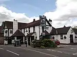 The Old Bell Inn |
| The Old Cottage | Broadham Green, Oxted, Tandridge | House | 19th century | 11 June 1958 | TQ3870051150 51°14′34″N 0°00′52″W |
1029734 | |
| Hobbs Farm House | Tandridge, Tandridge | Farmhouse | 17th century | 11 June 1958 | TQ3754047377 51°12′33″N 0°01′57″W |
1029716 | |
| The Red Barn | Tandridge, Tandridge | House | 17th century | 11 June 1958 | TQ3703145232 51°11′24″N 0°02′26″W |
1189853 | |
| Church of St James the Greater | Titsey, Tandridge | Former Church | 1861 | 11 June 1958 | TQ4091354975 51°16′35″N 0°01′08″E |
1294053 | .JPG.webp) Church of St James the Greater |
| Church of All Saints | Warlingham, Tandridge | Church | 13th century | 21 September 1954 | TQ3557858960 51°18′49″N 0°03′22″W |
1188033 | .JPG.webp) Church of All Saints |
| The Vicarage | Warlingham, Tandridge | House | c. 1674 | 21 September 1954 | TQ3553158414 51°18′31″N 0°03′25″W |
1029794 | |
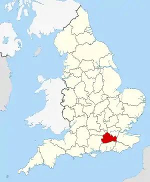
Surrey shown within England
Notes
- The date given is the date used by Historic England as significant for the initial building or that of an important part in the structure's description.
- Sometimes known as OSGB36, the grid reference is based on the British national grid reference system used by the Ordnance Survey.
- The "List Entry Number" is a unique number assigned to each listed building and scheduled monument by Historic England.
References
External links
![]() Media related to Grade II* listed buildings in Surrey at Wikimedia Commons
Media related to Grade II* listed buildings in Surrey at Wikimedia Commons
This article is issued from Wikipedia. The text is licensed under Creative Commons - Attribution - Sharealike. Additional terms may apply for the media files.