Grade II* listed buildings in Waverley, Surrey
There are over 20,000 Grade II* listed buildings in England. This page is a list of the 95 Grade II* listed buildings in the district of Waverley in Surrey. For similar lists in respect of the other ten districts of Surrey see Grade II* listed buildings in Surrey.
Surrey shown within England
There are 95 Grade II* listed buildings in Waverley, with the largest number, 44, in the town of Farnham which is one of three towns in the district. Castle Street there has 17 Grade II* listed buildings, leading to architectural historian Alec Clifton-Taylor to say that "for sheer visual delight, this street has few equals in all England".[1]
| Name | Location | Type | Completed [note 1] | Date designated | Grid ref.[note 2] Geo-coordinates |
Entry number [note 3] | Image |
|---|---|---|---|---|---|---|---|
| Alfold House | Alfold, Waverley | House | 17th century | 9 March 1960 | TQ0398034099 51°05′48″N 0°30′59″W |
1044391 |  |
| Alfold Stores & the Magnolias | Alfold, Waverley | House | Late 19th century | 28 September 1987 | TQ0390734031 51°05′46″N 0°31′03″W |
1044392 | |
| Church of St Andrew | Grafham, Bramley, Waverley | Church | 1861-4 | 28 October 1986 | TQ0229641659 51°09′54″N 0°32′18″W |
1249496 | 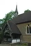 Church of St Andrew |
| East Manor House | Bramley, Waverley | House | 16th century LATER THAN c1540 | 9 March 1960 | TQ0105644510 51°11′27″N 0°33′19″W |
1249485 | 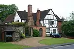 East Manor House |
| The Church of Holy Trinity | Bramley, Waverley | Church | Early 13th century | 9 March 1960 | TQ0087944907 51°11′40″N 0°33′28″W |
1044581 |  The Church of Holy Trinity |
| Barn 5 Yards South West of Skinners Land Farmhouse | Chiddingfold, Waverley | Barn | 19th century | 17 June 1983 | SU9682936372 51°07′06″N 0°37′05″W |
1248593 | |
| Carriage House/Implement Shed 3 Yards South of Combe Court Farm | Chiddingfold, Waverley | Dovecote | 1882 | 17 June 1983 | SU9416236107 51°06′59″N 0°39′22″W |
1248589 | |
| Combe Court Farm | Chiddingfold, Waverley | Hall House | 15th century | 17 June 1983 | SU9416536127 51°07′00″N 0°39′22″W |
1277813 | |
| Hadmans | Chiddingfold, Waverley | House | 16th century | 9 March 1960 | SU9621035564 51°06′41″N 0°37′37″W |
1044603 | 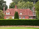 Hadmans |
| Lythe Hill Hotel | Chiddingfold, Waverley | Farmhouse | 15th century | 9 March 1960 | SU9241932494 51°05′04″N 0°40′55″W |
1277848 | 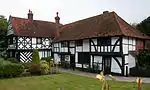 Lythe Hill Hotel |
| Pickhurst | Chiddingfold, Waverley | House | Later alteration | 17 June 1983 | SU9670834144 51°05′54″N 0°37′13″W |
1248585 | |
| Skinners Land Farmhouse | Chiddingfold, Waverley | House | C20 | 9 March 1960 | SU9682736389 51°07′07″N 0°37′05″W |
1277761 | |
| The Crown Inn | Chiddingfold, Waverley | House | Later alterations | 9 March 1960 | SU9605535366 51°06′34″N 0°37′45″W |
1044569 | 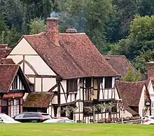 The Crown Inn |
| Church of St Nicholas | Cranleigh, Waverley | Tower | 14th century | 9 March 1960 | TQ0598639139 51°08′30″N 0°29′11″W |
1044371 | 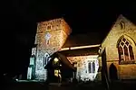 Church of St Nicholas |
| Elstead Mill | Elstead, Waverley | Mill House | 16th century | 9 March 1960 | SU9035643832 51°11′12″N 0°42′31″W |
1044454 | 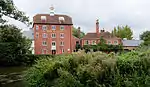 Elstead Mill |
| Church of St James | Westrook Hill, Elstead, Waverley | Church | 13th century | 9 March 1960 | SU9032943402 51°10′58″N 0°42′32″W |
1188415 | 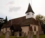 Church of St James |
| Marylands | Hurtwood, Ewhurst, Waverley | House | Between 1929 and 1931 | 10 May 1994 | TQ0829242008 51°10′01″N 0°27′09″W |
1253713 | |
| White Hart Cottage | Ewhurst, Waverley | House | 19th century | 12 September 1972 | TQ0906540749 51°09′20″N 0°26′31″W |
1044312 | 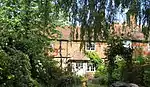 White Hart Cottage |
| Bethune House and Little House 88 and 88a West Street |
Farnham, Waverley | House | Late 18th century | 26 April 1950 | SU8364946735 51°12′49″N 0°48′14″W |
1243072 | 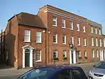 Bethune House and Little House 88 and 88a West Street |
| Castle Hill House 43 Castle Street |
Farnham, Waverley | House | Earlier | 26 April 1950 | SU8385447158 51°13′03″N 0°48′03″W |
1378286 | 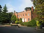 Castle Hill House 43 Castle Street |
| 1 and 2 Castle Street | Farnham, Waverley | Inn | Modern | 26 April 1950 | SU8396446887 51°12′54″N 0°47′57″W |
1044679 | 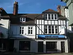 1 and 2 Castle Street |
| 73 and 74 Castle Street | Farnham, Waverley | House | 18th century | 26 April 1950 | SU8397146940 51°12′56″N 0°47′57″W |
1117389 | 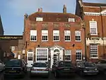 73 and 74 Castle Street |
| Elmer House 41 West Street |
Farnham, Waverley | House | Late 18th century | 26 April 1950 | SU8354746652 51°12′47″N 0°48′19″W |
1259093 | 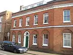 Elmer House 41 West Street |
| Garden Walls to Gardens East and North of the Grange | Farnham, Waverley | Wall and gates | Early 18th century | 29 December 1972 | SU8359347409 51°13′11″N 0°48′16″W |
1242145 | 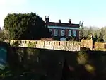 Garden Walls to Gardens East and North of the Grange |
| Guildford House 44 Castle Street |
Farnham, Waverley | House | Late 18th century | 26 April 1950 | SU8387647122 51°13′02″N 0°48′02″W |
1242416 | 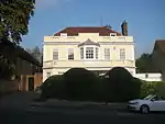 Guildford House 44 Castle Street |
| Hewetts Farmhouse | Farnham, Waverley | Farmhouse | 16th century to 17th century | 29 December 1972 | SU8714847938 51°13′26″N 0°45′12″W |
1259919 |  Hewetts Farmhouse |
| Ivy House (Conservative Club) | Farnham, Waverley | House | Later alteration | 26 April 1950 | SU8397546819 51°12′52″N 0°47′57″W |
1116718 | 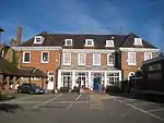 Ivy House (Conservative Club) |
| Moor Park House | Farnham, Waverley | House | 17th century | 26 April 1950 | SU8621646529 51°12′41″N 0°46′02″W |
1319854 | |
| 5 and 5a Castle Street | Farnham, Waverley | Stable/shop | Early to Mid 19th century | 29 December 1972 | SU8394346922 51°12′55″N 0°47′58″W |
1044681 | 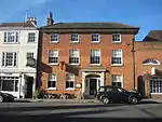 5 and 5a Castle Street |
| 67 and 68 Castle Street | Farnham, Waverley | Shop | Late 18th century to Mid 19th century | 26 April 1950 | SU8394446991 51°12′57″N 0°47′58″W |
1044662 | 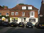 67 and 68 Castle Street |
| 76 Castle Street | Farnham, Waverley | House | Late 18th century | 29 December 1972 | SU8398346916 51°12′55″N 0°47′56″W |
1044622 | 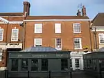 76 Castle Street |
| 35 and 36 The Borough | Farnham, Waverley | House/Shop | 1950 | 26 April 1950 | SU8400646875 51°12′54″N 0°47′55″W |
1044666 | 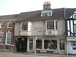 35 and 36 The Borough |
| Sandford House 39 West Street |
Farnham, Waverley | House | 18th century | 26 April 1950 | SU8357946670 51°12′47″N 0°48′17″W |
1258471 | 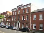 Sandford House 39 West Street |
| The Old Vicarage, Vicarage Lane | Farnham, Waverley | House | 16th century | 26 April 1950 | SU8384346614 51°12′45″N 0°48′04″W |
1273555 | 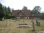 The Old Vicarage, Vicarage Lane |
| The Ranger's House, Farnham Park | Farnham Park, Farnham, Waverley | Rangers House | 18th century | 26 April 1950 | SU8414747892 51°13′27″N 0°47′47″W |
1378305 | 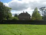 The Ranger's House, Farnham Park |
| 40 The Borough | Farnham, Waverley | House | C16-C17 | 26 April 1950 | SU8398046866 51°12′53″N 0°47′56″W |
1044671 | 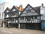 40 The Borough |
| Vernon House 28 West Street |
Farnham, Waverley | House | 16th century | 26 April 1950 | SU8367346711 51°12′49″N 0°48′12″W |
1258122 | 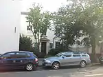 Vernon House 28 West Street |
| Waverley Abbey House | Farnham, Waverley | House | c. 1769 | 26 April 1950 | SU8683345547 51°12′09″N 0°45′31″W |
1258221 | 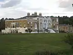 Waverley Abbey House |
| Weybourne House | Farnham, Waverley | House | 1724 | 26 April 1950 | SU8541448747 51°13′54″N 0°46′41″W |
1243152 | 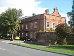 Weybourne House |
| William Cobbett Public House 4 Bridge Square |
Farnham, Waverley | Timber Framed House | 17th century | 26 April 1950 | SU8414846523 51°12′42″N 0°47′48″W |
1044674 | 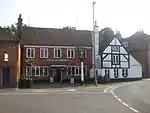 William Cobbett Public House 4 Bridge Square |
| Windsor Almshouses 53–60 Castle Street |
Farnham, Waverley | Steps | 1619 | 26 April 1950 | SU8391047051 51°12′59″N 0°48′00″W |
1242457 | 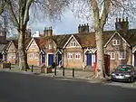 Windsor Almshouses 53–60 Castle Street |
| 70 Castle Street | Farnham, Waverley | House | 1775 | 26 April 1950 | SU8395446969 51°12′57″N 0°47′58″W |
1044663 | 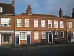 70 Castle Street |
| 3 Downing Street | Farnham, Waverley | House | 1717 | 26 April 1950 | SU8401146648 51°12′46″N 0°47′55″W |
1044634 | 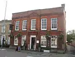 3 Downing Street |
| 62 Castle Street | Farnham, Waverley | House | 18th century | 26 April 1950 | SU8392947021 51°12′58″N 0°47′59″W |
1044660 | 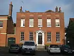 62 Castle Street |
| 9 Castle Street | Farnham, Waverley | House | 18th century | 26 April 1950 | SU8392446960 51°12′56″N 0°47′59″W |
1044683 | 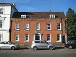 9 Castle Street |
| 45 Castle Street | Farnham, Waverley | House | Early 18th century | 26 April 1950 | SU8388147106 51°13′01″N 0°48′01″W |
1044656 | 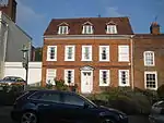 45 Castle Street |
| 43 The Borough | Farnham, Waverley | Shop | 1932 | 26 April 1950 | SU8396846856 51°12′53″N 0°47′57″W |
1044672 | 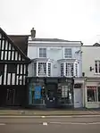 43 The Borough |
| 48, 49 and 50 Downing Street | Farnham, Waverley | Shop | Early 19th century | 26 April 1950 | SU8398046705 51°12′48″N 0°47′57″W |
1116966 | 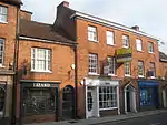 48, 49 and 50 Downing Street |
| 90 West Street | Farnham, Waverley | House | 18th century | 26 April 1950 | SU8367446745 51°12′50″N 0°48′12″W |
1243074 | 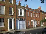 90 West Street |
| 6 and 7 Castle Street | Farnham, Waverley | Shop | 19th century | 26 April 1950 | SU8393346937 51°12′56″N 0°47′59″W |
1242274 | 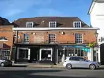 6 and 7 Castle Street |
| 89 West Street | Farnham, Waverley | House | Late 18th century | 26 April 1950 | SU8366446741 51°12′50″N 0°48′13″W |
1243073 | 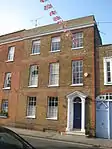 89 West Street |
| 10 Castle Street | Farnham, Waverley | House | Early 18th century | 26 April 1950 | SU8390246961 51°12′57″N 0°48′00″W |
1260093 | 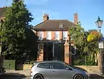 10 Castle Street |
| 23 and 24 West Street | Farnham, Waverley | House | 1790 | 26 April 1950 | SU8375746754 51°12′50″N 0°48′08″W |
1259743 | 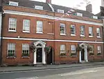 23 and 24 West Street |
| 104 West Street | Farnham, Waverley | House | 18th century | 26 April 1950 | SU8376846785 51°12′51″N 0°48′07″W |
1273042 | 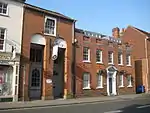 104 West Street |
| 91 and 92 West Street | Farnham, Waverley | House | Late 18th century | 26 April 1950 | SU8368446750 51°12′50″N 0°48′12″W |
1273060 | 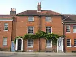 91 and 92 West Street |
| 4 Downing Street | Farnham, Waverley | House | c. 1800 | 26 April 1950 | SU8399246653 51°12′46″N 0°47′56″W |
1378277 | 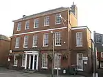 4 Downing Street |
| 71 Castle Street | Farnham, Waverley | House | Post 1772 | 26 April 1950 | SU8396046958 51°12′56″N 0°47′57″W |
1117386 | 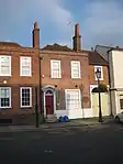 71 Castle Street |
| 61 Castle Street | Farnham, Waverley | House | Late 18th century | 26 April 1950 | SU8392147033 51°12′59″N 0°47′59″W |
1242623 | 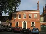 61 Castle Street |
| 12 and 13 Bridge Square | Farnham, Waverley | House | Late 18th century | 26 April 1950 | SU8409946525 51°12′42″N 0°47′51″W |
1260235 | 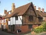 12 and 13 Bridge Square |
| 20, 20a and 21 West Street | Farnham, Waverley | House | 18th century | 26 April 1950 | SU8377546760 51°12′50″N 0°48′07″W |
1258391 | 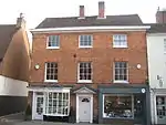 20, 20a and 21 West Street |
| 4 Castle Street | Farnham, Waverley | Shop | Early 19th century | 26 April 1950 | SU8394846911 51°12′55″N 0°47′58″W |
1378260 | 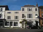 4 Castle Street |
| Church of St Mary the Virgin | Frensham, Waverley | Church | 13th century | 9 March 1960 | SU8419141444 51°09′58″N 0°47′50″W |
1044427 | 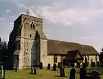 Church of St Mary the Virgin |
| Pierrepont (Ellel Ministries) | Frensham, Waverley | House | Earlier core | 3 May 1973 | SU8508942110 51°10′19″N 0°47′03″W |
1188515 | .jpg.webp) Pierrepont (Ellel Ministries) |
| Chapel at Charterhouse School | Godalming, Waverley | School Chapel | 1927 | 16 January 1981 | SU9649445015 51°11′46″N 0°37′13″W |
1352726 | 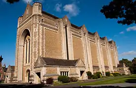 Chapel at Charterhouse School |
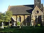
| Church of St John the Baptist | Busbridge, Godalming, Waverley | Church | 1865-7 | 23 February 1970 | SU9785542911 51°10′37″N 0°36′05″W |
1352706 | |
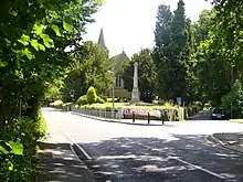
| Busbridge War Memorial | Busbridge | War memorial | 1922 | 1 February 1991 | SU9781142958 51°10′38″N 0°36′09″W |
1044531 | |
| 74, 74A, 76 & 76A High Street (Costa Coffee at 74) | Godalming, Waverley | Apartment/Shop | C20 | 18 December 1947 | SU9699943845 51°11′08″N 0°36′49″W |
1293929 | 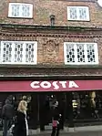 74, 74A, 76 & 76A High Street (Costa Coffee at 74) |
| Munstead Orchard | Busbridge, Godalming, Waverley | Timber Framed House | 1894 AND 1895 | 11 September 1987 | SU9798642835 51°10′35″N 0°35′59″W |
1294520 | |
| The Red House | Godalming, Waverley | House | 1899 | 23 February 1970 | SU9678244977 51°11′45″N 0°36′59″W |
1044519 | |
| Westbrook | Westbrook, Godalming, Waverley | Apartment | 1991 | 9 December 1988 | SU9611344264 51°11′22″N 0°37′34″W |
1299619 | |
| 80, High Street | Godalming, Godalming, Waverley | House/Shop | Mid-Late 17th century | 18 December 1947 | SU9698043844 51°11′08″N 0°36′50″W |
1293899 | 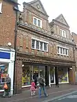 80, High Street |
| 99, 101 and 103 High Street | Godalming, Waverley | Shops | C20 | 18 December 1947 | SU9687443810 51°11′07″N 0°36′55″W |
1044526 | 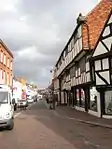 99, 101 and 103 High Street |
| Vann | Hambledon, Waverley | Farmhouse | AFTER 1520 BY 18th century | 9 March 1960 | SU9827137548 51°07′44″N 0°35′49″W |
1261120 | |
| Church of St Peter | Hascombe, Waverley | Church | 1864 | 28 October 1986 | TQ0018139542 51°08′47″N 0°34′09″W |
1240725 | 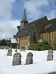 Church of St Peter |
| Amesbury School | Hindhead, Haslemere, Waverley | House | 1903 | 23 January 1973 | SU8809834345 51°06′06″N 0°44′35″W |
1272562 | 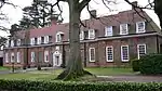 Amesbury School |
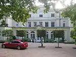
| Branksome Conference Centre | Haslemere, Waverley | Conference Centre | 1901 | 19 September 1977 | SU8850133512 51°05′39″N 0°44′15″W |
1244332 | 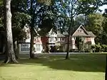 Branksome Conference Centre |
| Broad Dene | Haslemere, Waverley | Gabled House | 1900 | 11 August 1975 | SU9010632629 51°05′09″N 0°42′54″W |
1244326 | 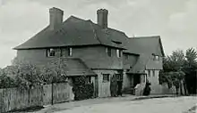 Broad Dene |
| Church Hill House | Haslemere, Waverley | House | Early 18th century | 3 December 1953 | SU9031433386 51°05′34″N 0°42′42″W |
1243900 | |
| Kemnal | Haslemere, Waverley | Gabled House | 1888 | 19 September 1977 | SU9081033397 51°05′34″N 0°42′17″W |
1243908 | |
| The White House | Grayswood, Haslemere, Waverley | House | 1930 | 28 January 1971 | SU9186334859 51°06′20″N 0°41′21″W |
1244056 | |
| Town House | Haslemere, Waverley | House | 18th century | 3 December 1953 | SU9056833075 51°05′23″N 0°42′29″W |
1244318 | 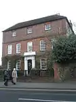 Town House |
| Tudor House | Haslemere, Waverley | Timber Framed House | Early 17th century | 3 January 1953 | SU9002732999 51°05′21″N 0°42′57″W |
1272369 | .jpg.webp) Tudor House |
| Barn to North West Corner of Home Farm Courtyard | Peper Harow Park, Peper Harow, Waverley | Courtyard | Early 18th century | 2 January 1986 | SU9344044210 51°11′22″N 0°39′52″W |
1188816 | 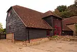 Barn to North West Corner of Home Farm Courtyard |
| Church of St Nicholas | Peper Harow Park, Peper Harow, Waverley | Church | 12th century | 9 March 1960 | SU9346544062 51°11′17″N 0°39′50″W |
1352737 | 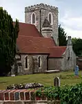 Church of St Nicholas |
| Dovecot and Granary to South West of Home Farm Courtyard | Peper Harow Park, Peper Harow, Waverley | Dovecote | 18th century | 2 January 1986 | SU9343044162 51°11′21″N 0°39′52″W |
1044441 | 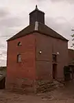 Dovecot and Granary to South West of Home Farm Courtyard |
| Home Farm Cottages with Stables to Left and Buildings to East | Peper Harow, Waverley | House | 18th century | 2 January 1986 | SU9348144198 51°11′22″N 0°39′49″W |
1352736 | 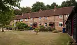 Home Farm Cottages with Stables to Left and Buildings to East |
| Somerset Bridge | Peper Harow, Waverley | Bridge | 13th century | 9 March 1960 | SU9217743926 51°11′14″N 0°40′57″W |
1188935 | 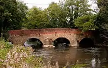 Somerset Bridge |
| Tilford House | Tilford, Waverley | House | c. 1700 | 9 March 1960 | SU8699843596 51°11′06″N 0°45′24″W |
1352763 | .jpg.webp) Tilford House |
| Barn at Oxenford Grange | Witley, Waverley | Barn | 1843 | 9 March 1960 | SU9323143217 51°10′50″N 0°40′03″W |
1334359 | 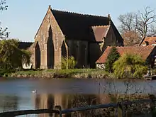 Barn at Oxenford Grange |
| Granary and Farm Buildings at Oxenford Farm | Witley, Waverley | Farm Building | 1843 | 28 October 1986 | SU9320543244 51°10′51″N 0°40′05″W |
1097014 | |
| Oxenford Gate Lodge | Witley, Waverley | Gate Lodge | 1843-4 | 9 March 1960 | SU9318343238 51°10′51″N 0°40′06″W |
1096948 | 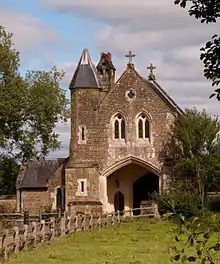 Oxenford Gate Lodge |
| Statue of Neptune with Attached Underwater Tunnel, Stairs, Circular and Rectangular Chambers and Artificial Island, Witley Park | Witley Park, Witley, Waverley | Steps | c. 1900 | 28 October 1986 | SU9217139560 51°08′52″N 0°41′01″W |
1096871 | 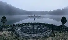 Statue of Neptune with Attached Underwater Tunnel, Stairs, Circular and Rectangular Chambers and Artificial Island, Witley Park |
| Barnett Hill [Conference Centre] |
Wonersh, Waverley | House | c. 1905 | 28 October 1986 | TQ0243145442 51°11′56″N 0°32′07″W)] |
1241148 | 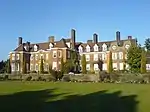 Barnett Hill [Conference Centre] |
| Church of St John the Baptist | Wonersh, Waverley | Church | Pre Conquest | 9 March 1960 | TQ0146445098 51°11′46″N 0°32′57″W |
1241510 | 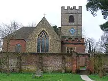 Church of St John the Baptist |
| The Dower House | Wonersh, Waverley | House | c. 1710 | 9 March 1960 | TQ0182745235 51°11′50″N 0°32′39″W |
1241146 | |
See also
- Grade I listed buildings in Surrey (Waverley)
Notes
- The date given is the date used by Historic England as significant for the initial building or that of an important part in the structure's description.
- Sometimes known as OSGB36, the grid reference is based on the British national grid reference system used by the Ordnance Survey.
- The "List Entry Number" is a unique number assigned to each listed building and scheduled monument by Historic England.
References
- Clifton-Taylor, Alec (1963). "Future of a Georgian Town". Country Life. 134: 792.
External links
| Wikimedia Commons has media related to Grade II* listed buildings in Surrey. |
This article is issued from Wikipedia. The text is licensed under Creative Commons - Attribution - Sharealike. Additional terms may apply for the media files.