Grade I listed buildings in County Durham
There are more than 9000 Grade I listed buildings in England. This page is a list of these buildings in the county of Durham, sub-divided by unitary authority.
County Durham shown in England
County Durham
| Name | Location | Type | Completed [note 1] | Date designated | Grid ref.[note 2] Geo-coordinates |
Entry number [note 3] | Image |
|---|---|---|---|---|---|---|---|
| Barnard Castle Bridge (that Part in Barnard Castle Civil Parish) and Attached Wall to South East | River Tees, Barnard Castle, County Durham | Wall | 14th century | 24 February 1950 | NZ0481216389 54°32′34″N 1°55′38″W |
1201056 | 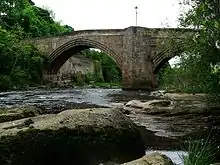 Barnard Castle Bridge (that Part in Barnard Castle Civil Parish) and Attached Wall to South East |
| Blagraves | Barnard Castle, County Durham | House | 16th/17th century | 24 February 1950 | NZ0501616219 54°32′28″N 1°55′26″W |
1201313 | 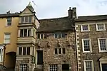 Blagraves |
| Bowes Museum with Steps and Railings Attached | Barnard Castle, County Durham | Museum | 1869–c. 1885 | 24 February 1950 | NZ0556416317 54°32′32″N 1°54′56″W |
1292074 | 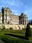 Bowes Museum with Steps and Railings Attached |
| Church of St Mary | Barnard Castle, County Durham | Parish Church | 12th-14th century | 24 February 1950 | NZ0507716271 54°32′30″N 1°55′23″W |
1218277 | 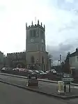 Church of St Mary |
| Market Cross | Barnard Castle, County Durham | Market Cross | 1747 | 24 February 1950 | NZ0503216330 54°32′32″N 1°55′25″W |
1201323 | 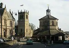 Market Cross |
| Terrace Walls and Steps, and Heraldic Beasts, to South of Bowes Museum | Barnard Castle, County Durham | Balustrade | c. 1885 | 28 November 1994 | NZ0556416270 54°32′30″N 1°54′56″W |
1218235 | 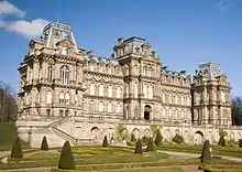 Terrace Walls and Steps, and Heraldic Beasts, to South of Bowes Museum |
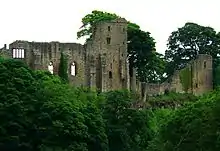
| The Castle | Barnard Castle, County Durham | Castle | c. 1095 | 24 February 1950 | NZ0487516466 54°32′36″N 1°55′34″W |
1218822 | |
| Auckland Castle | Bishop Auckland, County Durham | Castle | Medieval | 21 April 1952 | NZ2134130200 54°39′59″N 1°40′14″W |
1196444 | |
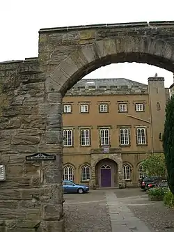
| Auckland Castle entrance gateway | Bishop Auckland, County Durham | Gatehouse | 1760 | 21 April 1952 | NZ2130030124 54°39′57″N 1°40′17″W |
1297645 | 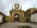 Auckland Castle entrance gateway |
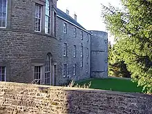
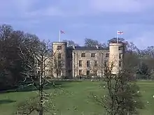
| Auckland Castle west mural tower and west walls | Bishop Auckland, County Durham | Bishops Palace | c. 1660 | 21 April 1952 | NZ2125430199 54°39′59″N 1°40′19″W |
1196445 |  Auckland Castle west mural tower and west walls |
| Castle Lodge | Bishop Auckland, County Durham | Lodge | 17th century | 21 April 1952 | NZ2131030111 54°39′56″N 1°40′16″W |
1297529 | 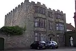 Castle Lodge |
| Chapel of St Peter at Auckland Castle | Bishop Auckland, County Durham | Chapel | c. 1190 - early 13th century | 21 April 1952 | NZ2138730249 54°40′01″N 1°40′12″W |
1196446 | 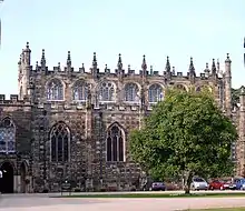 Chapel of St Peter at Auckland Castle |
| Deer Shelter in Auckland Castle Park | Bishop Auckland, County Durham | Bishops Palace | c. 1760 | 21 April 1952 | NZ2159530444 54°40′07″N 1°40′00″W |
1297608 | 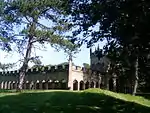 Deer Shelter in Auckland Castle Park |
| Newton Cap Bridge | Bishop Auckland, County Durham | Road Bridge | late 14th century | 21 April 1952 | NZ2051230258 54°40′01″N 1°41′01″W |
1292118 |  Newton Cap Bridge |
| Screen Wall and Garden Walls to South and East of Auckland Castle | Bishop Auckland, County Durham | Bishops Palace | c. 1795 | 21 April 1952 | NZ2140630168 54°39′58″N 1°40′11″W |
1196448 | 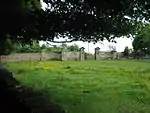 Screen Wall and Garden Walls to South and East of Auckland Castle |
| Biddick Hall | Lambton Park, Bournmoor, County Durham | Country House | Early 18th century | 1 February 1967 | NZ3145352792 54°52′08″N 1°30′41″W |
1120989 | |
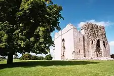
| Bowes Castle | Bowes, County Durham | Castle | 1171-87 | 17 June 1986 | NY9923413504 54°31′01″N 2°00′48″W |
1121039 | |
| Brancepeth Castle | Brancepeth Park, Brancepeth, County Durham | Castle | 1216 | 10 May 1967 | NZ2232037710 54°44′02″N 1°39′18″W |
1159012 | |
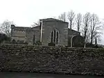
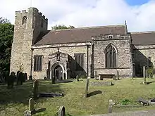
| Church of St Brandon | Brancepeth Park, Brancepeth, County Durham | Parish Church | Late 12th century | 10 May 1967 | NZ2247937696 54°44′01″N 1°39′09″W |
1158956 |  Church of St Brandon |
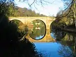
| Sunderland Bridge | Sunderland Bridge, Croxdale and Hett, County Durham | Road Bridge | 14th century | 10 May 1967 | NZ2652037766 54°44′03″N 1°35′23″W |
1311172 | |
| Sunderland Bridge | Brandon and Byshottles, County Durham | Road Bridge | 14th century | 3 May 1967 | NZ2651437769 54°44′03″N 1°35′23″W |
1120699 | _20070630.JPG.webp) Sunderland Bridge |
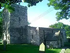
| Church 50 Metres North East of Croxdale Hall | Croxdale Hall, Croxdale and Hett, County Durham | Church | Late 11th -early 12th century | 10 May 1967 | NZ2740437912 54°44′08″N 1°34′33″W |
1120740 | 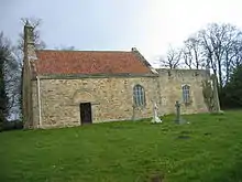 Church 50 Metres North East of Croxdale Hall |
| Croxdale Hall | Croxdale, Croxdale and Hett, County Durham | Country House | 17th century | 10 May 1967 | NZ2734137856 54°44′06″N 1°34′37″W |
1159140 | |
| East Deanery | South Church, Dene Valley, County Durham | Courtyard | Shortly After 1293 | 21 April 1952 | NZ2157928301 54°38′58″N 1°40′02″W |
1196576 | |
| Church of St Mary | Easington, County Durham | Parish Church | Early 13th century | 20 February 1967 | NZ4142843445 54°47′03″N 1°21′26″W |
1231813 | 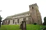 Church of St Mary |
| Seaton Holme | Easington, County Durham | House | c. 1600 | 6 August 1952 | NZ4136443520 54°47′06″N 1°21′30″W |
1231692 | 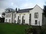 Seaton Holme |
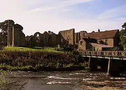
| Ruins of Egglestone Abbey | Egglestone Abbey, County Durham | Abbey | 1195–1198 | 28 October 1987 | NZ0623815121 54°31′53″N 1°54′18″W |
1322741 | 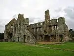 Ruins of Egglestone Abbey |
| Chapel of St Michael at College of St Cuthbert Mortuary Chapel | Ushaw Moor, County Durham | Chapel | 1858-9 | 24 June 1987 | NZ2183643711 54°47′16″N 1°39′43″W |
1299435 | |
| Finchale Priory | Finchale Priory, Framwellgate Moor, County Durham | Priory | 15th century | 10 May 1967 | NZ2964347130 54°49′05″N 1°32′25″W |
1159246 | |
| Church of St Mary | Gainford, County Durham | Parish Church | Early 13th century | 14 September 1966 | NZ1697116683 54°32′42″N 1°44′21″W |
1121114 | 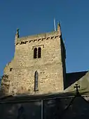 Church of St Mary |
| Gainford Hall | Gainford, County Durham | Manor House | c. 1603 | 7 January 1952 | NZ1682416854 54°32′48″N 1°44′29″W |
1323010 | |
| Church of St Andrew | Great Aycliffe, County Durham | Cross | Late 10th century | 12 November 1980 | NZ2830622163 54°35′38″N 1°33′48″W |
1322806 |  Church of St Andrew |
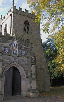
| Church of St James | Hamsterley, Bishop Auckland, County Durham | Church | 1803 | 14 September 1966 | NZ1272930895 54°40′23″N 1°48′15″W |
1322777 | 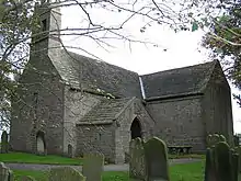 Church of St James |
| Church of St Helen | Kelloe, County Durham | Cross | 12th century | 10 May 1967 | NZ3450936542 54°43′22″N 1°27′57″W |
1120748 | 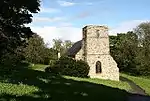 Church of St Helen |
| Church of All Saints | Lanchester, County Durham | Collegiate Church | 12th century | 17 January 1967 | NZ1676247392 54°49′16″N 1°44′26″W |
1185983 | 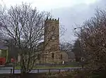 Church of All Saints |
| Lumley Castle | Chester-le-Street, County Durham | Castle | 1382 | 4 June 1952 | NZ2876851054 54°51′12″N 1°33′12″W |
1120960 | |
| Remains of Manor House at Priory Farm | Muggleswick, County Durham | Hunting Lodge | 13th century | 6 February 1952 | NZ0443550021 54°50′42″N 1°55′57″W |
1260912 | 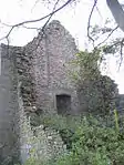 Remains of Manor House at Priory Farm |
| Church of St Laurence | Hallgarth, Pittington, County Durham | Church | 15th century | 10 May 1967 | NZ3288143579 54°47′10″N 1°29′25″W |
1310892 | .jpg.webp) Church of St Laurence |
| Elemore Hall School and Doorway and Archway Attached | Pittington, County Durham | House | 19th century | 28 February 1952 | NZ3510044168 54°47′28″N 1°27′20″W |
1120730 | |
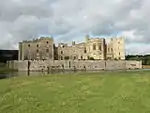
| North Gatehouse and Walls Attached Enclosing Castle; Gate House Formerly Listed As 'porter's Lodge' | Raby Castle, Staindrop, County Durham | Curtain Wall | 14th century | 14 September 1966 | NZ1289021841 54°35′30″N 1°48′07″W |
1338626 | 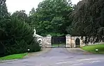 North Gatehouse and Walls Attached Enclosing Castle; Gate House Formerly Listed As 'porter's Lodge' |
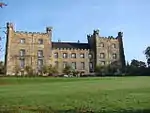
| Raby Castle | Raby Castle, Staindrop, County Durham | Castle | Early-Mid 14th century | 7 January 1952 | NZ1292321766 54°35′27″N 1°48′06″W |
1338625 | |
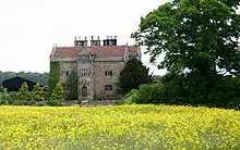
| Mortham Tower | Rokeby Park, County Durham | House | 20th century | 19 January 1952 | NZ0861014209 54°31′23″N 1°52′07″W |
1160832 |  Mortham Tower |
| Rokeby Park and Attached Stables | Rokeby Park, County Durham | Country House | 1725–31 | 19 January 1952 | NZ0828214181 54°31′22″N 1°52′25″W |
1121680 | 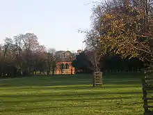 Rokeby Park and Attached Stables |
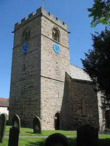
| Church of St Romald | Romaldkirk, County Durham | Parish Church | Late 12th – early 13th century | 12 January 1967 | NY9951922126 54°35′40″N 2°00′32″W |
1121857 |  Church of St Romald |
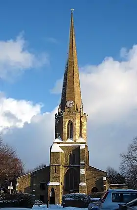
| Church of St Mary | Seaham, County Durham | Church | 1773 | 21 June 1950 | NZ4224350500 54°50′51″N 1°20′37″W |
1232116 | 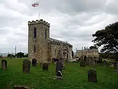 Church of St Mary |
| Church of St Edmund | Sedgefield, County Durham | Church | c. 1490 | 9 January 1968 | NZ3568028823 54°39′12″N 1°26′55″W |
1121482 | |
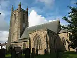
| Church of St Mary | Staindrop, County Durham | Collegiate Church | Early 15th century to c. 1544 | 14 September 1966 | NZ1310220638 54°34′51″N 1°47′56″W |
1338594 | 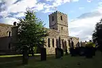 Church of St Mary |
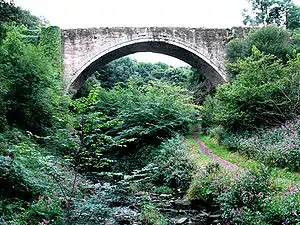
| Causey Arch | Stanley, County Durham | Bridge | 1727 | 19 July 1950 | NZ2012655896 54°53′51″N 1°41′16″W |
1240816 | |
| Culvert, Arch and Retaining Walls, in West Face of Embankment over Causey Burn | Stanley, County Durham | Wagonway | 1717 | 21 January 1987 | NZ2038356055 54°53′56″N 1°41′01″W |
1260837 | |
| Walls, Piers, Steps, Gates and Railings in Front of Tanfield Hall | Tanfield, Stanley, County Durham | Gate | Early 18th century | 19 July 1950 | NZ1887455432 54°53′36″N 1°42′26″W |
1260787 | .jpg.webp) Walls, Piers, Steps, Gates and Railings in Front of Tanfield Hall |
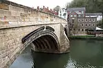
| Barnard Castle Bridge, over the River Tees | Startforth, County Durham | Road Bridge | 1569 | 12 January 1967 | NZ0479616387 54°32′34″N 1°55′39″W |
1121647 | 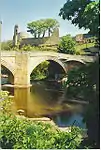 Barnard Castle Bridge, over the River Tees |
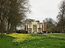
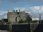
| The Old Manor House Hotel | West Auckland, County Durham | Manor House | 15th century | 21 April 1952 | NZ1791826357 54°37′55″N 1°43′26″W |
1209970 | 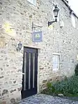 The Old Manor House Hotel |
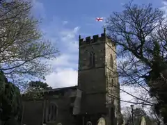
| Church of St Andrew | Winston, County Durham | Parish Church | Mid 13th century | 14 September 1966 | NZ1435016873 54°32′49″N 1°46′47″W |
1160127 | 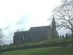 Church of St Andrew |
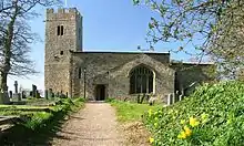
| Church of St Mary | Wycliffe, County Durham | Parish Church | Mid 13th century | 12 January 1967 | NZ1168414324 54°31′27″N 1°49′16″W |
1322763 | 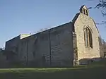 Church of St Mary |
| Durham Castle, Bastion Behind No. 50 and Wall Attached | Durham, County Durham | Bastion | Late Medieval | 10 March 1988 | NZ2743442368 54°46′32″N 1°34′30″W |
1322897 | |
| Durham Castle Gatehouse, Entrance Gateway, Side Walls, Linking Walls and Front Wall | Durham, County Durham | Gatehouse | c. 1790 | 6 May 1952 | NZ2735042336 54°46′31″N 1°34′35″W |
1322867 | 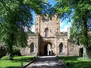 Durham Castle Gatehouse, Entrance Gateway, Side Walls, Linking Walls and Front Wall |
| Durham Castle Terrace Wall Castle Wall Behind Nos 7-18 Consecutive | Durham, County Durham | Terrace | Medieval | 6 May 1952 | NZ2736242401 54°46′33″N 1°34′34″W |
1323246 | |
| Durham Castle Wall Around Motte on West, North and East Sides | Durham, County Durham | Curtain Wall | Medieval | 6 May 1952 | NZ2731242413 54°46′33″N 1°34′37″W |
1120631 | |
| Durham Castle Wall Behind Hatfield College | Durham, County Durham | Wall | 12th century | 6 May 1952 | NZ2751242273 54°46′29″N 1°34′26″W |
1121422 | |
| Durham Castle Wall Behind No.3 | Durham, County Durham | Wall | 12th century | 6 May 1952 | NZ2749442340 54°46′31″N 1°34′27″W |
1322845 | |
| Durham Castle Wall Behind Nos. 16-22 and No.22a (st. Chad's) | Durham, County Durham | Curtain Wall | 12th century | 6 May 1952 | NZ2749042085 54°46′23″N 1°34′27″W |
1121431 | |
| Durham Castle Wall Behind Nos. 26-28 | Durham, County Durham | Curtain Wall | 12th century | 6 May 1952 | NZ2745442011 54°46′20″N 1°34′29″W |
1310622 | |
| Durham Castle Walls Terrace Wall North of Bow Lane | Durham, County Durham | Curtain Wall | 12th century | 6 May 1952 | NZ2753642150 54°46′25″N 1°34′25″W |
1120714 | |
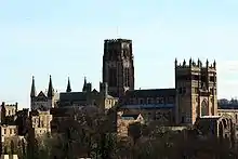
| Cathedral Church of Christ and St.mary the Virgin | Durham, County Durham | Cathedral | 1242-c. 1280 | 6 May 1952 | NZ2734642123 54°46′24″N 1°34′35″W |
1161023 | |
| Durham Cathedral Cloister East Range | Durham, County Durham | Cathedral | 11th century | 6 May 1952 | NZ2735342107 54°46′23″N 1°34′35″W |
1121388 | .jpg.webp) Durham Cathedral Cloister East Range |
| Durham Cathedral Cloister South Range | Durham, County Durham | Cathedral | 11th century | 6 May 1952 | NZ2731942088 54°46′23″N 1°34′37″W |
1310239 | Durham Cathedral Cloister South Range |
| Durham Cathedral Cloister West Range | Durham, County Durham | Wall | 12th century | 6 May 1952 | NZ2729542106 54°46′23″N 1°34′38″W |
1121389 | .jpg.webp) Durham Cathedral Cloister West Range |
| Chapel of St Mary Magdalene | Gilesgate, Durham, County Durham | Chapel | 13th century | 6 May 1952 | NZ2826342903 54°46′49″N 1°33′44″W |
1159279 |  Chapel of St Mary Magdalene |
| Chorister School | Durham, County Durham | Clergy House | Medieval | 6 May 1952 | NZ2726541963 54°46′19″N 1°34′40″W |
1159555 | |
| Church of St Andrew | South Church, County Durham | Cross | Late 8th/early 9th century | 21 April 1952 | NZ2175228470 54°39′03″N 1°39′52″W |
1196458 | 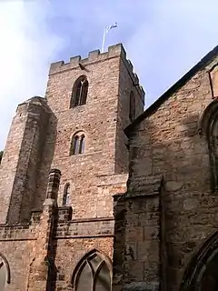 Church of St Andrew |
| Church of St Helen | St Helen Auckland, County Durham | Schoolroom | 15th century | 21 April 1952 | NZ1883526773 54°38′09″N 1°42′35″W |
1196602 | |
| Church of St Mary and St Cuthbert | Chester-le-Street, County Durham | Parish Church | Mid 13th century | 29 July 1950 | NZ2760351316 54°51′21″N 1°34′18″W |
1120955 | |
| Church of St Mary Magdalene | Medomsley, County Durham | Parish Church | 13th century | 6 June 1951 | NZ1189154374 54°53′02″N 1°48′58″W |
1240478 | |
| Church of St Giles | Gilesgate, Durham, County Durham | Church | Early 13th century | 6 May 1952 | NZ2838842653 54°46′41″N 1°33′37″W |
1159991 | |
| Church of St Margaret of Antioch | Crossgate, Durham, County Durham | Parish Church | 12th century | 6 May 1952 | NZ2712142405 54°46′33″N 1°34′48″W |
1159741 | |
| Crook Hall | Framwelgate, Durham, County Durham | Hall House | 14th century | 6 May 1952 | NZ2744943152 54°46′57″N 1°34′29″W |
1159909 | |
| Derwent Cote Steel Furnace (the Cone) | Hamsterley Colliery, Hameterly, County Durham | Cementation Furnace | First half of 18th century | 6 June 1951 | NZ1304656508 54°54′11″N 1°47′53″W |
1240411 | 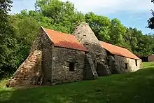 Derwent Cote Steel Furnace (the Cone) |
| Elvet Bridge | Durham, County Durham | Bridge | Late 12th century | 6 May 1952 | NZ2753642424 54°46′34″N 1°34′24″W |
1121355 | |
| Former Exchequer Building, Now University Library | Durham, County Durham | Court House | 1438–1457 | 10 March 1988 | NZ2734442299 54°46′30″N 1°34′35″W |
1160838 | 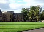 Former Exchequer Building, Now University Library |
| Framwellgate Bridge | Durham, County Durham | Bridge | Early 12th century | 6 May 1952 | NZ2723742431 54°46′34″N 1°34′41″W |
1322872 | |
| Great Gateway to Kepier Hospital (that Part Within the City of Durham) | Durham, County Durham | Hospital | 14th century | 19 February 1970 | NZ2821243266 54°47′01″N 1°33′46″W |
1121391 | 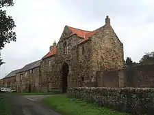 Great Gateway to Kepier Hospital (that Part Within the City of Durham) |
| Great Gateway to Kepier Hospital (that Part Within the Civil Parish of Belmont) | Durham, County Durham | Hospital | 14th century | 14 January 1988 | NZ2821243266 54°47′01″N 1°33′46″W |
1120725 | Great Gateway to Kepier Hospital (that Part Within the Civil Parish of Belmont) |
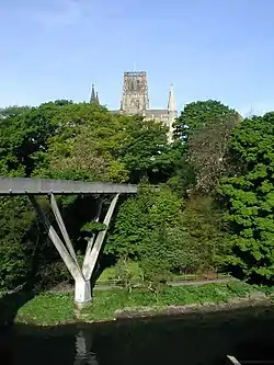
| Kingsgate Bridge | Durham, County Durham | Footbridge | 1963 | 29 May 1998 | NZ2759342106 54°46′23″N 1°34′21″W |
1119766 | |
| Lavatorium in Centre of Cloister Garth | Durham Cathedral, Durham, County Durham | Wash House | Medieval | 6 May 1952 | NZ2732242113 54°46′24″N 1°34′37″W |
1161129 | 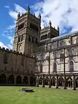 Lavatorium in Centre of Cloister Garth |
| Loggia of Heath Family Mansion East of Great Gateway at Kepier Hospital | Durham, County Durham | Loggia | Late 16th century | 10 March 1988 | NZ2823343248 54°47′00″N 1°33′45″W |
1310224 | |
| Prebends Bridge | Durham, County Durham | Bridge | 1772-8 | 6 May 1952 | NZ2714541856 54°46′15″N 1°34′47″W |
1121354 | |
| Prior's Kitchen (Dean and Chapter Library) | Durham Cathedral, Durham, County Durham | Kitchen | 1366-74 | 6 May 1952 | NZ2730142061 54°46′22″N 1°34′38″W |
1323260 | 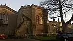 Prior's Kitchen (Dean and Chapter Library) |
| Priory Prison and Former Stables North of Number 15 | Durham, County Durham | Prison and stables | Medieval | 6 May 1952 | NZ2726942103 54°46′23″N 1°34′39″W |
1323259 | 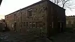 Priory Prison and Former Stables North of Number 15 |
| St Helen Hall | St Helen Auckland, County Durham | House | c. 1735 | 21 April 1952 | NZ1894626772 54°38′09″N 1°42′29″W |
1297566 | 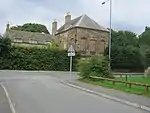 St Helen Hall |
| St Mary Le Bow Heritage Centre | Durham, County Durham | Church | 1702 | 6 May 1952 | NZ2747242162 54°46′25″N 1°34′28″W |
1121424 | |
| Terrace Wall South of Bow Lane and East of Kingsgate | Durham, County Durham | Curtain Wall | 12th century | 6 May 1952 | NZ2753342135 54°46′24″N 1°34′25″W |
1159233 | |
| Durham Castle, north range | Durham, County Durham | Castle | c. 1072 | 6 May 1952 | NZ2734542387 54°46′32″N 1°34′35″W |
1160921 | 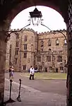 Durham Castle, north range |
| Durham Castle west range | Durham, County Durham | Castle | Late 15th century | 6 May 1952 | NZ2732042359 54°46′31″N 1°34′37″W |
1121383 | 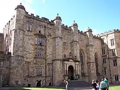 Durham Castle west range |
| The Deanery | Durham, County Durham | Deanery | Norman | 6 May 1952 | NZ2735842077 54°46′22″N 1°34′35″W |
1120655 | 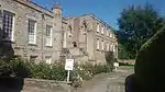 The Deanery |
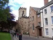
| The Gatehouse | Durham, County Durham | Muniment House | c. 1500 | 6 May 1952 | NZ2740742017 54°46′20″N 1°34′32″W |
1159471 |  The Gatehouse |
| The Keep (University College) | Durham, County Durham | Keep | 1345-81 | 6 May 1952 | NZ2739542357 54°46′31″N 1°34′32″W |
1322868 | 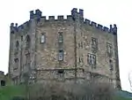 The Keep (University College) |
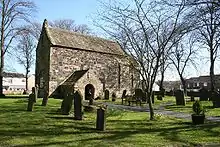
| The Saxon Church | Escomb, County Durham | Cross | 7th Century | 21 April 1952 | NZ1892830139 54°39′58″N 1°42′29″W |
1292122 | |
| Wall Behind Nos. 12 and 12a | Durham, County Durham | Curtain Wall | 12th century | 10 March 1988 | NZ2727741814 54°46′14″N 1°34′39″W |
1161398 | |
| Wall Behind St.john's College from Nos. 1 to 11 Consecutive, and Garden House Attached Behind No.11 | Durham, County Durham | Privy House | Early 18th century | 10 March 1988 | NZ2735741854 54°46′15″N 1°34′35″W |
1322901 | |
| Durham, Wall to West of No.13 | County Durham | Garden Wall | 18th century | 10 March 1988 | NZ2724841871 54°46′16″N 1°34′41″W |
1121334 | |
| Walls Attached to Numbers 12 to 15 | Durham, County Durham | Curtain Wall | 12th century | 10 March 1988 | NZ2726142110 54°46′23″N 1°34′40″W |
1120695 | |
| unnamed house | 18 Elvet Bridge, Durham, County Durham | House | Late 19th century | 30 April 1971 | NZ2749642457 54°46′35″N 1°34′27″W |
1323228 | |
| houses | 12-15 The College, Durham, County Durham | House | Medieval | 6 May 1952 | NZ2726642040 54°46′21″N 1°34′40″W |
1120694 | 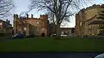 houses |
| unnamed house | 8 The College, Durham, County Durham | House | Medieval | 6 May 1952 | NZ2730041977 54°46′19″N 1°34′38″W |
1120691 | 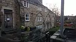 unnamed house |


.jpg.webp)


Darlington
| Name | Location | Type | Completed [note 1] | Date designated | Grid ref.[note 2] Geo-coordinates |
Entry number [note 3] | Image |
|---|---|---|---|---|---|---|---|
| Church of St Michael | Heighington, Darlington | Church | 18th century | 20 March 1967 | NZ2490322365 54°35′45″N 1°36′58″W |
1322953 | |
| Thornton Hall | High Coniscliffe, Darlington | Farmhouse | 1952 | 6 June 1952 | NZ2381816991 54°32′51″N 1°38′00″W |
1121221 | |
| Church of All Saints | Sockburn, Darlington | Cross | Pre Conquest | 20 March 1967 | NZ3498207113 54°27′30″N 1°27′43″W |
1185947 | 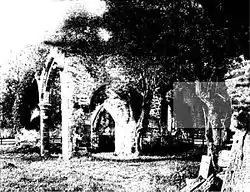 Church of All Saints |
| Walworth Castle | Walworth, Darlington | Country House | c. 1600 | 6 June 1952 | NZ2312418828 54°33′51″N 1°38′38″W |
1121175 | |
| Butler House and the Rectory | Haughton-le-Skerne, Darlington | House | Early-mid 15th century | 28 April 1952 | NZ3083815930 54°32′16″N 1°31′30″W |
1121301 | |
| Church of St Andrew | Haughton Le Skerne, Darlington | Church | c. 1100 | 28 April 1952 | NZ3082715886 54°32′14″N 1°31′30″W |
1160229 | |
| Church of St Cuthbert | Darlington | Church | Early 13th century | 28 April 1952 | NZ2910614442 54°31′28″N 1°33′07″W |
1121280 |

Hartlepool
| Name | Location | Type | Completed [note 1] | Date designated | Grid ref.[note 2] Geo-coordinates |
Entry number [note 3] | Image |
|---|---|---|---|---|---|---|---|
| Church of St Mary Magdalene | Hart, Hartlepool | Church | Anglo-Saxon | 16 November 1967 | NZ4704835107 54°42′32″N 1°16′17″W |
1249898 | |
| Church of St Hilda | Headland, Hartlepool | Church | Early 12th century | 31 March 1949 | NZ5284233679 54°41′43″N 1°10′54″W |
1263355 | |
| Town Wall and Sandwell Gate | Headland, Hartlepool | Gate | Early 14th century | 31 March 1949 | NZ5246133698 54°41′44″N 1°11′15″W |
1250535 |  Town Wall and Sandwell Gate |
Stockton-on-Tees
| Name | Location | Type | Completed [note 1] | Date designated | Grid ref.[note 2] Geo-coordinates |
Entry number [note 3] | Image |
|---|---|---|---|---|---|---|---|
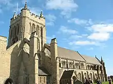
| Church of St Cuthbert | Billingham, Stockton-on-Tees | Church | 9th century | 25 January 1951 | NZ4576122339 54°35′39″N 1°17′36″W |
1139241 | 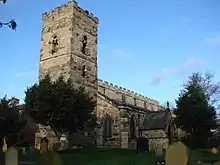 Church of St Cuthbert |
| Church of St John the Baptist | Egglescliffe, Stockton-on-Tees | Church | Norman | 16 November 1967 | NZ4206513166 54°30′43″N 1°21′06″W |
1104901 | |
| Ruins of a Church of St Thomas a Becket | Grindon, Stockton-on-Tees | Church | Late 12th century | 16 November 1967 | NZ3978125435 54°37′21″N 1°23′08″W |
1329821 | |
| Church of St Peter | Hilton, Stockton-on-Tees[note 4] | Church | Norman | 23 June 1966 | NZ4656811314 54°29′42″N 1°16′57″W |
1139229 | |
| Church of St Cuthbert | Redmarshall, Stockton-on-Tees | Church | Norman | 16 November 1967 | NZ3862221189 54°35′04″N 1°24′14″W |
1140001 | |
| Church of St Thomas | Stockton-on-Tees | Church | Medieval | 19 January 1951 | NZ4457219251 54°34′00″N 1°18′44″W |
1139977 | 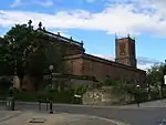 Church of St Thomas |
| Parish Church of St Mary the Virgin | Stockton-on-Tees | Parish Church | Early 11th century | 19 January 1951 | NZ4427622126 54°35′33″N 1°18′59″W |
1140012 |  Parish Church of St Mary the Virgin |
.jpg.webp)
Notes
- The date given is the date used by Historic England as significant for the initial building or that of an important part in the structure's description.
- Sometimes known as OSGB36, the grid reference is based on the British national grid reference system used by the Ordnance Survey.
- The "List Entry Number" is a unique number assigned to each listed building and scheduled monument by Historic England.
- Technically in North Yorkshire not County Durham, but it is listed here with other listed buildings in Stockton-on-Tees
References
- National Heritage List for England
- Keys To The Past Durham/Northumbria councils site
External links
![]() Media related to Grade I listed buildings in County Durham at Wikimedia Commons
Media related to Grade I listed buildings in County Durham at Wikimedia Commons
This article is issued from Wikipedia. The text is licensed under Creative Commons - Attribution - Sharealike. Additional terms may apply for the media files.