Grade I listed buildings in South Gloucestershire
There are over 9,000 Grade I listed buildings in England. This page is a list of these buildings in the district of South Gloucestershire within Gloucestershire.

Gloucestershire shown in England
South Gloucestershire
| Name | Location | Type | Completed [note 1] | Date designated | Grid ref.[note 2] Geo-coordinates |
Entry number [note 3] | Image |
|---|---|---|---|---|---|---|---|
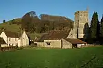
| Church of St Mary | Almondsbury, South Gloucestershire | Parish Church | Late 12th century | 30 March 1960 | ST6034884085 51°33′15″N 2°34′24″W |
1128858 | 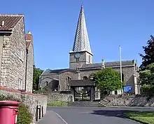 Church of St Mary |
| Severn Bridge and Aust Viaduct First Severn Crossing | Aust | Suspension Bridge | 1961-1966 | 29 May 1998 | ST5654089830 51°36′20″N 2°37′44″W |
1119760 |  Severn Bridge and Aust Viaduct First Severn Crossing |
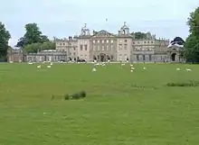
| Badminton House | Badminton Park, Badminton | Country House | Late 1660s to 1690s | 17 September 1952 | ST8066682913 51°32′41″N 2°16′49″W |
1320832 | |
| Church of St Michael and All Angels | Badminton Park, Badminton | Anglican Church | 1785 | 3 March 1961 | ST8068682866 51°32′40″N 2°16′48″W |
1155177 | |
| Parish Church of St Mary | Bitton | Parish Church | Anglo Saxon origins | 11 May 1953 | ST6819469334 51°25′20″N 2°27′32″W |
1116770 | 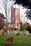 Parish Church of St Mary |
| Church of St James | Charfield | Church | Redundant | 30 March 1960 | ST7190091098 51°37′05″N 2°24′26″W |
1321189 | |
| Church of Holy Trinity | Cold Ashton | Parish Church | 14th century | 15 August 1985 | ST7510372737 51°27′11″N 2°21′35″W |
1220484 | 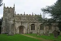 Church of Holy Trinity |
| Garden Walls and Gateways about 15m South of the Manor House | Cold Ashton | Gate | Early 17th century | 17 September 1952 | ST7501372614 51°27′07″N 2°21′40″W |
1290769 | .jpg.webp) Garden Walls and Gateways about 15m South of the Manor House |
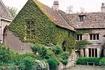
| The Manor House | Cold Ashton | House | c 1570-75 | 17 September 1952 | ST7500472638 51°27′08″N 2°21′40″W |
1220865 | The Manor House |
| Parish Church of St Andrew | Cromhall | Anglican Church | 1852 | 30 March 1960 | ST6922290501 51°36′45″N 2°26′45″W |
1114974 | 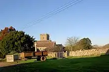 Parish Church of St Andrew |
| Church of St Mary | Dodington Park, Dodington | Church (private) | Medieval | 15 August 1985 | ST7520979880 51°31′02″N 2°21′31″W |
1211173 |  |
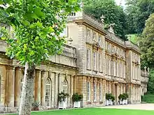
| Dodington House | Dodington Park, Dodington | House | 1796-1816 | 17 September 1952 | ST7525079860 51°31′02″N 2°21′29″W |
1211169 | |
| Dower House | Dodington Park, Dodington | Dower House | Between 1796 and 1816 | 17 September 1952 | ST7521979938 51°31′04″N 2°21′31″W |
1290138 | |
| Orangery attached to North West of Dodington House | Dodington Park, Dodington | Orangery | 1799 | 15 August 1985 | ST7522079873 51°31′02″N 2°21′31″W |
1211172 | |
| Stables | Dodington Park, Dodington | Courtyard | 1796-1816 | 17 September 1952 | ST7517979918 51°31′03″N 2°21′33″W |
1290139 | |
| Church of St Peter | Dyrham Park, Dyrham and Hinton | Parish Church | Mid 13th century | 15 August 1985 | ST7414475804 51°28′50″N 2°22′25″W |
1289711 | 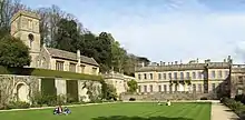 Church of St Peter |
| Dyrham House | Dyrham Park, Dyrham and Hinton | Country House | Tudor | 17 September 1952 | ST7418075766 51°28′49″N 2°22′24″W |
1212039 | |
| Orangery attached to South East of Dyrham House | Dyrham Park, Dyrham and Hinton | Glasshouse | 1701 | 15 August 1985 | ST7418375734 51°28′48″N 2°22′23″W |
1212042 | 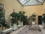 Orangery attached to South East of Dyrham House |
| Stable Block attached to South of Dyrham House | Dyrham Park, Dyrham and Hinton | Stables | 1698 | 15 August 1985 | ST7415275729 51°28′48″N 2°22′25″W |
1289719 | 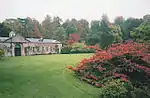 Stable Block attached to South of Dyrham House |
| Church of St Michael and All Angels | Little Badminton, Hawkesbury | Church | Early 13th century | 3 March 1961 | ST8017084252 51°33′24″N 2°17′15″W |
1303100 | 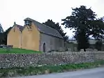 Church of St Michael and All Angels |
| Parish Church of St Mary the Virgin | Hawkesbury | Church | 13th century | 3 March 1961 | ST7681986925 51°34′51″N 2°20′09″W |
1320866 | |
| Swangrove House, Garden Walls, 4 Corner Pavilions and Gate Piers | Swangrove, Hawkesbury | House | 1703 | 17 September 1952 | ST7970585752 51°34′13″N 2°17′39″W |
1129379 | |
| Ambulatory 20m south-west of Horton Court | Horton | Loggia | c1527-1529 | 17 September 1952 | ST7661584989 51°33′48″N 2°20′20″W |
1321166 | .jpg.webp) Ambulatory 20m south-west of Horton Court |
| Horton Court | Horton | Clergy House | c. 1140 | 17 September 1952 | ST7662285029 51°33′49″N 2°20′19″W |
1114992 | |
| Parish Church of St James the Elder | Horton | Anglican Church | 16th century | 3 March 1961 | ST7660085035 51°33′49″N 2°20′20″W |
1114993 | 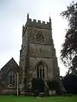 Parish Church of St James the Elder |
| Acton Court and Gateway and Flank Walls 40m East | Iron Acton | Farmhouse | 1680 | 9 February 2011 | ST6771084203 51°33′21″N 2°28′02″W |
1320155 | .jpg.webp) Acton Court and Gateway and Flank Walls 40m East |
| Church of St James the Less | Iron Acton | Anglican Church | 1879 | 27 November 1984 | ST6806583452 51°32′57″N 2°27′43″W |
1320130 | 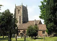 Church of St James the Less |
| Little Sodbury Manor | Little Sodbury | Manor House | Early 15th century | 17 September 1952 | ST7598082897 51°32′40″N 2°20′52″W |
1115005 | |
| Parish Church of St Mary | Marshfield | Parish church | 12th century | 3 March 1961 | ST7821473677 51°27′42″N 2°18′54″W |
1129438 | 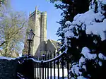 Parish Church of St Mary |
| Anglican Church of St Thomas à Becket / Church of St Thomas of Canterbury | Pucklechurch | Parish Church | Norman origin | 15 August 1985 | ST6992576533 51°29′13″N 2°26′04″W |
1212871 | 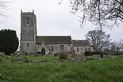 Anglican Church of St Thomas à Becket / Church of St Thomas of Canterbury |
| Parish Church of St Anne | Siston | Church | Mid 12th century | 11 May 1953 | ST6885475232 51°28′31″N 2°26′59″W |
1278090 | 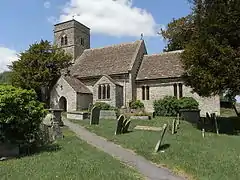 Parish Church of St Anne |
| Siston Court | Siston | House | Mid C20 | 11 May 1953 | ST6866175361 51°28′35″N 2°27′09″W |
1231511 | 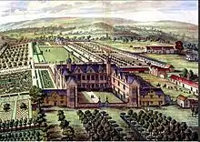 Siston Court |
| Parish Church of St John the Baptist | Chipping Sodbury | Parish Church | Early English | 29 July 1983 | ST7274882301 51°32′20″N 2°23′40″W |
1129307 | 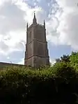 Parish Church of St John the Baptist |
| Church of St Mary the Virgin | Thornbury | Church | 1764 | 30 March 1960 | ST6340090620 51°36′48″N 2°31′48″W |
1128789 | 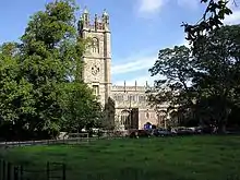 Church of St Mary the Virgin |
| Outer Court of Thornbury Castle and Wall of Kitchen Court | Thornbury | Castle | 1511-1521 | 21 September 1952 | ST6331490720 51°36′51″N 2°31′52″W |
1321132 | 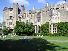 Outer Court of Thornbury Castle and Wall of Kitchen Court |
| Thornbury Castle, Inner Court | Thornbury | Castle | 1510-1521 | 21 September 1952 | ST6336590701 51°36′50″N 2°31′50″W |
1128788 | 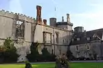 Thornbury Castle, Inner Court |
| Walls enclosing Privy Garden immediately to South of the Inner Court of Thornbury Castle | Thornbury | Wall | 1511-21 | 21 September 1952 | ST6343390678 51°36′49″N 2°31′46″W |
1312668 | 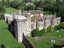 Walls enclosing Privy Garden immediately to South of the Inner Court of Thornbury Castle |
| Bath Lodge | Dodington Ash, Tormarton | Lodge | 1796-1816 | 17 September 1952 | ST7582378492 51°30′17″N 2°20′59″W |
1214012 | 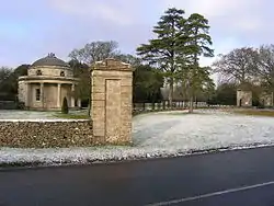 Bath Lodge |
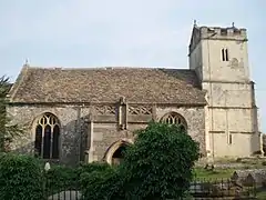
| Church of St Mary Magdelene | Tormarton | Parish Church | Norman | 15 August 1985 | ST7695178847 51°30′29″N 2°20′01″W |
1213492 | 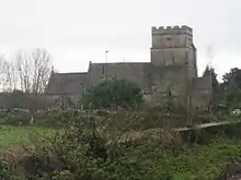 Church of St Mary Magdelene |
| Church of St James the Great | Westerleigh | Parish Church | 13th century | 15 August 1985 | ST6995279653 51°30′54″N 2°26′04″W |
1215174 | 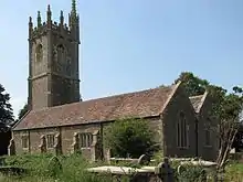 Church of St James the Great |
| Church of St James the Great | Abson, Wick and Abson | Parish Church | 12th century | 15 August 1985 | ST7053174845 51°28′18″N 2°25′32″W |
1216114 | 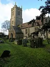 Church of St James the Great |
| Wick Court | Wick and Abson | House | Later | 17 September 1952 | ST7005672665 51°27′08″N 2°25′56″W |
1216153 | 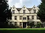 Wick Court |
| Church of St Michael | Winterbourne | Anglican Church | Mid-late 19th century | 3 March 1961 | ST6413781006 51°31′37″N 2°31′06″W |
1321086 | 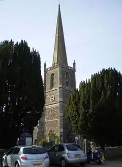 Church of St Michael |
| Parish Church of St Mary the Virgin | Yate | Anglican Church | 1859 | 3 March 1961 | ST7137082815 51°32′37″N 2°24′51″W |
1128753 | _St_Mary's_Church_-_geograph.org.uk_-_68137.jpg.webp) Parish Church of St Mary the Virgin |
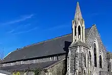
| Whitfield's Tabernacle | Park Road, Bristol | Chapel | 1741 | 6 June 1951 | ST6493173903 51°27′47″N 2°30′22″W |
1116201 |
.JPG.webp)
Notes
- The date given is the date used by Historic England as significant for the initial building or that of an important part in the structure's description.
- Sometimes known as OSGB36, the grid reference is based on the British national grid reference system used by the Ordnance Survey.
- The "List Entry Number" is a unique number assigned to each listed building and scheduled monument by Historic England.
References
External links
![]() Media related to Grade I listed buildings in Gloucestershire at Wikimedia Commons
Media related to Grade I listed buildings in Gloucestershire at Wikimedia Commons
This article is issued from Wikipedia. The text is licensed under Creative Commons - Attribution - Sharealike. Additional terms may apply for the media files.