Grade I listed buildings in Tyne and Wear
There are 75 Grade I listed buildings in Tyne and Wear, England.
In England and Wales the authority for listing is granted by the Planning (Listed Buildings and Conservation Areas) Act 1990 and is administered by English Heritage, an agency of the Department for Culture, Media and Sport. In Tyne and Wear, the councils of Gateshead, Newcastle upon Tyne, North Tyneside, South Tyneside and Sunderland each maintain a list of Grade I listed buildings.[1][2][3][4][5]
In the United Kingdom the term listed building refers to a building or other structure officially designated as being of special architectural, historical or cultural significance. Grade I buildings are described as being "buildings of outstanding or national architectural or historic interest".
Several of the entries relate to more than one listed structure where these have been grouped together as part of the same geographical location or where ancillary structures (such as walls and gates in front of a building) are listed separately.
Gateshead
| Name | Location | Type | Completed [note 1] | Date designated | Grid ref.[note 2] Geo-coordinates |
Entry number [note 3] | Image |
|---|---|---|---|---|---|---|---|
| Banqueting House about 500 Metres East and 300 Metres South of Gibside | Gibside Estate, Gateshead | Banqueting House | 1751 | 1 February 1950 | NZ1816458634 54°55′19″N 1°43′05″W |
1355118 | |
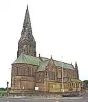
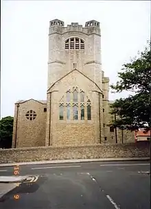
| Chapel of St Edmund and Trinity Centre | Gateshead | Church | 1837 | 26 April 1950 | NZ2570563135 54°57′44″N 1°36′00″W |
1277874 | 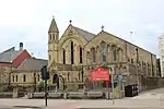 Chapel of St Edmund and Trinity Centre |
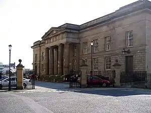
| Church of Holy Cross | Ryton, Gateshead | Parish Church | 13th century | 21 January 1949 | NZ1510064831 54°58′40″N 1°45′56″W |
1025160 | |
| Church of St Mary | Whickham, Gateshead | Sundial | 1651 | 1 February 1950 | NZ2097361358 54°56′47″N 1°40′27″W |
1185359 | 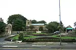 Church of St Mary |
| Church of St Mary | Gateshead | School | Early 19th century | 26 April 1950 | NZ2544563680 54°58′02″N 1°36′15″W |
1248544 | 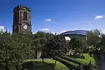 Church of St Mary |
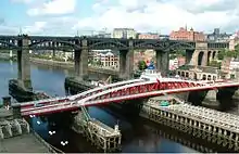
| High Level Bridge | River Tyne, Gateshead | Railway Bridge | 1849 | 26 April 1950 | NZ2518163634 54°58′00″N 1°36′30″W |
1248568 | |
| Monument to British Liberty | Gibside Estate, Gateshead | Column | 1750–57 | 1 February 1950 | NZ1794859132 54°55′36″N 1°43′17″W |
1025166 | 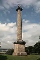 Monument to British Liberty |
| Old Hollinside | Gateshead | Fortified Manor House | 13th century | 1 February 1950 | NZ1855759920 54°56′01″N 1°42′43″W |
1025137 |  Old Hollinside |
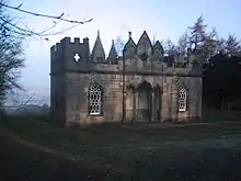
| The Chapel about 350 Metres West and 650 Metres South of Gibside Hall | Gibside Estate, Gateshead | Balustrade | Completed 1812 | 1 February 1950 | NZ1718758250 54°55′07″N 1°44′00″W |
1185345 | 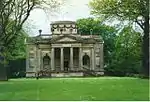 The Chapel about 350 Metres West and 650 Metres South of Gibside Hall |

Newcastle upon Tyne
| Name | Location | Type | Completed [note 1] | Date designated | Grid ref.[note 2] Geo-coordinates |
Entry number [note 3] | Image |
|---|---|---|---|---|---|---|---|
| Alderman Fenwick's House | Newcastle upon Tyne | House | c. 1987 | 14 June 1954 | NZ2504364201 54°58′18″N 1°36′37″W |
1024793 | 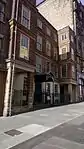 Alderman Fenwick's House |
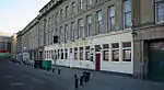
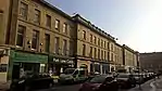
| Bessie Surtees House and Milbank House | Newcastle upon Tyne | House | 17th century | 14 June 1954 | NZ2516863845 54°58′07″N 1°36′30″W |
1024779 | |
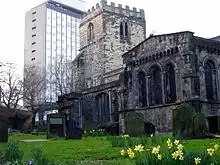
| Bishop's House | Newcastle upon Tyne | Bishops Palace | 1942 | 14 June 1954 | NZ1986765670 54°59′07″N 1°41′28″W |
1338212 | 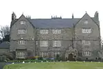 Bishop's House |
| Blackfriars East Range | Newcastle upon Tyne | Workshop | 1987 | 14 June 1954 | NZ2446464196 54°58′18″N 1°37′10″W |
1086979 | |
| Blackfriars South Range | Newcastle upon Tyne | Bench | 18th century | 14 June 1954 | NZ2444764182 54°58′18″N 1°37′11″W |
1087001 | |
| Blackfriars West Range | Newcastle upon Tyne | Workshop | 1978–80 | 14 June 1954 | NZ2442864200 54°58′19″N 1°37′12″W |
1355267 | |
| Cathedral of St Mary | Newcastle upon Tyne | Roman Catholic Cathedral | c. 1844 | 14 June 1954 | NZ2447663908 54°58′09″N 1°37′09″W |
1024913 | |
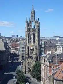
| Cathedral of St Nicholas | Newcastle upon Tyne | Cathedral | 1882 | 14 June 1954 | NZ2498964009 54°58′12″N 1°36′40″W |
1355309 | |
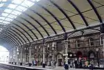
| Central Railway Station; Passenger Buildings and Train Shed with Platforms | Newcastle upon Tyne | Booking Office | 1845–50 | 14 June 1954 | NZ2461363825 54°58′06″N 1°37′01″W |
1355291 | |
| Church of All Saints | Newcastle upon Tyne | Church | 1954 | 14 June 1954 | NZ2526064017 54°58′12″N 1°36′25″W |
1106329 | 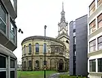 Church of All Saints |
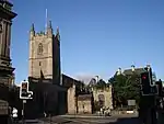
| Church of St Andrew | Newcastle upon Tyne | Parish Church | 12th century | 14 June 1954 | NZ2454464396 54°58′25″N 1°37′05″W |
1104887 | |
| Church of St Ann | Newcastle upon Tyne | Chapel of Ease | 1764-8 | 14 June 1954 | NZ2606164277 54°58′21″N 1°35′40″W |
1355222 | 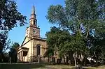 Church of St Ann |
| Church of St George | Newcastle upon Tyne | Church | 1888 | 14 June 1954 | NZ2551466798 54°59′42″N 1°36′10″W |
1024784 | 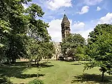 Church of St George |
| Church of St John the Baptist | Newcastle upon Tyne | Parish Church | 14th century | 14 June 1954 | NZ2470064011 54°58′12″N 1°36′57″W |
1024728 | |
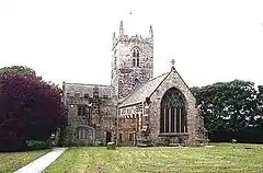
| Church of St Michael and All Angels | Newburn, Newcastle upon Tyne | Parish Church | 11th century | 21 October 1949 | NZ1667965368 54°58′57″N 1°44′27″W |
1186036 | 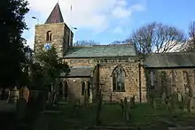 Church of St Michael and All Angels |
| Corner Tower | Newcastle upon Tyne | Turret | Medieval | 17 December 1971 | NZ2530764148 54°58′17″N 1°36′22″W |
1024903 | 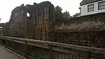 Corner Tower |
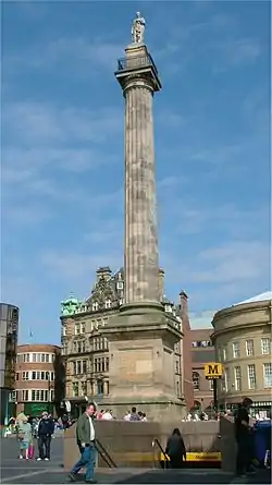
| Earl Grey Monument | Newcastle upon Tyne | Commemorative Monument | 1838 | 14 June 1954 | NZ2486164425 54°58′26″N 1°36′47″W |
1329931 | |
| East Front of Grainger Market | Newcastle upon Tyne | House | 1835 | 14 June 1954 | NZ2478664296 54°58′22″N 1°36′52″W |
1355243 | |
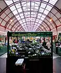
| Grainger Market | Newcastle upon Tyne | Market Hall | 1808 | 14 June 1954 | NZ2474964311 54°58′22″N 1°36′54″W |
1024866 | |
| Gunner Tower | Newcastle upon Tyne | Tower | late C13/early 14th century | 30 March 1987 | NZ2454163932 54°58′10″N 1°37′05″W |
1260201 |  Gunner Tower |
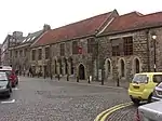
| Heron Pit Prison, Drawbridge Pit and other Under-buildings in Barbican | Newcastle upon Tyne | Privy House | Mid 13th century | 14 June 1954 | NZ2503463922 54°58′09″N 1°36′38″W |
1024937 | 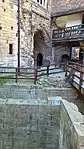 Heron Pit Prison, Drawbridge Pit and other Under-buildings in Barbican |
| High Level Bridge | Newcastle upon Tyne | Bridge | 1845-9 | 14 June 1950 | NZ2513063702 54°58′02″N 1°36′32″W |
1355287 | |
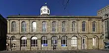
| Moot Hall | Newcastle upon Tyne | Moot Hall | Late C19, after 1877 | 17 December 1971 | NZ2511163866 54°58′08″N 1°36′33″W |
1116297 | |
| Numbers 11 to 43 (west Front of Grainger Market) | Newcastle upon Tyne | House | 1835 | 14 June 1954 | NZ2471164329 54°58′23″N 1°36′56″W |
1320114 | |
| Numbers 1–59 including Lake House, Garnett House, Hodgkin House, Gurney House and Embleton House | Newcastle upon Tyne | House | 1954 | 14 June 1954 | NZ2438364754 54°58′36″N 1°37′14″W |
1335857 | 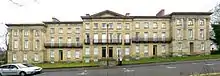 Numbers 1–59 including Lake House, Garnett House, Hodgkin House, Gurney House and Embleton House |
| Old Tyne Bridge | Newcastle upon Tyne | Bridge | Medieval | 14 June 1954 | NZ2516463790 54°58′05″N 1°36′31″W |
1323141 |  |
| Plummer Tower | Newcastle upon Tyne | House | Late 18th century | 17 December 1971 | NZ2520064416 54°58′25″N 1°36′28″W |
1024884 | |
| Roman Turret Opposite Number 800, Bishops House (Denton Hall) with Section of Hadrian's Wall | Newcastle upon Tyne | Wall | 122 | 17 December 1971 | NZ1985765549 54°59′03″N 1°41′28″W |
1355307 | 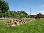 Roman Turret Opposite Number 800, Bishops House (Denton Hall) with Section of Hadrian's Wall |
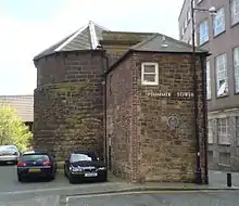
| Sallyport or Wall Knoll Tower | Newcastle upon Tyne | Tower | 14th century | 17 December 1971 | NZ2547464148 54°58′17″N 1°36′13″W |
1121526 | 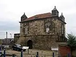 Sallyport or Wall Knoll Tower |
| Salters' Bridge (Tyne and Wear Bridge Number 077) | Newcastle upon Tyne | Bridge | Medieval | 30 March 1987 | NZ2547968542 55°00′39″N 1°36′11″W |
1299417 | .jpg.webp) Salters' Bridge (Tyne and Wear Bridge Number 077) |
| South Front of Grainger Market | Newcastle upon Tyne | Market Hall | 1835 | 14 June 1954 | NZ2472164263 54°58′21″N 1°36′55″W |
1355260 | |
| South Postern Tower facing the River, and Curtain Wall adjoining | Newcastle upon Tyne | Curtain Wall | 1168–78 | 14 June 1954 | NZ2509863837 54°58′07″N 1°36′34″W |
1024939 | 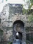 South Postern Tower facing the River, and Curtain Wall adjoining |
| Temple of Antenociticus | Newcastle upon Tyne | Vicus | c180 | 17 December 1971 | NZ2171164676 54°58′34″N 1°39′44″W |
1116382 | |
| The Barbican Walls between North Gate of Castle and Black Gate | Newcastle upon Tyne | Wall | Mid 13th century | 14 June 1954 | NZ2502663917 54°58′09″N 1°36′38″W |
1116305 | 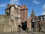 The Barbican Walls between North Gate of Castle and Black Gate |
| The Black Gate | Newcastle upon Tyne | Castle | Mid 13th century | 14 June 1954 | NZ2501363924 54°58′10″N 1°36′39″W |
1024936 | 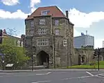 The Black Gate |
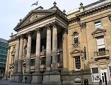
| The Guildhall and Merchants' Court | Newcastle upon Tyne | Exchange | 1655 | 14 June 1954 | NZ2521363833 54°58′07″N 1°36′28″W |
1120877 | |
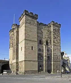
| The Castle Keep | Newcastle upon Tyne | Keep | 1168–78 | 14 June 1954 | NZ2504363870 54°58′08″N 1°36′37″W |
1320005 | |
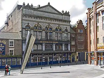
| The Tyne Theatre | Newcastle upon Tyne | Theatre | 1919 | 31 May 1974 | NZ2436264043 54°58′13″N 1°37′16″W |
1024741 | |
| The North Front of Grainger Market | Newcastle upon Tyne | Market Hall | 1835 | 14 June 1954 | NZ2477264365 54°58′24″N 1°36′52″W |
1024813 | |
| The Song School and Choir Vestry | Newcastle upon Tyne | Steps | 1736 | 30 March 1987 | NZ2501764002 54°58′12″N 1°36′39″W |
1024769 |  The Song School and Choir Vestry |
| Theatre Royal | Newcastle upon Tyne | Booking Office | 1837 | 14 June 1954 | NZ2494264306 54°58′22″N 1°36′43″W |
1145840 | |
| Theatre Royal Lounge and Restaurant; the Royal Public House | Newcastle upon Tyne | House | c. 1837 | 14 June 1954 | NZ2492464319 54°58′22″N 1°36′44″W |
1087023 | 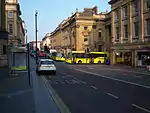 Theatre Royal Lounge and Restaurant; the Royal Public House |
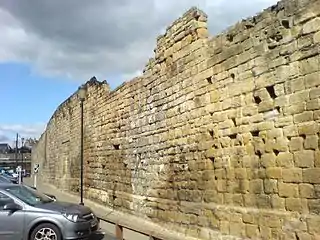
| Newcastle town wall | Newcastle upon Tyne | Town Wall | Late C13/early 14th century | 30 March 1987 | NZ2483263741 54°58′04″N 1°36′49″W |
1115451 | |
| Town Wall North of the Close and Breakneck Stairs | Newcastle upon Tyne | Town Wall | Late C13/early 14th century | 30 March 1987 | NZ2486763633 54°58′00″N 1°36′47″W |
1320260 | 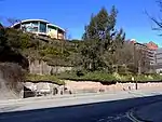 Town Wall North of the Close and Breakneck Stairs |
| Town Wall South of Numbers 74–80 Town Wall to Rear of Number 43 | Newcastle upon Tyne | Town Wall | Late 13th century | 17 December 1971 | NZ2447664391 54°58′25″N 1°37′09″W |
1355308 | 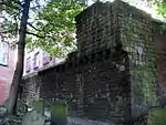 Town Wall South of Numbers 74–80 Town Wall to Rear of Number 43 |
| Town Wall to Rear of Numbers 1–25 Odd | Newcastle upon Tyne | Town Wall | Late 13th century | 30 March 1987 | NZ2455064433 54°58′26″N 1°37′05″W |
1355241 | 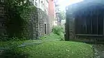 Town Wall to Rear of Numbers 1–25 Odd |
| Town Wall with Durham Tower | Newcastle upon Tyne | Tower | Late 13th century | 30 March 1987 | NZ2438264126 54°58′16″N 1°37′14″W |
1186222 | 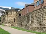 Town Wall with Durham Tower |
| Town Wall, with Morden, Heber and Ever Towers | Newcastle upon Tyne | Tower | Late 13th century | 17 December 1971 | NZ2440064280 54°58′21″N 1°37′13″W |
1355301 | 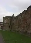 Town Wall, with Morden, Heber and Ever Towers |
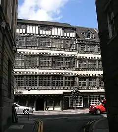
| Trinity House | Newcastle upon Tyne | House | Later than early 16th century | 14 June 1954 | NZ2534964008 54°58′12″N 1°36′20″W |
1024931 | .jpg.webp) Trinity House |
| Trinity House Banqueting Hall and Board Room | Newcastle upon Tyne | Banqueting House | 1721 | 14 June 1954 | NZ2536963995 54°58′12″N 1°36′19″W |
1024930 | .jpg.webp) Trinity House Banqueting Hall and Board Room |
| Trinity House Gate and Chapel | Newcastle upon Tyne | Courtyard | 17th century | 30 March 1987 | NZ2537064009 54°58′12″N 1°36′19″W |
1116418 | 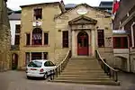 Trinity House Gate and Chapel |
| War Memorial in Public Gardens North of Church of St Thomas (Northumberland Fusiliers Memorial) | Newcastle upon Tyne | War Memorial | 1923 | 17 December 1971 | NZ2488464954 54°58′43″N 1°36′46″W |
1186201 | _-_geograph.org.uk_-_1766135.jpg.webp) War Memorial in Public Gardens North of Church of St Thomas (Northumberland Fusiliers Memorial) |
| 28 and 30 Close | Newcastle upon Tyne | House | 1954 | 14 June 1954 | NZ2505263771 54°58′05″N 1°36′37″W |
1024915 | 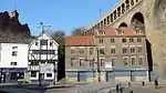 28 and 30 Close |
.jpg.webp)
.jpg.webp)
_Temple_of_Antenociticus_(2)_-_geograph.org.uk_-_837881.jpg.webp)
North Tyneside
| Name | Location | Type | Completed [note 1] | Date designated | Grid ref.[note 2] Geo-coordinates |
Entry number [note 3] | Image |
|---|---|---|---|---|---|---|---|
| Church of Holy Cross | Holy Cross, North Tyneside | Parish Church | 12th century | 18 August 1947 | NZ3052067204 54°59′55″N 1°31′28″W |
1299638 | 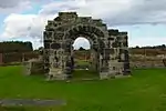 Church of Holy Cross |
| Church of St George | Cullercoats, North Tyneside | Parish Church | 1882-4 | 24 October 1950 | NZ3644270837 55°01′51″N 1°25′53″W |
1355000 |
South Tyneside
| Name | Location | Type | Completed [note 1] | Date designated | Grid ref.[note 2] Geo-coordinates |
Entry number [note 3] | Image |
|---|---|---|---|---|---|---|---|
| Church of Saint Nicholas | West Boldon, South Tyneside | Church | Early 13th century | 25 February 1949 | NZ3510461129 54°56′37″N 1°27′13″W |
1355070 | .jpg.webp) Church of Saint Nicholas |
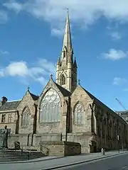
| Church of St Paul | South Tyneside | Church | 681-2 | 18 January 1949 | NZ3387965216 54°58′49″N 1°28′20″W |
1355091 | 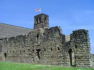 Church of St Paul |
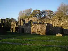
| Ruins of Jarrow Monastery | South Tyneside | Church | post Norman | 18 January 1949 | NZ3388165183 54°58′48″N 1°28′20″W |
1025198 | |
| Old Town Hall | South Tyneside | Market Cross | 1768 | 27 February 1950 | NZ3606467139 54°59′51″N 1°26′16″W |
1232158 | 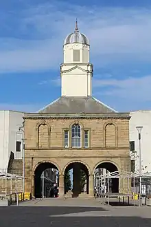 Old Town Hall |
Sunderland
| Name | Location | Type | Completed [note 1] | Date designated | Grid ref.[note 2] Geo-coordinates |
Entry number [note 3] | Image |
|---|---|---|---|---|---|---|---|
| Church of Holy Trinity | Sunderland | Parish Church | 1719 | 8 May 1950 | NZ4057557189 54°54′28″N 1°22′07″W |
1208056 | |
| Church of St Andrew | Roker, Sunderland | Parish Church | 1906-7 | 8 May 1950 | NZ4040759380 54°55′39″N 1°22′16″W |
1207113 | |
| Church of St Michael and All Angels | Sunderland | Parish Church | Late 12th century | 26 April 1950 | NZ3418149856 54°50′32″N 1°28′09″W |
1184780 | |
| Church of St Peter | Monkwearmouth, Sunderland | Abbey | 674-5 | 8 May 1950 | NZ4016857781 54°54′47″N 1°22′30″W |
1217958 | |
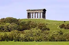
| Earl of Durham's Monument | Penshaw, Sunderland | Commemorative Monument | 1844 | 26 April 1950 | NZ3340054386 54°52′59″N 1°28′51″W |
1354965 | |
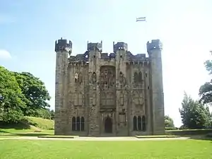
| Hylton Castle | Castletown, Sunderland | Fortified House | c. 1400 | 25 February 1949 | NZ3578358791 54°55′21″N 1°26′36″W |
1207073 | |
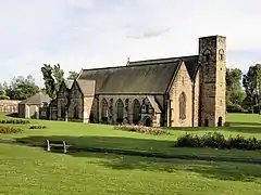
| Hylton Chapel | Castletown, Sunderland | Chapel | 12th century | 25 February 1949 | NZ3583258826 54°55′22″N 1°26′33″W |
1293281 | 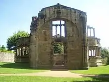 Hylton Chapel |
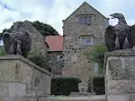
| Lodge to West of Washington Old Hall | Sunderland | House | Early 17th century | 19 December 1947 | NZ3107356538 54°54′09″N 1°31′01″W |
1185067 | |
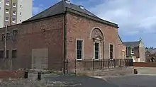
| Phoenix Lodge (freemason's Hall) | Sunderland | Freemasons Hall | 1778 | 20 June 1975 | NZ4039457228 54°54′29″N 1°22′17″W |
1279903 | |
| Washington Old Hall | Washington, Sunderland | House | Medieval | 19 December 1949 | NZ3110256555 54°54′10″N 1°30′59″W |
1354971 |
elevation.jpg.webp)
Notes
- The date given is the date used by Historic England as significant for the initial building or that of an important part in the structure's description.
- Sometimes known as OSGB36, the grid reference is based on the British national grid reference system used by the Ordnance Survey.
- The "List Entry Number" is a unique number assigned to each listed building and scheduled monument by Historic England.
References
- "Gateshead Listed Buildings". Gateshead Council. Retrieved 2009-02-14.
- "Listed Buildings". Newcastle City Council. Archived from the original on 2010-04-03. Retrieved 2009-02-14.
- "Listed buildings enquiries". North Tyneside Council. Retrieved 2009-02-14.
- "Listed buildings". South Tyneside Council. Archived from the original on January 22, 2009. Retrieved 2009-02-14.
- "Listed Buildings – Search Criteria". Sunderland City Council. Archived from the original on 2009-04-21. Retrieved 2009-02-14.
External links
![]() Media related to Grade I listed buildings in Tyne and Wear at Wikimedia Commons
Media related to Grade I listed buildings in Tyne and Wear at Wikimedia Commons