Grade I listed buildings in West Yorkshire
There are over 9,000 Grade I listed buildings in England. This page is a list of these buildings in the county of West Yorkshire, by metropolitan district.
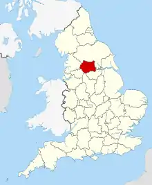
West Yorkshire shown within England
Bradford
| Name | Location | Type | Completed [note 1] | Date designated | Grid ref.[note 2] Geo-coordinates |
Entry number [note 3] | Image |
|---|---|---|---|---|---|---|---|
| Heathcote | Ilkley | House | 1906–08 | 12 December 2014 | SE1085747608 53°55′28″N 1°50′10″W |
1133518 | |
| 2 Pairs of Gate Piers and Linking Walls with Summer-house Attached to Rear of Farfield Hall | Addingham, Ilkley | Gate Pier | Early 18th century | 10 September 1954 | SE0773651653 53°57′39″N 1°53′01″W |
1133451 |  |
| Church of St Peter | Addingham, Ilkley | Cross | Anglo-Saxon | 10 September 1954 | SE0852249696 53°56′36″N 1°52′18″W |
1133457 | 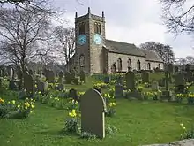 Church of St Peter |
| Farfield Hall | Addingham, Ilkley | Kitchen | 16th century or 17th century | 10 September 1954 | SE0773951619 53°57′38″N 1°53′01″W |
1133450 | .jpg.webp) Farfield Hall |
| Bingley Five Rise Locks with Overflow Channel | Bingley | Steps | c. 1773 | 9 August 1966 | SE1075839959 53°51′21″N 1°50′17″W |
1314303 |  Bingley Five Rise Locks with Overflow Channel |
| Burley House | Burley in Wharfedale, Ilkley | Country House | Late 18th century | 18 July 1949 | SE1702746105 53°54′39″N 1°44′32″W |
1199636 |  Burley House |
| Haworth Parsonage (Brontë Museum) | Haworth | Vicarage | 1779 | 23 February 1955 | SE0290937214 53°49′52″N 1°57′26″W |
1313933 |  Haworth Parsonage (Brontë Museum) |
| 3 Stone Crosses previously south of the Church of All Saints, now inside | Ilkley | Cross | Early C9 | 20 May 1976 | SE1164847813 53°55′35″N 1°49′27″W |
1133507 | .jpg.webp) 3 Stone Crosses previously south of the Church of All Saints, now inside |
| Manor House | Ilkley | House | Earlier than 16th century | 18 July 1949 | SE1160647869 53°55′37″N 1°49′29″W |
1133505 |  Manor House |
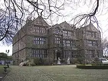
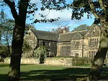
| Myddelton Lodge (St Paul's Retreat) | Ilkley | Detached House | 16th century | 18 July 1949 | SE1099549064 53°56′15″N 1°50′02″W |
1133521 | .jpg.webp) Myddelton Lodge (St Paul's Retreat) |
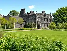
| East Riddlesden Hall | Riddlesden, Keighley | House | Pre 1640 | 23 February 1955 | SE0789342064 53°52′29″N 1°52′53″W |
1283478 | |
| West Riddlesden Hall | Riddlesden, Keighley | House | 1687 | 23 February 1955 | SE0727042690 53°52′49″N 1°53′27″W |
1313939 | |
| Bolling Hall (museum) | Bowling | Hall House | 14th century Probably | 4 September 1952 | SE1730631431 53°46′44″N 1°44′20″W |
1299398 | 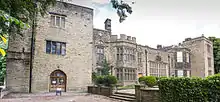 Bolling Hall (museum) |
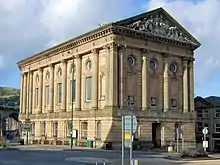
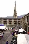
| Bradford City Hall | Bradford city centre | Town Hall | 1869-1873 | 14 June 1963 | SE1635132912 53°47′32″N 1°45′12″W |
1133675 | |
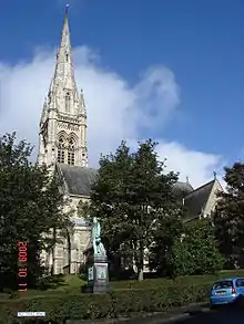
| Cathedral Church of St Peter | Bradford city centre | Cathedral | 1919 | 4 September 1952 | SE1671533264 53°47′44″N 1°44′52″W |
1133250 | |
| The Wool Exchange | Bradford city centre | Wool Exchange | 1864 to 1867 | 14 June 1963 | SE1640233128 53°47′39″N 1°45′09″W |
1132985 | |
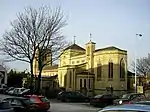
| Congregational Church (including Salt Family Mausoleum to South) | Saltaire, Shipley | Bust | 1858-9 | 22 November 1966 | SE1385838107 53°50′21″N 1°47′27″W |
1314229 |  Congregational Church (including Salt Family Mausoleum to South) |
| Upper Headley Hall | Thornton | House | 1589 | 4 September 1952 | SE0978532157 53°47′08″N 1°51′11″W |
1111890 |  Upper Headley Hall |
| Courtyard Entrance and Walling at Upper Headley Hall | Thornton | Gate | Dated 1669 | 4 September 1952 | SE0979032141 53°47′08″N 1°51′10″W |
1133129 |  Courtyard Entrance and Walling at Upper Headley Hall |
| Barn at Upper Headley Hall | Thornton | Barn | Late 16th century or early 17th century | 4 September 1952 | SE0976332171 53°47′09″N 1°51′12″W |
1133130 | |
| Tong Hall | Tong | House | C15/C16 | 4 September 1952 | SE2180930710 53°46′20″N 1°40′14″W |
1314140 | 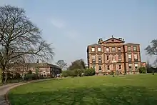 Tong Hall |
| Church of St James | Tong | Church | Medieval | 4 September 1952 | SE2191730542 53°46′15″N 1°40′08″W |
1133660 | 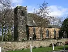 Church of St James |

Calderdale


Kirklees
| Name | Location | Type | Completed [note 1] | Date designated | Grid ref.[note 2] Geo-coordinates |
Entry number [note 3] | Image |
|---|---|---|---|---|---|---|---|
| Church of St Michael | Emley | Church | Early Medieval | 29 March 1965 | SE2449413320 53°36′57″N 1°37′52″W |
1135290 | 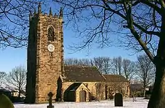 Church of St Michael |
| Church of All Hallows | Kirkburton | Church | c. 1200 | 23 June 1965 | SE1980212497 53°36′31″N 1°42′08″W |
1313318 |  Church of All Hallows |
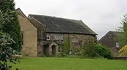
| Woodsome Hall | Fenay Bridge, Huddersfield[1] | House | ? | 23 June 1965 | SE1802614414 53°37′33″N 1°43′44″W |
1184158 | |
| Banney Royd | Edgerton, Huddersfield | House | 1900-1 | 29 September 1978 | SE1260018100 53°39′33″N 1°48′39″W |
1134184 | |
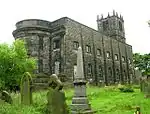
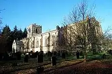
| Church of All Hallows | Almondbury | Church | 13th century | 3 March 1952 | SE1683315058 53°37′54″N 1°44′49″W |
1225096 | .jpg.webp) Church of All Hallows |
| Church of All Saints | Batley | Church | 13th century | 29 March 1963 | SE2413024457 53°42′58″N 1°38′09″W |
1134620 |  Church of All Saints |
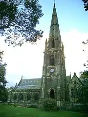
| Church of St Michael and All Angels | Thornhill | Church | 15th century | 30 June 1949 | SE2533718862 53°39′56″N 1°37′05″W |
1200754 | 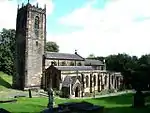 Church of St Michael and All Angels |
| Oakwell Hall Including Boundary Wall | Birstall | Hall House | 1583 | 29 March 1963 | SE2174627114 53°44′24″N 1°40′18″W |
1134609 | |
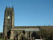
| Huddersfield railway station | Huddersfield town centre | Gate | 1846-50 | 3 March 1952 | SE1431316909 53°38′55″N 1°47′06″W |
1277385 | |
| Lees Hall | Thornhill Lees, Dewsbury | House | 1530 | 30 June 1949 | SE2330919992 53°40′33″N 1°38′55″W |
1313642 | 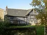 Lees Hall |

Leeds
| Name | Location | Type | Completed [note 1] | Date designated | Grid ref.[note 2] Geo-coordinates |
Entry number [note 3] | Image |
|---|---|---|---|---|---|---|---|
| Church of All Hallows | Bardsey | Parish Church | 850-950 | 30 March 1966 | SE3656143123 53°52′59″N 1°26′43″W |
1135652 | |
| Open Temple at West End of Quarter Mile Walk in Bramham Park | Bramham Park, Bramham | Garden Temple | Early 18th century | 30 March 1966 | SE4046341351 53°52′00″N 1°23′10″W |
1313176 | .jpg.webp) Open Temple at West End of Quarter Mile Walk in Bramham Park |
| Retaining Wall to South Terrace and Eastern Part of Garden Terminating at the Four Faces Avenue | Bramham Park, Bramham | Garden Wall | 1727-28 | 22 July 1986 | SE4061341155 53°51′54″N 1°23′02″W |
1066000 | |
| Stone Surround to T-shaped Pond | Bramham Park, Bramham | Garden Wall | 1728 | 2 September 1952 | SE4063641202 53°51′56″N 1°23′01″W |
1135662 | |
| The Rotunda in the Black Fen Pleasure Ground | Bramham Park, Bramham | Garden Temple | Mid 18th century | 1 May 1960 | SE4136040835 53°51′44″N 1°22′21″W |
1066002 | 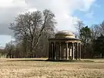 The Rotunda in the Black Fen Pleasure Ground |
| Bramham Park | Bramham Park, Bramham | Country House | 1700-10 | 2 September 1952 | SE4084641724 53°52′12″N 1°22′49″W |
1135635 | |
| Chapel at North End of Terrace to Rear of Bramham Park | Bramham Park, Bramham | Summerhouse/Watertower | 1750-62 | 30 March 1966 | SE4077541810 53°52′15″N 1°22′53″W |
1135640 | 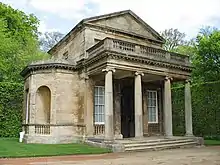 Chapel at North End of Terrace to Rear of Bramham Park |
| Gatepiers at Entrance to Forecourt of Bramham Park with Attached Retaining Wall | Bramham Park, Bramham | Gate | Early 18th century | 30 March 1966 | SE4093941778 53°52′14″N 1°22′44″W |
1135636 | |
| Gothic Temple Approximately 370 Metres South of Bramham Park House | Bramham Park, Bramham | Garden Temple | 18th century | 2 September 1952 | SE4080141343 53°52′00″N 1°22′52″W |
1200485 | .jpg.webp) Gothic Temple Approximately 370 Metres South of Bramham Park House |
| Obelisk Pond and the Great Cascade Approximately 300 Metres South of Bramham Park House | Bramham Park, Bramham | Garden Pool | 1724-5 | 30 March 1966 | SE4099441492 53°52′05″N 1°22′41″W |
1300743 |  Obelisk Pond and the Great Cascade Approximately 300 Metres South of Bramham Park House |
| Parterre to West of Bramham Park House with 2 Pillars and 6 Urns | Bramham Park, Bramham | Terrace | Early 18th century | 3 December 1986 | SE4078641711 53°52′12″N 1°22′52″W |
1135639 | |
| Stable Block Forming South Side of Forecourt to Bramham Park | Bramham Park, Bramham | House | Early 18th century | 30 March 1966 | SE4092441724 53°52′12″N 1°22′45″W |
1135638 |  Stable Block Forming South Side of Forecourt to Bramham Park |
| T Pond at Junction of Walks Approximately 350 Metres South West of Bramham Park House | Bramham Park, Bramham | Formal Garden | 1728 | 30 March 1966 | SE4066241414 53°52′02″N 1°22′59″W |
1135642 | |
| Puritan Chapel | Bramhope | Nonconformist Chapel | 1649 | 22 November 1966 | SE2490543592 53°53′17″N 1°37′21″W |
1261799 | .jpg.webp) Puritan Chapel |
| Lumb Hall | Drighlington | Clothiers House | c. 1640 | 7 August 1964 | SE2270829359 53°45′36″N 1°39′25″W |
1135127 | 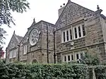 Lumb Hall |
| Church of All Saints | Harewood Park, Harewood | Church | 1775 | 30 March 1966 | SE3137345003 53°54′01″N 1°31′26″W |
1266157 | |
| Harewood Castle | Harewood Park, Harewood | Castle | Mid 14th century | 30 March 1966 | SE3217845622 53°54′21″N 1°30′42″W |
1226242 | |
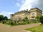
| Harewood House | Harewood Park, Harewood | Country House | 1759-71 | 30 March 1960 | SE3116044628 53°53′49″N 1°31′38″W |
1225861 | |
| Stables Approximately 200 Metres to South West of Harewood House | Harewood Park, Harewood | Stables | 1755-58 | 30 March 1966 | SE3109644401 53°53′41″N 1°31′42″W |
1266160 |  Stables Approximately 200 Metres to South West of Harewood House |
| Church of St Mary | Kippax | Church | Anglo Saxon | 15 September 1987 | SE4168430329 53°46′04″N 1°22′09″W |
1237399 |  Church of St Mary |
| Church of All Saints | Ledsham | Church | Saxon | 3 February 1967 | SE4565029774 53°45′44″N 1°18′32″W |
1237404 |  Church of All Saints |
| Ledston Lodge | Ledston Park, Ledsham | House | 17th century | 3 February 1967 | SE4501230906 53°46′21″N 1°19′07″W |
1264072 |  Ledston Lodge |
| Barn Forming East Side of Stable Yard Approximately 100 Metres East of Ledston Hall | Ledston | Barn | 17th century | 4 July 1952 | SE4366528907 53°45′17″N 1°20′21″W |
1237515 | |
| Entrance Gates and Lodges | Ledston | Gate Lodge | Early 18th century | 4 July 1952 | SE4358528887 53°45′16″N 1°20′26″W |
1264075 | |
| Ledston Hall | Ledston | Country House | c. 1200 | 4 July 1952 | SE4354628933 53°45′18″N 1°20′28″W |
1237569 |  Ledston Hall |
| Stable Block Approximately 50 Metres East of Ledston Hall | Ledston | Stables | 17th century | 4 July 1952 | SE4362928920 53°45′17″N 1°20′23″W |
1247674 | |
| The Town Hall | Morley town centre | Town Hall | 1892-95 | 12 March 1980 | SE2633527783 53°44′45″N 1°36′08″W |
1135112 | |
| Parish Church of All Saints | Otley town centre | Church | Saxon | 30 July 1951 | SE2015745363 53°54′15″N 1°41′41″W |
1200290 | |
| Calverley Old Hall | Calverley | House | 14th - 16th century | 25 May 1966 | SE2079636877 53°49′40″N 1°41′08″W |
1265966 | |
| Church of St John the Evangelist | Leeds city centre | Church | 1632-1634 | 26 September 1963 | SE3024333855 53°48′00″N 1°32′32″W |
1375157 | |
| Church of St John the Baptist | Adel, Leeds | Anglican Church | 1150-1170 | 26 September 1963 | SE2746240235 53°51′27″N 1°35′02″W |
1255610 | 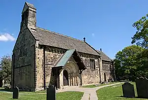 Church of St John the Baptist |
| Church of St Mary | Whitkirk | Anglican Church | 15th century | 26 September 1963 | SE3635033582 53°47′50″N 1°26′59″W |
1375130 | |
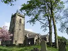
| Church of St Oswald | Guiseley | Church | 11th century | 19 October 1962 | SE1941542145 53°52′31″N 1°42′22″W |
1135598 | |
| Church of St Oswald | Methley | Parish Church | 14th century | 5 June 1964 | SE3910826620 53°44′04″N 1°24′31″W |
1135664 |  Church of St Oswald |
| Church of St Saviour | Richmond Hill, Leeds | Anglican Church | 1842-1845 | 26 September 1963 | SE3129032944 53°47′31″N 1°31′35″W |
1375400 | |
| Church of the Epiphany | Gipton, Leeds | Anglican Church | 1936-1938 | 25 June 1993 | SE3356435305 53°48′47″N 1°29′30″W |
1255904 | |
| Leeds City Markets | Leeds city centre | Market Hall | c. 1875 | 8 May 1973 | SE3045033526 53°47′50″N 1°32′21″W |
1255765 | |
| Leeds Corn Exchange | Leeds city centre | Shopping Precinct | 1989-1990 | 19 October 1951 | SE3039333387 53°47′45″N 1°32′24″W |
1255771 | |
| Fulneck Moravian Church and Attached Ranges to Either Side including the Boys' School and Girls' School | Fulneck Moravian Settlement, Pudsey | Moravian Settlement | 1746-48 | 17 May 1972 | SE2221031999 53°47′02″N 1°39′52″W |
1135096 | 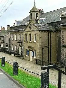 Fulneck Moravian Church and Attached Ranges to Either Side including the Boys' School and Girls' School |
| Holy Trinity Church | Leeds city centre | Anglican Church | 1721-1727 | 26 September 1963 | SE3016433415 53°47′46″N 1°32′37″W |
1255870 | |
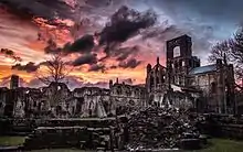
| Kirkstall Abbey | Kirkstall, Leeds | Abbey | 1152-1182 | 26 September 1963 | SE2597736085 53°49′13″N 1°36′25″W |
1256668 | |
| Leeds General Infirmary | Leeds city centre | Hospital | 1863-68 | 8 October 1970 | SE2967233991 53°48′05″N 1°33′03″W |
1256242 | |
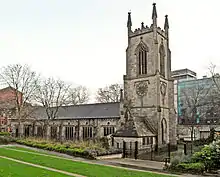
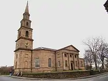
| Leeds Minster | Leeds city centre | Church | 1839-1841 | 26 September 1963 | SE3065833301 53°47′42″N 1°32′10″W |
1375046 | |
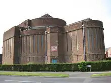
| Temple Mill | Holbeck, Leeds | Fireproof Factory | 1838-1840 | 19 October 1951 | SE2952532691 53°47′23″N 1°33′12″W |
1375162 | |
| Temple Newsam House | Temple Newsam, Leeds | Country House | Early 16th century | 19 October 1951 | SE3571232108 53°47′03″N 1°27′34″W |
1255943 | |
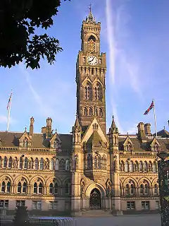
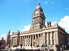
| Leeds Town Hall | Leeds city centre | Town Hall | 1853-1858 | 19 October 1951 | SE2975233866 53°48′01″N 1°32′59″W |
1255772 |

.jpg.webp)
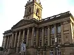


_012.jpg.webp)

Wakefield
| Name | Location | Type | Completed [note 1] | Date designated | Grid ref.[note 2] Geo-coordinates |
Entry number [note 3] | Image |
|---|---|---|---|---|---|---|---|
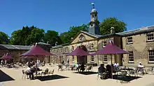
| Ackworth School (that Part Comprising Centre Block & East and West Wings, Shed Court, Main Entrance) | Low Ackworth, Ackworth | Courtyard | 1786 | 6 June 1952 | SE4409117122 53°38′56″N 1°20′04″W |
1025067 | .jpg.webp) Ackworth School (that Part Comprising Centre Block & East and West Wings, Shed Court, Main Entrance) |
| Church of St Mary | Badsworth | Parish Church | 15th century | 25 March 1968 | SE4633214972 53°37′45″N 1°18′03″W |
1052219 | 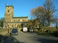 Church of St Mary |
| Church of St Luke and All Saints | Darrington | Church | Norman | 11 December 1967 | SE4850820179 53°40′33″N 1°16′02″W |
1313210 | 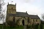 Church of St Luke and All Saints |
| Church of St Peter and St Leonard | Horbury | Church | Saxon | 15 February 1966 | SE2951518368 53°39′39″N 1°33′17″W |
1135508 | |
| Horbury Hall | Horbury | Hall House | 1478-92 | 15 February 1966 | SE2954218336 53°39′38″N 1°33′16″W |
1135510 | |
| Kettlethorpe Hall | Kettlethorpe | House | 1727 | 14 July 1953 | SE3330016698 53°38′45″N 1°29′52″W |
1259736 | 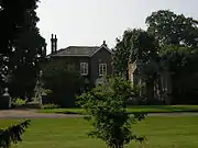 Kettlethorpe Hall |
| Church of St Michael and Our Lady (Wragby Parish Church) | Nostell Park, Nostell | Church | Dated 1533 | 25 March 1968 | SE4077617299 53°39′02″N 1°23′04″W |
1253565 |  Church of St Michael and Our Lady (Wragby Parish Church) |
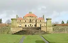
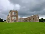
| Nostell Priory | Nostell Park, Nostell | Country House | 1736-50 | 6 June 1952 | SE4040917526 53°39′10″N 1°23′24″W |
1262071 | |
| Stables at Nostell Priory | Nostell Park, Nostell | Garage | 1952 | 6 June 1952 | SE4047817405 53°39′06″N 1°23′21″W |
1253558 | |
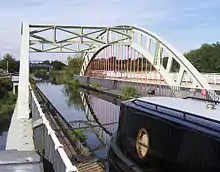
| Stanley Ferry Aqueduct | Normanton | Aqueduct | 1837-39 | 9 October 1987 | SE3558023028 53°42′09″N 1°27′45″W |
1261690 | |
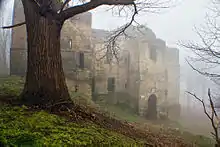
| The Hermitage, under the Infirmary. | Pontefract | Hermitage | Medieval | 15 November 1988 | SE4566721793 53°41′26″N 1°18′36″W |
1135427 | |
| Church of St Peter | Felkirk, South Hiendley | Parish Church | Norman | 25 March 1968 | SE3868912603 53°36′31″N 1°25′00″W |
1265442 | 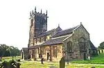 Church of St Peter |
| Church of All Saints | South Kirkby | Parish Church | 13th century | 25 March 1968 | SE4529711071 53°35′39″N 1°19′02″W |
1227519 | 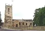 Church of All Saints |
| Frieston's Hospital | Heath Common, Wakefield | Almshouse | c. 1595 | 14 February 1952 | SE3607220896 53°41′00″N 1°27′19″W |
1313217 | 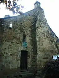 Frieston's Hospital |
| Heath Hall | Heath Common, Wakefield | Country House | c. 1709 | 14 February 1952 | SE3555820186 53°40′37″N 1°27′47″W |
1200238 | 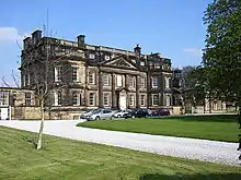 Heath Hall |
| Flanking Screen Walls and Gate Piers Attached to West Front of Heath Hall Linking East and West Pavilions | Heath Common, Wakefield | Gate Pier | c. 1767 | 14 February 1952 | SE3557720156 53°40′36″N 1°27′46″W |
1200345 | |
| The Brewhouse and East Pavilion at Heath Hall | Heath Common, Wakefield | Apartment | 1982-84 | 14 February 1952 | SE3559320155 53°40′36″N 1°27′46″W |
1313191 | .jpg.webp) The Brewhouse and East Pavilion at Heath Hall |
| The Stable House, Heath Hall | Heath Common, Wakefield | Bothy | c. 1754 | 14 February 1952 | SE3554720243 53°40′39″N 1°27′48″W |
1135583 | .jpg.webp) The Stable House, Heath Hall |
| The West Pavilion, Heath Hall | Heath Common, Wakefield | Flats | 1986 | 14 February 1952 | SE3554820210 53°40′38″N 1°27′48″W |
1200273 |  The West Pavilion, Heath Hall |
| Church of St Peter | Woolley | Church | 15th century | 22 November 1966 | SE3193613016 53°36′46″N 1°31′08″W |
1200723 |  Church of St Peter |
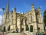
| Cathedral Church of All Saints | Wakefield city centre | Cathedral | Early 15th century | 14 July 1953 | SE3333220841 53°40′59″N 1°29′49″W |
1258237 | |
| Chapel of St Mary on East Side of Wakefield Bridge | Wakefield city centre | Bridge Chapel | c. 1350 | 14 July 1953 | SE3382320140 53°40′36″N 1°29′22″W |
1258242 | |
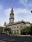
| County Hall (offices of West Yorkshire County Council) | Wakefield city centre | County Hall | 1894-98 | 30 March 1971 | SE3295521008 53°41′04″N 1°30′09″W |
1242349 | %252C_Wood_Street%252C_Wakefield.jpg.webp) County Hall (offices of West Yorkshire County Council) |
| Town Hall | Wakefield city centre | Local Government Office | 1971 | 30 March 1971 | SE3302720927 53°41′02″N 1°30′05″W |
1258995 | |
| Wakefield Bridge | Wakefield city centre | Bridge | Early-Mid 14th century | 14 July 1953 | SE3381020135 53°40′36″N 1°29′23″W |
1273508 | 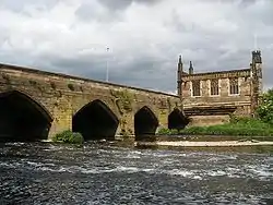 Wakefield Bridge |


See also
- Category:Grade I listed buildings in West Yorkshire
- Grade II* listed buildings in West Yorkshire
Notes
- The date given is the date used by Historic England as significant for the initial building or that of an important part in the structure's description.
- Sometimes known as OSGB36, the grid reference is based on the British national grid reference system used by the Ordnance Survey.
- The "List Entry Number" is a unique number assigned to each listed building and scheduled monument by Historic England.
References
External links
![]() Media related to Grade I listed buildings in West Yorkshire at Wikimedia Commons
Media related to Grade I listed buildings in West Yorkshire at Wikimedia Commons
This article is issued from Wikipedia. The text is licensed under Creative Commons - Attribution - Sharealike. Additional terms may apply for the media files.