Grade I listed buildings in Hertfordshire
There are over 9,000 Grade I listed buildings in England. This page is a list of these buildings in the county of Hertfordshire, organised by district.
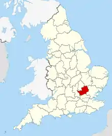
Hertfordshire shown in England
Broxbourne
| Name | Location | Type | Completed [note 1] | Date designated | Grid ref.[note 2] Geo-coordinates |
Entry number [note 3] | Image |
|---|---|---|---|---|---|---|---|
| Church of St Mary | Cheshunt | Church | 1418-1448 | 11 June 1954 | TL3491502415 51°42′15″N 0°02′56″W |
1172977 |  Church of St Mary |
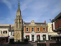
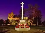
| Eleanor Cross | Waltham Cross | Eleanor Cross | 1291 | 11 June 1954 | TL3607300394 51°41′09″N 0°01′59″W |
1173222 | |
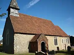
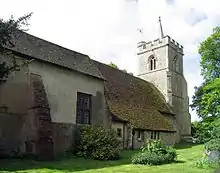
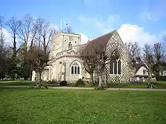
| Parish Church of St Augustine | Broxbourne | Parish Church | C15-C16 | 13 April 1961 | TL3715906947 51°44′40″N 0°00′53″W |
1100545 | 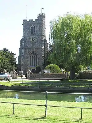 Parish Church of St Augustine |
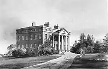
| Wormleybury | Wormley | House | 1734 | 13 April 1961 | TL3557505783 51°44′04″N 0°02′17″W |
1100541 |
Dacorum
| Name | Location | Type | Completed [note 1] | Date designated | Grid ref.[note 2] Geo-coordinates |
Entry number [note 3] | Image |
|---|---|---|---|---|---|---|---|
| Church of St John the Baptist (Church of England) | Aldbury | Parish Church | Romanesque | 30 November 1966 | SP9635112471 51°48′09″N 0°36′15″W |
1078047 | 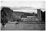 Church of St John the Baptist (Church of England) |
| Berkhamsted School Old Building | Berkhamsted | School | 1544 | 29 July 1950 | SP9939007814 51°45′37″N 0°33′41″W |
1342152 | 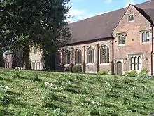 Berkhamsted School Old Building |
| Beechwood Park School and Walls of Walled Garden adjoining | Beechwood Park, Flamstead | House | c. 1664 | 22 October 1952 | TL0453514478 51°49′09″N 0°29′05″W |
1100376 | 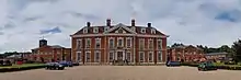 Beechwood Park School and Walls of Walled Garden adjoining |
| Church of St Leonard | Flamstead | Parish Church | Early 12th century | 26 January 1967 | TL0788714548 51°49′09″N 0°26′10″W |
1172799 | 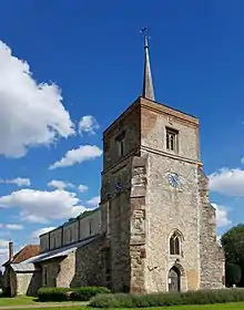 Church of St Leonard |
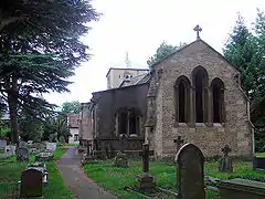
| Church of St John the Baptist | Great Gaddesden | Parish Church | Early 12th century | 26 January 1967 | TL0286811263 51°47′26″N 0°30′36″W |
1101262 | 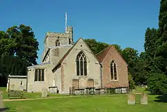 Church of St John the Baptist |
| Ashridge Management College | Little Gaddesden | House | 1884 | 14 May 1952 | SP9939012181 51°47′58″N 0°33′36″W |
1348442 | |
| Church of St Peter and St Paul (Church of England) | Little Gaddesden | Urn | 1671 | 30 November 1966 | SP9978813820 51°48′51″N 0°33′14″W |
1100424 |  Church of St Peter and St Paul (Church of England) |
| Church of Saint Mary | Northchurch | Church | Saxon | 29 July 1950 | SP9744008833 51°46′11″N 0°35′21″W |
1348470 | 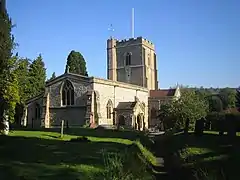 Church of Saint Mary |
| Church of St Peter St Paul (Church of England) | Tring | Parish Church | 13th century | 21 September 1951 | SP9243611495 51°47′40″N 0°39′40″W |
1084356 | |
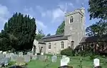
| Church of St Mary (Church of England) | Puttenham | Parish Church | Early 14th century | 30 November 1966 | SP8852014927 51°49′33″N 0°43′01″W |
1076690 |  Church of St Mary (Church of England) |
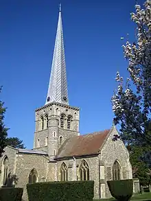
| Church of St Mary | Hemel Hempstead | Church | 1140-80 | 18 June 1948 | TL0550307813 51°45′33″N 0°28′22″W |
1078099 | |
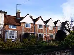
| 130–136 Piccott's End | Piccotts End | Row | 15th century | 20 May 1954 | TL0513709107 51°46′15″N 0°28′40″W |
1342208 |
East Hertfordshire
| Name | Location | Type | Completed [note 1] | Date designated | Grid ref.[note 2] Geo-coordinates |
Entry number [note 3] | Image |
|---|---|---|---|---|---|---|---|
| Church of St George | Anstey | Parish Church | Late 12th century | 22 February 1967 | TL4042832890 51°58′36″N 0°02′35″E |
1101870 | 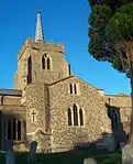 Church of St George |
| Parish Church of St Lawrence | Ardeley | Parish Church | 13th century or earlier | 22 February 1967 | TL3081727138 51°55′39″N 0°05′56″W |
1174231 | 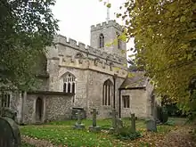 Parish Church of St Lawrence |
| Parish Church of St Mary | Aspenden | Parish Church | 11th century | 22 February 1967 | TL3536428392 51°56′15″N 0°01′56″W |
1347966 | 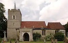 Parish Church of St Mary |
| Aston Bury Manor | Aston | Manor House | Mid 17th century | 20 October 1952 | TL2760621702 51°52′45″N 0°08′51″W |
1174988 | |
| Parish Church of St Peter | Benington | Parish Church | Late 13th century or early 14th century | 24 November 1966 | TL2969223579 51°53′44″N 0°07′00″W |
1101403 | 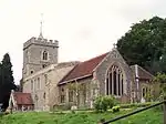 Parish Church of St Peter |
| Remains of Benington Castle (in Grounds of the Lordship 15 Metres to South East of House) | Benington | Castle | 1130S | 24 November 1966 | TL2968023633 51°53′46″N 0°07′00″W |
1175349 |  Remains of Benington Castle (in Grounds of the Lordship 15 Metres to South East of House) |
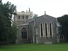
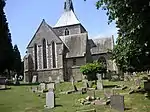
| Church of St Michael | Bishop's Stortford | Church | Early 15th century | 18 October 1949 | TL4862321336 51°52′15″N 0°09′27″E |
1101613 | 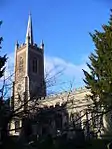 Church of St Michael |
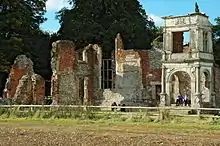
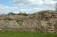
| Remains of Waytemore Castle | Bishop's Stortford | Keep | 12th century | 18 October 1949 | TL4897621447 51°52′18″N 0°09′45″E |
1101603 | 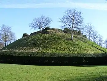 Remains of Waytemore Castle |
| Parish Church of St Mary the Virgin | Braughing | Church | 1971 | 22 February 1967 | TL3961925204 51°54′28″N 0°01′42″E |
1347516 |  Parish Church of St Mary the Virgin |
| Brent Pelham Hall, Gate Piers and Boundary Wall from North West Front of Hall, turning to South West and then South East to Gate | Brent Pelham | House | Late 17th century | 19 October 1951 | TL4335830863 51°57′28″N 0°05′06″E |
1101916 |  |
| Church of St Peter | Buntingford | Church | c. 1615 | 22 February 1967 | TL3630729324 51°56′45″N 0°01′06″W |
1348000 | 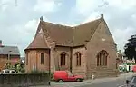 Church of St Peter |
| The Lordship | Cottered | Farmhouse | Early-mid 15th century | 19 October 1951 | TL3189829194 51°56′44″N 0°04′57″W |
1348017 | |
| Johnston Monument at Gilston Parish Church at South West Corner of Churchyard | Gilston | Commemorative Monument | 1923 | 19 September 1984 | TL4395213512 51°48′06″N 0°05′11″E |
1101277 | |
| Parish Church of St Mary | Gilston | Parish Church | Early 13th century | 24 January 1967 | TL4398113526 51°48′07″N 0°05′12″E |
1308248 | .jpg.webp) Parish Church of St Mary |
| Balls Park | Hertford | House | Early 18th century | 10 February 1950 | TL3371111928 51°47′24″N 0°03′46″W |
1269013 | |
| Church of St Leonard | Bengeo, Hertford | Church | 1695 | 10 February 1950 | TL3301813638 51°48′20″N 0°04′20″W |
1268717 | |
| Friends Meeting House | Hertford | Friends Meeting House | 1670 | 9 May 2019 | TL3281212705 51°47′50″N 0°04′32″W |
1268759 | 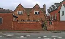 Friends Meeting House |
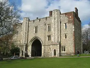
| Gatehouse to Hertford Castle | Hertford | Castle | Later | 10 February 1950 | TL3245712465 51°47′43″N 0°04′50″W |
1269027 | |
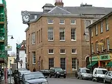
| Shire Hall | Hertford | Assembly Rooms | 1767-1771 | 10 February 1950 | TL3267212596 51°47′47″N 0°04′39″W |
1268930 | |
| Church of St Mary Little Hormead | Little Hormead | Parish Church | 11th century | 22 February 1967 | TL3984929104 51°56′34″N 0°01′59″E |
1176874 | 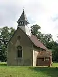 Church of St Mary Little Hormead |
| Hunsdon House | Hunsdon | Country House | Mid 15th century | 4 December 1951 | TL4190412744 51°47′43″N 0°03′23″E |
1347687 | |
| Parish Church of St Dunstan | Hunsdon | Parish Church | Early 14th century | 24 January 1967 | TL4181512710 51°47′42″N 0°03′18″E |
1101973 | 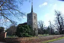 Parish Church of St Dunstan |
| Parish Church of St Cecilia | Church End, Little Hadham | Church | Medieval | 22 February 1967 | TL4462022778 51°53′05″N 0°06′00″E |
1290608 |  Parish Church of St Cecilia |
| Parish Church of All Saints | Little Munden | Parish Church | 11th century | 24 January 1967 | TL3345121887 51°52′47″N 0°03′46″W |
1102260 | 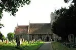 Parish Church of All Saints |
| Boundary Wall at Yewtree Farm | Hadham Cross, Much Hadham | Boundary Wall | Mid-late 19th century | 30 April 1985 | TL4266918553 51°50′50″N 0°04′11″E |
1289112 | |
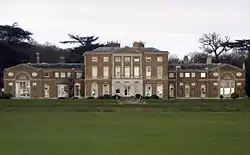
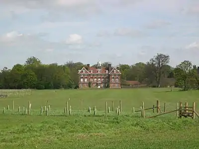
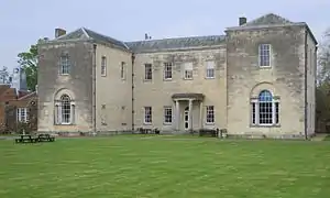
| Moor Place | Kettle Green, Much Hadham | Country House | 1775-9 | 22 February 1967 | TL4215318918 51°51′03″N 0°03′45″E |
1289132 | 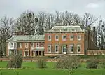 Moor Place |
| Much Hadham Hall | Much Hadham | Country House | 1726-9 | 22 February 1967 | TL4283219368 51°51′17″N 0°04′21″E |
1212633 | .jpg.webp) Much Hadham Hall |
| Parish Church of St Andrew | Much Hadham | Parish Church | 12th century | 22 February 1967 | TL4303319674 51°51′26″N 0°04′32″E |
1289691 | 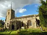 Parish Church of St Andrew |
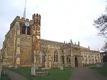
| Parish Church of Great St Mary's | Sawbridgeworth | Anglican Church | 13th century | 6 June 1952 | TL4850014822 51°48′44″N 0°09′10″E |
1101668 |  Parish Church of Great St Mary's |
| Church of St Mary | Standon | Church | 15th century | 24 January 1967 | TL3964922257 51°52′53″N 0°01′39″E |
1102348 |  Church of St Mary |
| Old Church of St James | Stanstead Abbotts | Church | 12th century | 24 January 1967 | TL3997211061 51°46′51″N 0°01′40″E |
1078730 | |
| Rye House Gatehouse | Lea Valley Park, Stanstead Abbotts | Moat | 15th century | 4 December 1951 | TL3857309955 51°46′16″N 0°00′25″E |
1341877 | |
| Church of St Peter | Tewin | Church | 11th century | 24 November 1966 | TL2681214256 51°48′45″N 0°09′43″W |
1341477 | 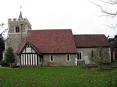 Church of St Peter |
| Parish Church of St James the Great | Thorley | Moat | 1834 | 22 February 1967 | TL4760418844 51°50′55″N 0°08′29″E |
1213947 | 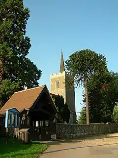 Parish Church of St James the Great |
| Parish Church of St Mary the Virgin | Walkern | Parish Church | Saxon | 24 November 1966 | TL2928626565 51°55′21″N 0°07′17″W |
1101384 | 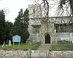 Parish Church of St Mary the Virgin |
| Church of St Mary | Ware | Church | 1982 | 8 May 1950 | TL3568014430 51°48′43″N 0°02′00″W |
1217410 |  Church of St Mary |
| Grotto between Nos 28 and 34 (Scott's Grotto) | Ware | Grotto | 1764-1768 | 8 May 1950 | TL3568813832 51°48′24″N 0°02′00″W |
1238171 | .jpg.webp) Grotto between Nos 28 and 34 (Scott's Grotto) |
| Place House | Ware | House | 17th century | 8 May 1950 | TL3590314372 51°48′41″N 0°01′48″W |
1275417 | .jpg.webp) Place House |
| The Priory (Ware Town Council Offices and Community Centre) | Ware | Kitchen | 1993-4 | 8 May 1950 | TL3555114312 51°48′40″N 0°02′06″W |
1237950 | 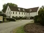 The Priory (Ware Town Council Offices and Community Centre) |
| Woodhall Park (Heath Mount School) | Woodhall Park, Watton-at-Stone | Country House | 1777-82 | 20 October 1952 | TL3164518896 51°51′11″N 0°05′24″W |
1031363 | |
| Church of St Giles | Wyddial | Parish Church | 14th century | 22 February 1967 | TL3741431763 51°58′03″N 0°00′04″W |
1101811 | 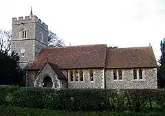 Church of St Giles |


.jpg.webp)
Hertsmere
| Name | Location | Type | Completed [note 1] | Date designated | Grid ref.[note 2] Geo-coordinates |
Entry number [note 3] | Image |
|---|---|---|---|---|---|---|---|
| Church of St John the Baptist | Aldenham | Parish Church | 12th century | 1 September 1953 | TQ1398898463 51°40′24″N 0°21′11″W |
1103642 | 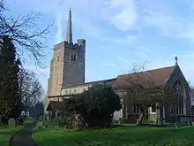 Church of St John the Baptist |
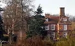
| Tyttenhanger House | Ridge | Country House | c. 1655 | 25 February 1952 | TL1914604655 51°43′41″N 0°16′35″W |
1174935 | |
| Church of St Giles | South Mimms | Parish Church | 13th century | 20 May 1949 | TL2223101196 51°41′46″N 0°13′58″W |
1174342 | 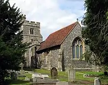 Church of St Giles |
North Hertfordshire
| Name | Location | Type | Completed [note 1] | Date designated | Grid ref.[note 2] Geo-coordinates |
Entry number [note 3] | Image |
|---|---|---|---|---|---|---|---|
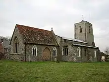
| Church of St Mary the Virgin | Ashwell | Parish Church | 14th century | 27 May 1968 | TL2671039779 52°02′31″N 0°09′14″W |
1102715 | |
| Church of St Mary Magdalene | Barkway | Parish Church | 13th century | 27 May 1968 | TL3828035610 52°00′06″N 0°00′47″E |
1102624 | 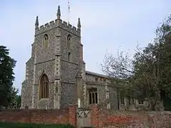 Church of St Mary Magdalene |
| Church of St Mary | Graveley | Parish Church | 12th century | 27 May 1968 | TL2348928125 51°56′17″N 0°12′18″W |
1102525 | 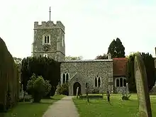 Church of St Mary |
| Church of St Katherine of Alexandria | Ickleford | Parish Church | Mid 12th century | 27 May 1968 | TL1824031641 51°58′14″N 0°16′49″W |
1295821 | |
| Parish Church of St Peter and St Paul | Kimpton | Parish Church | c. 1200 | 27 May 1968 | TL1775818526 51°51′10″N 0°17′30″W |
1102783 | 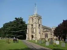 Parish Church of St Peter and St Paul |
| Church of St Mary | King's Walden | Parish Church | 12th century to 13th century | 27 May 1968 | TL1602323507 51°53′53″N 0°18′55″W |
1102475 | 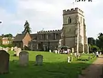 Church of St Mary |
| Church of St Mary and St Thomas | Old Knebworth | Parish Church | c. 1150 | 27 May 1968 | TL2308521007 51°52′27″N 0°12′49″W |
1295771 | |
| Church of St Mary Magdalene | Great Offley | Parish Church | Early 13th century | 27 May 1968 | TL1453326816 51°55′41″N 0°20′09″W |
1347084 | 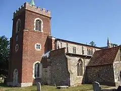 Church of St Mary Magdalene |
| Church of St Mary | Pirton | Motte and Bailey | Early 12th century | 27 May 1968 | TL1469431661 51°58′18″N 0°19′54″W |
1347110 | 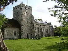 Church of St Mary |
| High Down House with Buildings and Walls around Courtyard on North Side | Pirton | Courtyard House | 1599 | 9 June 1952 | TL1439530544 51°57′42″N 0°20′11″W |
1175442 |  High Down House with Buildings and Walls around Courtyard on North Side |
| Church of St Mary | Reed | Parish Church | Early 11th century | 27 May 1968 | TL3613235748 52°00′13″N 0°01′06″W |
1102559 |  Church of St Mary |
| Church of St John the Baptist | Royston | Church | Second Half 12th century | 14 June 1964 | TL3576240678 52°02′52″N 0°01′18″W |
1295575 | |
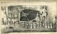
| Royston Cave | Royston | Cave | 13th century OR 14th century | 14 June 1976 | TL3562940711 52°02′54″N 0°01′25″W |
1102013 | |
| 18 Melbourn Street | Royston | House | 18th century | 14 June 1964 | TL3576340737 52°02′54″N 0°01′18″W |
1174750 | .jpg.webp) 18 Melbourn Street |
| 23 Kneesworth Street | Royston | House | c.1700 remodelling of earlier house | 14 June 1964 | TL3556640818 52°02′57″N 0°01′28″W |
1295658 | 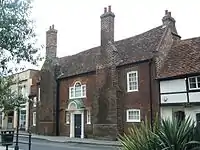 23 Kneesworth Street |
| Church of All Saints | Sandon | Parish Church | 1348 | 27 May 1968 | TL3223734526 51°59′36″N 0°04′32″W |
1176178 | |
| Almshoe Bury | St Ippolyts | Farmhouse | c. 1374 | 27 May 1968 | TL2067125286 51°54′47″N 0°14′49″W |
1102513 | |
| Church of St Ippolyts | St Ippolyts | Parish Church | 11th century | 27 May 1968 | TL1979227127 51°55′47″N 0°15′33″W |
1347411 |  Church of St Ippolyts |
| Church of All Saints | St Paul's Walden | Parish Church | 12th century or 13th century | 27 May 1968 | TL1925022284 51°53′11″N 0°16′07″W |
1347042 | 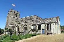 Church of All Saints |
| Church of the Holy Trinity | Church End, Weston | Parish Church | 12th century | 27 May 1968 | TL2658829952 51°57′13″N 0°09′34″W |
1347414 | |
| Church of St Mary the Virgin | Great Wymondley | Parish Church | 12th century | 27 May 1968 | TL2147528530 51°56′31″N 0°14′03″W |
1102497 | 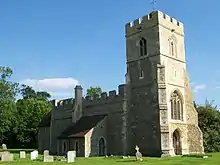 Church of St Mary the Virgin |
| The Priory | Little Wymondley | House | c1536 after 1536 | 27 May 1968 | TL2186327974 51°56′13″N 0°13′44″W |
1102499 | |
| Wymondley Bury | Little Wymondley | Farmhouse | 16th century | 27 May 1968 | TL2167827074 51°55′44″N 0°13′54″W |
1347446 | |
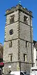
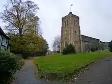
| Church of Saint Mary | Hitchin | Parish Church | 12th century | 13 April 1951 | TL1849829120 51°56′53″N 0°16′38″W |
1296273 | |
| Church of St. Mary the Virgin | Baldock | Church | 14th century | 8 November 1949 | TL2439633905 51°59′23″N 0°11′23″W |
1347611 | |
| The Priory | Hitchin | Country House | 17th century | 13 April 1951 | TL1838328793 51°56′42″N 0°16′45″W |
1102211 |


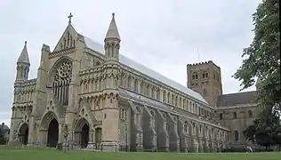
St Albans

Stevenage
| Name | Location | Type | Completed [note 1] | Date designated | Grid ref.[note 2] Geo-coordinates |
Entry number [note 3] | Image |
|---|---|---|---|---|---|---|---|
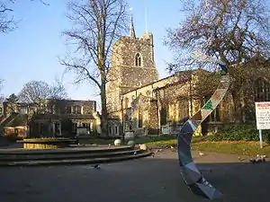
| Church of Saint Nicholas | Stevenage | Church | c. 1125 | 18 February 1948 | TL2407426207 51°55′14″N 0°11′50″W |
1176923 | |
| Rooks Nest House (Howards) | Stevenage | House | 18th century | 30 September 1976 | TL2443826721 51°55′30″N 0°11′30″W |
1176972 | 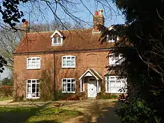 Rooks Nest House (Howards) |

Three Rivers
| Name | Location | Type | Completed [note 1] | Date designated | Grid ref.[note 2] Geo-coordinates |
Entry number [note 3] | Image |
|---|---|---|---|---|---|---|---|
| Church of St Lawrence the Martyr | Abbots Langley | Parish Church | Late 12th century | 1 September 1953 | TL0948202189 51°42′28″N 0°25′01″W |
1296433 |  Church of St Lawrence the Martyr |
| The Orchard | Chorleywood | House | 1899-1900 | 16 July 1975 | TQ0193295698 51°39′03″N 0°31′41″W |
1348234 | |
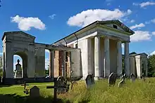
| Moor Park and Orangery/Stable Block | Rickmansworth | Country House | Late 17th century | 26 July 1951 | TQ0745893316 51°37′42″N 0°26′56″W |
1173698 | 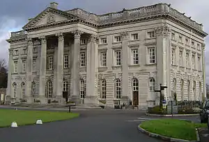 Moor Park and Orangery/Stable Block |
Watford
| Name | Location | Type | Completed [note 1] | Date designated | Grid ref.[note 2] Geo-coordinates |
Entry number [note 3] | Image |
|---|---|---|---|---|---|---|---|
| Church of St Mary | Watford | Church | 13th century | 26 August 1952 | TQ1107696316 51°39′17″N 0°23′45″W |
1101120 | |
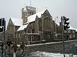
| Holy Rood Church | Watford | Roman Catholic Church | 1879-1900 | 12 September 1980 | TQ1087796327 51°39′17″N 0°23′55″W |
1101104 |
Welwyn Hatfield
| Name | Location | Type | Completed [note 1] | Date designated | Grid ref.[note 2] Geo-coordinates |
Entry number [note 3] | Image |
|---|---|---|---|---|---|---|---|
| New Saint Lawrence Church | Ayot St. Lawrence | Church | 1778 | 24 January 1967 | TL1917116895 51°50′17″N 0°16′18″W |
1348106 | |
| Brocket Hall | Lemsford | Country House | c. 1760 | 6 February 1952 | TL2140813036 51°48′10″N 0°14′26″W |
1100987 | |
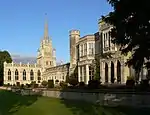
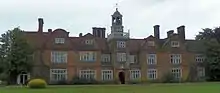
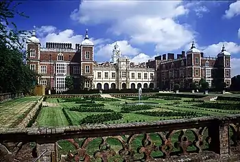
| Hatfield House | Old Hatfield, Hatfield | Country House | 1607-1612 | 6 February 1952 | TL2371508394 51°45′38″N 0°12′32″W |
1173363 | |
| Parish Church of St Etheldreda | Hatfield | Church | 13th century | 30 March 1966 | TL2350508488 51°45′41″N 0°12′43″W |
1348124 | |
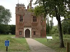
| The Palace | Old Hatfield, Hatfield | Bishops Palace | c. 1480 | 6 February 1952 | TL2357808460 51°45′40″N 0°12′39″W |
1348152 | 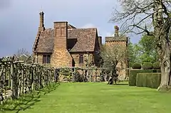 The Palace |
| North Mymms Park with Adjoining Garden Walls and Ha Ha | North Mymms | Country House | c. 1600 | 6 February 1952 | TL2177604267 51°43′26″N 0°14′18″W |
1100946 |  North Mymms Park with Adjoining Garden Walls and Ha Ha |

Notes
- The date given is the date used by Historic England as significant for the initial building or that of an important part in the structure's description.
- Sometimes known as OSGB36, the grid reference is based on the British national grid reference system used by the Ordnance Survey.
- The "List Entry Number" is a unique number assigned to each listed building and scheduled monument by Historic England.
External links
![]() Media related to Grade I listed buildings in Hertfordshire at Wikimedia Commons
Media related to Grade I listed buildings in Hertfordshire at Wikimedia Commons
This article is issued from Wikipedia. The text is licensed under Creative Commons - Attribution - Sharealike. Additional terms may apply for the media files.