Grade I listed buildings in Cheshire East
There are over 9,000 Grade I listed buildings in England. This page is a list of these buildings in the unitary authority of Cheshire East.
Listed buildings
| Name | Location | Type | Completed [note 1] | Date designated | Grid ref.[note 2] Geo-coordinates | Notes | Entry number [note 3] | Image |
|---|---|---|---|---|---|---|---|---|
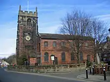
| Church of St Mary the Virgin | Acton | Parish church | 13th century | 12 January 1967 | SJ6317353088 53°04′24″N 2°32′59″W | 1330112 | ||
| Dorfold Hall | Dorfold Park, Acton | Country house | 1616 | 10 June 1952 | SJ6357052508 53°04′06″N 2°32′37″W | 1312869 | ||
| Adlington Hall | Adlington | Moat | 1505 | 25 July 1952 | SJ9046280471 53°19′15″N 2°08′36″W | 1234130 | ||
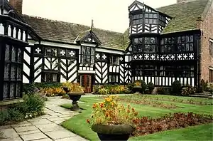
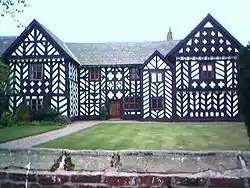
| Chorley Old Hall | Alderley Edge | Cruck house | c.1330 | 10 September 1959 | SJ8375078129 53°17′59″N 2°14′38″W | 1234539 | ||
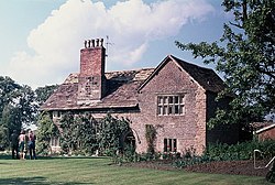
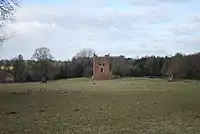
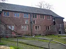
| Cruck barn approximately 100 yards to west of Arley Hall | Arley Hall, Aston By Budworth | Barn | Early 16th century | 5 March 1959 | SJ6745380896 53°19′25″N 2°29′19″W | 1329696 | 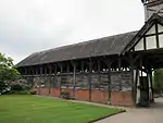 Cruck barn approximately 100 yards to west of Arley Hall | |
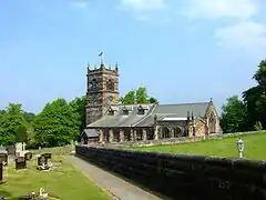
| Church of St James | Audlem | Church | Late 13th century | 12 January 1967 | SJ6600443655 52°59′20″N 2°30′23″W | 1136872 | ||
| Moss Hall | Audlem | Manor house | Early 17th century | 10 June 1952 | SJ6554944060 52°59′33″N 2°30′48″W | 1138519 | ||
| Church of St Michael | Baddiley | Parish church | 1308 | 12 January 1967 | SJ6051250344 53°02′55″N 2°35′21″W | 1138586 | ||
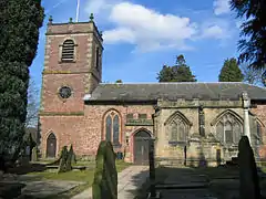
| The Church of St Bertoline | Barthomley | Parish church | 12th century | 12 January 1967 | SJ7676152378 53°04′04″N 2°20′49″W | 1330063 | ||
| Brereton Hall | Brereton Green, Brereton | Country house | 1585 | 6 June 1952 | SJ7812664855 53°10′48″N 2°19′38″W | 1229329 | ||
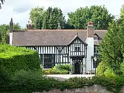
| Highfields | Buerton | Country house | 1615 | 10 June 1952 | SJ6749040988 52°57′54″N 2°29′03″W | 1330162 | ||
| The Church of St Boniface | Bunbury | Parish church | 14th century | 12 January 1967 | SJ5691258087 53°07′05″N 2°38′38″W | 1138626 | ||
| The Chapel of Saint Nicholas | Cholmondeley Park, Cholmondeley | Chapel | Late 15th century | 12 January 1967 | SJ5446451638 53°03′35″N 2°40′46″W | 1138593 | ||
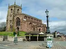
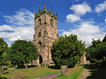
| Church of St Peter | Congleton | Parish church | 1740–42 | 28 July 1950 | SJ8595462760 53°09′41″N 2°12′36″W | 1330322 | ||
| Crewe Hall | Crewe Hall Park, Crewe Green | Country house | 1615–36 | 20 January 1975 | SJ7330454021 53°04′57″N 2°23′55″W | 1138666 | ||
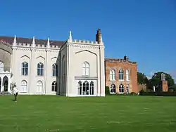
| Combermere Abbey | Combermere Park, Dodcott cum Wilkesley | Country house | Early 16th century | 10 June 1952 | SJ5872844122 52°59′33″N 2°36′54″W | Combermere Abbey incorporates the remains of a Cistercian monastery, founded in 1133. The monastic core is believed to represent the Abbot's House, a timber-framed building with a hammerbeam roof whose timbers have been dated to 1502; the building is thought to have been remodelled not long before the abbey's dissolution in 1538. It became the country house of the Cotton family, who redesigned it in 1563. The building was remodelled and extended in the 1790s, and further extended and Gothicised in around 1814–21, with the addition of cement render, castellations and windows with pointed arches. Parts of the later additions were removed or reduced in the 1970s.[1][2][3] | 1136900 | |
| Delves Hall | Doddington Park, Doddington | House | Early/mid-17th century | 12 January 1967 | SJ7087347025 53°01′10″N 2°26′03″W | 1330165 | ||
| Doddington Hall | Doddington Park, Doddington | Country house | 1777–90 | 10 June 1952 | SJ7093946474 53°00′52″N 2°26′00″W | 1136840 | ||
| Woodhey Chapel | Woodhey, Faddiley | Loggia | Early 17th century | 12 January 1967 | SJ5732452792 53°04′13″N 2°38′13″W | 1312896 | ||
| Church of St James | Gawsworth | Church | 15th century | 14 April 1967 | SJ8901069688 53°13′26″N 2°09′53″W | 1139497 | ||
| Gawsworth Old Hall | Gawsworth | Country house | 15th century | 25 July 1952 | SJ8916369647 53°13′25″N 2°09′44″W | 1139500 | ||
| The Old Rectory | Gawsworth | House | Late 16th century | 25 July 1952 | SJ8897769777 53°13′29″N 2°09′54″W | 1139496 | ||
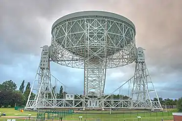
| Sir Bernard Lovell Telescope, Jodrell Bank Laboratory | Jodrell Bank, Goostrey | Radio telescope | 1952–57 | 13 July 1988 | SJ7950071099 53°14′10″N 2°18′26″W | This telescope is situated within the wider Jodrell Bank Observatory, Cheshire's only UNESCO World Heritage Site - designated in July 2019.[4][5] | 1221685 | |
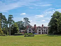
| Haslington Hall | Haslington | Country house | Late 15th century | 10 June 1952 | SJ7483655933 53°05′59″N 2°22′33″W | 1136283 | ||
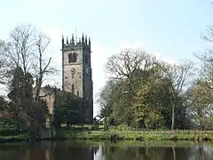
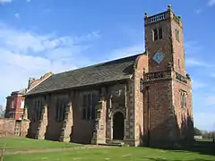
| Church of St Luke | Holmes Chapel | Parish church | c.1430 | 14 February 1967 | SJ7621867274 53°12′06″N 2°21′22″W | 1231322 | ||
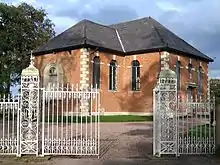
| Brook Street Chapel | Knutsford | Unitarian chapel | 1689 | 18 January 1949 | SJ7542978361 53°18′06″N 2°22′12″W | This is a brick building with a stone-slate roof, expressed externally in two storeys, but interiorly is a single cell. The chapel was attended by Mrs Gaskell, who is buried in the churchyard. It is in use as a Unitarian chapel.[6][7] | 1388306 | |
| Lyme Park | Lyme Park Country Park, Lyme Handley | Country house | c.1570 | 17 November 1983 | SJ9646782358 53°20′16″N 2°03′11″W | 1231685 | ||
| Church of St James and St Paul | Marton | Church | c.1370 | 14 April 1967 | SJ8502267993 53°12′31″N 2°13′27″W | 1139465 | ||
| Church of St Wilfrid | Mobberley | Church | 14th–15th century | 5 March 1959 | SJ7903580185 53°19′04″N 2°18′53″W | 1139554 | ||
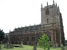
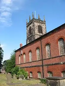
| St Mary's Church | Nantwich | Parish church | 14th century | 19 April 1948 | SJ6521052324 53°04′01″N 2°31′14″W | St Mary's is a large cruciform parish church in sandstone, sometimes referred to as the "cathedral of South Cheshire". Mainly in decorated style with later perpendicular additions, it was restored in 1854–61 by George Gilbert Scott. The exterior has an octagonal tower; the interior has an unusual stone lierne-vault above the chancel, carved oak canopied choir stalls (late 14th century), a perpendicular stone pulpit and a later wooden example (1601). The church was used as a prison during the Civil War.[8][9][10] | 1206059 | |
| Churche's Mansion | Hospital Street, Nantwich | House | 1577 | 19 April 1948 | SJ6562752150 53°03′56″N 2°30′52″W | Churche's Mansion is a timber-framed, four-gabled black-and-white mansion house by Thomas Clease. The two storeys and attics all have overhangs; the corbels in the eaves are decorated with carvings of animals. The upper storeys have decorative panels. Originally the residence of the Churche family, the mansion has housed a school and later a restaurant; it is now a shop.[11][12] | 1039605 | |
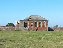
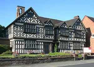
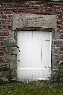
| Crown Inn, 24 & 26 High Street | Nantwich | Assembly rooms | c. 1584 | 19 April 1948 | SJ6507252357 53°04′02″N 2°31′22″W | The Crown Inn is a timber-framed, three-storey black-and-white inn rebuilt shortly after the 1583 fire, and formerly the principal inn of the town. The street-facing front is flat and features close studding with a middle rail, lacking ornamental panels. There are slight overhangs at each storey, with carved brackets. The second floor has unusual continuous windows along the front; it was originally a single gallery, which was partitioned in the 18th century. An 18th-century assembly room lies at the rear. It was used as a place of worship during the Civil War.[8][11][13][14] | 1330054 | 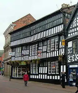 Crown Inn, 24 & 26 High Street |
| Church of St Mary | Nether Alderley | Church | 14th century | 14 April 1967 | SJ8417276133 53°16′54″N 2°14′15″W | 1138849 | ||
| Church of St Mary | Newbold Astbury | Church | 12th century | 14 February 1967 | SJ8462361527 53°09′01″N 2°13′48″W | 1138740 | ||
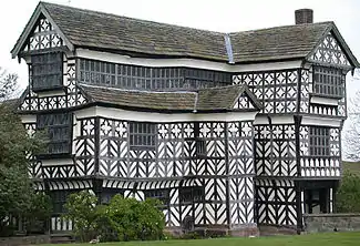
| Little Moreton Hall | Odd Rode | Country house | Early 15th century–c.1600 | 6 June 1952 | SJ8325158924 53°07′37″N 2°15′01″W | 1161988 | ||
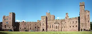
| Peckforton Castle | Peckforton | Castle | 1844–50 | 10 June 1952 | SJ5332658084 53°07′03″N 2°41′51″W | 1135729 | ||
| Church of St Lawrence | Peover Hall Park, Peover Superior | Church | 1456 | 5 March 1959 | SJ7720773517 53°15′28″N 2°20′30″W | 1139274 | ||
| The Old Stable Block, Peover Hall | Peover Hall Park, Peover Superior | Stable | 1654 | 5 September 1959 | SJ7733473400 53°15′25″N 2°20′23″W | 1335855 | ||
| Church of St Christopher | Pott Shrigley | Church | 15th century | 14 April 1967 | SJ9444879208 53°18′34″N 2°05′00″W | 1277234 | ||
| Church of St Peter | Prestbury | Church | Early–mid-13th century | 14 April 1967 | SJ9006476931 53°17′20″N 2°08′57″W | 1221919 | ||
| Church of St Mary | Rostherne | Church | 14th century | 5 March 1959 | SJ7426783691 53°20′57″N 2°23′12″W | 1230301 | ||
| Old Hall Hotel | Sandbach | House | 1656 | 11 August 1950 | SJ7596860668 53°08′32″N 2°21′34″W | 1310849 | ||
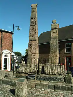
| Sandbach Crosses | Sandbach | Cross | Early–mid-9th century | 11 August 1950 | SJ7587760825 53°08′37″N 2°21′38″W | 1159937 | ||
| Church of St Peter (at Tabley House) | Tabley Inferior | Church | c.1714 | 5 March 1959 | SJ7249077766 53°17′45″N 2°24′46″W | 1329685 | ||
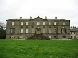
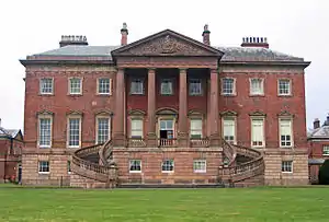
| Tabley House | Tabley Inferior | House | 1760–67 | 5 March 1959 | SJ7255977752 53°17′45″N 2°24′42″W | 1115424 | ||
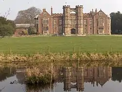
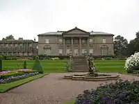
| Tatton Hall | Tatton Park, Tatton | Country house | 1780–91 | 5 March 1959 | SJ7449081566 53°19′48″N 2°22′59″W | 1329670 | ||
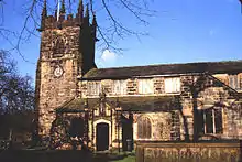
| Church of St Bartholomew | Wilmslow | Church | Decorated | 30 March 1951 | SJ8480381492 53°19′47″N 2°13′42″W | 1222475 | ||
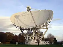
| Mark II (radio telescope) | Jodrell Bank Observatory | Radio telescope | 1964 | 10 July 2017 | SJ7981570810 53°14′02″N 2°18′14″W | 1443087 |


.jpg.webp)


Notes
- The date given is the date used by Historic England as significant for the initial building or that of an important part in the structure's description.
- Sometimes known as OSGB36, the grid reference is based on the British national grid reference system used by the Ordnance Survey.
- The "List Entry Number" is a unique number assigned to each listed building and scheduled monument by Historic England.
See also
References
- de Figueiredo & Treuherz, pp. 60–65
- Hartwell et al., pp. 293–95
- Historic England, "Combermere Abbey (1136900)", National Heritage List for England, retrieved 25 March 2015
- "Jodrell Bank Observatory". UNESCO. 7 July 2019.
- "Jodrell Bank gains Unesco World Heritage status". BBC News. Retrieved 7 July 2019.
- Hartwell et al. 2011, p. 421.
- Historic England, "Brook Street Unitarian Chapel, Knutsford (1388306)", National Heritage List for England, retrieved 26 April 2012
- Take a Closer Look at Nantwich (booklet), Crewe & Nantwich Borough Council
- Historic England, "Church of St Mary, Churchyard Side, Nantwich (1206059)", National Heritage List for England, retrieved 25 March 2015
- Pevsner & Hubbard, 1971, pp. 15, 18, 285–87
- Pevsner & Hubbard, 1971, pp. 287–89
- Historic England, "Churche's Mansion, Hospital Street (1039605)", National Heritage List for England, retrieved 25 March 2015
- Historic England, "High Street: No 24 (Crown Inn), No 26 (Coffee House Cafe) (1330054)", National Heritage List for England, retrieved 25 March 2015
- McKenna, 1994, p. 18
External links
This article is issued from Wikipedia. The text is licensed under Creative Commons - Attribution - Sharealike. Additional terms may apply for the media files.