Grade I listed buildings in Worcestershire
There are over 9000 Grade I listed buildings in England. This page is a list of these buildings in the county of Worcestershire, by district.
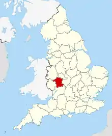
Worcestershire shown within England
Bromsgrove
| Name | Location | Type | Completed [note 1] | Date designated | Grid ref.[note 2] Geo-coordinates |
Entry number [note 3] | Image |
|---|---|---|---|---|---|---|---|
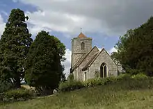
| Church of St Leonard | Beoley | Church | 12th century | 16 November 1967 | SP0652069648 52°19′30″N 1°54′21″W |
1167467 | 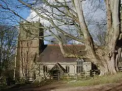 Church of St Leonard |
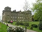
| Hagley Hall | Hagley Park, Hagley | Country House | 1754-60 | 23 April 1952 | SO9195980690 52°25′27″N 2°07′11″W |
1296865 | |
| Temple of Theseus about 1/2 mile north of Hagley Hall | Wychbury Hill, Hagley | Temple | 1758 | 23 April 1952 | SO9213281351 52°25′48″N 2°07′02″W |
1348599 | .jpg.webp) Temple of Theseus about 1/2 mile north of Hagley Hall |
| Church of St Kenelm | Romsley | Chapel of Ease | 12th century | 16 November 1967 | SO9444480755 52°25′29″N 2°04′59″W |
1100110 |  Church of St Kenelm |
| Church of St Michael | Stoke Prior | Parish Church | Early 12th century | 16 November 1967 | SO9493467699 52°18′27″N 2°04′33″W |
1100179 | .jpg.webp) Church of St Michael |
| Church of St John the Baptist | Bromsgrove | Church | 12th century | 28 April 1952 | SO9569770677 52°20′03″N 2°03′52″W |
1100363 | 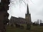 Church of St John the Baptist |
| Hewell Grange | Hewell Park, Tutnall and Cobley, Bromsgrove | Country House | 1884-1891 | 16 July 1986 | SP0067669010 52°19′09″N 1°59′29″W |
1100160 |
Malvern Hills
| Name | Location | Type | Completed [note 1] | Date designated | Grid ref.[note 2] Geo-coordinates |
Entry number [note 3] | Image |
|---|---|---|---|---|---|---|---|
| Church of St Peter | Astley | Parish Church | Mid-Late 12th century | 29 July 1959 | SO7876267619 52°18′23″N 2°18′46″W |
1082676 |  Church of St Peter |
| Birtsmorton Court | Birtsmorton | Moat | 14th century | 11 August 1952 | SO8006235447 52°01′02″N 2°17′31″W |
1098856 | |
| Church of St Gregory | Castlemorton | Church | Early 12th century | 25 March 1968 | SO7948937251 52°02′00″N 2°18′01″W |
1156879 | 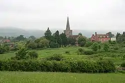 Church of St Gregory |
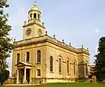
| Church of St Mary Magdalene | Croome D'abitot | Church | 1758 | 25 March 1968 | SO8864645034 52°06′13″N 2°10′02″W |
1082581 | |
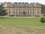
| Croome Court | Croome D'abitot | Country House | 1751-2 | 11 August 1952 | SO8849444596 52°05′58″N 2°10′10″W |
1349526 | |
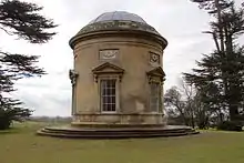
| Island Temple, Croome Park | Croome D'abitot | Garden Temple | c. 1800 | 25 March 1968 | SO8789944648 52°06′00″N 2°10′41″W |
1302560 | |
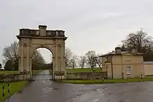
| Pershore (or London) Lodge and Gates | Croome D'abitot | Gate | c. 1760 | 11 August 1952 | SO8886344864 52°06′07″N 2°09′50″W |
1082579 | |
| Temple Greenhouse, Croome Park | Croome D'abitot | Temple | c. 1760 | 25 March 1968 | SO8814144996 52°06′11″N 2°10′28″W |
1082575 | |
| The Panorama | Croome D'abitot | Garden Temple | c. 1800 | 11 August 1952 | SO8643144502 52°05′55″N 2°11′58″W |
1082582 | 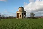 The Panorama |
| The Rotunda, the Shrubbery, Croome Park | Croome D'abitot | Garden Temple | c. 1760 | 11 August 1952 | SO8886244549 52°05′57″N 2°09′50″W |
1082574 | |
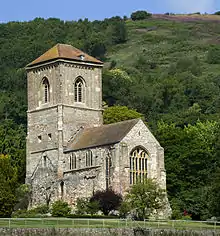
| Church of St Peter and St Paul | Eastham | Parish Church | 12th century | 18 April 1966 | SO6569768729 52°18′56″N 2°30′17″W |
1350032 | .jpg.webp) Church of St Peter and St Paul |
| Saint Michael and All Angels Church | Great Witley | Parish Church | 1735 | 29 July 1959 | SO7695364977 52°16′57″N 2°20′21″W |
1082655 | |
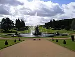
| Perseus and Andromeda Fountain | Witley Court, Great Witley | Statue | c. 1860 | 12 November 1951 | SO7695464826 52°16′52″N 2°20′21″W |
1349487 | |
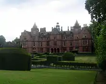
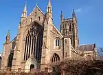
| Witley Court and Link to Church of St Michael | Witley Park, Great Witley | Country House | 17th century | 12 November 1951 | SO7698364937 52°16′56″N 2°20′20″W |
1082656 | 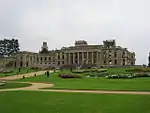 Witley Court and Link to Church of St Michael |
| Church of St Martin | Holt | Parish Church | Mid 12th century | 29 July 1959 | SO8295962556 52°15′39″N 2°15′04″W |
1349337 | 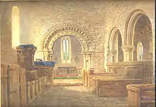 Church of St Martin |
| Holt Castle | Holt | Fortified House | 14th century | 12 November 1951 | SO8306162568 52°15′40″N 2°14′59″W |
1082922 | 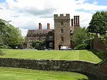 Holt Castle |
| Church of St Mary | Kempsey | Church | 12th century | 25 March 1968 | SO8482449061 52°08′23″N 2°13′23″W |
1157621 |  Church of St Mary |
| Church of St Michael | Knighton on Teme | Parish Church | 12th century | 18 April 1966 | SO6333669913 52°19′34″N 2°32′22″W |
1167609 | 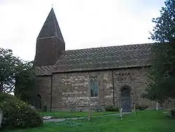 Church of St Michael |
| Church of St Eadburga | Leigh | Church | 12th century | 29 July 1959 | SO7842053456 52°10′44″N 2°19′01″W |
1098765 | 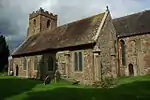 Church of St Eadburga |
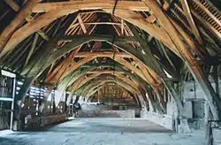
| Cruck Barn, Leigh Court | Leigh, Malvern Hills | Cruck Barn | 14th century | 9 February 1988 | SO7834753505 52°10′46″N 2°19′05″W |
1349245 | |
| Church of St Giles | Little Malvern | Church | Norman | 25 March 1968 | SO7703040381 52°03′41″N 2°20′11″W |
1349255 | |
| Eastington Hall and Barn to North West | Longdon | Jettied House | Late 13th century | 11 August 1952 | SO8308938154 52°02′29″N 2°14′53″W |
1238530 | 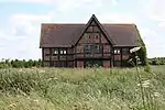 Eastington Hall and Barn to North West |
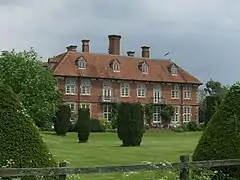
| Madresfield Court, Including Bridge, Retaining Wall and North Service Court | Madresfield | Country House | 16th century | 25 March 1968 | SO8087347463 52°07′31″N 2°16′51″W |
1098779 | 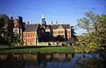 Madresfield Court, Including Bridge, Retaining Wall and North Service Court |
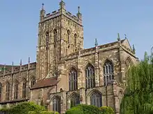
| Priory Church of St Mary and St Michael | Malvern | Church | c. 1085 | 30 November 1949 | SO7759545851 52°06′38″N 2°19′43″W |
1082794 | |
| Church of St John the Baptist | Mamble | Parish Church | c. 1200 | 18 April 1966 | SO6884471615 52°20′30″N 2°27′31″W |
1081406 |  Church of St John the Baptist |
| Church of St Peter | Martley | Parish Church | 12th century | 29 July 1959 | SO7563559814 52°14′10″N 2°21′30″W |
1082960 | .jpg.webp) Church of St Peter |
| The Old Hall | Martley | House | 14th century | 12 November 1951 | SO7569059872 52°14′11″N 2°21′27″W |
1349355 |  |
| Church of St Leonard | Newland | Church | 1862 | 25 March 1968 | SO7959348491 52°08′04″N 2°17′58″W |
1098739 |  Church of St Leonard |
| Pendock Church | Pendock | Church | Mid 12th century | 25 March 1968 | SO8170733704 52°00′05″N 2°16′04″W |
1098789 | |
| Church of St Peter and St Lawrence | Powick | Church | 12th century | 25 March 1968 | SO8344651525 52°09′42″N 2°14′36″W |
1166920 |  Church of St Peter and St Lawrence |
| Church of St Mary | Ripple | Church | Late 12th century to 13th century | 25 March 1968 | SO8761637737 52°02′16″N 2°10′55″W |
1349090 |  Church of St Mary |
| Church of St Andrew | Shelsley Walsh | Parish Church | 12th century | 29 July 1959 | SO7215862966 52°15′51″N 2°24′34″W |
1156637 | 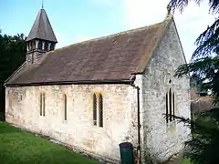 Church of St Andrew |
| Church of St Mary | Shrawley | Parish Church | Early-Mid 12th century | 27 November 1984 | SO8060464791 52°16′51″N 2°17′09″W |
1082650 | |
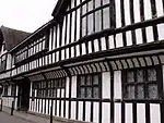
| The White House | Suckley | Farmhouse | Early 18th century | 12 November 1951 | SO7210452780 52°10′21″N 2°24′34″W |
1349724 | 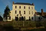 The White House |


.jpg.webp)
_-_geograph.org.uk_-_1457356.jpg.webp)
Redditch
| Name | Location | Type | Completed [note 1] | Date designated | Grid ref.[note 2] Geo-coordinates |
Entry number [note 3] | Image |
|---|---|---|---|---|---|---|---|
| Norgrove Court | Feckenham | Farmhouse | c. 1823 | 10 April 1954 | SP0071965377 52°17′12″N 1°59′27″W |
1167093 |
Worcester
| Name | Location | Type | Completed [note 1] | Date designated | Grid ref.[note 2] Geo-coordinates |
Entry number [note 3] | Image |
|---|---|---|---|---|---|---|---|
| Church of St Nicholas | Warndon, Worcester | Church | 12th century | 14 March 1969 | SO8878256887 52°12′36″N 2°09′56″W |
1301320 | 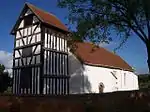 Church of St Nicholas |
| Berkeley's Hospital: Almshouses with Gate lodges, Piers and Gates | Worcester | Gate Lodge | 1672-1703 | 22 May 1954 | SO849551 52°11′38″N 2°13′19″W |
1390200 | 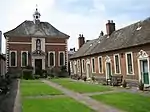 Berkeley's Hospital: Almshouses with Gate lodges, Piers and Gates |
| Berkeley's Hospital: Chapel | Worcester | Almshouse | 1703 | 22 May 1954 | SO8490255117 52°11′39″N 2°13′20″W |
1390199 |  Berkeley's Hospital: Chapel |
| Cathedral Church of Christ and St Mary | Worcester | Cathedral | 1084 | 22 May 1954 | SO8500254520 52°11′19″N 2°13′15″W |
1389728 | |
| Cathedral of St Mary: Cloister Range, Chapter House and Undercroft with Refectory | Worcester | Chapter House | c1100-1110 | 22 May 1954 | SO8499754484 52°11′18″N 2°13′15″W |
1389729 | |
| Church of St Swithun and Attached Railings | Worcester | Church | Made redundant | 22 May 1954 | SO8504354949 52°11′33″N 2°13′13″W |
1063801 | |
| Edgar Tower | Worcester | Gatehouse | Construction started c1300-35 | 22 May 1954 | SO8507554445 52°11′17″N 2°13′11″W |
1063829 | |
| Guildhall | Worcester | Assembly Rooms | c1721-3 | 22 May 1954 | SO8500354790 52°11′28″N 2°13′15″W |
1389921 | |
| King's School Hall (College Hall) |
Worcester | School | C20 | 22 May 1954 | SO8497854463 52°11′18″N 2°13′16″W |
1063830 | 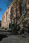 King's School Hall (College Hall) |
| Powick Old Bridge | Worcester | Bridge | Late Mediaeval | 25 March 1968 | SO8351152469 52°10′13″N 2°14′33″W |
1349275 | |
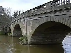
| Powick Old Bridge (that Part Within the City of Worcester) | Lower Wick, Worcester | Bridge | 16th century | 22 May 1954 | SO8352052490 52°10′14″N 2°14′33″W |
1390030 |  Powick Old Bridge (that Part Within the City of Worcester) |
| The Commandery | Worcester | House | 1540 | 22 May 1954 | SO8527654392 52°11′15″N 2°13′00″W |
1390176 | |
| The Greyfriars | Worcester | Apartment | 1870s | 22 May 1954 | SO8514654714 52°11′26″N 2°13′07″W |
1389859 | |
| The Old Palace | Worcester | Bishops Palace | c1200-1235 | 22 May 1954 | SO8491354629 52°11′23″N 2°13′20″W |
1389763 | |
| Wrought Iron Gates and Railings to Forecourt at Guildhall | Worcester | Gate | 1723 | 5 April 1971 | SO8501654793 52°11′28″N 2°13′14″W |
1389922 | .jpg.webp) Wrought Iron Gates and Railings to Forecourt at Guildhall |


Wychavon
| Name | Location | Type | Completed [note 1] | Date designated | Grid ref.[note 2] Geo-coordinates |
Entry number [note 3] | Image |
|---|---|---|---|---|---|---|---|
| Church of St Peter | Abbots Morton | Parish Church | 12th century | 30 July 1959 | SP0267454973 52°11′35″N 1°57′44″W |
1350229 | .jpg.webp) Church of St Peter |
| Church of St Mary | Aston Somerville | Church | 13th century | 29 July 1987 | SP0474237868 52°02′21″N 1°55′56″W |
1214230 | 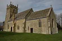 Church of St Mary |
| Church of St John the Baptist | Beckford | Parish Church | c. 1130 | 30 July 1959 | SO9761235841 52°01′16″N 2°02′10″W |
1167374 | 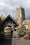 Church of St John the Baptist |
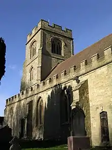
| Church of St Giles | Bredon | Church | Norman | 11 February 1965 | SO9200836978 52°01′52″N 2°07′04″W |
1117088 | 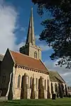 Church of St Giles |
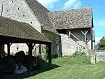
| Tithe Barn | Bredon | Tithe Barn | Late 14th century | 11 February 1965 | SO9184036954 52°01′51″N 2°07′13″W |
1319631 | |
| Church of St Leonard | Bretforton | Parish Church | Late 12th century | 30 July 1959 | SP0930143814 52°05′33″N 1°51′56″W |
1157784 | 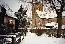 Church of St Leonard |
| Church of St Eadburgha | Broadway | Church | Late 12th century | 30 July 1959 | SP0970536258 52°01′29″N 1°51′36″W |
1287966 | 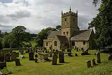 Church of St Eadburgha |
| Church of St Michael | Cropthorne | Cross | C9 | 11 February 1965 | SP0001645131 52°06′16″N 2°00′04″W |
1116923 |  Church of St Michael |
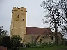
| Church of St Nicholas | Dormston | Bell Tower | Mid 15th century | 11 February 1965 | SO9872357574 52°12′59″N 2°01′12″W |
1116851 |  Church of St Nicholas |
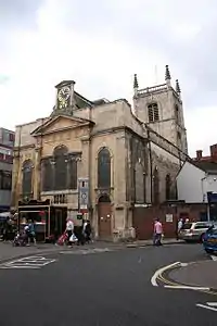
| Church of St Andrew | Droitwich Spa | Parish Church | C13-C14 | 24 October 1951 | SO8996063363 52°16′06″N 2°08′55″W |
1167974 | .jpg.webp) Church of St Andrew |
| Church of St Peter | Droitwich Spa | Parish Church | Norman | 24 October 1951 | SO9022562495 52°15′38″N 2°08′41″W |
1296639 | 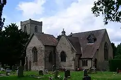 Church of St Peter |
| Church of St Mary | Elmley Castle | Church | Norman | 11 February 1965 | SO9819241008 52°04′03″N 2°01′40″W |
1116640 |  Church of St Mary |
| Abbot Reginald's Gateway | Evesham | Gate | c. 1120 | 7 May 1952 | SP0371143721 52°05′31″N 1°56′50″W |
1081349 |  Abbot Reginald's Gateway |
| Church of All Saints | Evesham | Church | Norman | 7 May 1952 | SP0373243699 52°05′30″N 1°56′49″W |
1081351 | 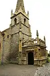 Church of All Saints |
| Gate and Railings of Number 53 | Evesham | Gate | Early 18th century | 24 June 1977 | SP0360143665 52°05′29″N 1°56′56″W |
1081359 | |
| Numbers 53 and 54 Incorporating Remains of Abbey Gate (Abbey Gate House) | Evesham | Abbey | Early 14th century | 7 May 1952 | SP0360443647 52°05′28″N 1°56′56″W |
1156720 | |
| Round House (National Westminster Bank) | Evesham | House | 1964-65 | 7 May 1952 | SP0372443791 52°05′33″N 1°56′49″W |
1156077 | .jpg.webp) Round House (National Westminster Bank) |
| The Almonry | Evesham | Abbey | 15th century or earlier | 7 May 1952 | SP0357143648 52°05′28″N 1°56′57″W |
1302722 | 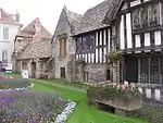 The Almonry |
| Evesham Abbey Bell Tower | Evesham | Bell Tower | Early 16th century | 7 May 1952 | SP0375043662 52°05′29″N 1°56′48″W |
1081353 | 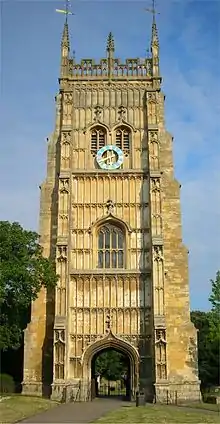 Evesham Abbey Bell Tower |
| Church of St John the Baptist | Fladbury | Parish Church | 12th century | 11 February 1965 | SO9962046276 52°06′53″N 2°00′25″W |
1039147 |  Church of St John the Baptist |
| Church of St Mary | Hampton Lovett | Parish Church | Early 12th century | 14 March 1969 | SO8890465595 52°17′18″N 2°09′51″W |
1215375 | 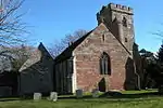 Church of St Mary |
| Church of St Mary the Virgin | Hanbury | Parish Church | 13th century | 14 March 1969 | SO9542564393 52°16′40″N 2°04′07″W |
1350133 | |
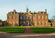
| Hanbury Hall | Hanbury | Country House | 1701 | 29 December 1952 | SO9441863741 52°16′18″N 2°05′00″W |
1350164 | |
| Mere Hall | Broughton Green, Hanbury | Country House | c. 1560 | 29 December 1952 | SO9520261847 52°15′17″N 2°04′18″W |
1301918 | 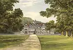 Mere Hall |
| Hartlebury Castle | Hartlebury | Bishops Palace | Mid 13th century | 29 December 1952 | SO8361171216 52°20′20″N 2°14′31″W |
1215570 | |
| Church of St James | Harvington | Parish Church | 12th century | 30 July 1959 | SP0571948827 52°08′16″N 1°55′04″W |
1350000 | 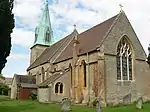 Church of St James |
| Church of St Mary Magdalene | Himbleton | Parish Church | 12th century | 14 March 1969 | SO9466358757 52°13′37″N 2°04′46″W |
1081205 | 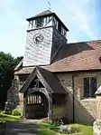 Church of St Mary Magdalene |
| Church of St Ecgwin | Honeybourne | Parish Church | 1295 | 30 July 1959 | SP1199544051 52°05′41″N 1°49′35″W |
1081550 |  Church of St Ecgwin |
| Church of St James | Huddington | Parish Church | 12th century | 14 March 1969 | SO9428757252 52°12′48″N 2°05′06″W |
1350155 | .jpg.webp) Church of St James |
| Huddington Court | Huddington | Moat | Early 16th century | 29 December 1952 | SO9424957294 52°12′50″N 2°05′08″W |
1081215 | |
| Church of St Peter | Inkberrow | Parish Church | 12th century | 30 July 1959 | SP0161357205 52°12′47″N 1°58′40″W |
1350279 |  Church of St Peter |
| The Tithe Barn | Middle Littleton, North and Middle Littleton | Farm Building | Early 14th century | 30 July 1959 | SP0798747069 52°07′19″N 1°53′05″W |
1350092 | |
| Ombersley Court | Ombersley | Country House | 1724-32 | 25 December 1952 | SO8418963389 52°16′06″N 2°13′59″W |
1172877 | 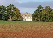 Ombersley Court |
| Church of St Faith | Overbury | Parish Church | 12th century | 30 July 1959 | SO9569837423 52°02′07″N 2°03′51″W |
1167601 | .jpg.webp) Church of St Faith |
| Church of St Peter | Pebworth | Church | 14th century | 30 July 1959 | SP1286046898 52°07′13″N 1°48′49″W |
1081297 |  Church of St Peter |
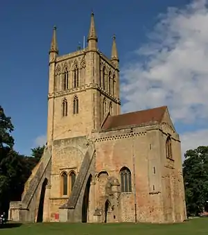
| Abbey Church of Holy Cross with Saint Edburgha | Pershore | Abbey | C11-C13 | 11 February 1965 | SO9478545789 52°06′37″N 2°04′39″W |
1387027 | |
| Perrott House | Pershore | House | c. 1760 | 11 February 1965 | SO9504645658 52°06′33″N 2°04′26″W |
1386920 | 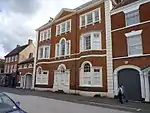 Perrott House |
| Church of St Peter | Pirton | Parish Church | 12th century | 11 February 1965 | SO8854346831 52°07′11″N 2°10′07″W |
1258259 |  Church of St Peter |
| Church of St Peter | Rous Lench | Parish Church | 12th century | 30 July 1959 | SP0146953286 52°10′40″N 1°58′48″W |
1081652 |  Church of St Peter |
| Church of St John the Baptist | Strensham | Parish Church | 14th century | 11 February 1965 | SO9108140629 52°03′50″N 2°07′53″W |
1273274 | |
| Falcon Tower About 35 Yards North West of Westwood House | Westwood Park, Westwood | Tower | Mid C20 | 14 March 1969 | SO8761063989 52°16′26″N 2°10′59″W |
1296011 | |
| Heron's Tower About 35 Yards South-east of Westwood House | Westwood Park, Westwood | Tower | Mid C20 | 14 March 1969 | SO8758163913 52°16′24″N 2°11′00″W |
1173901 | |
| Nos 1 and 2 the Gatehouse About 50 Yards East of Westwood House | Westwood Park, Westwood | House | 1660-70 | 14 March 1969 | SO8762163940 52°16′24″N 2°10′58″W |
1350205 | |
| Westwood House | Westwood Park, Westwood | Apartment | Mid C20 | 29 December 1952 | SO8756063967 52°16′25″N 2°11′01″W |
1173950 | |
| Church of St John the Baptist | Wickhamford | Church | 13th century | 30 July 1959 | SP0680842262 52°04′43″N 1°54′07″W |
1287774 | .jpg.webp) Church of St John the Baptist |


Wyre Forest
| Name | Location | Type | Completed [note 1] | Date designated | Grid ref.[note 2] Geo-coordinates |
Entry number [note 3] | Image |
|---|---|---|---|---|---|---|---|
| Severn Bridge Including Flanking Arches and Balustrade | Bewdley | Bridge | 1798 | 22 April 1950 | SO7873875444 52°22′36″N 2°18′50″W |
1100000 | |
| Church of St Cassian | Chaddesley Corbett | Parish Church | 12th century | 25 February 1958 | SO8913073595 52°21′37″N 2°09′40″W |
1100682 |  Church of St Cassian |
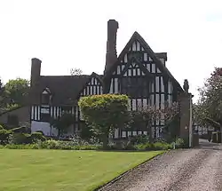
| Harvington Hall and Attached East Bridge | Harvington, Chaddesley Corbett | Country House | Late C16/Early 17th century | 25 February 1958 | SO8775374435 52°22′04″N 2°10′53″W |
1348331 | 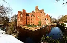 Harvington Hall and Attached East Bridge |
| Church of St Leonard | Ribbesford | Church | Early 12th century | 25 February 1958 | SO7863274019 52°21′50″N 2°18′55″W |
1115135 | 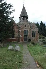 Church of St Leonard |
| Church of Saint Peter and Saint Paul | Rock | Church | Late 12th century | 25 February 1958 | SO7315471159 52°20′16″N 2°23′44″W |
1100696 | |
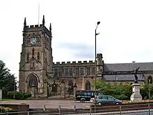
| The Parish Church of St Mary and All Saints | Kidderminster | Parish Church | 1315 | 20 October 1952 | SO8301576947 52°23′25″N 2°15′04″W |
1100050 |
See also
Category:Grade I listed buildings in Worcestershire
Notes
- The date given is the date used by Historic England as significant for the initial building or that of an important part in the structure's description.
- Sometimes known as OSGB36, the grid reference is based on the British national grid reference system used by the Ordnance Survey.
- The "List Entry Number" is a unique number assigned to each listed building and scheduled monument by Historic England.
References
External links
![]() Media related to Grade I listed buildings in Worcestershire at Wikimedia Commons
Media related to Grade I listed buildings in Worcestershire at Wikimedia Commons
This article is issued from Wikipedia. The text is licensed under Creative Commons - Attribution - Sharealike. Additional terms may apply for the media files.