Grade I listed buildings in Tonbridge and Malling
There are over 9,000 Grade I listed buildings in England. This page is a list of these buildings in the district of Ashford in Kent.
Tonbridge and Malling
| Name | Location | Type | Completed [note 1] | Date designated | Grid ref.[note 2] Geo-coordinates |
Entry number [note 3] | Image |
|---|---|---|---|---|---|---|---|
| Church of St Margaret | Addington, Tonbridge and Malling | Church | c. 1100 | 25 August 1959 | TQ6538558879 51°18′18″N 0°22′16″E |
1070567 | .jpg.webp) Church of St Margaret |
| Aylesford Bridge | Aylesford | Bridge | 14th century | 25 August 1959 | TQ7294158927 51°18′11″N 0°28′46″E |
1363113 | 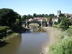 Aylesford Bridge |
| Church of St Peter | Aylesford | Church | 12th century | 25 August 1959 | TQ7293959032 51°18′15″N 0°28′46″E |
1337029 |  Church of St Peter |
| Gatehouse and Walls to the North and East of the Friars | Aylesford | Wall | 15th century | 25 February 1987 | TQ7240358930 51°18′12″N 0°28′19″E |
1111775 | 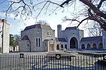 Gatehouse and Walls to the North and East of the Friars |
| The Friars, Main Block | Aylesford | Manor House | 15th century | 25 August 1959 | TQ7239658860 51°18′10″N 0°28′18″E |
1070570 |  The Friars, Main Block |
| Church of All Saints | Birling | Manor House | Early 14th century | 25 August 1959 | TQ6801960604 51°19′11″N 0°24′35″E |
1070519 | .jpg.webp) Church of All Saints |
| Church of St Mary the Virgin | Burham | Church | C12-C15 | 25 August 1959 | TQ7166062008 51°19′53″N 0°27′46″E |
1070523 | |
| Bradbourne House | East Malling and Larkfield | Manor House | 17th century | 1 August 1952 | TQ7036257909 51°17′41″N 0°26′31″E |
1070507 | |
| Church of St James | East Malling and Larkfield | Church | 12th century | 25 August 1959 | TQ7029457080 51°17′15″N 0°26′27″E |
1099148 | .JPG.webp) Church of St James |
| Clare House | East Malling and Larkfield | House | 1793 | 1 August 1952 | TQ6947357736 51°17′37″N 0°25′45″E |
1099100 |  |
| Stable Block and Barns 40 Yards North of Bradbourne House | East Malling and Larkfield | Barn | 19th century | 1 August 1952 | TQ7034157965 51°17′43″N 0°26′31″E |
1348523 | |
| Barnes Place | Golden Green, Hadlow | Kitchen | 18th century OR 19th century | 20 October 1954 | TQ6459248116 51°12′31″N 0°21′18″E |
1363161 | |
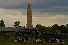
| Hadlow Castle | Hadlow | House | 1951 | 17 April 1951 | TQ6341949639 51°13′21″N 0°20′20″E |
1070451 | |
| Church of St Peter | Ightham | Church | c. 1400 | 25 August 1959 | TQ5948456930 51°17′21″N 0°17′09″E |
1071962 |  Church of St Peter |
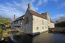
| Ightham Mote | Ightham | House | At least 1340-1360 | 1 August 1952 | TQ5847653485 51°15′31″N 0°16′11″E |
1362410 | |
| Church of St Lawrence | Mereworth | Parish Church | 1744-1746 | 25 August 1959 | TQ6601853752 51°15′32″N 0°22′40″E |
1186214 | |
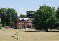
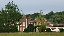
| Mereworth Castle (main Block) | Mereworth | House | 18th century | 1 August 1952 | TQ6689553230 51°15′14″N 0°23′25″E |
1070675 | 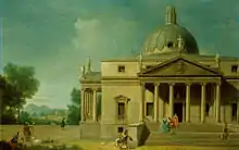 Mereworth Castle (main Block) |
| Pavilion to the North East of Mereworth Castle | Mereworth | Pavilion | Circa 1740-1750 | 1 August 1952 | TQ6694253276 51°15′15″N 0°23′27″E |
1363025 | _p2.104_-_Mereworth_Castle%252C_Kent.jpg.webp) Pavilion to the North East of Mereworth Castle |
| Pavilion to the North West and Stables of Mereworth Castle | Mereworth | Manor House | 1740-1750 | 1 August 1952 | TQ6686253285 51°15′16″N 0°23′23″E |
1070676 | Pavilion to the North West and Stables of Mereworth Castle |
| Yotes Court | Mereworth | Country House | 1656-1658 | 19 April 1985 | TQ6501553307 51°15′18″N 0°21′48″E |
1363026 |  Yotes Court |
| Church of St Michael | Offham | Church | c. 1100 | 25 August 1959 | TQ6602958063 51°17′51″N 0°22′48″E |
1264787 |  Church of St Michael |
| Fairlawne | Plaxtol | Country House | Before 1840 | 1 August 1952 | TQ5943653430 51°15′28″N 0°17′01″E |
1072711 | |
| Old Soar Manor | Plaxtol | Farmhouse | 18th century | 3 May 1984 | TQ6195054103 51°15′47″N 0°19′11″E |
1281122 | |
| Church of All Saints | Snodland | Parish Church | 12th century | 25 August 1959 | TQ7076161822 51°19′47″N 0°26′59″E |
1347897 |  Church of All Saints |
| Church of St Peter and St Paul | Trottiscliffe | Church | c. 1200 | 25 August 1959 | TQ6463460544 51°19′13″N 0°21′40″E |
1236191 |  Church of St Peter and St Paul |
| Gatehouse and Chapel to St Mary's Abbey | West Malling, Tonbridge and Malling | Abbey | Late 15th century or early 16th century | 25 August 1959 | TQ6822257740 51°17′38″N 0°24′41″E |
1209130 |  Gatehouse and Chapel to St Mary's Abbey |
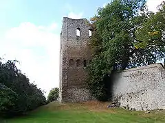
| St Leonard's Tower | West Malling | Bishops Palace | 1077-1108 | 30 November 1993 | TQ6759157081 51°17′18″N 0°24′07″E |
1219087 | |
| St Mary's Abbey Chapterhouse and Library | West Malling | Abbey | Norman | 25 August 1959 | TQ6829157677 51°17′36″N 0°24′44″E |
1291520 | |
| St Marys Abbey Convent Building | West Malling | Abbey | 1735 | 25 August 1959 | TQ6827157667 51°17′36″N 0°24′43″E |
1209132 | |
| St Mary's Abbey North Wall of Cloister | West Malling | Abbey | c. 1090 | 25 August 1959 | TQ6827557692 51°17′37″N 0°24′43″E |
1291527 | |
| St Mary's Abbey Tower to Original Abbey | West Malling | Abbey | Early Norman | 25 August 1959 | TQ6826257703 51°17′37″N 0°24′43″E |
1292791 | |
| The Ancient House | West Malling | Merchants House | 15th century | 1 August 1952 | TQ6805457787 51°17′40″N 0°24′32″E |
1292809 | |
| Church of St Dunstan | West Peckham | Church | Saxon | 25 August 1959 | TQ6442652574 51°14′55″N 0°21′16″E |
1070669 | 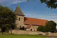 Church of St Dunstan |
| Dukes Place | West Peckham | Manor House | 18th century | 1 August 1952 | TQ6483652687 51°14′58″N 0°21′38″E |
1070672 | |
| Church of All Saints | Wouldham | Church | 11th century | 25 August 1959 | TQ7126364391 51°21′10″N 0°27′29″E |
1070490 | 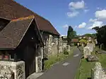 Church of All Saints |
| Starkey Castle | Wouldham | House | 1952 | 1 August 1952 | TQ7138365592 51°21′49″N 0°27′37″E |
1347808 | 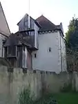 Starkey Castle |
| Church of St George | Wrotham | Church | Early 14th century | 25 August 1959 | TQ6118359189 51°18′32″N 0°18′40″E |
1236562 | 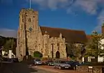 Church of St George |
| Tonbridge Castle | Tonbridge and Malling | Keep | Norman | 8 May 1950 | TQ5897446602 51°11′47″N 0°16′26″E |
1363369 |


Notes
- The date given is the date used by Historic England as significant for the initial building or that of an important part in the structure's description.
- Sometimes known as OSGB36, the grid reference is based on the British national grid reference system used by the Ordnance Survey.
- The "List Entry Number" is a unique number assigned to each listed building and scheduled monument by Historic England.
External links
![]() Media related to Grade I listed buildings in Tonbridge and Malling at Wikimedia Commons
Media related to Grade I listed buildings in Tonbridge and Malling at Wikimedia Commons
This article is issued from Wikipedia. The text is licensed under Creative Commons - Attribution - Sharealike. Additional terms may apply for the media files.