Grade II* listed buildings in Richmondshire
There are over 20,000 Grade II* listed buildings in England. This page is a list of these buildings in the district of Richmondshire in North Yorkshire.
Richmondshire
| Name | Location | Type | Completed [note 1] | Date designated | Grid ref.[note 2] Geo-coordinates |
Entry number [note 3] | Image |
|---|---|---|---|---|---|---|---|
| Old Powder Magazine | Arkengarthdale, Richmondshire | Powder Magazine | c. 1804 | 7 December 1966 | NY9986303429 54°25′35″N 2°00′13″W |
1130838 | 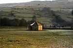 Old Powder Magazine |
| Chapel Range | Aske Park, Aske, Richmondshire | Apartment | 1887 | 4 February 1969 | NZ1777603442 54°25′34″N 1°43′39″W |
1131346 | 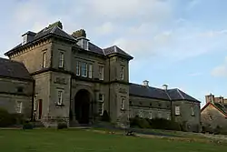 Chapel Range |
| West End House | West End, Askrigg, Richmondshire | House | Earlier | 25 March 1969 | SD9475591051 54°18′54″N 2°04′56″W |
1131195 |  |
| Church of Saint Andrew | Aysgarth, Richmondshire | Church | 10th century | 25 March 1969 | SE0119588534 54°17′33″N 1°58′59″W |
1318439 | |
| Countersett Hall | Countersett, Bainbridge, Richmondshire | Manor House | 1650 | 16 January 1952 | SD9190887909 54°17′12″N 2°07′33″W |
1316903 | 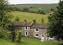 Countersett Hall |
| Old Hall | Barden, Richmondshire | Manor House | Early 15th century | 13 February 1967 | SE1429393508 54°20′13″N 1°46′54″W |
1318585 | |
| Old Hall | Bellerby, Richmondshire | House | Early 17th century | 13 February 1967 | SE1150892914 54°19′54″N 1°49′28″W |
1130859 | |
| Longridge Farmhouse and Outbuilding | Bishopdale, Richmondshire | Farmhouse | 1653 | 25 March 1969 | SD9604583190 54°14′40″N 2°03′44″W |
1318311 | |
| Smelter Farmhouse | Bishopdale, Richmondshire | Farmhouse | 1701 | 25 March 1969 | SD9645982873 54°14′30″N 2°03′21″W |
1318314 | |
| Bolton Old Hall | Bolton-on-Swale, Richmondshire | Tower House | 15th century | 4 February 1969 | SE2531799144 54°23′14″N 1°36′42″W |
1131520 | |
| Church of St Mary | Bolton-on-Swale, Richmondshire | Church | 14th century | 4 February 1969 | SE2523999168 54°23′15″N 1°36′46″W |
1131521 | 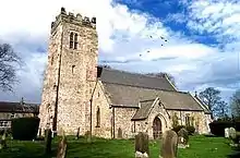 Church of St Mary |
| Catterick Bridge | Brough with St. Giles, Richmondshire | Bridge | 1422 | 4 February 1969 | SE2274499329 54°23′20″N 1°39′05″W |
1131481 | |
| Catterick Bridge | Brough with St. Giles, Richmondshire | Bridge | 1422 | 4 February 1969 | SE2273099369 54°23′21″N 1°39′05″W |
1317092 | 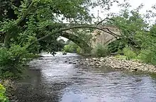 Catterick Bridge |
| Church of St Paulinus, Presbytery and attached Outbuildings | Brough Park, Brough with St. Giles, Richmondshire | Priests House | 1837 | 3 July 1987 | SE2155298106 54°22′41″N 1°40′11″W |
1179809 | 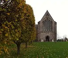 Church of St Paulinus, Presbytery and attached Outbuildings |
| Bear Park | Bear Park, Carperby-cum-Thoresby, Richmondshire | Manor House | 17th century | 16 January 1952 | SE0062888878 54°17′44″N 1°59′31″W |
1301406 | |
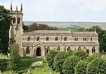
| Church of St Oswald | Castle Bolton,Richmondshire | Church | Late 14th century | 13 February 1967 | SE0336491875 54°19′21″N 1°56′59″W |
1130886 |  Church of St Oswald |
| Colburn Hall | Colburn, Richmondshire | Manor House | 1662 | 19 December 1951 | SE1961099228 54°23′17″N 1°41′58″W |
1131498 | .jpg.webp) Colburn Hall |
| Coach House and Stables of Constable Burton Hall | Burton Park, Constable Burton, Richmondshire | Tack Room | c. 1765 | 13 February 1967 | SE1633291245 54°19′00″N 1°45′02″W |
1318295 | |
| Church of Holy Trinity | Coverham, Coverham with Agglethorpe, Richmondshire | Cross | Anglo Saxon | 13 February 1967 | SE1039786369 54°16′22″N 1°50′31″W |
1130892 | |
| Coverham Abbey Gatehouse | Coverham Abbey, Coverham with Agglethorpe, Richmondshire | Gate | Early 16th century | 13 February 1967 | SE1047486319 54°16′21″N 1°50′26″W |
1178895 | 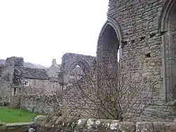 Coverham Abbey Gatehouse |
| Coverham Bridge | Coverham, Coverham with Agglethorpe, Richmondshire | Bridge | 15th century | 13 February 1967 | SE1043786210 54°16′17″N 1°50′28″W |
1130893 |  Coverham Bridge |
| Garth Cottage | Coverham Abbey, Coverham with Agglethorpe, Richmondshire | House | Medieval | 13 February 1967 | SE1058586383 54°16′23″N 1°50′20″W |
1302197 | |
| Stone Effigies of Knights about 7m east of Coverham Abbey House | Coverham Abbey, Coverham with Agglethorpe, Richmondshire | Effigy | Late 13th century | 24 January 1986 | SE1060686368 54°16′22″N 1°50′19″W |
1130897 | |
| Dalton Hall | Dalton, Richmondshire | Fortified Manor House | 15th century | 4 February 1969 | NZ1106409020 54°28′35″N 1°49′51″W |
1131349 | |
| Church of Saint Michael and All Angels | Downholme, Richmondshire | Church | 12th century | 4 February 1969 | SE1106898334 54°22′49″N 1°49′52″W |
1179437 |  Church of Saint Michael and All Angels |
| Downholme Bridge | Downholme, Richmondshire | Bridge | Late 17th century | 4 February 1969 | SE1135299176 54°23′17″N 1°49′36″W |
1179514 | 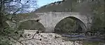 Downholme Bridge |
| Downholme Bridge | Downholme, Richmondshire | Bridge | Late 17th century | 4 February 1969 | SE1135499176 54°23′17″N 1°49′36″W |
1131326 | Downholme Bridge |
| Easby Hall and Nos 1 and 2 Easby Court | Easby, Richmondshire | Apartment | c. 1730 | 4 February 1969 | NZ1871000356 54°23′54″N 1°42′48″W |
1318260 | |
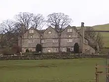
| Braithwaite Hall | East Witton, Richmondshire | Manor House | 1667 | 25 June 1985 | SE1173485773 54°16′03″N 1°49′17″W |
1318557 | |
| Church of St Mary the Virgin | Eryholme, Richmondshire | Church | c. 1200 | 18 March 1968 | NZ3206509008 54°28′32″N 1°30′24″W |
1131336 | 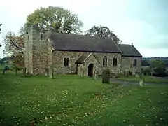 Church of St Mary the Virgin |
| Church of St Andrew | Finghall, Richmondshire | Church | C9 | 13 February 1967 | SE1906390166 54°18′24″N 1°42′31″W |
1131477 | |
| Dovecote | Forcett Park, Forcett and Carkin, Richmondshire | Dovecote | Mid - Late 18th century | 4 February 1969 | NZ1747412485 54°30′27″N 1°43′54″W |
1157745 | 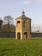 Dovecote |
| East Gateway and Lodges | Forcett Park, Forcett and Carkin, Richmondshire | Gate | 19th century | 4 February 1969 | NZ1750612305 54°30′21″N 1°43′52″W |
1316917 | |
| Grotto and Icehouse | Forcett Park, Forcett and Carkin, Richmondshire | Icehouse | Late 18th century | 4 February 1969 | NZ1700012146 54°30′16″N 1°44′20″W |
1157748 | |
| Stable Block to East of Forcett Hall | Forcett Park, Forcett and Carkin, Richmondshire | Gate Pier | Late 18th century | 4 February 1969 | NZ1728912352 54°30′22″N 1°44′04″W |
1157736 | |
| Hartforth Hall | Hartforth, Gilling with Hartforth and Sedbury, Richmondshire | Country House | 1744 | 4 February 1969 | NZ1627606931 54°27′27″N 1°45′02″W |
1131933 | |
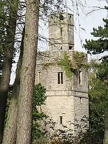
| Summer House about 150m south-west of Gillingwood Hall | Gilling with Hartforth and Sedbury, Richmondshire | Summerhouse | Early - Mid 18th century | 4 February 1969 | NZ1703104645 54°26′13″N 1°44′20″W |
1316932 | |
| Blackburn Hall | Grinton, Richmondshire | Clerical Dwelling | Medieval | 4 September 1952 | SE0462598449 54°22′53″N 1°55′49″W |
1130810 | 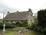 Blackburn Hall |
| Grinton Smelting Mill and Watercourse | Cogden Moor, Grinton, Richmondshire | Smelt Mill | c. 1820 | 13 February 1973 | SE0487796425 54°21′48″N 1°55′35″W |
1318580 | |
| Gayle Mill | Gayle, Hawes, Richmondshire | Saw Mill | 19th century | 25 March 1969 | SD8711689382 54°18′00″N 2°11′58″W |
1132000 | |
| The Old Grammar School and Grammar School House and attached Wall and Railings | Kirby Hill, Richmondshire | House | Early 18th century | 19 December 1951 | NZ1403706576 54°27′16″N 1°47′06″W |
1131319 |  The Old Grammar School and Grammar School House and attached Wall and Railings |
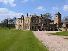
| Leyburn Hall | Leyburn, Richmondshire | Country House | c. 1750 | 13 February 1967 | SE1103590484 54°18′35″N 1°49′55″W |
1130898 | .jpg.webp) Leyburn Hall |
| Coleby Hall | Grange, Low Abbotside, Richmondshire | Manor House | 1655 | 9 July 1986 | SD9329991154 54°18′57″N 2°06′16″W |
1316922 | |
| Church of All Saints | Manfield, Richmondshire | Church | 1796-1802 | 18 March 1968 | NZ2226813377 54°30′55″N 1°39′27″W |
1131339 |  Church of All Saints |
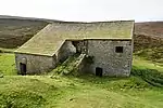
| Marrick Priory Farmhouse | Marrick Priory, Marrick, Richmondshire | Farmhouse | Earlier | 7 December 1966 | SE0668697759 54°22′31″N 1°53′55″W |
1130821 |  Marrick Priory Farmhouse |
| Church of St Edmund King and Martyr | Marske, Richmondshire | Parish Church | 12th century | 4 February 1969 | NZ1045500501 54°24′00″N 1°50′26″W |
1301436 |  Church of St Edmund King and Martyr |
| Marske Hall | Marske, Richmondshire | Apartment | Late 16th century or early 17th century | 19 December 1951 | NZ1038200345 54°23′54″N 1°50′30″W |
1157772 | |
| Paradise | Low Row, Melbecks, Richmondshire | House | 1653 | 21 April 1986 | SD9822997884 54°22′35″N 2°01′44″W |
1301785 | |
| Church of St James | Melsonby, Richmondshire | Cross | c800 | 4 February 1969 | NZ2011408444 54°28′15″N 1°41′28″W |
1167040 | |
| East Hall | Middleton Tyas, Richmondshire | House | 1713 | 4 February 1969 | NZ2280905987 54°26′56″N 1°38′59″W |
1157407 | |
| Middleton Lodge | Middleton Tyas, Richmondshire | Country House | 1777-1780 | 4 February 1969 | NZ2235106825 54°27′23″N 1°39′24″W |
1317085 | |
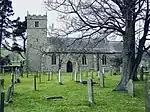
| Church of Saint Mary | Muker, Richmondshire | Church | 1580 | 7 December 1966 | SD9105597880 54°22′35″N 2°08′21″W |
1302046 | |
| Ivelet Bridge | Ivelet, Muker, Richmondshire | Bridge | Late 16th century | 7 December 1966 | SD9331097798 54°22′32″N 2°06′16″W |
1179137 | 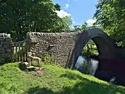 Ivelet Bridge |
| Oxnop Hall | Low Oxnop, Muker, Richmondshire | Farmhouse | 1685 | 7 December 1966 | SD9310497390 54°22′19″N 2°06′28″W |
1131529 | |
| Dalesend | Patrick Brompton, Richmondshire | Country House | Early 18th century | 13 February 1967 | SE2203790681 54°18′41″N 1°39′46″W |
1301373 | |
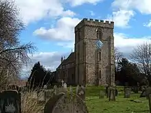
| Church of St Mary | Redmire, Richmondshire | Church | 12th century | 13 February 1967 | SE0508790800 54°18′46″N 1°55′24″W |
1130873 | .jpg.webp) Church of St Mary |
| Draycott Hall | Fremington, Reeth, Fremington and Healaugh, Richmondshire | Apartment | Late 18th century | 7 December 1966 | SE0459898951 54°23′10″N 1°55′51″W |
1317107 | 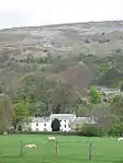 Draycott Hall |
| Garden Wall at Hill House, Gates and Gate Piers at Hill House | Richmond, Richmondshire | Gate | 18th century | 15 October 1973 | NZ1746301284 54°24′24″N 1°43′57″W |
1240977 | |
| Hill House (three Dwellings) | Richmond, Richmondshire | House | Earlier | 1 August 1952 | NZ1744401307 54°24′25″N 1°43′58″W |
1260753 | |
| King's Head Hotel | Richmond, Richmondshire | Hotel | late C17/early 18th century | 1 August 1952 | NZ1715300931 54°24′13″N 1°44′14″W |
1240397 | 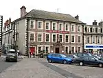 King's Head Hotel |
| Old Grand Stand | Old Race Course, Richmond, Richmondshire | Grandstand | c. 1775 | 1 August 1952 | NZ1596702194 54°24′54″N 1°45′20″W |
1131277 | 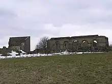 Old Grand Stand |
| Parish Church of St Mary | Richmond, Richmondshire | Parish Church | Late 12th century | 1 August 1952 | NZ1743201066 54°24′17″N 1°43′59″W |
1289814 | |
| The Bar | Richmond, Richmondshire | Town Wall | c. 1312 | 1 August 1952 | NZ1703200737 54°24′07″N 1°44′21″W |
1211647 | 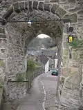 The Bar |
| The Cross | Richmond, Richmondshire | Obelisk | 1771 | 1 August 1952 | NZ1709900879 54°24′11″N 1°44′17″W |
1240522 |  The Cross |
| The Eleanor Bowes Hospital | Richmond, Richmondshire | Almshouse | 1607 | 1 August 1952 | NZ1757401284 54°24′24″N 1°43′51″W |
1289900 | 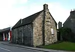 The Eleanor Bowes Hospital |
| The Green Bridge | Richmond, Richmondshire | Bridge | 1789 | 1 August 1952 | NZ1695600605 54°24′02″N 1°44′25″W |
1318388 | _(geograph_2530352).jpg.webp) The Green Bridge |
| The Grove | Richmond, Richmondshire | Town House | 1750 | 1 August 1952 | NZ1726901010 54°24′15″N 1°44′08″W |
1318419 | 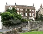 The Grove |
| The Temple | Richmond, Richmondshire | Pele Tower | Earlier than c1746 | 1 August 1952 | NZ1671200737 54°24′07″N 1°44′39″W |
1131225 |  The Temple |
| 21, Trinity Church Square | Richmond, Richmondshire | House | Early 18th century | 1 August 1952 | NZ1717500871 54°24′11″N 1°44′13″W |
1096972 | .jpg.webp) 21, Trinity Church Square |
| 15, Bridge Street | Richmond, Richmondshire | House | Early 18th century | 1 August 1952 | NZ1695900704 54°24′05″N 1°44′25″W |
1131259 | |
| 47, Newbiggin | Richmond, Richmondshire | House | 18th century | 1 August 1952 | NZ1684200936 54°24′13″N 1°44′31″W |
1240776 | |
| 58 and 59, Market Place | Richmond, Richmondshire | House | Mid 18th century | 1 August 1952 | NZ1724300870 54°24′11″N 1°44′09″W |
1240521 | |
| 9, Market Place | Richmond, Richmondshire | House | Early 18th century | 1 August 1952 | NZ1717200928 54°24′13″N 1°44′13″W |
1240394 | |
| Manor House | Skeeby, Richmondshire | House | Early-Mid 17th century | 19 December 1951 | NZ2002902612 54°25′07″N 1°41′34″W |
1157732 | 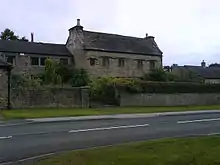 Manor House |
| Richmond Bridge | Slee Gill, Richmond, Richmondshire | Bridge | 1788-9 | 4 February 1969 | NZ1696000582 54°24′02″N 1°44′25″W |
1179652 | 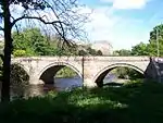 Richmond Bridge |
| Richmond Garden and Farm Supply Centre | St. Martin's, Richmondshire | Booking Office | c. 1846 | 4 March 1969 | NZ1765200870 54°24′11″N 1°43′47″W |
1157668 | |
| Old Hall | Town Head, Thoralby, Richmondshire | House | 1641 | 25 March 1969 | SD9951686594 54°16′30″N 2°00′32″W |
1179924 | |
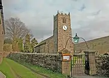
| Church of St Oswald | Thornton Steward, Richmondshire | Cross | Saxon | 15 February 1967 | SE1705086939 54°16′40″N 1°44′23″W |
1130925 |  Church of St Oswald |
| Hauxwell Hall | Hauxwell Hall, West Hauxwell, Richmondshire | Country House | Late 17th century | 13 February 1967 | SE1618193335 54°20′07″N 1°45′10″W |
1301772 | |
| Swinithwaite Hall | Swinithwaite, West Witton, Richmondshire | Country House | 1767 | 13 February 1967 | SE0456589240 54°17′56″N 1°55′53″W |
1179461 | |


.jpg.webp)


Notes
- The date given is the date used by Historic England as significant for the initial building or that of an important part in the structure's description.
- Sometimes known as OSGB36, the grid reference is based on the British national grid reference system used by the Ordnance Survey.
- The "List Entry Number" is a unique number assigned to each listed building and scheduled monument by Historic England.
External links
![]() Media related to Grade II* listed buildings in Richmondshire at Wikimedia Commons
Media related to Grade II* listed buildings in Richmondshire at Wikimedia Commons
This article is issued from Wikipedia. The text is licensed under Creative Commons - Attribution - Sharealike. Additional terms may apply for the media files.