Grade II* listed buildings in Test Valley
There are over 20,000 Grade II* listed buildings in England. This page is a list of these buildings in the district of Test Valley in Hampshire.
Test Valley
| Name | Location | Type | Completed [note 1] | Date designated | Grid ref.[note 2] Geo-coordinates |
Entry number [note 3] | Image |
|---|---|---|---|---|---|---|---|
| Pennymarsh | Little Ann, Abbotts Ann, Test Valley | House | late 16th century or early 17th century | 20 December 1960 | SU3319543673 51°11′29″N 1°31′35″W |
1279211 |  |
| The Rectory | Abbotts Ann, Test Valley | House | Queen Anne | 20 December 1960 | SU3320343609 51°11′27″N 1°31′35″W |
1228705 |  The Rectory |
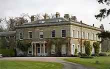
| Ampfield House | Ampfield, Test Valley | Country House | Mid 18th century | 29 May 1957 | SU3988723245 51°00′26″N 1°25′58″W |
1093686 |  Ampfield House |
| Church of St Mary | Amport, Test Valley | Parish Church | c. 1320 | 21 December 1960 | SU2994544202 51°11′47″N 1°34′22″W |
1093280 | 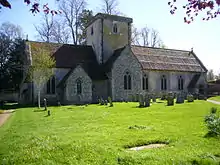 Church of St Mary |
| The Firs | Amport, Test Valley | Apartment | Late 17th century | 20 December 1960 | SU3016944209 51°11′47″N 1°34′11″W |
1155840 | |
| 89, 91 & 93 High Street, Andover | Andover, Test Valley | Timber Framed Building | Built 1445-1455 | 24 February 1950 | SU3648945677 51°12′33″N 1°28′45″W |
1264607 | |
| Guildhall | Andover, Test Valley | Guildhall | 1950 | 24 February 1950 | SU3647145528 51°12′28″N 1°28′45″W |
1236337 |  Guildhall |
| Danebury Hotel (Star and Garter Hotel) | Andover, Test Valley | Coaching Inn | Early 19th century | 24 February 1950 | SU3650745386 51°12′23″N 1°28′44″W |
1093497 |  Danebury Hotel (Star and Garter Hotel) |
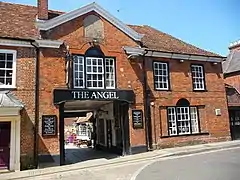
| The Angel Inn | Andover, Test Valley | Courtyard Inn | Built 1445-55 | 24 February 1950 | SU3648245695 51°12′33″N 1°28′45″W |
1093460 | |
| Hill House | Appleshaw, Test Valley | House | Queen Anne | 20 December 1960 | SU3036548633 51°14′10″N 1°33′59″W |
1339464 | |
| Mead House | Appleshaw, Test Valley | House | Queen Anne | 20 December 1960 | SU3067248320 51°14′00″N 1°33′43″W |
1339042 | |
| Redenham House | Redenham, Appleshaw, Test Valley | Country House | Early 19th century | 20 October 1960 | SU2943249348 51°14′33″N 1°34′47″W |
1093912 | |
| The Old Vicarage | Appleshaw, Test Valley | House | Mid 18th century | 20 December 1960 | SU3041148843 51°14′17″N 1°33′57″W |
1229290 | |
| Church of St Mary | Ashley, Test Valley | Parish Church | Early 12th century | 29 May 1957 | SU3849230903 51°04′34″N 1°27′07″W |
1339063 | |
| Awbridge Danes House | Awbridge Danes Estate, Awbridge, Test Valley | Country House | 1822-25 | 4 March 1986 | SU3187323051 51°00′21″N 1°32′50″W |
1093655 | |
| Church Farmhouse and Garden Wall | Barton Stacey, Test Valley | House | 15th century | 7 January 1952 | SU4336441380 51°10′12″N 1°22′52″W |
1093439 | |
| Church of All Saints | Barton Stacey, Test Valley | Parish Church | Norman | 20 December 1960 | SU4348841145 51°10′04″N 1°22′46″W |
1302289 |  Church of All Saints |
| Pittleworth Manor House | Bossington, Test Valley | House | 16th century | 29 May 1957 | SU3276929679 51°03′56″N 1°32′01″W |
1157769 | |
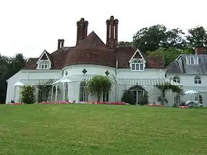
| Braishfield Manor House | Braishfield, Test Valley | Country House | Mid 18th century | 29 May 1957 | SU3755026272 51°02′05″N 1°27′57″W |
1157292 |  Braishfield Manor House |
| Broughton Manor House | Broughton, Test Valley | House | c. 1800 | 29 May 1957 | SU3117532879 51°05′40″N 1°33′22″W |
1166844 | |
| Church of St Mary the Virgin | Broughton, Test Valley | Parish Church | 12th century | 29 May 1957 | SU3089432914 51°05′41″N 1°33′37″W |
1093875 |  Church of St Mary the Virgin |
| Dovecote in Churchyard 50m north of Chancel of St Mary's Church | Broughton, Test Valley | Dovecote | 17th century | 29 May 1957 | SU3090432966 51°05′43″N 1°33′36″W |
1166461 |  Dovecote in Churchyard 50m north of Chancel of St Mary's Church |
| Grandfathers | Broughton, Test Valley | House | c. 1700 | 29 May 1957 | SU3129432641 51°05′32″N 1°33′16″W |
1166852 | |
| The Lindens | Broughton, Test Valley | House | Mid 18th century | 29 May 1957 | SU3063133168 51°05′49″N 1°33′50″W |
1339070 | |
| The Old Rectory | Broughton, Test Valley | House | 15th century | 29 May 1957 | SU3089033050 51°05′45″N 1°33′37″W |
1093854 | |
| Church of St Michael | Lower Bullington, Bullington, Test Valley | Parish Church | Norman | 20 December 1960 | SU4548541228 51°10′07″N 1°21′03″W |
1093440 |  Church of St Michael |
| Northwood House | Chilbolton, Test Valley | House | c. 1700 | 7 January 1952 | SU3956540249 51°09′36″N 1°26′08″W |
1178985 | |
| Church of St Winfrith | East Dean, Test Valley | Parish Church | C12/13 | 29 May 1957 | SU2734126746 51°02′22″N 1°36′41″W |
1093769 |  Church of St Winfrith |
| East Dean Manor House | East Dean, Test Valley | House | Early 18th century | 29 May 1957 | SU2724626779 51°02′23″N 1°36′46″W |
1157343 | |
| Park Farmhouse | East Dean, Test Valley | Farmhouse | 17th century | 29 May 1957 | SU2686327107 51°02′34″N 1°37′06″W |
1301571 | |
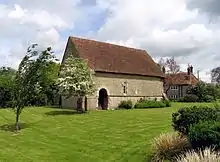
| Barn 30m east of Manor Farmhouse | Manor Farm, East Tytherley, Test Valley | Aisled Barn | c. 1600 | 11 April 1986 | SU2923829504 51°03′51″N 1°35′03″W |
1093739 | |
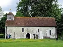
| Church of St Peter | East Tytherley, Test Valley | Parish Church | Mid 13th century | 11 April 1986 | SU2923429000 51°03′35″N 1°35′03″W |
1301531 |  Church of St Peter |
| Rolle House | East Tytherley, Test Valley | House | C20 | 29 May 1957 | SU2943128792 51°03′28″N 1°34′53″W |
1301542 | |
| Netherton House | Netherton, Faccombe, Test Valley | House | 1964 | 7 January 1952 | SU3763257770 51°19′04″N 1°27′41″W |
1093358 | |
| Church of All Saints | Houghton, Test Valley | Parish Church | Early 12th century | 29 May 1957 | SU3414032657 51°05′32″N 1°30′50″W |
1339061 | 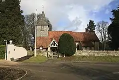 Church of All Saints |
| Houghton Lodge | Houghton Lodge, Houghton, Test Valley | Fishing Lodge | c. 1800 | 7 February 1986 | SU3440133121 51°05′47″N 1°30′36″W |
1093833 | |
| Old Rectory | Houghton, Test Valley | House | Mid 18th century | 29 May 1957 | SU3418132650 51°05′32″N 1°30′48″W |
1093859 | |
| Garvery | Hurstbourne Tarrant, Test Valley | House | Early 19th century | 20 December 1960 | SU3827953167 51°16′35″N 1°27′09″W |
1093339 | |
| Ibthorpe Farm House | Ibthorpe, Hurstbourne Tarrant, Test Valley | House | Early 18th century | 20 December 1960 | SU3780953688 51°16′52″N 1°27′33″W |
1339371 | |
| Ibthorpe House | Hurstbourne Tarrant, Test Valley | House | Mid 18th century | 20 December 1960 | SU3766753798 51°16′56″N 1°27′41″W |
1093341 |  Ibthorpe House |
| Ibthorpe Manor Farmhouse | Hurstbourne Tarrant, Test Valley | House | Early 18th century | 20 December 1960 | SU3789953800 51°16′56″N 1°27′29″W |
1155768 | |
| Rookery Farmhouse | Hurstbourne Tarrant, Test Valley | House | 1776 | 20 December 1960 | SU3816453083 51°16′32″N 1°27′15″W |
1093338 | |
| Kimpton Manor Farmhouse | Kimpton, Test Valley | House | Early 19th century | 20 December 1960 | SU2814546666 51°13′07″N 1°35′54″W |
1339407 | |
| Church of St John the Baptist | Upper Eldon, King's Somborne, Test Valley | Church | Late 12th century | 29 May 1957 | SU3643727792 51°02′54″N 1°28′54″W |
1093786 | |
| Church of St Peter and St Paul | King's Somborne, Test Valley | Parish Church | 12th century | 29 May 1957 | SU3602230979 51°04′37″N 1°29′14″W |
1339113 |  Church of St Peter and St Paul |
| Rookley House | Up Somborne, Kings Somborne, Test Valley | House | Early 18th century | 5 December 1955 | SU3954732753 51°05′34″N 1°26′12″W |
1303305 | |
| Sunken Garden on South of West Wing of Marsh Court | Marsh Court, King's Somborne, Test Valley | Garden | 1901–1905 | 7 February 1986 | SU3563033594 51°06′02″N 1°29′33″W |
1093807 | |
| The Old Vicarage | King's Somborne, Test Valley | House | Early 18th century | 29 May 1957 | SU3615931077 51°04′40″N 1°29′07″W |
1296888 | |
| Church of St Nicholas | Leckford, Test Valley | Parish Church | 13th century | 29 May 1957 | SU3739037639 51°08′13″N 1°28′01″W |
1093181 |  Church of St Nicholas |
| Church of All Saints | Little Somborne, Test Valley | Church | Saxon | 29 May 1957 | SU3821632655 51°05′31″N 1°27′20″W |
1167714 | |
| School Farmhouse | Lockerley, Test Valley | Farmhouse | 16th century | 29 May 1957 | SU3050426123 51°02′01″N 1°33′59″W |
1296775 | |
| Longparish House | Longparish, Test Valley | Country House | Late 17th century | 7 January 1952 | SU4364244831 51°12′04″N 1°22′36″W |
1093433 | |
| Church of St Peter | Melchet Park and Plaitford, Test Valley | Parish Church | 13th century | 17 November 1986 | SU2778220316 50°58′54″N 1°36′20″W |
1157584 |  Church of St Peter |
| Melchet Court (St Edwards School) | Melchet Park, Melchet Park and Plaitford, Test Valley | Country House | 1863 | 17 November 1986 | SU2707222266 50°59′57″N 1°36′56″W |
1339192 |  Melchet Court (St Edwards School) |
| Church of St Andrew | Timsbury, Michelmersh and Timsbury, Test Valley | Church | 13th century | 29 May 1957 | SU3457524556 51°01′10″N 1°30′30″W |
1093717 |  Church of St Andrew |
| Church of St Mary | Michelmersh and Timsbury, Test Valley | Parish Church | 12th century | 29 May 1957 | SU3460826622 51°02′17″N 1°30′28″W |
1296690 | 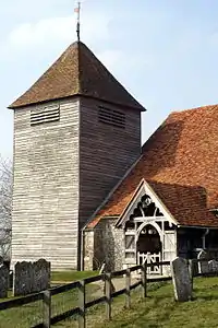 Church of St Mary |
| Manor Farm House | Michelmersh and Timsbury, Test Valley | Farmhouse | c. 1700 | 22 March 1979 | SU3521526390 51°02′09″N 1°29′57″W |
1093754 | |
| Michelmersh Court | Michelmersh and Timsbury, Test Valley | House | 1986 | 29 May 1957 | SU3467526674 51°02′18″N 1°30′25″W |
1093751 | |
| Staddle Barn 15m north of Michelmersh Manor Farmhouse | Michelmersh and Timsbury, Test Valley | Staddle Stone | Mid 18th century | 22 March 1979 | SU3518926407 51°02′09″N 1°29′58″W |
1093714 | |
| Church of St Mary | Monxton, Test Valley | Parish Church | Norman | 30 April 1985 | SU3128744572 51°11′58″N 1°33′13″W |
1093882 |  Church of St Mary |
| Stable Block | Mottisfont Abbey, Mottisfont, Test Valley | Gate Pier | 1836 | 29 May 1957 | SU3263027017 51°02′30″N 1°32′09″W |
1093729 |  Stable Block |
| Fifehead Manor Hotel | Middle Wallop, Nether Wallop, Test Valley | Manor House | 17th century | 29 May 1957 | SU2893337884 51°08′22″N 1°35′16″W |
1093165 | |
| Church of St John the Baptist | North Baddesley, Test Valley | Parish Church | 11th century | 29 May 1957 | SU4025820862 50°59′09″N 1°25′40″W |
1093668 |  Church of St John the Baptist |
| Church of St Boniface | Nursling and Rownhams, Test Valley | Parish Church | Saxon | 29 May 1957 | SU3593316473 50°56′48″N 1°29′24″W |
1093670 |  Church of St Boniface |
| Church of St Peter | Over Wallop, Test Valley | Church | 12th century | 29 May 1957 | SU2842638241 51°08′34″N 1°35′42″W |
1093127 | 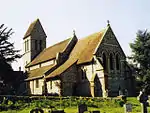 Church of St Peter |
| Townsend Farm House | Over Wallop, Test Valley | Farmhouse | earlier core | 29 May 1957 | SU2800238382 51°08′38″N 1°36′04″W |
1093122 | |
| Church of St Michael and All Angels | Weyhill, Penton Grafton, Test Valley | Parish Church | Norman | 20 December 1960 | SU3176246642 51°13′05″N 1°32′48″W |
1229819 | 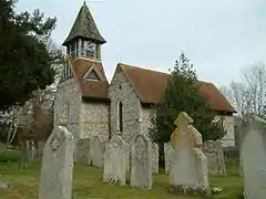 Church of St Michael and All Angels |
| Clanville House | Clanville, Penton Grafton, Test Valley | House | Early 18th century | 20 December 1960 | SU3188249133 51°14′26″N 1°32′41″W |
1278896 | |
| Ramridge House | Ramridge Park, Penton Grafton, Test Valley | Country House | c. 1740 | 20 December 1960 | SU3127047767 51°13′42″N 1°33′13″W |
1229808 |  Ramridge House |
| Holy Trinity Church | Penton Mewsey, Test Valley | Parish Church | 14th century | 20 December 1960 | SU3296747422 51°13′30″N 1°31′45″W |
1278801 | 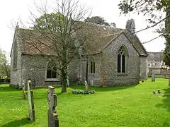 Holy Trinity Church |
| Church of St Michael | Quarley, Test Valley | Bell Tower | 11th century | 20 December 1960 | SU2728043985 51°11′40″N 1°36′40″W |
1339411 |  Church of St Michael |
| Broadwater House | Romsey, Test Valley | House | 18th century | 28 August 1951 | SU3524221007 50°59′15″N 1°29′57″W |
1277499 | |
| Railings at Broadwater House | Romsey, Test Valley | Gate | 4 December 1972 | SU3523621005 50°59′15″N 1°29′58″W |
1231605 | | |
| Bradbeers (Dolphin Hotel) | Romsey, Test Valley | Hotel | Early 19th century | 28 August 1951 | SU3525821152 50°59′19″N 1°29′57″W |
1231843 | 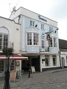 Bradbeers (Dolphin Hotel) |
| Former Corn Exchange | Romsey, Test Valley | Corn Exchange | 1864 | 28 August 1951 | SU3524021171 50°59′20″N 1°29′57″W |
1231877 |  Former Corn Exchange |
| Luzborough House | Romsey, Test Valley | House | Late 17th century | 22 April 1985 | SU3770920734 50°59′05″N 1°27′51″W |
1232586 |  Luzborough House |
| The White Horse Hotel | Romsey, Test Valley | House | 18th century | 28 August 1951 | 49°46′01″N 7°33′26″W | 1232184 |  The White Horse Hotel |
| 1 Church Court | Romsey, Test Valley | Timber Framed House | partly 16th century | 28 August 1951 | SU3520721279 50°59′23″N 1°29′59″W |
1231711 |  1 Church Court |
| 37 and 39 Church Street | Romsey, Test Valley | House | Late 18th century | 28 August 1951 | SU3518621376 50°59′27″N 1°30′00″W |
1231749 | |
| Ashfield Lodge | Broadlands Estate, Romsey Extra, Test Valley | Timber Framed House | 1870 | 17 November 1986 | SU3621619944 50°58′40″N 1°29′08″W |
1301303 | |
| Barn 40m north of Moorcourt | Romsey Extra, Test Valley | Timber Framed Barn | c. 1700 | 29 May 1957 | SU3453217044 50°57′06″N 1°30′35″W |
1166645 | |
| Moorcourt | Romsey Extra, Test Valley | House | 15th century | 29 May 1957 | SU3452517002 50°57′05″N 1°30′36″W |
1093649 | |
| Orangery | Broadlands Estate, Romsey Extra, Test Valley | Orangery | 18th century | 17 November 1986 | SU3543420096 50°58′45″N 1°29′48″W |
1301341 | |
| Ranvilles Farmhouse | Romsey Extra, Test Valley | Farmhouse | 16th century | 29 May 1957 | SU3370718853 50°58′05″N 1°31′17″W |
1339186 | |
| Stanbridge Earls | Stanbridge Earls, Romsey Extra, Test Valley | House | Mid 14th century | 29 May 1957 | SU3377323194 51°00′26″N 1°31′12″W |
1166424 |  Stanbridge Earls |
| Fairways, the Grosvenor Hotel | Stockbridge, Test Valley | House | Late 18th century | 29 May 1957 | SU3560035123 51°06′51″N 1°29′34″W |
1093088 |  Fairways, the Grosvenor Hotel |
| Kings Head House, Lane Antiques, Lane House, Leyanne Salon | Stockbridge, Test Valley | House | Formerly | 27 November 1984 | SU3581235091 51°06′50″N 1°29′23″W |
1093091 | |
| Old Town Hall | Stockbridge, Test Valley | Town Hall | Dated 1810 | 29 May 1957 | SU3549935104 51°06′51″N 1°29′39″W |
1093093 |  Old Town Hall |
| Remains of Old St Peter's Church | Stockbridge, Test Valley | Church | c. 1300 | 27 November 1984 | SU3596134997 51°06′47″N 1°29′16″W |
1302362 |  Remains of Old St Peter's Church |
| Church of St Thomas of Canterbury | Tangley, Test Valley | Parish Church | Early Medieval | 27 September 1984 | SU3340952447 51°16′13″N 1°31′21″W |
1156218 |  Church of St Thomas of Canterbury |
| Church of All Saints | Upper Clatford, Test Valley | Parish Church | 12th century | 20 December 1960 | SU3571643559 51°11′25″N 1°29′25″W |
1278644 |  Church of All Saints |
| Vernham Manor House | Vernhams Dean, Test Valley | House | Medieval | 20 December 1960 | SU3517656608 51°18′27″N 1°29′48″W |
1156458 | |
| Church Farmhouse | West Tytherley, Test Valley | Farmhouse | c. 1300 | 11 April 1986 | SU2757629754 51°03′59″N 1°36′28″W |
1093704 | |
| Dean House | West Tytherley, Test Valley | House | 1978 | 24 January 1978 | SU2576827278 51°02′39″N 1°38′02″W |
1135717 | |
| Norman Court House | Northaw School, West Tytherley, Test Valley | Country House | c. 1752 | 19 February 1986 | SU2651930926 51°04′37″N 1°37′22″W |
1173046 | |
| Church of St Peter and Holy Cross | Wherwell, Test Valley | Cross | Saxon | 21 March 1984 | SU3914640822 51°09′55″N 1°26′29″W |
1179499 |  Church of St Peter and Holy Cross |
| The Priory | Wherwell, Test Valley | Country House | Early 18th century | 7 January 1952 | SU3918040736 51°09′52″N 1°26′28″W |
1301832 | |
| 28 Church Street | Wherwell, Test Valley | House | 15th century | 20 December 1960 | SU3912440933 51°09′59″N 1°26′31″W |
1093414 | |


Notes
- The date given is the date used by Historic England as significant for the initial building or that of an important part in the structure's description.
- Sometimes known as OSGB36, the grid reference is based on the British national grid reference system used by the Ordnance Survey.
- The "List Entry Number" is a unique number assigned to each listed building and scheduled monument by Historic England.
External links
![]() Media related to Grade II* listed buildings in Hampshire at Wikimedia Commons
Media related to Grade II* listed buildings in Hampshire at Wikimedia Commons
This article is issued from Wikipedia. The text is licensed under Creative Commons - Attribution - Sharealike. Additional terms may apply for the media files.
