Grade I listed buildings in South Hams
There are over 9,000 Grade I listed buildings in England. This page is a list of these buildings in the district of South Hams in Devon.
South Hams
| Name | Location | Type | Completed [note 1] | Date designated | Grid ref.[note 2] Geo-coordinates |
Entry number [note 3] | Image |
|---|---|---|---|---|---|---|---|
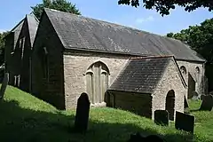
| Church of St David | Ashprington, South Hams | Parish Church | 13th century or 14th century | 9 February 1961 | SX8185557151 50°24′08″N 3°39′50″W |
1108393 | 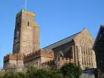 Church of St David |
| Sharpham House | Ashprington, South Hams | Villa | c. 1770 | 11 November 1952 | SX8270157870 50°24′32″N 3°39′08″W |
1108385 | |
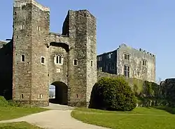
| Berry Pomeroy Castle | Berry Pomeroy, South Hams | Castle | c. 1300 | 9 February 1961 | SX8390362297 50°26′56″N 3°38′12″W |
1108571 | |
| Church of St Mary | Berry Pomeroy, South Hams | Church | 15th century | 9 February 1961 | SX8289260999 50°26′14″N 3°39′01″W |
1108535 | 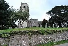 Church of St Mary |
| Church of St Mary | Bickleigh, South Hams | Parish Church | 15th century | 29 March 1960 | SX5208762310 50°26′31″N 4°05′04″W |
1107473 | 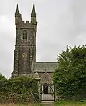 Church of St Mary |
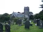
| Church of St Michael | Blackawton, South Hams | Parish Church | 14th century | 26 January 1967 | SX8047350951 50°20′47″N 3°40′53″W |
1108023 | 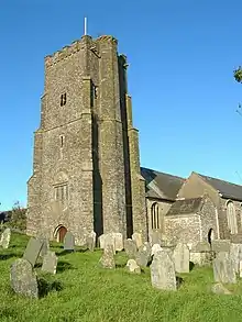 Church of St Michael |
| Church of St Mary | Brixton, South Hams | Parish Church | circa 13th century | 29 March 1960 | SX5538752197 50°21′07″N 4°02′03″W |
1325213 | 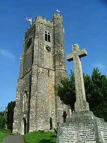 Church of St Mary |
| Higher Hareston | Brixton, South Hams | Hall House | circa late 15th century early 16th century | 29 March 1984 | SX5660353433 50°21′48″N 4°01′03″W |
1107828 |  |
| Gatehouse to Leigh Barton Farm | Leigh, Churchstow, South Hams | Boundary Wall | 15th century | 28 July 1989 | SX7202646727 50°18′24″N 3°47′55″W |
1168488 | |
| Leigh Barton Farmhouse | Leigh, Churchstow, South Hams | Kitchen | 15th century | 28 July 1989 | SX7202446699 50°18′23″N 3°47′55″W |
1108145 | |
| Church of St Michael | Cornwood, South Hams | Parish Church | c. 1300 | 29 March 1960 | SX6043159365 50°25′03″N 3°57′57″W |
1107445 |  Church of St Michael |
| Fardel Manor House Including Walls to North West and South West | Fardel, Cornwood, South Hams | Cross Wing House | Circa 15th century | 23 April 1982 | SX6121457431 50°24′01″N 3°57′15″W |
1162392 | |
| Church of St Peter | Cornworthy, South Hams | Parish Church | by 1878 | 9 February 1961 | SX8294855547 50°23′17″N 3°38′52″W |
1291647 |  Church of St Peter |
| Priory Gatehouse | Cornworthy, South Hams | Augustinian Nunnery | founded 1205-1238 | 9 February 1961 | SX8217555606 50°23′19″N 3°39′32″W |
1291588 | .jpg.webp) Priory Gatehouse |
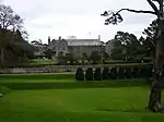
| Dartington Hall | Dartington, South Hams | Country House | 1388-1399 | 11 November 1952 | SX7982062668 50°27′05″N 3°41′39″W |
1108353 | |
| Tower of Former Church of St Mary Immediately West of Dartington Hall | Dartington Hall, Dartington, South Hams | Tower | 1993 | 9 February 1961 | SX7978062694 50°27′06″N 3°41′41″W |
1219690 | 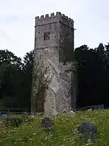 Tower of Former Church of St Mary Immediately West of Dartington Hall |
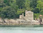
| Bearscove Castle | Dartmouth, South Hams | Artillery Castle | by 1537 | 14 September 1949 | SX8786550965 50°20′52″N 3°34′39″W |
1208168 |  Bearscove Castle |
| Church of St Clement | Townstal, Dartmouth, South Hams | Parish Church | Early 14th century | 14 September 1949 | SX8693751473 50°21′08″N 3°35′26″W |
1208447 | .jpg.webp) Church of St Clement |
| Dartmouth Castle and gun platforms to west and south | Dartmouth Castle, Dartmouth, South Hams | Tower | 1480-1494 | 11 December 1969 | SX8867050332 50°20′32″N 3°33′57″W |
1197563 |  Dartmouth Castle and gun platforms to west and south |
| Church of St Petrox | Dartmouth Castle, Dartmouth, South Hams | Church | 12th century | 14 September 1949 | SX8865750310 50°20′32″N 3°33′58″W |
1297086 |  Church of St Petrox |
| Church of St Saviour | Dartmouth, South Hams | Church | earlier in the 14th century | 14 September 1949 | SX8776451329 50°21′04″N 3°34′44″W |
1293197 | 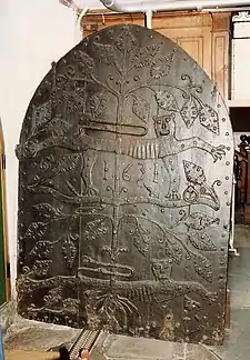 Church of St Saviour |
| The Butterwalk, 6, Duke St | Dartmouth, South Hams | Apartment | 1949 | 14 September 1949 | SX8778851411 50°21′07″N 3°34′43″W |
1197516 |  The Butterwalk, 6, Duke St |
| The Butterwalk, 8, Duke St | Dartmouth, South Hams | Apartment | 1949 | 14 September 1949 | SX8778351408 50°21′07″N 3°34′43″W |
1197517 | 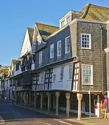 The Butterwalk, 8, Duke St |
| The Butterwalk, 10, Duke St | Dartmouth, South Hams | Apartment | 1949 | 14 September 1949 | SX8777551407 50°21′07″N 3°34′44″W |
1197518 | 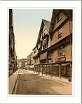 The Butterwalk, 10, Duke St |
| The Butterwalk, 12 Duke St | Dartmouth, South Hams | Apartment | 1949 | 14 September 1949 | SX8776951406 50°21′07″N 3°34′44″W |
1197519 | .jpg.webp) The Butterwalk, 12 Duke St |
| Walls of the Ruined Fortalice | Dartmouth Castle, Dartmouth, South Hams | Tower | Late 14th century | 11 December 1969 | SX8863050277 50°20′31″N 3°33′59″W |
1197566 | 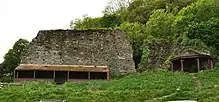 Walls of the Ruined Fortalice |
| Church of St George | Dean Prior, South Hams | Parish Church | Circa 13th century or early 14th century | 9 February 1961 | SX7302163543 50°27′29″N 3°47′25″W |
1308741 | 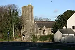 Church of St George |
| Church of St Mary | Diptford, South Hams | Parish Church | 13th century | 9 February 1961 | SX7273656768 50°23′49″N 3°47′31″W |
1211482 | 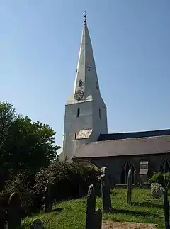 Church of St Mary |
| Church of St George | Dittisham, South Hams | Parish Church | originally 1050 | 9 February 1961 | SX8611755073 50°23′04″N 3°36′12″W |
1108270 |  Church of St George |
| Church of St Peter and St Paul | Ermington, South Hams | Church | 15th century | 29 March 1960 | SX6383553219 50°21′47″N 3°54′57″W |
1308362 |  Church of St Peter and St Paul |
| Church of St Martin | Sherford, Frogmore and Sherford, South Hams | Parish Church | 14th century | 26 January 1967 | SX7789944246 50°17′08″N 3°42′55″W |
1169223 | 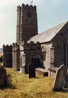 Church of St Martin |
| Church of All Saints including Fishacre Tomb adjoining Transept (formerly listed under Parish of Moreleigh) | Moreleigh, Halwell and Moreleigh, South Hams | Church | 13th century | 9 February 1961 | SX7612752585 50°21′36″N 3°44′34″W |
1108278 | 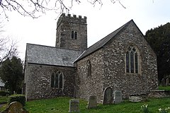 Church of All Saints including Fishacre Tomb adjoining Transept (formerly listed under Parish of Moreleigh) |
| Church of St Leonard | Halwell, Halwell and Moreleigh, South Hams | Parish Church | possibly after 1288 | 9 February 1961 | SX7773353204 50°21′58″N 3°43′14″W |
1108275 | 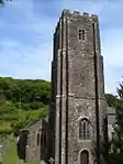 Church of St Leonard |
| Church of St Andrew | Harberton, South Hams | Church | 12th century site of | 9 February 1961 | SX7782958637 50°24′53″N 3°43′15″W |
1108222 | 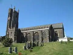 Church of St Andrew |
| Church of St Petroc | Harford, South Hams | Parish Church | Circa late 15th century to early 16th century | 23 March 1960 | SX6383159471 50°25′09″N 3°55′05″W |
1162617 | 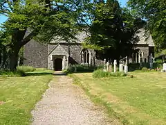 Church of St Petroc |
| Church of All Saints | Holbeton, South Hams | Church | Late 19th century | 29 March 1960 | SX6130050183 50°20′07″N 3°57′01″W |
1107808 |  Church of All Saints |
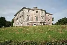
| Flete | Holbeton, South Hams | Country House | 16th century | 29 March 1960 | SX6278251382 50°20′47″N 3°55′48″W |
1107820 | 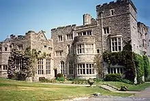 Flete |
| Gate Piers, Gates, Walls and Terraces Immediately North and East of Flete | Holbeton, South Hams | Terrace | 1878 | 19 July 1984 | SX6280451417 50°20′48″N 3°55′47″W |
1107777 | |
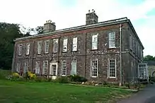
| Mothecombe House | Mothecombe, Holbeton, South Hams | Country House | c. 1710 | 29 March 1960 | SX6086047813 50°18′50″N 3°57′20″W |
1168279 | 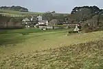 Mothecombe House |
| Church of St Mary the Virgin | Holne, South Hams | Parish Church | c. 1300 | 9 February 1961 | SX7058069488 50°30′39″N 3°49′36″W |
1107379 | 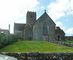 Church of St Mary the Virgin |
| Church of St Edmund | Kingsbridge, South Hams | Church | 1414 | 13 December 1949 | SX7341444401 50°17′09″N 3°46′42″W |
1165559 | 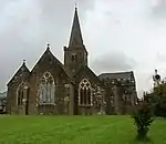 Church of St Edmund |
| Church of St Thomas a Becket | Dodbrooke, Kingsbridge, South Hams | Church | 15th century | 13 December 1949 | SX7393644518 50°17′14″N 3°46′15″W |
1317351 | 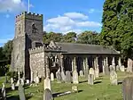 Church of St Thomas a Becket |
| Kingswear Castle | Kingswear, South Hams | Castle | By mid 17th century abandoned | 8 October 1949 | SX8910150282 50°20′31″N 3°33′35″W |
1108543 | |
| Church of St John the Baptist | Littlehempston, South Hams | Church | 14th century | 9 February 1961 | SX8124562633 50°27′05″N 3°40′27″W |
1108513 |  Church of St John the Baptist |
| The Old Manor Including Barn Adjoining South and Courtyard Walls Attached to South East | Littlehempston, South Hams | House | 1952 | 11 February 1952 | SX8079763280 50°27′26″N 3°40′50″W |
1108511 | |
| Church of All Saints | Malborough, South Hams | Parish Church | 13th century | 26 January 1967 | SX7068539815 50°14′39″N 3°48′54″W |
1108485 | 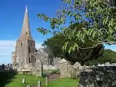 Church of All Saints |
| Yarde Farmhouse | Malborough, South Hams | Farmhouse | Second half of the 17th century | 26 January 1967 | SX7167940056 50°14′47″N 3°48′04″W |
1108479 | |
| Church of St John the Baptist | Marldon, South Hams | Parish Church | c. 1400 | 9 February 1961 | SX8662463576 50°27′40″N 3°35′55″W |
1308643 | 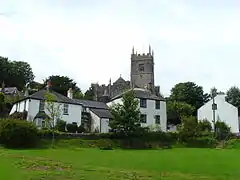 Church of St John the Baptist |
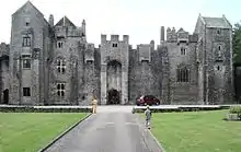
| Compton Castle | Compton, Marldon, South Hams | Castle | Early 14th century | 11 November 1952 | SX8653764839 50°28′20″N 3°36′01″W |
1324886 | |
| Church of St George | Modbury, South Hams | Anglican Church | 1621 | 26 January 1967 | SX6559951549 50°20′55″N 3°53′25″W |
1108059 | 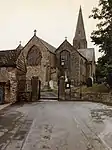 Church of St George |
| Church of Holy Cross | Newton Ferrers, Newton and Noss, South Hams | Parish Church | C13/14 | 29 March 1960 | SX5501548153 50°18′56″N 4°02′16″W |
1325256 | |
| Church of St Peter the Poor Fisherman | Revelstoke, Newton and Noss, South Hams | Church | circa 13th century | 19 July 1984 | SX5639446437 50°18′01″N 4°01′04″W |
1107794 | |
| Puslinch House | Puslinch, Newton and Noss, South Hams | Country House | c. 1720 | 29 March 1960 | SX5695050893 50°20′26″N 4°00′42″W |
1168866 |  Puslinch House |
| Church of St Mary | North Huish, South Hams | Church | 14th century | 9 February 1961 | SX7113056548 50°23′41″N 3°48′52″W |
1108208 | |
| Church of St Mary | Rattery, South Hams | Parish Church | 13th century | 9 February 1961 | SX7407061551 50°26′25″N 3°46′29″W |
1147626 | 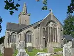 Church of St Mary |
| Church of St Edward | Shaugh Prior, South Hams | Parish Church | 15th century | 29 March 1960 | SX5428063112 50°26′59″N 4°03′14″W |
1162816 | 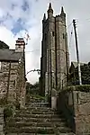 Church of St Edward |
| Church of St James | Slapton, South Hams | Parish Church | 13th century | 26 January 1967 | SX8213144990 50°17′35″N 3°39′22″W |
1164002 |  Church of St James |
| Tower of Collegiate Chantry of St Mary | Slapton, South Hams | Bell Tower | 1372 OR 3 | 26 January 1967 | SX8216345061 50°17′37″N 3°39′20″W |
1317950 | 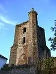 Tower of Collegiate Chantry of St Mary |
| Church of St Petrock | South Brent, South Hams | Parish Church | Circa 12th century | 9 February 1961 | SX6961960257 50°25′40″N 3°50′13″W |
1147794 | 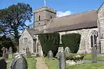 Church of St Petrock |
| Church of All Saints | South Milton, South Hams | Parish Church | 12th century | 26 January 1967 | SX6980142898 50°16′18″N 3°49′42″W |
1108433 | 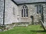 Church of All Saints |
| Church of St Nicholas and St Cyriac | South Pool, South Hams | Parish Church | Early 14th century | 26 January 1967 | SX7763140377 50°15′02″N 3°43′04″W |
1324926 |  Church of St Nicholas and St Cyriac |
| Old Newnham | Sparkwell, South Hams | Manor House | 15th century | 23 April 1952 | SX5521257331 50°23′53″N 4°02′19″W |
1162879 | |
| Church of St Paul | Staverton, South Hams | Parish Church | circa early 14th century | 9 February 1961 | SX7938463909 50°27′45″N 3°42′03″W |
1108524 |  Church of St Paul |
| Staverton Bridge | Staverton, South Hams | Road Bridge | 1413 | 9 February 1961 | SX7846363724 50°27′39″N 3°42′49″W |
1324890 | 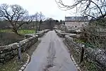 Staverton Bridge |
| Staverton Bridge | Staverton, South Hams | Road Bridge | 1413 | 9 February 1961 | SX7846863720 50°27′38″N 3°42′49″W |
1324955 | Staverton Bridge |
| Church of St Gabriel and St Mary | Stoke Gabriel, South Hams | Parish Church | 13th century | 9 February 1961 | SX8491657135 50°24′10″N 3°37′15″W |
1108497 |  Church of St Gabriel and St Mary |
| Church of St Michael | Stokenham, South Hams | Parish Church | 14th century | 26 January 1967 | SX8083942828 50°16′24″N 3°40′25″W |
1107972 | 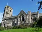 Church of St Michael |
| Bowden House | Ashprington, near Totnes, South Hams | Manor House | c. 1509 | 7 January 1952 | SX8014358848 50°25′02″N 3°41′18″W |
1236034 | |
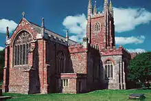
| Church of St Mary | Totnes, South Hams | Church | before 1432 | 7 January 1952 | SX8021960473 50°25′55″N 3°41′16″W |
1236065 | |
| Eastgate (part of No 2 High Street) | Totnes, South Hams | Gate | 14th century | 7 January 1952 | SX8027660426 50°25′53″N 3°41′13″W |
1236272 | |
| Elizabethan House and Local Museum | Totnes, South Hams | Kitchen | late 16th century or early 17th century | 7 January 1952 | SX8030460410 50°25′53″N 3°41′12″W |
1235946 | |
| Totnes Castle | Totnes, South Hams | Motte and Bailey | shortly after Conquest | 14 November 1969 | SX8002760505 50°25′56″N 3°41′26″W |
1168856 | |
| Totnes Guildhall | Totnes, South Hams | Guildhall | c. 1553 | 7 January 1952 | SX8022660502 50°25′56″N 3°41′16″W |
1235949 | |
| 43 Butterwalk and 43 High Street | Totnes, South Hams | House | 14th century or early 15th century | 7 January 1952 | SX8011360462 50°25′54″N 3°41′22″W |
1264728 |  43 Butterwalk and 43 High Street |
| Church of St Peter | Ugborough, South Hams | Parish Church | Early 14th century | 9 February 1961 | SX6774855719 50°23′11″N 3°51′42″W |
1168309 |  Church of St Peter |
| Church of St Werburgh | Wembury, South Hams | Parish Church | 14th century | 29 March 1960 | SX5184448501 50°19′04″N 4°04′57″W |
1169151 | 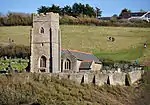 Church of St Werburgh |
| Bowringsleigh | West Alvington, South Hams | Country House | 15th century | 25 October 1951 | SX7176944422 50°17′09″N 3°48′05″W |
1170092 | |
| Church of All Saints | West Alvington, South Hams | Parish Church | 13th century | 26 January 1967 | SX7239143876 50°16′52″N 3°47′33″W |
1108423 | 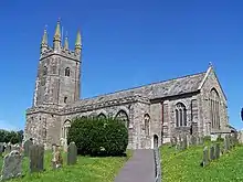 Church of All Saints |
| Kitley House | Yealmpton, South Hams | Country House | 1710 | 23 April 1952 | SX5596951462 50°20′43″N 4°01′32″W |
1306538 |  Kitley House |
| Lyneham House | Lyneham, Yealmpton, South Hams | Country House | circa 1699 to 1703 | 23 April 1952 | SX5788053454 50°21′50″N 3°59′58″W |
1169295 | 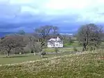 Lyneham House |


Notes
- The date given is the date used by Historic England as significant for the initial building or that of an important part in the structure's description.
- Sometimes known as OSGB36, the grid reference is based on the British national grid reference system used by the Ordnance Survey.
- The "List Entry Number" is a unique number assigned to each listed building and scheduled monument by Historic England.
External links
This article is issued from Wikipedia. The text is licensed under Creative Commons - Attribution - Sharealike. Additional terms may apply for the media files.