National Register of Historic Places listings in Otero County, Colorado
This is a list of the National Register of Historic Places listings in Otero County, Colorado.
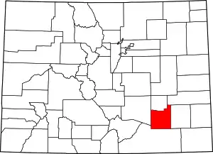
Location of Otero County in Colorado
This is intended to be a complete list of the properties and districts on the National Register of Historic Places in Otero County, Colorado, United States. The locations of National Register properties and districts for which the latitude and longitude coordinates are included below, may be seen in a map.[1]
There are 18 properties and districts listed on the National Register in the county, including 1 National Historic Landmark.
- This National Park Service list is complete through NPS recent listings posted February 5, 2021.[2]
| Adams - Alamosa - Arapahoe - Archuleta - Baca - Bent - Boulder - Broomfield - Chaffee - Cheyenne - Clear Creek - Conejos - Costilla - Crowley - Custer - Delta - Denver - Dolores - Douglas - Eagle - El Paso - Elbert - Fremont - Garfield - Gilpin - Grand - Gunnison - Hinsdale - Huerfano - Jackson - Jefferson - Kiowa - Kit Carson - La Plata - Lake - Larimer - Las Animas - Lincoln - Logan - Mesa - Mineral - Moffat - Montezuma - Montrose - Morgan - Otero - Ouray - Park - Phillips - Pitkin - Prowers - Pueblo - Rio Blanco - Rio Grande - Routt - Saguache - San Juan - San Miguel - Sedgwick - Summit - Teller - Washington - Weld - Yuma |
Current listings
| [3] | Name on the Register[4] | Image | Date listed[5] | Location | City or town | Description |
|---|---|---|---|---|---|---|
| 1 | Adobe Stables, Arkansas Valley Fairgrounds | Adobe Stables, Arkansas Valley Fairgrounds |
December 26, 2007 (#07001305) |
800 N. 9th St. 38°03′35″N 103°42′57″W |
Rocky Ford | |
| 2 | Art Building | 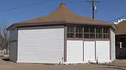 Art Building |
September 27, 1996 (#96001027) |
Arkansas Valley Fairgrounds, near the junction of Main St. and U.S. Highway 50 38°03′31″N 103°43′07″W |
Rocky Ford | |
| 3 | Bent's Old Fort National Historic Site | 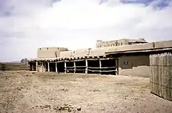 Bent's Old Fort National Historic Site |
October 15, 1966 (#66000254) |
State Highway 194 38°02′37″N 103°25′53″W |
La Junta | |
| 4 | Carnegie Public Library | 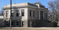 Carnegie Public Library |
November 7, 1995 (#95001247) |
1005 Sycamore Ave. 38°02′59″N 103°43′09″W |
Rocky Ford | |
| 5 | Dr. Frank Finney House | _from_NE_1.JPG.webp) Dr. Frank Finney House |
May 17, 1984 (#84000877) |
608 Belleview Ave. 37°58′57″N 103°32′51″W |
La Junta | |
| 6 | Wilson A. Hart House | _from_E_1.JPG.webp) Wilson A. Hart House |
May 31, 1979 (#79000617) |
802 Raton Ave. 37°58′51″N 103°32′31″W |
La Junta | |
| 7 | La Junta City Park | 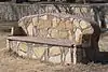 La Junta City Park |
April 24, 2007 (#07000343) |
Bounded by Colorado and Park Aves. and 10th and 14th Sts. 37°58′38″N 103°32′39″W |
La Junta | |
| 8 | Lincoln School | Lincoln School |
September 13, 1978 (#78000874) |
300 block of W. 3rd St. 37°59′10″N 103°32′53″W |
La Junta | |
| 9 | North La Junta School | 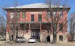 North La Junta School |
June 25, 1992 (#92000809) |
Junction of State Highways 109 and 194 38°00′02″N 103°31′51″W |
La Junta | |
| 10 | Rocky Ford Post Office | 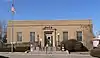 Rocky Ford Post Office |
January 16, 2008 (#07001394) |
401 N. 9th St.[6] 38°03′19″N 103°43′13″W |
Rocky Ford | |
| 11 | Eugene Rourke House | _from_SW_1.JPG.webp) Eugene Rourke House |
May 9, 1983 (#83001326) |
619 Carson St. 37°58′56″N 103°32′53″W |
La Junta | |
| 12 | San Juan Avenue Historic District | 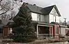 San Juan Avenue Historic District |
August 27, 1980 (#80000918) |
501–521 and 522 San Juan Ave.[6] 37°59′00″N 103°32′45″W |
La Junta | |
| 13 | Santa Fe Railway Manzanola Depot | 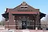 Santa Fe Railway Manzanola Depot |
April 28, 2004 (#04000363) |
212 N. Grand Ave. 38°06′35″N 103°52′00″W |
Manzanola | |
| 14 | Santa Fe Trail Mountain Route Trail Segments-Bloom Vicinity | February 23, 2016 (#16000025) |
Address Restricted |
Bloom vicinity | ||
| 15 | Santa Fe Trail Mountain Route Trail Segments-Iron Springs Vicinity | .jpg.webp) Santa Fe Trail Mountain Route Trail Segments-Iron Springs Vicinity |
August 28, 2017 (#100000682) |
Address Restricted |
Mindeman vicinity | |
| 16 | Santa Fe Trail Mountain Route Trail Segments-Timpas Vicinity | February 23, 2016 (#16000026) |
Address Restricted |
Timpas vicinity | ||
| 17 | Daniel Sciumbato Grocery Store | _from_NE_1.JPG.webp) Daniel Sciumbato Grocery Store |
May 17, 1984 (#84000878) |
706 2nd St. 37°59′12″N 103°33′06″W |
La Junta | |
| 18 | U.S. Post Office | 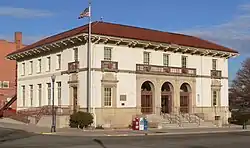 U.S. Post Office |
July 12, 1976 (#76000565) |
4th and Colorado Ave. 37°59′07″N 103°32′36″W |
La Junta |
See also
| Wikimedia Commons has media related to National Register of Historic Places in Otero County, Colorado. |
References
- The latitude and longitude information provided in this table was derived originally from the National Register Information System, which has been found to be fairly accurate for about 99% of listings. Some locations in this table may have been corrected to current GPS standards.
- "National Register of Historic Places: Weekly List Actions". National Park Service, United States Department of the Interior. Retrieved on February 5, 2021.
- Numbers represent an alphabetical ordering by significant words. Various colorings, defined here, differentiate National Historic Landmarks and historic districts from other NRHP buildings, structures, sites or objects.
- "National Register Information System". National Register of Historic Places. National Park Service. July 9, 2010.
- The eight-digit number below each date is the number assigned to each location in the National Register Information System database, which can be viewed by clicking the number.
- "Otero County". History Colorado. Retrieved 2012-02-20.
| Topics | |
|---|---|
| Lists by state |
|
| Lists by insular areas | |
| Lists by associated state | |
| Other areas | |
| Related | |
| |
Municipalities and communities of Otero County, Colorado, United States | ||
|---|---|---|
| Cities | Map of Colorado highlighting Otero County | |
| Towns | ||
| CDPs | ||
| Unincorporated communities | ||
| Ghost town | ||
| ||
This article is issued from Wikipedia. The text is licensed under Creative Commons - Attribution - Sharealike. Additional terms may apply for the media files.