National Register of Historic Places listings in Alamosa County, Colorado
This is a list of the National Register of Historic Places listings in Alamosa County, Colorado.
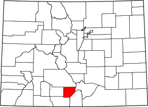
Location of Alamosa County in Colorado
This is intended to be a complete list of the properties and districts on the National Register of Historic Places in Alamosa County, Colorado, United States. The locations of National Register properties and districts for which the latitude and longitude coordinates are included below, may be seen in a map.[1]
There are 15 properties and districts listed on the National Register in the county.
- This National Park Service list is complete through NPS recent listings posted January 29, 2021.[2]
| Adams - Alamosa - Arapahoe - Archuleta - Baca - Bent - Boulder - Broomfield - Chaffee - Cheyenne - Clear Creek - Conejos - Costilla - Crowley - Custer - Delta - Denver - Dolores - Douglas - Eagle - El Paso - Elbert - Fremont - Garfield - Gilpin - Grand - Gunnison - Hinsdale - Huerfano - Jackson - Jefferson - Kiowa - Kit Carson - La Plata - Lake - Larimer - Las Animas - Lincoln - Logan - Mesa - Mineral - Moffat - Montezuma - Montrose - Morgan - Otero - Ouray - Park - Phillips - Pitkin - Prowers - Pueblo - Rio Blanco - Rio Grande - Routt - Saguache - San Juan - San Miguel - Sedgwick - Summit - Teller - Washington - Weld - Yuma |
Current listings
| [3] | Name on the Register[4] | Image | Date listed[5] | Location | City or town | Description |
|---|---|---|---|---|---|---|
| 1 | Alamosa County Courthouse | Alamosa County Courthouse |
September 29, 1995 (#95001149) |
702 4th St. 37°28′08″N 105°52′02″W |
Alamosa | |
| 2 | Alamosa Post Office | Alamosa Post Office |
July 22, 2009 (#09000544) |
703 4th St. 37°28′09″N 105°52′02″W |
Alamosa | |
| 3 | American National Bank Building | 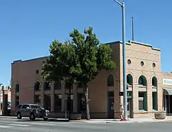 American National Bank Building |
April 15, 1999 (#99000446) |
500 State Ave. 37°28′05″N 105°51′53″W |
Alamosa | |
| 4 | Denver and Rio Grande Railroad Depot | Denver and Rio Grande Railroad Depot |
February 11, 1993 (#93000034) |
610 State St. 37°28′00″N 105°51′53″W |
Alamosa | |
| 5 | Denver and Rio Grande Railroad Locomotive No.169 | 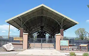 Denver and Rio Grande Railroad Locomotive No.169 |
March 12, 2001 (#01000230) |
Along Chamber Dr. within Cole Park 37°28′10″N 105°51′45″W |
Alamosa | |
| 6 | First Baptist Church | .JPG.webp) First Baptist Church |
May 22, 2005 (#05000425) |
408 State Ave. 37°28′08″N 105°51′53″W |
Alamosa | |
| 7 | Howard Store | 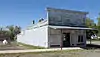 Howard Store |
February 1, 2006 (#05001597) |
8681 Main St. 37°44′47″N 105°52′37″W |
Hooper | |
| 8 | Husung Hardware | 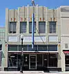 Husung Hardware |
January 28, 2000 (#00000003) |
625 Main St. 37°28′06″N 105°51′57″W |
Alamosa | |
| 9 | Medano Ranch Headquarters | 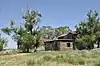 Medano Ranch Headquarters |
February 4, 2004 (#03001543) |
2.6 miles north of County Road 6N, Medano-Zapata Ranch 37°42′52″N 105°40′55″W |
Mosca | A Nature Conservancy-owned historic ranch property located within Great Sand Dunes National Park; access is limited. |
| 10 | Mt. Pleasant School | 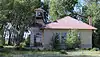 Mt. Pleasant School |
May 3, 2006 (#06000327) |
Junction of County Roads 3, S. and 103, S. 37°31′52″N 105°59′01″W |
Alamosa | |
| 11 | Sacred Heart Catholic Church | .JPG.webp) Sacred Heart Catholic Church |
July 15, 1998 (#98000855) |
727 4th St. 37°28′11″N 105°52′04″W |
Alamosa | |
| 12 | St. Thomas Episcopal Church | St. Thomas Episcopal Church |
April 22, 2003 (#03000285) |
607 4th St. 37°28′10″N 105°51′57″W |
Alamosa | |
| 13 | Superintendent's Residence, Great Sand Dunes National Monument | 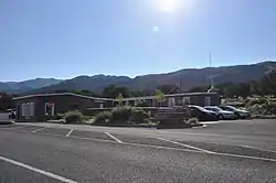 Superintendent's Residence, Great Sand Dunes National Monument |
November 2, 1989 (#89001761) |
State Highway 150 southwest of Mosca 37°43′30″N 105°31′05″W |
Mosca | At the entrance gate to the Great Sand Dunes National Park. |
| 14 | Trujillo Homestead | 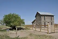 Trujillo Homestead |
February 4, 2004 (#03001544) |
Medano-Zapata Ranch 37°44′00″N 105°44′09″W |
Mosca | On Nature Conservancy land in or near the Great Sand Dunes National Park; access is limited. |
| 15 | Zapata Ranch Headquarters | 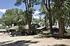 Zapata Ranch Headquarters |
April 5, 1993 (#93000199) |
5303 State Highway 150 37°39′10″N 105°35′33″W |
Mosca | A Nature Conservancy-owned historic ranch property located near the Great Sand Dunes National Park. |
See also
| Wikimedia Commons has media related to National Register of Historic Places in Alamosa County, Colorado. |
References
- The latitude and longitude information provided in this table was derived originally from the National Register Information System, which has been found to be fairly accurate for about 99% of listings. Some locations in this table may have been corrected to current GPS standards.
- "National Register of Historic Places: Weekly List Actions". National Park Service, United States Department of the Interior. Retrieved on January 29, 2021.
- Numbers represent an alphabetical ordering by significant words. Various colorings, defined here, differentiate National Historic Landmarks and historic districts from other NRHP buildings, structures, sites or objects.
- "National Register Information System". National Register of Historic Places. National Park Service. July 9, 2010.
- The eight-digit number below each date is the number assigned to each location in the National Register Information System database, which can be viewed by clicking the number.
| Topics | |
|---|---|
| Lists by state |
|
| Lists by insular areas | |
| Lists by associated state | |
| Other areas | |
| Related | |
| |
Municipalities and communities of Alamosa County, Colorado, United States | ||
|---|---|---|
| City | Map of Colorado highlighting Alamosa County | |
| Town | ||
| CDP | ||
| Unincorporated communities | ||
| Footnotes | ‡This populated place also has portions in an adjacent county or counties | |
| ||
This article is issued from Wikipedia. The text is licensed under Creative Commons - Attribution - Sharealike. Additional terms may apply for the media files.