National Register of Historic Places listings in Logan County, Colorado
This is a list of the National Register of Historic Places listings in Logan County, Colorado.
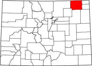
Location of Logan County in Colorado
This is intended to be a complete list of the properties and districts on the National Register of Historic Places in Logan County, Colorado, United States. The locations of National Register properties and districts for which the latitude and longitude coordinates are included below, may be seen in a map.[1]
There are 12 properties and districts listed on the National Register in the county.
- This National Park Service list is complete through NPS recent listings posted February 5, 2021.[2]
| Adams - Alamosa - Arapahoe - Archuleta - Baca - Bent - Boulder - Broomfield - Chaffee - Cheyenne - Clear Creek - Conejos - Costilla - Crowley - Custer - Delta - Denver - Dolores - Douglas - Eagle - El Paso - Elbert - Fremont - Garfield - Gilpin - Grand - Gunnison - Hinsdale - Huerfano - Jackson - Jefferson - Kiowa - Kit Carson - La Plata - Lake - Larimer - Las Animas - Lincoln - Logan - Mesa - Mineral - Moffat - Montezuma - Montrose - Morgan - Otero - Ouray - Park - Phillips - Pitkin - Prowers - Pueblo - Rio Blanco - Rio Grande - Routt - Saguache - San Juan - San Miguel - Sedgwick - Summit - Teller - Washington - Weld - Yuma |
Current listings
| [3] | Name on the Register[4] | Image | Date listed[5] | Location | City or town | Description |
|---|---|---|---|---|---|---|
| 1 | Downtown Sterling Historic District | 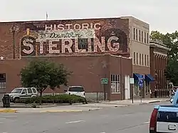 Downtown Sterling Historic District |
August 13, 2013 (#13000592) |
Bounded by Division Ave., Poplar, Front, Ash and 4th Sts. 40°37′26″N 103°12′36″W |
Sterling | |
| 2 | First United Presbyterian Church | 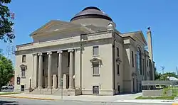 First United Presbyterian Church |
June 3, 1982 (#82002304) |
130 S. 4th St. 40°37′25″N 103°12′37″W |
Sterling | |
| 3 | W.C. Harris House | 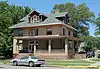 W.C. Harris House |
May 17, 1984 (#84000864) |
102 Taylor St. 40°37′08″N 103°12′38″W |
Sterling | |
| 4 | I and M Building | I and M Building |
June 3, 1982 (#82002305) |
223 Main St. 40°37′25″N 103°12′28″W |
Sterling | |
| 5 | Logan County Courthouse | 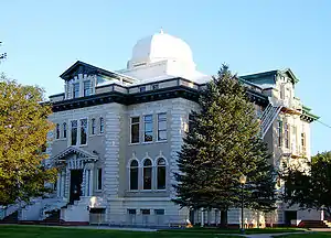 Logan County Courthouse |
February 28, 1979 (#79000615) |
Main St. 40°37′25″N 103°12′32″W |
Sterling | |
| 6 | Conrad Luft Sr. House | 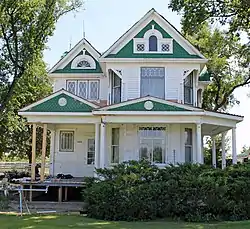 Conrad Luft Sr. House |
May 17, 1984 (#84000866) |
1429 State Highway 14 40°37′29″N 103°14′03″W |
Sterling | Queen Anne-style house which was moved in 1925 |
| 7 | Pantall Elementary School |  Pantall Elementary School |
July 14, 2015 (#15000409) |
1215 N. 5th St. 40°38′15″N 103°12′21″W |
Sterling | Now called Stevens School. |
| 8 | Powell and Blair Stone Ranch | April 6, 2004 (#04000261) |
Approximately 1 mile north of the junction of U.S. Route 138 and 65 Rd. 40°48′55″N 102°57′03″W |
Proctor | ||
| 9 | St. Anthony's Roman Catholic Church | 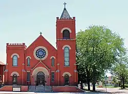 St. Anthony's Roman Catholic Church |
June 3, 1982 (#82002306) |
329 S. 3rd St. 40°37′14″N 103°12′36″W |
Sterling | |
| 10 | Sterling Public Library | .JPG.webp) Sterling Public Library |
October 20, 2001 (#01001121) |
210 S. 4th St. 40°37′23″N 103°12′38″W |
Sterling | |
| 11 | Sterling Union Pacific Railroad Depot | 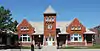 Sterling Union Pacific Railroad Depot |
February 6, 1986 (#86000210) |
113 N. Front St. 40°37′29″N 103°12′15″W |
Sterling | |
| 12 | US Post Office, Federal Building, and Federal Courthouse-Sterling Main | 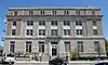 US Post Office, Federal Building, and Federal Courthouse-Sterling Main |
January 22, 1986 (#86000187) |
3rd and Popular Sts. 40°37′29″N 103°12′27″W |
Sterling |
See also
| Wikimedia Commons has media related to National Register of Historic Places in Logan County, Colorado. |
References
- The latitude and longitude information provided in this table was derived originally from the National Register Information System, which has been found to be fairly accurate for about 99% of listings. Some locations in this table may have been corrected to current GPS standards.
- "National Register of Historic Places: Weekly List Actions". National Park Service, United States Department of the Interior. Retrieved on February 5, 2021.
- Numbers represent an alphabetical ordering by significant words. Various colorings, defined here, differentiate National Historic Landmarks and historic districts from other NRHP buildings, structures, sites or objects.
- "National Register Information System". National Register of Historic Places. National Park Service. July 9, 2010.
- The eight-digit number below each date is the number assigned to each location in the National Register Information System database, which can be viewed by clicking the number.
| Topics | |
|---|---|
| Lists by state |
|
| Lists by insular areas | |
| Lists by associated state | |
| Other areas | |
| Related | |
| |
Municipalities and communities of Logan County, Colorado, United States | ||
|---|---|---|
| City | Map of Colorado highlighting Logan County | |
| Towns | ||
| CDPs | ||
| Unincorporated communities |
| |
| ||
This article is issued from Wikipedia. The text is licensed under Creative Commons - Attribution - Sharealike. Additional terms may apply for the media files.