National Register of Historic Places listings in Montezuma County, Colorado
This is a list of the National Register of Historic Places listings in Montezuma County, Colorado.
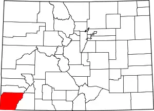
Location of Montezuma County in Colorado
This is intended to be a complete list of the properties and districts on the National Register of Historic Places in Montezuma County, Colorado, United States. The locations of National Register properties and districts for which the latitude and longitude coordinates are included below, may be seen in an online map.[1]
There are 36 properties and districts listed on the National Register in the county, including 2 National Historic Landmarks.
- This National Park Service list is complete through NPS recent listings posted February 5, 2021.[2]
| Adams - Alamosa - Arapahoe - Archuleta - Baca - Bent - Boulder - Broomfield - Chaffee - Cheyenne - Clear Creek - Conejos - Costilla - Crowley - Custer - Delta - Denver - Dolores - Douglas - Eagle - El Paso - Elbert - Fremont - Garfield - Gilpin - Grand - Gunnison - Hinsdale - Huerfano - Jackson - Jefferson - Kiowa - Kit Carson - La Plata - Lake - Larimer - Las Animas - Lincoln - Logan - Mesa - Mineral - Moffat - Montezuma - Montrose - Morgan - Otero - Ouray - Park - Phillips - Pitkin - Prowers - Pueblo - Rio Blanco - Rio Grande - Routt - Saguache - San Juan - San Miguel - Sedgwick - Summit - Teller - Washington - Weld - Yuma |
Current listings
| [3] | Name on the Register[4] | Image | Date listed[5] | Location | City or town | Description |
|---|---|---|---|---|---|---|
| 1 | Albert Porter Pueblo | March 18, 1999 (#99000266) |
Address Restricted |
Yellow Jacket | ||
| 2 | Anasazi Archeological District | July 19, 1984 (#84001273) |
Address Restricted |
Dolores | ||
| 3 | Archeological Site no. 5MT4700 | June 11, 1999 (#99000685) |
Address Restricted |
Yellow Jacket | ||
| 4 | Bass Site | June 11, 1999 (#99000654) |
Address Restricted |
Yellow Jacket | ||
| 5 | Bauer Bank Block | 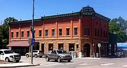 Bauer Bank Block |
October 11, 2003 (#03001009) |
107 W. Grand Ave. 37°20′42″N 108°17′20″W |
Mancos | |
| 6 | Cannonball Ruins | 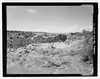 Cannonball Ruins |
April 30, 1997 (#97000378) |
Address Restricted |
Cortez | |
| 7 | Cortez High School | 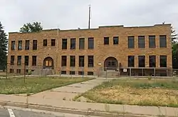 Cortez High School |
March 22, 2016 (#16000098) |
121 E. First St. 37°20′50″N 108°34′59″W |
Cortez | Cortez' old high school, most recently Calkins Jr. High School. |
| 8 | Ertel Funeral Home | 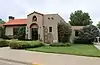 Ertel Funeral Home |
November 7, 1995 (#95001248) |
42 N. Market St. 37°20′58″N 108°35′03″W |
Cortez | |
| 9 | Escalante Ruin | Escalante Ruin |
November 20, 1975 (#75000527) |
Address Restricted 37°28′40″N 108°32′44″W |
Dolores | |
| 10 | Haynie Site | November 13, 2017 (#100001792) |
29619 Cty. Rd. L 37°22′41″N 108°30′15″W |
Mancos vicinity | ||
| 11 | Hovenweep National Monument | 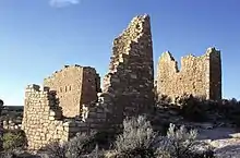 Hovenweep National Monument |
October 15, 1966 (#66000250) |
Northwest of Cortez 37°26′35″N 108°58′56″W |
Cortez | |
| 12 | Indian Camp Ranch Archeological District | March 28, 2012 (#12000145) |
Address Restricted |
Cortez vicinity | ||
| 13 | Joe Ben Wheat Site Complex | January 16, 2004 (#03001383) |
Address Restricted |
Yellow Jacket | ||
| 14 | James A. Lancaster Site | April 14, 1980 (#80000914) |
Address Restricted |
Pleasant View | ||
| 15 | Lebanon School | 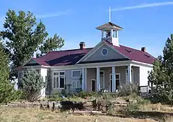 Lebanon School |
May 29, 1996 (#96000543) |
24925 County Road T 37°27′28″N 108°35′29″W |
Dolores | |
| 16 | Lost Canyon Archeological District | October 18, 1988 (#88001909) |
Address Restricted |
Mancos | ||
| 17 | Lowry Ruin | 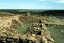 Lowry Ruin |
October 15, 1966 (#66000253) |
30 miles (48 km) northwest of Cortez via U.S. Route 160 37°35′04″N 108°55′11″W |
Pleasant View | |
| 18 | Mancos High School | 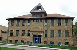 Mancos High School |
December 23, 1991 (#91001740) |
350 Grand Ave. 37°20′44″N 108°17′32″W |
Mancos | |
| 19 | Mancos Opera House | 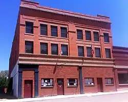 Mancos Opera House |
January 7, 1988 (#87002183) |
136 W. Grand Ave. 37°20′11″N 108°17′23″W |
Mancos | |
| 20 | Mesa Verde Administrative District |  Mesa Verde Administrative District |
May 28, 1987 (#87001410) |
Area at head of Spruce Canyon off park service road 37°11′03″N 108°29′18″W |
Mesa Verde National Park | |
| 21 | Mesa Verde National Park | 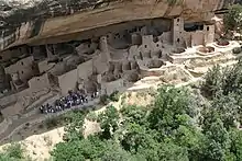 Mesa Verde National Park |
October 15, 1966 (#66000251) |
10 miles (16 km) east of Cortez on U.S. Route 160 37°14′52″N 108°27′06″W |
Cortez | |
| 22 | Mitchell Springs Archeological Site | November 9, 2001 (#01001207) |
7755 Road 25 37°19′30″N 108°35′44″W |
Cortez | ||
| 23 | Montezuma Valley Irrigation Company Flume No. 6 | 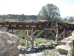 Montezuma Valley Irrigation Company Flume No. 6 |
March 27, 2012 (#12000146) |
Approximately 4 miles (6.4 km) east of Cortez on US 160 37°20′52″N 108°30′10″W |
Cortez vicinity | |
| 24 | Montezuma Valley National Bank and Store Building | 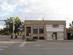 Montezuma Valley National Bank and Store Building |
January 15, 2009 (#08001317) |
2-8 Main St. 37°20′55″N 108°35′06″W |
Cortez | |
| 25 | Mud Springs Pueblo | October 29, 1982 (#82001020) |
Address Restricted |
Cortez | ||
| 26 | Painted Hand Pueblo | May 8, 2014 (#13000576) |
Address Restricted |
Pleasant View | ||
| 27 | Pigge Site | April 7, 1980 (#80000915) |
Address Restricted |
Pleasant View | ||
| 28 | Roy's Ruin | January 31, 1992 (#91002027) |
Address Restricted |
Cortez | ||
| 29 | Sand Canyon Archaeological District | Sand Canyon Archaeological District |
March 15, 2005 (#05000138) |
Address Restricted |
Cortez | |
| 30 | Seven Towers Pueblo | June 11, 1999 (#99000653) |
Address Restricted |
Yellow Jacket | ||
| 31 | Southern Hotel | Southern Hotel |
February 23, 1989 (#89000018) |
101 S. 5th St. 37°28′35″N 108°30′09″W |
Dolores | |
| 32 | Ute Mountain Ute Mancos Canyon Historic District | 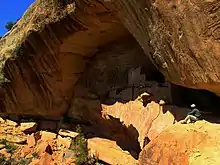 Ute Mountain Ute Mancos Canyon Historic District |
May 2, 1972 (#72000273) |
Address Restricted |
Durango | |
| 33 | Woods Canyon Pueblo | June 11, 1999 (#99000652) |
Address Restricted |
Yellow Jacket | ||
| 34 | Wrightsman House | 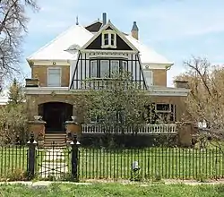 Wrightsman House |
February 14, 1997 (#97000045) |
209 Bauer Ave. 37°20′45″N 108°17′25″W |
Mancos | |
| 35 | Yellowjacket Pueblo (5-MT-5) | September 28, 1985 (#85002701) |
Address Restricted |
Yellow Jacket | ||
| 36 | Yucca House National Monument | 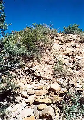 Yucca House National Monument |
October 15, 1966 (#66000252) |
12 miles (19 km) south of Cortez via U.S. Route 666 37°15′00″N 108°41′07″W |
Cortez |
See also
| Wikimedia Commons has media related to National Register of Historic Places in Montezuma County, Colorado. |
References
- The latitude and longitude information provided in this table was derived originally from the National Register Information System, which has been found to be fairly accurate for about 99% of listings. Some locations in this table may have been corrected to current GPS standards.
- "National Register of Historic Places: Weekly List Actions". National Park Service, United States Department of the Interior. Retrieved on February 5, 2021.
- Numbers represent an alphabetical ordering by significant words. Various colorings, defined here, differentiate National Historic Landmarks and historic districts from other NRHP buildings, structures, sites or objects.
- "National Register Information System". National Register of Historic Places. National Park Service. July 9, 2010.
- The eight-digit number below each date is the number assigned to each location in the National Register Information System database, which can be viewed by clicking the number.
| Topics | |
|---|---|
| Lists by state |
|
| Lists by insular areas | |
| Lists by associated state | |
| Other areas | |
| Related | |
| |
Municipalities and communities of Montezuma County, Colorado, United States | ||
|---|---|---|
| City | Map of Colorado highlighting Montezuma County | |
| Towns | ||
| CDP | ||
| Unincorporated communities | ||
| Indian reservations | ||
| Footnotes | ‡This populated place also has portions in an adjacent county or counties | |
| ||
This article is issued from Wikipedia. The text is licensed under Creative Commons - Attribution - Sharealike. Additional terms may apply for the media files.