National Register of Historic Places listings in Garfield County, Colorado
This is a list of the National Register of Historic Places listings in Garfield County, Colorado.
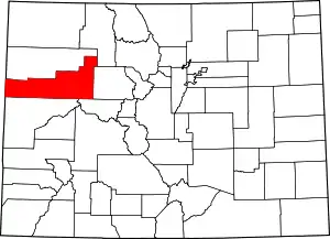
Location of Garfield County in Colorado
This is intended to be a complete list of the properties and districts on the National Register of Historic Places in Garfield County, Colorado, United States. The locations of National Register properties and districts for which the latitude and longitude coordinates are included below, may be seen in a map.[1]
There are 20 properties and districts listed on the National Register in the county.
- This National Park Service list is complete through NPS recent listings posted February 5, 2021.[2]
| Adams - Alamosa - Arapahoe - Archuleta - Baca - Bent - Boulder - Broomfield - Chaffee - Cheyenne - Clear Creek - Conejos - Costilla - Crowley - Custer - Delta - Denver - Dolores - Douglas - Eagle - El Paso - Elbert - Fremont - Garfield - Gilpin - Grand - Gunnison - Hinsdale - Huerfano - Jackson - Jefferson - Kiowa - Kit Carson - La Plata - Lake - Larimer - Las Animas - Lincoln - Logan - Mesa - Mineral - Moffat - Montezuma - Montrose - Morgan - Otero - Ouray - Park - Phillips - Pitkin - Prowers - Pueblo - Rio Blanco - Rio Grande - Routt - Saguache - San Juan - San Miguel - Sedgwick - Summit - Teller - Washington - Weld - Yuma |
Current listings
| [3] | Name on the Register[4] | Image | Date listed[5] | Location | City or town | Description |
|---|---|---|---|---|---|---|
| 1 | Battlement Mesa Schoolhouse | 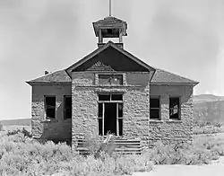 Battlement Mesa Schoolhouse |
April 21, 1983 (#83001295) |
7201 300 Rd. 39°26′05″N 108°01′43″W |
Battlement Mesa | |
| 2 | Canyon (Canon) Creek School, District No. 32 | 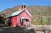 Canyon (Canon) Creek School, District No. 32 |
January 6, 2004 (#03001360) |
0566 County Road 137 39°34′55″N 107°26′54″W |
Glenwood Springs | |
| 3 | Cardiff Coke Ovens | 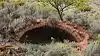 Cardiff Coke Ovens |
November 15, 1996 (#96001331) |
County Road 116 approximately 1.5 miles south of Glenwood 39°30′17″N 107°18′38″W |
Glenwood Springs | |
| 4 | Citizens National Bank Building | 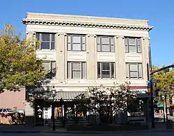 Citizens National Bank Building |
July 15, 1999 (#99000824) |
801 Grand Ave. 39°32′47″N 107°19′27″W |
Glenwood Springs | |
| 5 | Earnest Ranch | 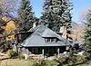 Earnest Ranch |
April 1, 1998 (#98000292) |
6471 County Road 117 39°26′26″N 107°18′42″W |
Glenwood Springs | |
| 6 | Glenwood Springs Hydroelectric Plant | 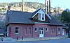 Glenwood Springs Hydroelectric Plant |
October 14, 1998 (#98001244) |
601 6th St. 39°33′01″N 107°19′14″W |
Glenwood Springs | |
| 7 | Havemeyer-Willcox Canal Pumphouse and Forebay | 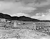 Havemeyer-Willcox Canal Pumphouse and Forebay |
April 22, 1980 (#80000900) |
West of Rifle 39°30′00″N 107°55′05″W |
Rifle | |
| 8 | Holland-Thompson Property | July 23, 2013 (#13000524) |
1605 SH 133 39°23′36″N 107°12′45″W |
Carbondale | ||
| 9 | Hotel Colorado | 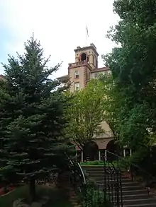 Hotel Colorado |
May 26, 1977 (#77000376) |
526 Pine St. 39°34′25″N 107°19′28″W |
Glenwood Springs | |
| 10 | Missouri Heights School | 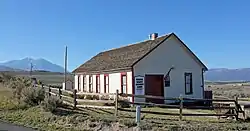 Missouri Heights School |
September 23, 1999 (#99001145) |
County Road 102, 0.5 miles east of its junction with County Road 100 39°25′56″N 107°08′14″W |
Carbondale | |
| 11 | John Herbert Nunns House | 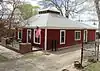 John Herbert Nunns House |
December 3, 2013 (#13000871) |
311 N. 7th St. 39°32′56″N 107°39′22″W |
Silt | |
| 12 | Rifle Bridge | 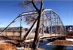 Rifle Bridge |
February 4, 1985 (#85000213) |
Off U.S. Highway 6 over the Colorado River 39°31′40″N 107°46′54″W |
Rifle | Unusual two-span bridge, with one Parker truss and one Pennsylvania truss, spanning the Colorado River since 1909. |
| 13 | Satank Bridge | 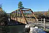 Satank Bridge |
February 4, 1985 (#85000211) |
County Road 106 39°25′02″N 107°13′48″W |
Carbondale | |
| 14 | South Canon Bridge | 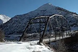 South Canon Bridge |
February 4, 1985 (#85000212) |
County Road 134 39°33′42″N 107°24′23″W |
Glenwood Springs | |
| 15 | Starr Manor | 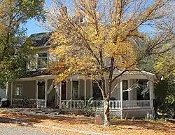 Starr Manor |
June 20, 1986 (#86001350) |
901 Palmer Ave. 39°32′43″N 107°19′13″W |
Glenwood Springs | |
| 16 | Sumers Lodge | 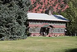 Sumers Lodge |
June 20, 1997 (#97000593) |
1200 Mountain Dr. 39°30′48″N 107°18′53″W |
Glenwood Springs | |
| 17 | Edward T. Taylor House | 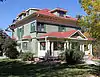 Edward T. Taylor House |
October 14, 1986 (#86002807) |
903 Bennett Ave. 39°32′43″N 107°19′16″W |
Glenwood Springs | |
| 18 | US Post Office-Rifle Main | 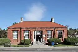 US Post Office-Rifle Main |
January 24, 1986 (#86000186) |
Railroad Ave. and 4th St. 39°31′57″N 107°47′02″W |
Rifle | |
| 19 | Wasson-McKay Place | 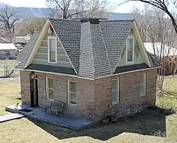 Wasson-McKay Place |
August 5, 2010 (#10000536) |
259 Cardinal Way 39°26′56″N 108°03′08″W |
Parachute | |
| 20 | Western Hotel | 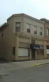 Western Hotel |
March 15, 2016 (#16000074) |
716 Cooper Ave. 39°32′51″N 107°19′25″W |
Glenwood Springs |
See also
| Wikimedia Commons has media related to National Register of Historic Places in Garfield County, Colorado. |
References
- The latitude and longitude information provided in this table was derived originally from the National Register Information System, which has been found to be fairly accurate for about 99% of listings. Some locations in this table may have been corrected to current GPS standards.
- "National Register of Historic Places: Weekly List Actions". National Park Service, United States Department of the Interior. Retrieved on February 5, 2021.
- Numbers represent an alphabetical ordering by significant words. Various colorings, defined here, differentiate National Historic Landmarks and historic districts from other NRHP buildings, structures, sites or objects.
- "National Register Information System". National Register of Historic Places. National Park Service. July 9, 2010.
- The eight-digit number below each date is the number assigned to each location in the National Register Information System database, which can be viewed by clicking the number.
| Topics | |
|---|---|
| Lists by state |
|
| Lists by insular areas | |
| Lists by associated state | |
| Other areas | |
| Related | |
| |
Municipalities and communities of Garfield County, Colorado, United States | ||
|---|---|---|
| Cities | Map of Colorado highlighting Garfield County | |
| Towns | ||
| CDPs | ||
| Unincorporated communities | ||
| ||
This article is issued from Wikipedia. The text is licensed under Creative Commons - Attribution - Sharealike. Additional terms may apply for the media files.