National Register of Historic Places listings in Montrose County, Colorado
This is a list of the National Register of Historic Places listings in Montrose County, Colorado.
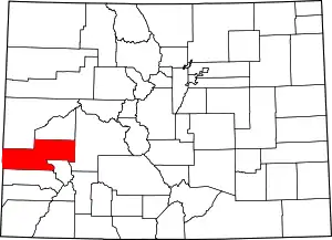
Location of Montrose County in Colorado
This is intended to be a complete list of the properties and districts on the National Register of Historic Places in Montrose County, Colorado, United States. The locations of National Register properties and districts for which the latitude and longitude coordinates are included below, may be seen in a map.[1]
There are 29 properties and districts listed on the National Register in the county.
- This National Park Service list is complete through NPS recent listings posted February 5, 2021.[2]
| Adams - Alamosa - Arapahoe - Archuleta - Baca - Bent - Boulder - Broomfield - Chaffee - Cheyenne - Clear Creek - Conejos - Costilla - Crowley - Custer - Delta - Denver - Dolores - Douglas - Eagle - El Paso - Elbert - Fremont - Garfield - Gilpin - Grand - Gunnison - Hinsdale - Huerfano - Jackson - Jefferson - Kiowa - Kit Carson - La Plata - Lake - Larimer - Las Animas - Lincoln - Logan - Mesa - Mineral - Moffat - Montezuma - Montrose - Morgan - Otero - Ouray - Park - Phillips - Pitkin - Prowers - Pueblo - Rio Blanco - Rio Grande - Routt - Saguache - San Juan - San Miguel - Sedgwick - Summit - Teller - Washington - Weld - Yuma |
Current listings
| [3] | Name on the Register[4] | Image | Date listed[5] | Location | City or town | Description |
|---|---|---|---|---|---|---|
| 1 | Benevolent and Protective Order of Elks Lodge | .JPG.webp) Benevolent and Protective Order of Elks Lodge |
April 6, 2004 (#04000260) |
107 South Cascade Avenue 38°28′43″N 107°52′31″W |
Montrose | |
| 2 | D & RG Narrow Gauge Trestle | 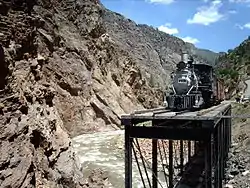 D & RG Narrow Gauge Trestle |
June 18, 1976 (#76000172) |
Northeast of Cimarron 38°27′02″N 107°36′08″W |
Cimarron | |
| 3 | Denver and Rio Grande Depot | 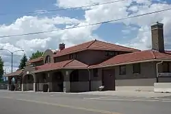 Denver and Rio Grande Depot |
June 3, 1982 (#82002308) |
20 North Rio Grande Avenue 38°28′41″N 107°52′45″W |
Montrose | |
| 4 | Denver & Rio Grande Railroad Box Outfit Car No. 04414 | 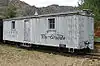 Denver & Rio Grande Railroad Box Outfit Car No. 04414 |
July 23, 2009 (#09000568) |
82800Q 83rd Road, Cimarron Visitor Center, Curecanti National Recreation Area (CURE) 38°26′31″N 107°33′19″W |
Cimarron | |
| 5 | Denver & Rio Grande Western Railroad Boxcar No. 3132 | 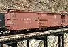 Denver & Rio Grande Western Railroad Boxcar No. 3132 |
September 2, 2009 (#09000669) |
Approximately 1 mile (1.6 km) north by northeast of U.S. Highway 50 at Cimarron, near Morrow Point Dam Road, Curecanti National Recreation Area 38°26′36″N 107°33′19″W |
Cimarron | |
| 6 | Denver & Rio Grande Western Railroad Caboose No. 0577 | 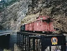 Denver & Rio Grande Western Railroad Caboose No. 0577 |
April 21, 2009 (#09000222) |
Approximately 1 mile (1.6 km) north by northeast of U.S. Highway 50 at Cimarron, adjacent to Morrow Point Dam Road, Curecanti National Recreation Area 38°26′36″N 107°33′19″W |
Cimarron | |
| 7 | Denver & Rio Grande Western Railroad Locomotive No. 278 and Tender | 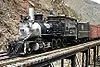 Denver & Rio Grande Western Railroad Locomotive No. 278 and Tender |
April 21, 2009 (#09000223) |
Approximately 1 mile (1.6 km) north by northeast of U.S. Highway 50 at Cimarron, adjacent to Morrow Point Dam Road, Curecanti National Recreation Area 38°26′36″N 107°33′19″W |
Cimarron | |
| 8 | Denver & Rio Grande Western Railroad Stock Car No. 5620 | 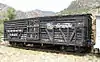 Denver & Rio Grande Western Railroad Stock Car No. 5620 |
January 27, 2010 (#09001276) |
82800Q 83rd Rd. at the Cimarron Visitor Center in the Curecanti National Recreation Area 38°26′36″N 107°33′19″W |
Cimarron | |
| 9 | Denver & Rio Grande Western Railroad Stock Car No. 5679D | 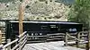 Denver & Rio Grande Western Railroad Stock Car No. 5679D |
January 27, 2010 (#09001277) |
82800Q 83rd Rd. at the Cimarron Visitor Center in the Curecanti National Recreation Area 38°26′36″N 107°33′19″W |
Cimarron | |
| 10 | Dolores River Bridge | 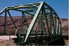 Dolores River Bridge |
October 15, 2002 (#02001150) |
State Highway 90 at milepost 15.22 38°18′38″N 108°53′09″W |
Bedrock | |
| 11 | Fetz-Keller Ranch Headquarters | July 23, 2019 (#100004211) |
61801 CO 90 38°27′01″N 107°56′03″W |
Montrose | ||
| 12 | Gunnison Tunnel | 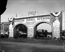 Gunnison Tunnel |
July 22, 1979 (#79000616) |
East of Montrose 38°29′55″N 107°40′38″W |
Montrose | Irrigation water tunnel, which, at time of completion in 1909, was longest such tunnel in the world |
| 13 | Hanging Flume | 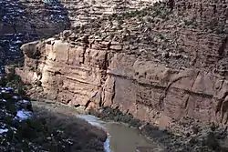 Hanging Flume |
May 15, 1980 (#80000917) |
5.7 miles (9.2 km) northwest of Uravan on State Highway 141 38°24′06″N 108°47′56″W |
Uravan | |
| 14 | Henry Huff Cabin | August 6, 2019 (#100004228) |
Address Restricted |
Naturita vicinity | ||
| 15 | J. V. Lathrop House | 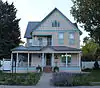 J. V. Lathrop House |
July 8, 1988 (#88001016) |
718 Main Street 38°28′55″N 107°52′19″W |
Montrose | |
| 16 | Methodist Episcopal Church of Montrose | 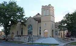 Methodist Episcopal Church of Montrose |
November 30, 1999 (#99001407) |
19 South Park Avenue 38°28′50″N 107°52′24″W |
Montrose | |
| 17 | Montrose City Hall | 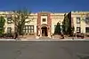 Montrose City Hall |
June 3, 1982 (#82002309) |
433 South 1st Street 38°28′45″N 107°52′29″W |
Montrose | |
| 18 | Montrose County Courthouse | .jpg.webp) Montrose County Courthouse |
February 18, 1994 (#94000040) |
320 South 1st Street 38°28′41″N 107°52′31″W |
Montrose | |
| 19 | Montrose Fruit & Produce Association Building | July 27, 2020 (#100005380) |
39 West Main St. 38°28′37″N 107°52′49″W |
Montrose | ||
| 20 | Montrose Masonic Temple, Lodge No. 63 | 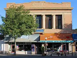 Montrose Masonic Temple, Lodge No. 63 |
April 6, 2004 (#04000259) |
509–513 East Main Street 38°28′51″N 107°52′29″W |
Montrose | |
| 21 | North Rim Road, Black Canyon of the Gunnison National Park | 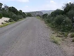 North Rim Road, Black Canyon of the Gunnison National Park |
September 6, 2005 (#05001181) |
Black Canyon of the Gunnison National Park 38°34′23″N 107°41′28″W |
Crawford | |
| 22 | Rio Grande Southern Railroad Derrick Car | 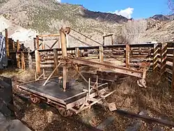 Rio Grande Southern Railroad Derrick Car |
May 10, 2010 (#10000237) |
82800Q 83rd Rd, Cimarron Visitor Center, Curecanti National Recreation Area 38°26′36″N 107°33′19″W |
Cimarron | |
| 23 | Shavano Valley Rock Art Site | October 12, 2001 (#01001106) |
Address Restricted Boundary increase (listed March 27, 2012, refnum 12000147): Montrose vicinity |
Montrose | Site of aboriginal art panels.[6] | |
| 24 | Sherman and Ross Block Building | 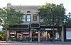 Sherman and Ross Block Building |
April 11, 2003 (#03000196) |
232–236 Main Street 38°28′42″N 107°52′38″W |
Montrose | |
| 25 | Silesca Ranger Station | 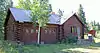 Silesca Ranger Station |
January 12, 2005 (#04001464) |
Grand Mesa in the Uncompahgre and Gunnison National Forests 38°19′56″N 108°07′29″W |
Grand Mesa | |
| 26 | Thomas B. Townsend House | 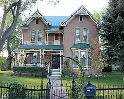 Thomas B. Townsend House |
September 17, 1980 (#80000916) |
222 South 5th Street 38°28′28″N 107°52′23″W |
Montrose | |
| 27 | US Bureau of Reclamation Project Office Building | 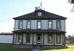 US Bureau of Reclamation Project Office Building |
November 27, 1991 (#91001685) |
601 North Park Avenue 38°29′08″N 107°52′43″W |
Montrose | |
| 28 | US Post Office-Montrose Main | 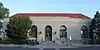 US Post Office-Montrose Main |
January 22, 1986 (#86000183) |
321 South 1st Street 38°28′44″N 107°52′36″W |
Montrose | |
| 29 | Ute Memorial Site | Ute Memorial Site |
February 26, 1970 (#70000167) |
2 miles (3.2 km) south of Montrose on U.S. Highway 550 38°26′04″N 107°52′02″W |
Montrose |
See also
| Wikimedia Commons has media related to National Register of Historic Places in Montrose County, Colorado. |
References
- The latitude and longitude information provided in this table was derived originally from the National Register Information System, which has been found to be fairly accurate for about 99% of listings. Some locations in this table may have been corrected to current GPS standards.
- "National Register of Historic Places: Weekly List Actions". National Park Service, United States Department of the Interior. Retrieved on February 5, 2021.
- Numbers represent an alphabetical ordering by significant words. Various colorings, defined here, differentiate National Historic Landmarks and historic districts from other NRHP buildings, structures, sites or objects.
- "National Register Information System". National Register of Historic Places. National Park Service. July 9, 2010.
- The eight-digit number below each date is the number assigned to each location in the National Register Information System database, which can be viewed by clicking the number.
- "Shavano Valley Rock Art Site". Colorado Encyclopedia.
| Topics | |
|---|---|
| Lists by state |
|
| Lists by insular areas | |
| Lists by associated state | |
| Other areas | |
| Related | |
| |
Municipalities and communities of Montrose County, Colorado, United States | ||
|---|---|---|
| City | Map of Colorado highlighting Montrose County | |
| Towns | ||
| CDP | ||
| Unincorporated communities | ||
| Ghost town | ||
| ||
This article is issued from Wikipedia. The text is licensed under Creative Commons - Attribution - Sharealike. Additional terms may apply for the media files.