National Register of Historic Places listings in Eagle County, Colorado
This is a list of the National Register of Historic Places listings in Eagle County, Colorado.
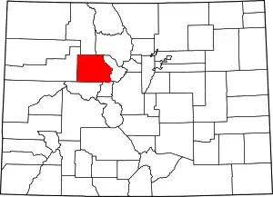
Location of Eagle County in Colorado
This is intended to be a complete list of the properties and districts on the National Register of Historic Places in Eagle County, Colorado, United States. The locations of National Register properties and districts for which the latitude and longitude coordinates are included below, may be seen in a map.[1]
There are 11 properties and districts listed on the National Register in the county. Another 4 properties were once listed but have been removed.
- This National Park Service list is complete through NPS recent listings posted February 5, 2021.[2]
| Adams - Alamosa - Arapahoe - Archuleta - Baca - Bent - Boulder - Broomfield - Chaffee - Cheyenne - Clear Creek - Conejos - Costilla - Crowley - Custer - Delta - Denver - Dolores - Douglas - Eagle - El Paso - Elbert - Fremont - Garfield - Gilpin - Grand - Gunnison - Hinsdale - Huerfano - Jackson - Jefferson - Kiowa - Kit Carson - La Plata - Lake - Larimer - Las Animas - Lincoln - Logan - Mesa - Mineral - Moffat - Montezuma - Montrose - Morgan - Otero - Ouray - Park - Phillips - Pitkin - Prowers - Pueblo - Rio Blanco - Rio Grande - Routt - Saguache - San Juan - San Miguel - Sedgwick - Summit - Teller - Washington - Weld - Yuma |
Current listings
| [3] | Name on the Register[4] | Image | Date listed[5] | Location | City or town | Description |
|---|---|---|---|---|---|---|
| 1 | Archeological Site 5EA484 | May 10, 1982 (#82002299) |
Address Restricted |
Basalt | ||
| 2 | Camp Hale Site | 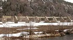 Camp Hale Site |
April 10, 1992 (#78003522) |
Between Leadville and Red Cliff 39°26′38″N 106°19′34″W |
Leadville | Former Army base |
| 3 | First Evangelical Lutheran Church | .JPG.webp) First Evangelical Lutheran Church |
June 24, 1993 (#93000576) |
400 2nd St. 39°38′44″N 106°57′08″W |
Gypsum | |
| 4 | Notch Mountain Shelter | March 10, 2015 (#15000059) |
Notch Mtn. Summit, White River NF 39°28′41″N 106°27′35″W |
Minturn vicinity | ||
| 5 | Red Cliff Bridge | 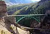 Red Cliff Bridge |
February 4, 1985 (#85000204) |
U.S. Highway 24 39°30′29″N 106°22′34″W |
Red Cliff | |
| 6 | State Bridge | 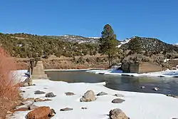 State Bridge |
June 24, 1985 (#85001401) |
Off State Highway 131 39°51′29″N 106°38′54″W |
State Bridge | |
| 7 | Tigiwon Community House | March 10, 2015 (#15000060) |
FSR 707, Holy Cross Dist., White River NF 39°31′24″N 106°25′14″W |
Minturn vicinity | ||
| 8 | Upper Brush Creek School |  Upper Brush Creek School |
April 6, 2015 (#15000126) |
Between Coulter Meadow & W. Brush Cr. Rds. 39°32′09″N 106°45′10″W |
Eagle vicinity | In/near Sylvan Lake State Park |
| 9 | Waterwheel | 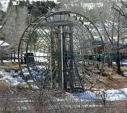 Waterwheel |
April 11, 1977 (#77000372) |
Southeast of McCoy at the Colorado River 39°54′10″N 106°43′02″W |
McCoy | Water wheel set into Colorado River which lifted water 32 feet (9.8 m) for use in irrigation. |
| 10 | Woods Lake Resort | August 11, 1988 (#88001226) |
11 miles (18 km) north of Thomasville at Woods Lake 39°25′32″N 106°37′35″W |
Thomasville | ||
| 11 | Yarmony Archeological Site | May 28, 1991 (#91000615) |
Address Restricted |
Radium |
Former listings
| [3] | Name on the Register | Image | Date listed | Date removed | Location | City or town | Summary |
|---|---|---|---|---|---|---|---|
| 1 | Dotsero Bridge | 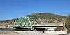 Dotsero Bridge |
October 15, 2002 (#02001155) | November 9, 2017 | Interstate 70 service road at milepost 133.51 39°38′57″N 107°03′47″W |
Dotsero | Demolished |
| 2 | Eagle River Bridge | 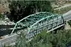 Eagle River Bridge |
October 15, 2002 (#02001156) | November 9, 2017 | U.S. Highway 6 at milepost 150.24 39°39′36″N 106°48′55″W |
Eagle | |
| 3 | Wolcott Bridge | October 15, 2002 (#02001157) | March 20, 2011 | State Highway 131 at milepost 0.07 39°42′06″N 106°40′39″W |
Wolcott | Part of the Highway Bridges in Colorado Multiple Property Submission | |
| 4 | Wolcott Stage Station | 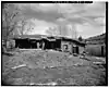 Wolcott Stage Station |
August 22, 1975 (#75000518) | May 31, 1989 | N bank of Eagle River off SH 131 |
Wolcott | Also known as the Bocco House |
See also
| Wikimedia Commons has media related to National Register of Historic Places in Eagle County, Colorado. |
References
- The latitude and longitude information provided in this table was derived originally from the National Register Information System, which has been found to be fairly accurate for about 99% of listings. Some locations in this table may have been corrected to current GPS standards.
- "National Register of Historic Places: Weekly List Actions". National Park Service, United States Department of the Interior. Retrieved on February 5, 2021.
- Numbers represent an alphabetical ordering by significant words. Various colorings, defined here, differentiate National Historic Landmarks and historic districts from other NRHP buildings, structures, sites or objects.
- "National Register Information System". National Register of Historic Places. National Park Service. July 9, 2010.
- The eight-digit number below each date is the number assigned to each location in the National Register Information System database, which can be viewed by clicking the number.
| Topics | |
|---|---|
| Lists by state |
|
| Lists by insular areas | |
| Lists by associated state | |
| Other areas | |
| Related | |
| |
Municipalities and communities of Eagle County, Colorado, United States | ||
|---|---|---|
| Towns | Map of Colorado highlighting Eagle County | |
| CDPs | ||
| Unincorporated communities |
| |
| Ghost towns | ||
| Footnotes | ‡This populated place also has portions in an adjacent county or counties | |
| ||
This article is issued from Wikipedia. The text is licensed under Creative Commons - Attribution - Sharealike. Additional terms may apply for the media files.