National Register of Historic Places listings in Morgan County, Colorado
This is a list of the National Register of Historic Places listings in Morgan County, Colorado.
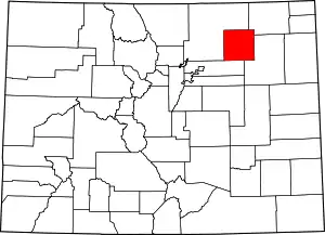
Location of Morgan County in Colorado
This is intended to be a complete list of the properties and districts on the National Register of Historic Places in Morgan County, Colorado, United States. The locations of National Register properties and districts for which the latitude and longitude coordinates are included below, may be seen in a map.[1]
There are 16 properties and districts listed on the National Register in the county.
- This National Park Service list is complete through NPS recent listings posted February 5, 2021.[2]
| Adams - Alamosa - Arapahoe - Archuleta - Baca - Bent - Boulder - Broomfield - Chaffee - Cheyenne - Clear Creek - Conejos - Costilla - Crowley - Custer - Delta - Denver - Dolores - Douglas - Eagle - El Paso - Elbert - Fremont - Garfield - Gilpin - Grand - Gunnison - Hinsdale - Huerfano - Jackson - Jefferson - Kiowa - Kit Carson - La Plata - Lake - Larimer - Las Animas - Lincoln - Logan - Mesa - Mineral - Moffat - Montezuma - Montrose - Morgan - Otero - Ouray - Park - Phillips - Pitkin - Prowers - Pueblo - Rio Blanco - Rio Grande - Routt - Saguache - San Juan - San Miguel - Sedgwick - Summit - Teller - Washington - Weld - Yuma |
Current listings
| [3] | Name on the Register[4] | Image | Date listed[5] | Location | City or town | Description |
|---|---|---|---|---|---|---|
| 1 | All Saints Church of Eben Ezer | 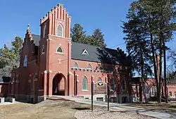 All Saints Church of Eben Ezer |
June 3, 1982 (#82002310) |
120 Hospital Rd. 40°15′15″N 103°38′38″W |
Brush | |
| 2 | Antelope Springs Methodist Episcopal Church | 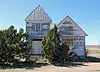 Antelope Springs Methodist Episcopal Church |
December 3, 2013 (#13000872) |
Address Restricted |
Snyder | |
| 3 | Central Platoon School | Central Platoon School |
November 5, 2001 (#01001194) |
411 Clayton St. 40°15′29″N 103°37′20″W |
Brush | |
| 4 | Farmers State Bank Building | 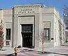 Farmers State Bank Building |
September 13, 1990 (#90001422) |
300 Main St. 40°15′00″N 103°48′02″W |
Fort Morgan | |
| 5 | Fort Morgan City Hall | 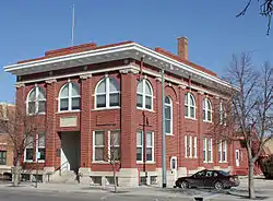 Fort Morgan City Hall |
November 22, 1995 (#95001339) |
110 Main St. 40°14′52″N 103°48′02″W |
Fort Morgan | |
| 6 | Fort Morgan Power Plant Building | 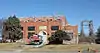 Fort Morgan Power Plant Building |
January 28, 1994 (#93001553) |
Eastern side of N. Main St., north of its junction with U.S. Highway 6 40°15′56″N 103°48′02″W |
Fort Morgan | |
| 7 | Fort Morgan State Armory | 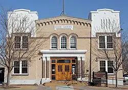 Fort Morgan State Armory |
June 16, 2004 (#04000596) |
528 State St. 40°15′13″N 103°47′57″W |
Fort Morgan | |
| 8 | German Evangelical Immanuel Congregational Church | 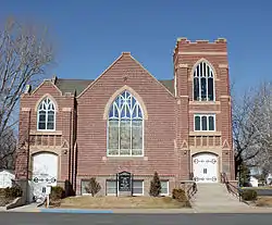 German Evangelical Immanuel Congregational Church |
October 14, 2005 (#05001161) |
209 Everett St. 40°15′35″N 103°37′13″W |
Brush | |
| 9 | Knearl School | 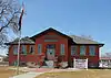 Knearl School |
January 31, 1997 (#97000017) |
314 S. Clayton St. 40°15′02″N 103°37′23″W |
Brush | |
| 10 | Lincoln School | .JPG.webp) Lincoln School |
April 27, 2010 (#10000216) |
914 State St. 40°15′30″N 103°48′01″W |
Fort Morgan | |
| 11 | Morgan County Courthouse and Jail | 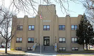 Morgan County Courthouse and Jail |
April 1, 2002 (#02000289) |
225 Ensign and 218 W. Kiowa 40°14′59″N 103°48′10″W |
Fort Morgan | |
| 12 | Old Trail School | 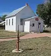 Old Trail School |
April 20, 2004 (#04000337) |
421 High St. 40°13′34″N 104°04′18″W |
Wiggins | |
| 13 | Rainbow Arch Bridge | .JPG.webp) Rainbow Arch Bridge |
February 4, 1985 (#85000221) |
State Highway 52 40°16′09″N 103°48′02″W |
Fort Morgan | |
| 14 | Rankin Presbyterian Church | 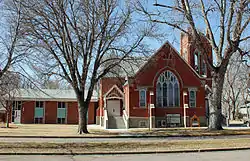 Rankin Presbyterian Church |
July 18, 2007 (#07000696) |
420 Clayton St. 40°15′30″N 103°37′23″W |
Brush | |
| 15 | Sherman Street Historic Residential District | 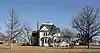 Sherman Street Historic Residential District |
September 10, 1987 (#87001286) |
400 and 500 blocks of Sherman St. 40°15′06″N 103°47′26″W |
Fort Morgan | |
| 16 | US Post Office-Fort Morgan Main | US Post Office-Fort Morgan Main |
January 22, 1986 (#86000177) |
300 State St. 40°14′57″N 103°47′58″W |
Fort Morgan |
See also
| Wikimedia Commons has media related to National Register of Historic Places in Morgan County, Colorado. |
References
- The latitude and longitude information provided in this table was derived originally from the National Register Information System, which has been found to be fairly accurate for about 99% of listings. Some locations in this table may have been corrected to current GPS standards.
- "National Register of Historic Places: Weekly List Actions". National Park Service, United States Department of the Interior. Retrieved on February 5, 2021.
- Numbers represent an alphabetical ordering by significant words. Various colorings, defined here, differentiate National Historic Landmarks and historic districts from other NRHP buildings, structures, sites or objects.
- "National Register Information System". National Register of Historic Places. National Park Service. July 9, 2010.
- The eight-digit number below each date is the number assigned to each location in the National Register Information System database, which can be viewed by clicking the number.
| Topics | |
|---|---|
| Lists by state |
|
| Lists by insular areas | |
| Lists by associated state | |
| Other areas | |
| Related | |
| |
Municipalities and communities of Morgan County, Colorado, United States | ||
|---|---|---|
| Cities | Map of Colorado highlighting Morgan County | |
| Towns | ||
| CDPs | ||
| Unincorporated communities |
| |
| Ghost towns | ||
| ||
This article is issued from Wikipedia. The text is licensed under Creative Commons - Attribution - Sharealike. Additional terms may apply for the media files.