National Register of Historic Places listings in Fremont County, Colorado
This is a list of the National Register of Historic Places listings in Fremont County, Colorado.
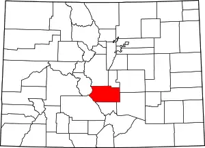
Location of Fremont County in Colorado
This is intended to be a complete list of the properties and districts on the National Register of Historic Places in Fremont County, Colorado, United States. The locations of National Register properties and districts for which the latitude and longitude coordinates are included below, may be seen in a map.[1]
There are 22 properties and districts listed on the National Register in the county. Another 4 properties were once listed but have been removed.
- This National Park Service list is complete through NPS recent listings posted February 5, 2021.[2]
| Adams - Alamosa - Arapahoe - Archuleta - Baca - Bent - Boulder - Broomfield - Chaffee - Cheyenne - Clear Creek - Conejos - Costilla - Crowley - Custer - Delta - Denver - Dolores - Douglas - Eagle - El Paso - Elbert - Fremont - Garfield - Gilpin - Grand - Gunnison - Hinsdale - Huerfano - Jackson - Jefferson - Kiowa - Kit Carson - La Plata - Lake - Larimer - Las Animas - Lincoln - Logan - Mesa - Mineral - Moffat - Montezuma - Montrose - Morgan - Otero - Ouray - Park - Phillips - Pitkin - Prowers - Pueblo - Rio Blanco - Rio Grande - Routt - Saguache - San Juan - San Miguel - Sedgwick - Summit - Teller - Washington - Weld - Yuma |
Current listings
| [3] | Name on the Register[4] | Image | Date listed[5] | Location | City or town | Description |
|---|---|---|---|---|---|---|
| 1 | Samuel H. Atwater House | 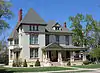 Samuel H. Atwater House |
March 7, 1996 (#96000241) |
821 Macon Ave. 38°26′36″N 105°14′12″W |
Cañon City | |
| 2 | Bridge No. 10/Adelaide Bridge | Bridge No. 10/Adelaide Bridge |
February 4, 1985 (#85000208) |
Fremont County Road 38°34′17″N 105°05′10″W |
Florence | |
| 3 | Cañon City Downtown Historic District |  Cañon City Downtown Historic District |
October 20, 1983 (#83003517) |
Roughly Main St. from 3rd to 9th Sts. and Macon Ave.; also 602 Macon Ave. 38°26′29″N 105°14′17″W |
Cañon City | 602 Macon Ave. represents a boundary increase of February 6, 1986 |
| 4 | Cañon City Municipal Building | 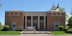 Cañon City Municipal Building |
August 18, 1983 (#83001318) |
612 Royal Gorge Boulevard 38°26′57″N 105°14′16″W |
Cañon City | |
| 5 | Cañon City State Armory | 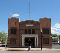 Cañon City State Armory |
August 20, 1999 (#99001011) |
110 Main St. 38°26′17″N 105°14′42″W |
Cañon City | |
| 6 | Christ Episcopal Church | .JPG.webp) Christ Episcopal Church |
August 19, 1994 (#94001011) |
802 Harrison Ave. 38°26′41″N 105°14′16″W |
Cañon City | |
| 7 | Colorado Women's Prison | 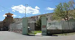 Colorado Women's Prison |
March 5, 1999 (#99000265) |
201 N. 1st St. 38°26′21″N 105°14′48″W |
Cañon City | |
| 8 | Deputy Warden's House | 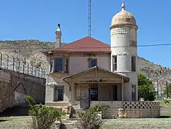 Deputy Warden's House |
May 2, 2001 (#01000443) |
105 Main 38°26′18″N 105°14′45″W |
Cañon City | |
| 9 | First Presbyterian Church | .JPG.webp) First Presbyterian Church |
September 1, 1983 (#83001319) |
Macon and 7th Sts. 38°26′35″N 105°14′18″W |
Cañon City | |
| 10 | Downtown Florence Historic District | 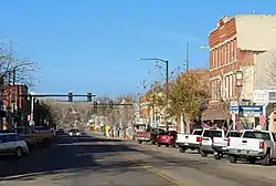 Downtown Florence Historic District |
July 14, 2017 (#100001309) |
Roughly bounded by Main St., Santa Fe & Petroleum Aves. between W. 2nd & Railroad Sts. 38°23′24″N 105°07′04″W |
Florence | |
| 11 | Greenwood Cemetery | .JPG.webp) Greenwood Cemetery |
September 4, 2013 (#13000661) |
1251 S. 1st St. 38°25′40″N 105°14′49″W |
Cañon City | |
| 12 | Holy Cross Abbey | 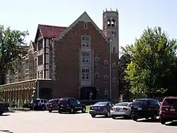 Holy Cross Abbey |
August 18, 1983 (#83001320) |
U.S. Highway 50 38°26′56″N 105°12′01″W |
Cañon City | |
| 13 | Main Street Bridge | .JPG.webp) Main Street Bridge |
October 15, 2002 (#02001145) |
State Highway 115 at milepost 8.90 38°23′21″N 105°06′48″W |
Florence | |
| 14 | McClure House | 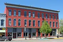 McClure House |
September 14, 1979 (#79000609) |
323-331 Main St. 38°26′24″N 105°14′30″W |
Cañon City | |
| 15 | Mount Saint Scholastica Academy, East Building | 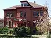 Mount Saint Scholastica Academy, East Building |
January 15, 1998 (#97001646) |
615 Pike Ave. 38°26′50″N 105°14′30″W |
Cañon City | |
| 16 | Oil Spring | February 16, 1996 (#96000043) |
Address Restricted |
Cañon City | ||
| 17 | Robison Mansion | 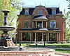 Robison Mansion |
October 11, 1984 (#84000022) |
12 Riverside Dr. 38°26′02″N 105°14′39″W |
Cañon City | |
| 18 | Rouch Gulch Bridge | 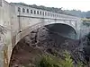 Rouch Gulch Bridge |
November 27, 2002 (#02001410) |
U.S. Highway 50 at milepost 230.12 38°28′20″N 105°52′38″W |
Swissvale | |
| 19 | Royal Gorge Bridge and Incline Railway | 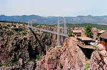 Royal Gorge Bridge and Incline Railway |
September 2, 1983 (#83001303) |
Northwest of Cañon City 38°27′53″N 105°19′32″W |
Cañon City | |
| 20 | South Canon High School | 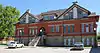 South Canon High School |
October 24, 2005 (#00001648) |
1020 Park Ave. 38°26′07″N 105°13′43″W |
Cañon City | Now used as apartments. |
| 21 | U.S. Post Office and Federal Building–Cañon City Main | 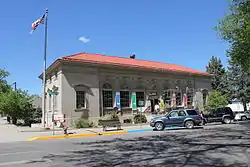 U.S. Post Office and Federal Building–Cañon City Main |
January 22, 1986 (#86000167) |
5th St. and Macon Ave. 38°26′29″N 105°14′27″W |
Cañon City | |
| 22 | US Post Office–Florence Main | US Post Office–Florence Main |
January 22, 1986 (#86000174) |
121 N. Pikes Peak St. 38°23′27″N 105°07′03″W |
Florence |
Former listings
| [3] | Name on the Register | Image | Date listed | Date removed | Location | City or town | Summary |
|---|---|---|---|---|---|---|---|
| 1 | Fourth Street Bridge | 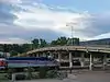 Fourth Street Bridge |
February 4, 1985 (#85000207) | January 14, 2010 | 4th St. 38°26′22″N 105°13′52″W |
Cañon City | |
| 2 | Howard Bridge | February 4, 1985 (#85000209) | September 16, 2002 | Off U.S. Highway 50 |
Howard | ||
| 3 | Portland Bridge | 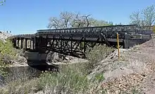 Portland Bridge |
February 4, 1985 (#85000210) | November 13, 2017 | State Highway 120 38°23′19″N 105°00′56″W |
Portland | Replaced in 2014. |
| 4 | Rio Grande Railroad Viaduct | 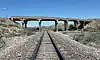 Rio Grande Railroad Viaduct |
October 15, 2002 (#02001148) | November 13, 2017 | State Highway 120 at milepost 0.17 38°23′10″N 105°04′18″W |
Florence |
See also
| Wikimedia Commons has media related to National Register of Historic Places in Fremont County, Colorado. |
References
- The latitude and longitude information provided in this table was derived originally from the National Register Information System, which has been found to be fairly accurate for about 99% of listings. Some locations in this table may have been corrected to current GPS standards.
- "National Register of Historic Places: Weekly List Actions". National Park Service, United States Department of the Interior. Retrieved on February 5, 2021.
- Numbers represent an alphabetical ordering by significant words. Various colorings, defined here, differentiate National Historic Landmarks and historic districts from other NRHP buildings, structures, sites or objects.
- "National Register Information System". National Register of Historic Places. National Park Service. July 9, 2010.
- The eight-digit number below each date is the number assigned to each location in the National Register Information System database, which can be viewed by clicking the number.
| Topics | |
|---|---|
| Lists by state |
|
| Lists by insular areas | |
| Lists by associated state | |
| Other areas | |
| Related | |
| |
Municipalities and communities of Fremont County, Colorado, United States | ||
|---|---|---|
| Cities | Map of Colorado highlighting Fremont County | |
| Towns | ||
| CDPs | ||
| Unincorporated communities | ||
| Ghost towns | ||
| ||
This article is issued from Wikipedia. The text is licensed under Creative Commons - Attribution - Sharealike. Additional terms may apply for the media files.