National Register of Historic Places listings in Mesa County, Colorado
This is a list of the National Register of Historic Places listings in Mesa County, Colorado.
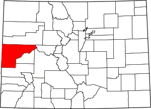
Location of Mesa County in Colorado
This is intended to be a complete list of the properties and districts on the National Register of Historic Places in Mesa County, Colorado, United States. The locations of National Register properties and districts for which the latitude and longitude coordinates are included below, may be seen in a map.[1]
There are 35 properties and districts listed on the National Register in the county. Another 2 properties were once listed but have been removed.
- This National Park Service list is complete through NPS recent listings posted January 29, 2021.[2]
| Adams - Alamosa - Arapahoe - Archuleta - Baca - Bent - Boulder - Broomfield - Chaffee - Cheyenne - Clear Creek - Conejos - Costilla - Crowley - Custer - Delta - Denver - Dolores - Douglas - Eagle - El Paso - Elbert - Fremont - Garfield - Gilpin - Grand - Gunnison - Hinsdale - Huerfano - Jackson - Jefferson - Kiowa - Kit Carson - La Plata - Lake - Larimer - Las Animas - Lincoln - Logan - Mesa - Mineral - Moffat - Montezuma - Montrose - Morgan - Otero - Ouray - Park - Phillips - Pitkin - Prowers - Pueblo - Rio Blanco - Rio Grande - Routt - Saguache - San Juan - San Miguel - Sedgwick - Summit - Teller - Washington - Weld - Yuma |
Current listings
| [3] | Name on the Register[4] | Image | Date listed[5] | Location | City or town | Description |
|---|---|---|---|---|---|---|
| 1 | Bloomfield Site | January 20, 1983 (#83001324) |
Address Restricted |
Whitewater | ||
| 2 | Calamity Camp | June 1, 2011 (#11000313) |
Address Restricted |
Gateway | Mining Industry in Colorado MPS | |
| 3 | Cayton Guard Station | April 27, 2005 (#05000335) |
Forest Service Road 814.1 39°18′20″N 107°33′53″W |
Silt | Log cabin built in 1910 to serve National Forest rangers. | |
| 4 | Clifton Community Center and Church | 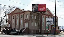 Clifton Community Center and Church |
June 3, 1982 (#82002307) |
F and Front St. 39°05′29″N 108°26′57″W |
Clifton | |
| 5 | Coates Creek Schoolhouse | 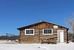 Coates Creek Schoolhouse |
February 3, 1993 (#92001839) |
D S Rd., 16 miles (26 km) west of Glade Park 38°56′55″N 108°58′35″W |
Glade Park | One-room schoolhouse. |
| 6 | Colorado National Monument Visitor Center Complex | 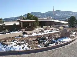 Colorado National Monument Visitor Center Complex |
July 15, 2003 (#03000647) |
Colorado National Monument 39°06′07″N 108°43′50″W |
Fruita | |
| 7 | Colorado River Bridge | 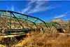 Colorado River Bridge |
October 15, 2002 (#02001154) |
Interstate 70 frontage road at milepost 62.90 39°20′20″N 108°11′36″W |
De Beque | |
| 8 | Convicts' Bread Oven | 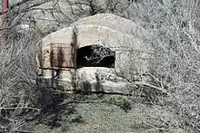 Convicts' Bread Oven |
December 31, 1974 (#74000589) |
West of Molina on State Highway 65 39°12′02″N 108°11′29″W |
Molina | |
| 9 | Herbert and Edith Crissey House | 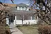 Herbert and Edith Crissey House |
May 18, 2003 (#03000402) |
218 W. 1st St. 39°06′44″N 108°21′07″W |
Palisade | |
| 10 | Cross Land and Fruit Company Orchards and Ranch | 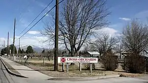 Cross Land and Fruit Company Orchards and Ranch |
March 28, 1980 (#80000912) |
Northeast of Grand Junction at 3079 F Rd. 39°05′28″N 108°28′52″W |
Grand Junction | |
| 11 | De Beque House | 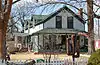 De Beque House |
July 28, 1995 (#95000936) |
233 Denver Ave. 39°19′49″N 108°13′04″W |
De Beque | |
| 12 | Denver and Rio Grande Western Railroad Depot | 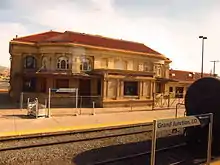 Denver and Rio Grande Western Railroad Depot |
September 8, 1992 (#92001190) |
119 Pitkin Ave. 39°03′51″N 108°34′09″W |
Grand Junction | |
| 13 | Department of Energy Grand Junction Office | 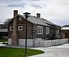 Department of Energy Grand Junction Office |
July 26, 2016 (#16000470) |
2591 Legacy Way 39°02′31″N 108°34′21″W |
Grand Junction | |
| 14 | Devils Kitchen Picnic Shelter |  Devils Kitchen Picnic Shelter |
April 21, 1994 (#94000309) |
Colorado National Monument 39°01′58″N 108°37′59″W |
Grand Junction | |
| 15 | Fruita Bridge | 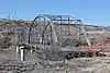 Fruita Bridge |
February 4, 1985 (#85000218) |
17 1/2 Rd over the Colorado River 39°08′13″N 108°43′50″W |
Fruita | |
| 16 | Fruita Museum | 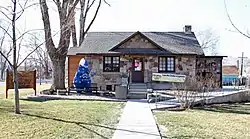 Fruita Museum |
October 10, 1996 (#96001080) |
432 E. Aspen 39°08′59″N 108°43′45″W |
Fruita | |
| 17 | Grand Valley Diversion Dam | 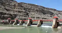 Grand Valley Diversion Dam |
October 8, 1991 (#91001485) |
Across the Colorado River north of its confluence with Plateau Creek, 8 miles (13 km) northeast of Palisade 39°11′20″N 108°16′53″W |
Palisade | |
| 18 | Handy Chapel | 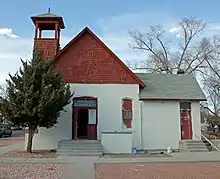 Handy Chapel |
August 19, 1994 (#94001012) |
202 White Ave. 39°04′10″N 108°34′07″W |
Grand Junction | |
| 19 | Hotel St. Regis | .JPG.webp) Hotel St. Regis |
October 22, 1992 (#92001410) |
359 Colorado Ave. 39°03′58″N 108°33′56″W |
Grand Junction | |
| 20 | IOOF Hall | .JPG.webp) IOOF Hall |
March 25, 1993 (#93000200) |
Junction of 4th St. and Curtis Ave. 39°20′00″N 108°12′51″W |
De Beque | |
| 21 | Kettle-Jens House | 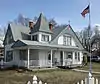 Kettle-Jens House |
May 6, 1983 (#83001325) |
498 32 Rd. 39°04′37″N 108°27′31″W |
Clifton | |
| 22 | Land's End Observatory | 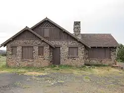 Land's End Observatory |
February 28, 1997 (#97000124) |
Land's End Rd., 10 miles (16 km) west of State Highway 65 39°01′30″N 108°13′25″W |
Whitewater | |
| 23 | Loma Community Hall | .jpg.webp) Loma Community Hall |
November 22, 1995 (#95001338) |
1341 13 Road 39°11′56″N 108°48′47″W |
Loma | |
| 24 | Margery Building | 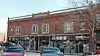 Margery Building |
February 24, 1993 (#93000033) |
519-527 Main St. 39°04′02″N 108°33′48″W |
Grand Junction | |
| 25 | North Seventh Street Historic Residential District | 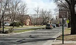 North Seventh Street Historic Residential District |
January 5, 1984 (#84000870) |
7th St. between Hill and White Aves. 39°04′19″N 108°33′37″W |
Grand Junction | |
| 26 | Harry and Lilly Phillips House | 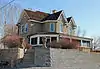 Harry and Lilly Phillips House |
November 13, 1997 (#97001419) |
798 N. Mesa St. 39°10′21″N 108°43′58″W |
Fruita | |
| 27 | Pipe Line School | 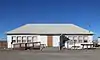 Pipe Line School |
April 29, 1999 (#99000483) |
101 16.5 S Rd. 38°59′50″N 108°44′27″W |
Glade Park | |
| 28 | Rim Rock Drive Historic District | 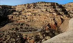 Rim Rock Drive Historic District |
April 21, 1994 (#94000310) |
Colorado National Monument 39°03′25″N 108°42′04″W |
Grand Junction | |
| 29 | Saddlehorn Caretaker's House and Garage | 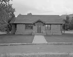 Saddlehorn Caretaker's House and Garage |
April 21, 1994 (#94000306) |
Colorado National Monument 39°06′05″N 108°43′59″W |
Grand Junction | |
| 30 | Saddlehorn Comfort Station | 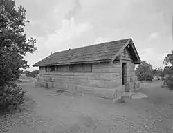 Saddlehorn Comfort Station |
April 21, 1994 (#94000305) |
Colorado National Monument 39°06′17″N 108°44′23″W |
Grand Junction | |
| 31 | Saddlehorn Utility Area Historic District | 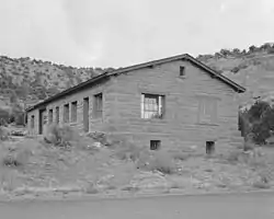 Saddlehorn Utility Area Historic District |
April 21, 1994 (#94000308) |
Colorado National Monument 39°06′05″N 108°44′17″W |
Grand Junction | |
| 32 | Serpents Trail | 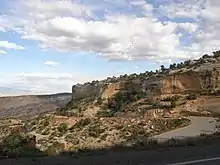 Serpents Trail |
April 21, 1994 (#94000307) |
Colorado National Monument 39°01′53″N 108°38′11″W |
Grand Junction | |
| 33 | Stranges Grocery | .jpg.webp) Stranges Grocery |
March 20, 2013 (#13000079) |
226 Pitkin Ave. 39°03′53″N 108°34′08″W |
Grand Junction | |
| 34 | TBM Avenger Aircraft N53503 | November 13, 2017 (#100001791) |
CAF Rocky Mountain Wing Museum, 780 Heritage Way, Grand Junction Regional Airport 39°07′04″N 108°31′31″W |
Grand Junction | ||
| 35 | U.S. Post Office | .JPG.webp) U.S. Post Office |
January 31, 1980 (#80000913) |
400 Rood Ave. 39°04′07″N 108°33′55″W |
Grand Junction |
Former listings
| [3] | Name on the Register | Image | Date listed | Date removed | Location | City or town | Summary |
|---|---|---|---|---|---|---|---|
| 1 | Black Bridge | Black Bridge |
1985 (#85000219) | July 22, 1994 | 25 3/10 Rd over the Gunnison River |
Grand Junction | Damaged by flooding in 1983. |
| 2 | Fifth Street Bridge | 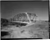 Fifth Street Bridge |
1985 (#85000220) | July 22, 1994 | Northbound U.S. Highway 50 over the Colorado River |
Grand Junction | Replaced in 1989. |
See also
| Wikimedia Commons has media related to National Register of Historic Places in Mesa County, Colorado. |
References
- The latitude and longitude information provided in this table was derived originally from the National Register Information System, which has been found to be fairly accurate for about 99% of listings. Some locations in this table may have been corrected to current GPS standards.
- "National Register of Historic Places: Weekly List Actions". National Park Service, United States Department of the Interior. Retrieved on January 29, 2021.
- Numbers represent an alphabetical ordering by significant words. Various colorings, defined here, differentiate National Historic Landmarks and historic districts from other NRHP buildings, structures, sites or objects.
- "National Register Information System". National Register of Historic Places. National Park Service. July 9, 2010.
- The eight-digit number below each date is the number assigned to each location in the National Register Information System database, which can be viewed by clicking the number.
| Topics | |
|---|---|
| Lists by state |
|
| Lists by insular areas | |
| Lists by associated state | |
| Other areas | |
| Related | |
| |
Municipalities and communities of Mesa County, Colorado, United States | ||
|---|---|---|
| Cities | Map of Colorado highlighting Mesa County | |
| Towns | ||
| CDPs | ||
| Unincorporated communities | ||
| Ghost towns | ||
| ||
This article is issued from Wikipedia. The text is licensed under Creative Commons - Attribution - Sharealike. Additional terms may apply for the media files.