National Register of Historic Places listings in Rio Grande County, Colorado
This is a list of the National Register of Historic Places listings in Rio Grande County, Colorado.
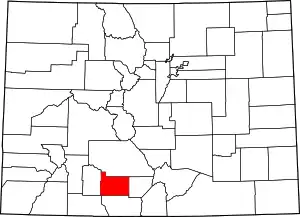
Location of Rio Grande County in Colorado
This is intended to be a complete list of the properties and districts on the National Register of Historic Places in Rio Grande County, Colorado, United States. The locations of National Register properties and districts for which the latitude and longitude coordinates are included below, may be seen in a map.[1]
There are 13 properties and districts listed on the National Register in the county. Another property was once listed but has been removed.
- This National Park Service list is complete through NPS recent listings posted February 5, 2021.[2]
| Adams - Alamosa - Arapahoe - Archuleta - Baca - Bent - Boulder - Broomfield - Chaffee - Cheyenne - Clear Creek - Conejos - Costilla - Crowley - Custer - Delta - Denver - Dolores - Douglas - Eagle - El Paso - Elbert - Fremont - Garfield - Gilpin - Grand - Gunnison - Hinsdale - Huerfano - Jackson - Jefferson - Kiowa - Kit Carson - La Plata - Lake - Larimer - Las Animas - Lincoln - Logan - Mesa - Mineral - Moffat - Montezuma - Montrose - Morgan - Otero - Ouray - Park - Phillips - Pitkin - Prowers - Pueblo - Rio Blanco - Rio Grande - Routt - Saguache - San Juan - San Miguel - Sedgwick - Summit - Teller - Washington - Weld - Yuma |
Current listings
| [3] | Name on the Register[4] | Image | Date listed[5] | Location | City or town | Description |
|---|---|---|---|---|---|---|
| 1 | Carnegie Library | .JPG.webp) Carnegie Library |
April 14, 1995 (#95000439) |
120 Jefferson St. 37°34′48″N 106°08′40″W |
Monte Vista | |
| 2 | Central School Auditorium and Gymnasium | 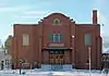 Central School Auditorium and Gymnasium |
March 14, 1996 (#96000274) |
612 1st Ave. 37°34′46″N 106°08′59″W |
Monte Vista | |
| 3 | Creede Branch, Denver and Rio Grande Railroad | 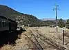 Creede Branch, Denver and Rio Grande Railroad |
November 27, 2002 (#02001408) |
Along the D&RGW right-of-way between South Fork and Creede 37°44′46″N 106°22′13″W |
South Fork | |
| 4 | Denver & Rio Grande Railroad South Fork Water Tank | 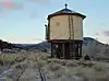 Denver & Rio Grande Railroad South Fork Water Tank |
October 15, 2002 (#02001132) |
U.S. Route 160 37°40′18″N 106°37′31″W |
South Fork | |
| 5 | El Monte Hotel | 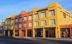 El Monte Hotel |
June 7, 1990 (#90000870) |
925 1st Ave. 37°34′50″N 106°08′43″W |
Monte Vista | |
| 6 | First Methodist Episcopal Church | .JPG.webp) First Methodist Episcopal Church |
October 11, 2003 (#03001011) |
215 Washington St. 37°34′44″N 106°08′52″W |
Monte Vista | |
| 7 | Keck Homestead | May 8, 1998 (#98000437) |
12888 County Road 15 37°42′00″N 106°26′03″W |
Del Norte | ||
| 8 | Monte Vista Downtown Historic District |  Monte Vista Downtown Historic District |
November 1, 1991 (#91001612) |
Junction of 1st Ave. and Washington St. 37°34′50″N 106°08′51″W |
Monte Vista | |
| 9 | Monte Vista Library |  Monte Vista Library |
June 30, 1995 (#95000782) |
110 Jefferson St. 37°34′48″N 106°08′40″W |
Monte Vista | |
| 10 | Spruce Lodge | 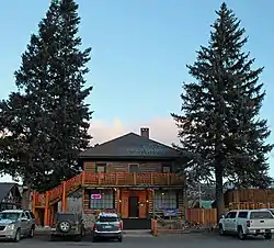 Spruce Lodge |
October 21, 2008 (#08001009) |
29431 U.S. Route 160 37°40′22″N 106°37′24″W |
South Fork | |
| 11 | Sutherland Bridge | 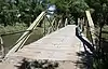 Sutherland Bridge |
February 4, 1985 (#85000234) |
Off U.S. Route 160 37°40′35″N 106°19′36″W |
Del Norte | Warren Pony Truss |
| 12 | US Post Office and Federal Building-Monte Vista Main |  US Post Office and Federal Building-Monte Vista Main |
January 22, 1986 (#86000182) |
Washington and 2nd Ave. 37°34′45″N 106°08′39″W |
Monte Vista | |
| 13 | Wheeler Bridge | 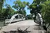 Wheeler Bridge |
February 4, 1985 (#85000235) |
Off U.S. Route 160 37°39′29″N 106°17′20″W |
Del Norte | Howe Pony Truss |
Former listing
| [3] | Name on the Register | Image | Date listed | Date removed | Location | City or town | Summary |
|---|---|---|---|---|---|---|---|
| 1 | Masonic Park Bridge | February 4, 1985 (#85000236) | July 22, 1994 | Masonic Park Drive over Rio Grande 37°42′02″N 106°41′09″W |
South Fork | Replaced in 1994. |
See also
| Wikimedia Commons has media related to National Register of Historic Places in Rio Grande County, Colorado. |
References
- The latitude and longitude information provided in this table was derived originally from the National Register Information System, which has been found to be fairly accurate for about 99% of listings. Some locations in this table may have been corrected to current GPS standards.
- "National Register of Historic Places: Weekly List Actions". National Park Service, United States Department of the Interior. Retrieved on February 5, 2021.
- Numbers represent an alphabetical ordering by significant words. Various colorings, defined here, differentiate National Historic Landmarks and historic districts from other NRHP buildings, structures, sites or objects.
- "National Register Information System". National Register of Historic Places. National Park Service. July 9, 2010.
- The eight-digit number below each date is the number assigned to each location in the National Register Information System database, which can be viewed by clicking the number.
| Topics | |
|---|---|
| Lists by state |
|
| Lists by insular areas | |
| Lists by associated state | |
| Other areas | |
| Related | |
| |
Municipalities and communities of Rio Grande County, Colorado, United States | ||
|---|---|---|
| City | Map of Colorado highlighting Rio Grande County | |
| Towns | ||
| CDPs | ||
| Unincorporated community | ||
| Footnotes | ‡This populated place also has portions in an adjacent county or counties | |
| ||
This article is issued from Wikipedia. The text is licensed under Creative Commons - Attribution - Sharealike. Additional terms may apply for the media files.