National Register of Historic Places listings in Saguache County, Colorado
This is a list of the National Register of Historic Places listings in Saguache County, Colorado.
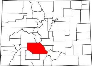
Location of Saguache County in Colorado
This is intended to be a complete list of the properties and districts on the National Register of Historic Places in Saguache County, Colorado, United States. The locations of National Register properties and districts for which the latitude and longitude coordinates are included below, may be seen in a map.[1]
There are 9 properties and districts listed on the National Register in the county.
- This National Park Service list is complete through NPS recent listings posted January 29, 2021.[2]
| Adams - Alamosa - Arapahoe - Archuleta - Baca - Bent - Boulder - Broomfield - Chaffee - Cheyenne - Clear Creek - Conejos - Costilla - Crowley - Custer - Delta - Denver - Dolores - Douglas - Eagle - El Paso - Elbert - Fremont - Garfield - Gilpin - Grand - Gunnison - Hinsdale - Huerfano - Jackson - Jefferson - Kiowa - Kit Carson - La Plata - Lake - Larimer - Las Animas - Lincoln - Logan - Mesa - Mineral - Moffat - Montezuma - Montrose - Morgan - Otero - Ouray - Park - Phillips - Pitkin - Prowers - Pueblo - Rio Blanco - Rio Grande - Routt - Saguache - San Juan - San Miguel - Sedgwick - Summit - Teller - Washington - Weld - Yuma |
Current listings
| [3] | Name on the Register[4] | Image | Date listed[5] | Location | City or town | Description |
|---|---|---|---|---|---|---|
| 1 | Capilla de San Juan Bautista | 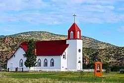 Capilla de San Juan Bautista |
February 8, 1980 (#80000926) |
Northwest of La Garita 37°51′01″N 106°15′46″W |
La Garita | |
| 2 | Carnero Creek Pictographs | June 5, 1975 (#75000540) |
Address Restricted |
La Garita | ||
| 3 | Crestone School | 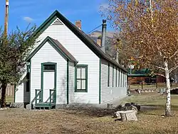 Crestone School |
January 9, 1986 (#86000011) |
Cottonwood St. and Carbonate Ave. 37°59′48″N 105°41′57″W |
Crestone | |
| 4 | First Baptist Church of Moffat | 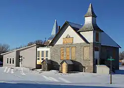 First Baptist Church of Moffat |
July 24, 2008 (#08000710) |
401 Lincoln Ave. 37°59′54″N 105°54′20″W |
Moffat | Ornamental Concrete Block Buildings in Colorado Multiple Property Submission |
| 5 | Indian Grove | March 24, 2000 (#00000237) |
Address Restricted |
Mosca | ||
| 6 | Saguache Downtown Historic District | Saguache Downtown Historic District |
July 25, 2014 (#14000433) |
Roughly 300 & 400 blocks of 4th St. 38°05′14″N 106°08′13″W |
Saguache | |
| 7 | Saguache Flour Mill | 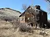 Saguache Flour Mill |
September 18, 1978 (#78000885) |
West of Saguache 38°04′53″N 106°09′38″W |
Saguache | |
| 8 | Saguache School and Jail Buildings | 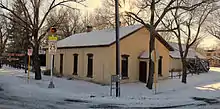 Saguache School and Jail Buildings |
May 2, 1975 (#75000541) |
U.S. Highway 285 and San Juan Ave. 38°05′16″N 106°08′38″W |
Saguache | |
| 9 | Sargents Water Tank, Denver and Rio Grande Railroad, Western Line | 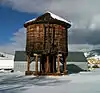 Sargents Water Tank, Denver and Rio Grande Railroad, Western Line |
August 12, 2010 (#10000537) |
45 Front St. 38°24′16″N 106°24′57″W |
Sargents | Railroads in Colorado, 1858-1948 MPS |
See also
| Wikimedia Commons has media related to National Register of Historic Places in Saguache County, Colorado. |
References
- The latitude and longitude information provided in this table was derived originally from the National Register Information System, which has been found to be fairly accurate for about 99% of listings. Some locations in this table may have been corrected to current GPS standards.
- "National Register of Historic Places: Weekly List Actions". National Park Service, United States Department of the Interior. Retrieved on January 29, 2021.
- Numbers represent an alphabetical ordering by significant words. Various colorings, defined here, differentiate National Historic Landmarks and historic districts from other NRHP buildings, structures, sites or objects.
- "National Register Information System". National Register of Historic Places. National Park Service. July 9, 2010.
- The eight-digit number below each date is the number assigned to each location in the National Register Information System database, which can be viewed by clicking the number.
| Topics | |
|---|---|
| Lists by state |
|
| Lists by insular areas | |
| Lists by associated state | |
| Other areas | |
| Related | |
| |
Municipalities and communities of Saguache County, Colorado, United States | ||
|---|---|---|
| Towns | Map of Colorado highlighting Saguache County | |
| Unincorporated communities | ||
| Footnotes | ‡This populated place also has portions in an adjacent county or counties | |
| ||
This article is issued from Wikipedia. The text is licensed under Creative Commons - Attribution - Sharealike. Additional terms may apply for the media files.