National Register of Historic Places listings in Conejos County, Colorado
This is a list of the National Register of Historic Places listings in Conejos County, Colorado.
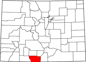
Location of Conejos County in Colorado
This is intended to be a complete list of the properties and districts on the National Register of Historic Places in Conejos County, Colorado, United States. The locations of National Register properties and districts for which the latitude and longitude coordinates are included below, may be seen in a map.[1]
There are 13 properties and districts listed on the National Register in the county, including 2 National Historic Landmark.
- This National Park Service list is complete through NPS recent listings posted January 29, 2021.[2]
| Adams - Alamosa - Arapahoe - Archuleta - Baca - Bent - Boulder - Broomfield - Chaffee - Cheyenne - Clear Creek - Conejos - Costilla - Crowley - Custer - Delta - Denver - Dolores - Douglas - Eagle - El Paso - Elbert - Fremont - Garfield - Gilpin - Grand - Gunnison - Hinsdale - Huerfano - Jackson - Jefferson - Kiowa - Kit Carson - La Plata - Lake - Larimer - Las Animas - Lincoln - Logan - Mesa - Mineral - Moffat - Montezuma - Montrose - Morgan - Otero - Ouray - Park - Phillips - Pitkin - Prowers - Pueblo - Rio Blanco - Rio Grande - Routt - Saguache - San Juan - San Miguel - Sedgwick - Summit - Teller - Washington - Weld - Yuma |
Current listings
| [3] | Name on the Register[4] | Image | Date listed[5] | Location | City or town | Description |
|---|---|---|---|---|---|---|
| 1 | Costilla Crossing Bridge | 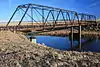 Costilla Crossing Bridge |
February 4, 1985 (#85000194) |
County Road over the Rio Grande 37°04′43″N 105°45′22″W |
Antonito | Built 1892, rehabilitated 2006 |
| 2 | Denver & Rio Grande Railroad San Juan Extension |  Denver & Rio Grande Railroad San Juan Extension |
February 6, 1973 (#73000462) |
Between Antonito and Chama, New Mexico via Cumbres Pass 36°51′56″N 106°23′56″W |
Antonito | Now a scenic railway, the Cumbres and Toltec Scenic Railroad; extends into Archuleta County |
| 3 | Engine No. 463 |  Engine No. 463 |
May 12, 1975 (#75000502) |
Off U.S. Route 285 37°04′12″N 106°00′38″W |
Antonito | |
| 4 | Garcia-Espinosa-Garland Ranch Headquarters | December 31, 2018 (#100003274) |
7527 County Rd. 16 Coordinates missing |
Antonito | ||
| 5 | La Jara Depot | 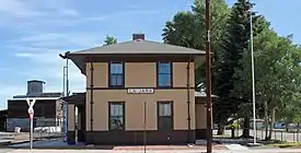 La Jara Depot |
May 12, 1975 (#75000503) |
Broadway and Main Sts. 37°16′31″N 105°57′35″W |
La Jara | |
| 6 | McIntire Ranch | March 26, 2008 (#08000204) |
Approximately 1.5 miles north of County Road V 37°16′50″N 105°49′05″W |
Sanford | ||
| 7 | Our Lady of Guadalupe Church | December 17, 2018 (#100003275) |
6631-33 County Road 13 37°05′18″N 106°01′13″W |
Conejos | ||
| 8 | Palace Hotel | .JPG.webp) Palace Hotel |
August 19, 1994 (#94001013) |
429 Main St. 37°04′35″N 106°00′30″W |
Antonito | |
| 9 | Pike's Stockade |  Pike's Stockade |
October 15, 1966 (#66000244) |
4 miles east of Sanford on State Highway 136 37°17′37″N 105°48′36″W |
Sanford | |
| 10 | Rio Grande Engine No. 168 | 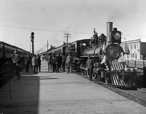 Rio Grande Engine No. 168 |
August 10, 1979 (#79000601) |
5234B U.S. 285 37°04′07″N 106°00′50″W |
Antonito | |
| 11 | S.P.M.D.T.U. Concilio Superior | 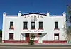 S.P.M.D.T.U. Concilio Superior |
March 29, 2001 (#01000322) |
603 Main St. 37°04′35″N 106°00′30″W |
Antonito | |
| 12 | St. Joseph's Church | December 31, 2018 (#100003276) |
19895 County Road 8 37°16′55″N 106°06′42″W |
Capulin | ||
| 13 | Warshauer Mansion | 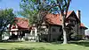 Warshauer Mansion |
August 30, 1974 (#74000564) |
515 River St. 37°04′34″N 106°00′36″W |
Antonito |
See also
| Wikimedia Commons has media related to National Register of Historic Places in Conejos County, Colorado. |
References
- The latitude and longitude information provided in this table was derived originally from the National Register Information System, which has been found to be fairly accurate for about 99% of listings. Some locations in this table may have been corrected to current GPS standards.
- "National Register of Historic Places: Weekly List Actions". National Park Service, United States Department of the Interior. Retrieved on January 29, 2021.
- Numbers represent an alphabetical ordering by significant words. Various colorings, defined here, differentiate National Historic Landmarks and historic districts from other NRHP buildings, structures, sites or objects.
- "National Register Information System". National Register of Historic Places. National Park Service. July 9, 2010.
- The eight-digit number below each date is the number assigned to each location in the National Register Information System database, which can be viewed by clicking the number.
| Topics | |
|---|---|
| Lists by state |
|
| Lists by insular areas | |
| Lists by associated state | |
| Other areas | |
| Related | |
| |
Municipalities and communities of Conejos County, Colorado, United States | ||
|---|---|---|
| Towns | Map of Colorado highlighting Conejos County | |
| CDPs | ||
| Unincorporated communities | ||
| ||
This article is issued from Wikipedia. The text is licensed under Creative Commons - Attribution - Sharealike. Additional terms may apply for the media files.