National Register of Historic Places listings in Grand County, Colorado
This is a list of the National Register of Historic Places listings in Grand County, Colorado.
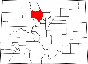
Location of Grand County in Colorado
This is intended to be a complete list of the properties and districts on the National Register of Historic Places in Grand County, Colorado, United States. The locations of National Register properties and districts for which the latitude and longitude coordinates are included below, may be seen in a map.[1]
There are 27 properties and districts listed on the National Register in the county. Another 2 properties were once listed but have been removed.
- This National Park Service list is complete through NPS recent listings posted January 29, 2021.[2]
| Adams - Alamosa - Arapahoe - Archuleta - Baca - Bent - Boulder - Broomfield - Chaffee - Cheyenne - Clear Creek - Conejos - Costilla - Crowley - Custer - Delta - Denver - Dolores - Douglas - Eagle - El Paso - Elbert - Fremont - Garfield - Gilpin - Grand - Gunnison - Hinsdale - Huerfano - Jackson - Jefferson - Kiowa - Kit Carson - La Plata - Lake - Larimer - Las Animas - Lincoln - Logan - Mesa - Mineral - Moffat - Montezuma - Montrose - Morgan - Otero - Ouray - Park - Phillips - Pitkin - Prowers - Pueblo - Rio Blanco - Rio Grande - Routt - Saguache - San Juan - San Miguel - Sedgwick - Summit - Teller - Washington - Weld - Yuma |
Current listings
| [3] | Name on the Register[4] | Image | Date listed[5] | Location | City or town | Description |
|---|---|---|---|---|---|---|
| 1 | Barger Gulch Locality B | March 25, 2009 (#08001377) |
Address Restricted |
Kremmling | ||
| 2 | Byers Peak Ranch | March 12, 2018 (#100002177) |
1102 St. Louis Creek Rd. 39°56′41″N 105°49′36″W |
Fraser vicinity | ||
| 3 | Cozens Ranch House |  Cozens Ranch House |
June 9, 1988 (#88000709) |
U.S. Highway 40 1½ miles south of Fraser 39°55′56″N 105°47′24″W |
Fraser | |
| 4 | Denver, Northwestern and Pacific Railway Historic District |  Denver, Northwestern and Pacific Railway Historic District |
September 30, 1980 (#80000881) |
Southwest of Eldora 39°54′52″N 105°41′10″W |
Winter Park | Extends into Gilpin and Boulder counties, covering the railroad route over Rollins Pass. |
| 5 | Dutchtown | January 29, 1988 (#76002292) |
Ditch Rd. 40°26′16″N 105°52′55″W |
Grand Lake | Mining settlement high in the Neversummer Mountains | |
| 6 | East Inlet Trail | 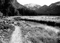 East Inlet Trail |
February 28, 2005 (#05000073) |
Rocky Mountain National Park 39°54′37″N 105°44′30″W |
Estes Park | |
| 7 | Grand Lake Lodge | 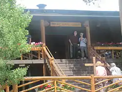 Grand Lake Lodge |
July 22, 1993 (#93000663) |
15500 U.S. Highway 34 40°15′27″N 105°49′30″W |
Grand Lake | |
| 8 | Grand River Ditch | 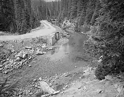 Grand River Ditch |
September 29, 1976 (#76000218) |
North of Grand Lake 40°25′10″N 105°52′12″W |
Grand Lake | |
| 9 | Greenwood Lodge | November 29, 2010 (#10000948) |
161 County Road 451 40°12′41″N 105°53′19″W |
Grand Lake | ||
| 10 | Holzwarth Historic District |  Holzwarth Historic District |
December 2, 1977 (#77000112) |
North of Grand Lake on Trail Ridge Road 40°22′13″N 105°51′28″W |
Grand Lake | |
| 11 | Kauffman House |  Kauffman House |
November 21, 1974 (#74000579) |
Northwestern corner of Pitkin and Lake Ave. 40°15′02″N 105°49′04″W |
Grand Lake | |
| 12 | Kenjockety | November 30, 2011 (#11000858) |
Junction of Elk and Willow Creeks[6] 40°18′42″N 106°02′58″W |
Rand | ||
| 13 | Little Buckaroo Ranch Barn | 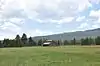 Little Buckaroo Ranch Barn |
July 8, 2009 (#09000490) |
20631 Trail Ridge Road in Rocky Mountain National Park 40°21′22″N 105°51′23″W |
Grand Lake | |
| 14 | Lulu City Site |  Lulu City Site |
September 14, 1977 (#77001562) |
North of Grand Lake on Trail Ridge Rd. 40°26′30″N 105°50′50″W |
Grand Lake | |
| 15 | Milner Pass Road Camp Mess Hall and House | 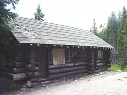 Milner Pass Road Camp Mess Hall and House |
July 20, 1987 (#87001130) |
Milner Pass Rd. 40°25′02″N 105°48′57″W |
Estes Park | |
| 16 | North Inlet Trail | 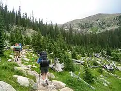 North Inlet Trail |
March 5, 2008 (#08000127) |
Roughly along North Inlet and Hallett Creek to Flattop Mt.[7] 40°15′50″N 105°47′22″W |
Grand Lake | Extends into Larimer County |
| 17 | Shadow Mountain Lookout | 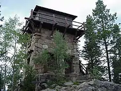 Shadow Mountain Lookout |
August 2, 1978 (#78000279) |
Southeast of Grand Lake in Rocky Mountain National Park 40°13′50″N 105°48′52″W |
Grand Lake | |
| 18 | Shadow Mountain Trail | .jpg.webp) Shadow Mountain Trail |
March 5, 2008 (#08000124) |
Eastern side of Shadow Mountain Lake[8] 40°13′40″N 105°49′08″W |
Grand Lake | |
| 19 | Smith-Eslick Cottage Court | August 4, 2016 (#16000491) |
729 Lake Ave. 40°15′04″N 105°49′24″W |
Grand Lake | ||
| 20 | Timber Creek Campground Comfort Station No. 245 |  Timber Creek Campground Comfort Station No. 245 |
January 29, 1988 (#87001131) |
Timber Creek Campground 40°22′50″N 105°51′05″W |
Estes Park | |
| 21 | Timber Creek Campground Comfort Station No. 246 | 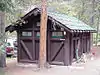 Timber Creek Campground Comfort Station No. 246 |
January 29, 1988 (#87001132) |
Timber Creek Campground 40°22′49″N 105°51′00″W |
Estes Park | |
| 22 | Timber Creek Campground Comfort Station No. 247 | 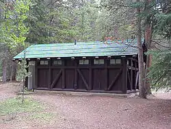 Timber Creek Campground Comfort Station No. 247 |
January 29, 1988 (#87001133) |
Timber Creek Campground 40°22′42″N 105°51′05″W |
Estes Park | |
| 23 | Timber Creek Road Camp Barn | 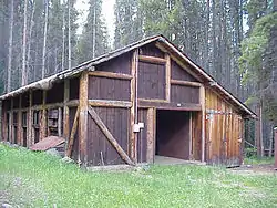 Timber Creek Road Camp Barn |
July 30, 1987 (#87001134) |
Approximately 200 yards south of Columbine Lake Rd., 450 yards west of the Kawuneeche Visitor Center 40°22′45″N 105°50′53″W |
Estes Park | |
| 24 | Timberline Cabin | 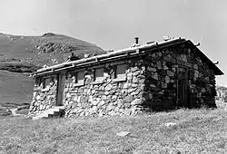 Timberline Cabin |
January 29, 1988 (#87001136) |
Fall River Rd. 40°26′30″N 105°44′37″W |
Estes Park | Demolished.[9] |
| 25 | Tonahutu Creek Trail |  Tonahutu Creek Trail |
March 5, 2008 (#08000130) |
Roughly along Tonahutu Creek to Flattop Mountain[10] 40°19′10″N 105°46′32″W |
Grand Lake | Extends into Larimer County |
| 26 | Trail Ridge Road | 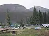 Trail Ridge Road |
November 14, 1984 (#84000242) |
Rocky Mountain National Park 40°21′30″N 105°45′47″W |
Grand Lake | Extends into Larimer County |
| 27 | E.C. Yust Homestead | E.C. Yust Homestead |
October 29, 1982 (#82001019) |
South of Kremmling off State Highway 9 39°59′40″N 106°23′11″W |
Kremmling |
Former listings
| [3] | Name on the Register | Image | Date listed | Date removed | Location | City or town | Summary |
|---|---|---|---|---|---|---|---|
| 1 | North Inlet Shelter Cabin | October 22, 1976 (#76000205) | February 27, 1987 | 6 miles east of Grand Lake in Rocky Mountain National Park |
Grand Lake | Destroyed by avalanche in March or April 1986[11] | |
| 2 | Timber Creek Road Camp Storage Building | January 29, 1988 (#87001135) | February 11, 1992 | Timber Creek Rd. |
Rocky Mountain National Park | Collapsed |
See also
| Wikimedia Commons has media related to National Register of Historic Places in Grand County, Colorado. |
References
- The latitude and longitude information provided in this table was derived originally from the National Register Information System, which has been found to be fairly accurate for about 99% of listings. Some locations in this table may have been corrected to current GPS standards.
- "National Register of Historic Places: Weekly List Actions". National Park Service, United States Department of the Interior. Retrieved on January 29, 2021.
- Numbers represent an alphabetical ordering by significant words. Various colorings, defined here, differentiate National Historic Landmarks and historic districts from other NRHP buildings, structures, sites or objects.
- "National Register Information System". National Register of Historic Places. National Park Service. July 9, 2010.
- The eight-digit number below each date is the number assigned to each location in the National Register Information System database, which can be viewed by clicking the number.
- Location derived from Shellenbarger, Melanie. High Country Summers: The Emergence and Development of the Second Home in Colorado, 1880-1940. Ann Arbor: ProQuest, 2008, 224. The NRIS lists the site as "Address Restricted".
- Coordinates are those of the Grand Lake end of the trail as provided by its GNIS record; the NRIS gives neither coordinates or a community
- Coordinates are provided by its GNIS record; the NRIS gives no coordinates
- "Listing of Historic Non-Extant Structures Records" (PDF). National Park Service. Retrieved 2014-03-17.
- Coordinates are those of the Grand Lake end of the trail as provided by its GNIS record; the NRIS gives no coordinates
| Topics | |
|---|---|
| Lists by state |
|
| Lists by insular areas | |
| Lists by associated state | |
| Other areas | |
| Related | |
| |
Municipalities and communities of Grand County, Colorado, United States | ||
|---|---|---|
| Towns | Map of Colorado highlighting Grand County | |
| CDPs | ||
| Unincorporated communities |
| |
| Ghost towns | ||
| ||
This article is issued from Wikipedia. The text is licensed under Creative Commons - Attribution - Sharealike. Additional terms may apply for the media files.