National Register of Historic Places listings in Clear Creek County, Colorado
This is a list of the National Register of Historic Places listings in Clear Creek County, Colorado.
Location of Clear Creek County in Colorado
This is intended to be a complete list of the properties and districts on the National Register of Historic Places in Clear Creek County, Colorado, United States. The locations of National Register properties and districts for which the latitude and longitude coordinates are included below, may be seen in a map.[1]
There are 25 properties and districts listed on the National Register in the county, including 1 National Historic Landmark.
- This National Park Service list is complete through NPS recent listings posted January 29, 2021.[2]
| Adams - Alamosa - Arapahoe - Archuleta - Baca - Bent - Boulder - Broomfield - Chaffee - Cheyenne - Clear Creek - Conejos - Costilla - Crowley - Custer - Delta - Denver - Dolores - Douglas - Eagle - El Paso - Elbert - Fremont - Garfield - Gilpin - Grand - Gunnison - Hinsdale - Huerfano - Jackson - Jefferson - Kiowa - Kit Carson - La Plata - Lake - Larimer - Las Animas - Lincoln - Logan - Mesa - Mineral - Moffat - Montezuma - Montrose - Morgan - Otero - Ouray - Park - Phillips - Pitkin - Prowers - Pueblo - Rio Blanco - Rio Grande - Routt - Saguache - San Juan - San Miguel - Sedgwick - Summit - Teller - Washington - Weld - Yuma |
Current listings
| [3] | Name on the Register[4] | Image | Date listed[5] | Location | City or town | Description |
|---|---|---|---|---|---|---|
| 1 | Alpine Hose Company No. 2 | 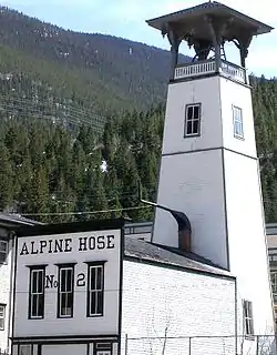 Alpine Hose Company No. 2 |
January 25, 1973 (#73000464) |
507 5th St. 39°42′19″N 105°41′48″W |
Georgetown | |
| 2 | Argo Tunnel and Mill | 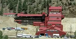 Argo Tunnel and Mill |
January 31, 1978 (#78000836) |
2517 Riverside Dr. 39°44′35″N 105°30′17″W |
Idaho Springs | |
| 3 | Bryan Hose House | .jpg.webp) Bryan Hose House |
March 19, 1998 (#98000174) |
Junction of Illinois and Virginia Sts. 39°44′37″N 105°30′46″W |
Idaho Springs | |
| 4 | Dumont School | 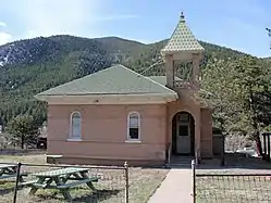 Dumont School |
March 1, 1996 (#96000201) |
150 County Road 260 39°45′56″N 105°36′13″W |
Dumont | |
| 5 | Echo Lake Park | 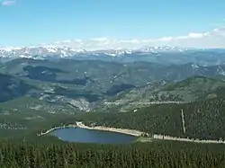 Echo Lake Park |
February 24, 1995 (#95000109) |
Along State Highways 5 and 103 southwest of Idaho Springs 39°39′33″N 105°36′03″W |
Idaho Springs | |
| 6 | Anne Evans Mountain Home | January 28, 1992 (#91001530) |
Address Restricted |
Evergreen | ||
| 7 | Evans-Elbert Ranch | September 11, 1980 (#80000885) |
Upper Bear Creek Rd. 39°39′10″N 105°28′49″W |
Idaho Springs | ||
| 8 | Georgetown Loop Railroad | 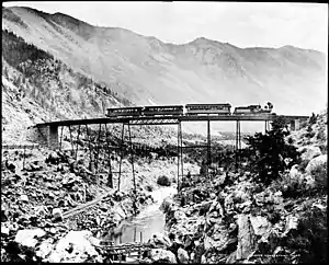 Georgetown Loop Railroad |
December 18, 1970 (#70000909) |
Runs between Georgetown and Silver Plume 39°41′56″N 105°42′42″W |
Georgetown and Silver Plume | |
| 9 | Georgetown-Silver Plume Historic District | Georgetown-Silver Plume Historic District |
November 13, 1966 (#66000243) |
Interstate 70 39°41′55″N 105°42′48″W |
Georgetown and Silver Plume | |
| 10 | Grace Episcopal Church | 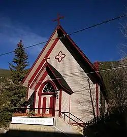 Grace Episcopal Church |
August 14, 1973 (#73000465) |
Taos St. between 4th and 5th Sts. 39°42′19″N 105°41′46″W |
Georgetown | |
| 11 | Hamill House | 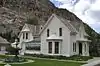 Hamill House |
May 31, 1972 (#72000267) |
Argentine and 3rd Sts. 39°42′17″N 105°41′55″W |
Georgetown | |
| 12 | Hose House No. 2 | 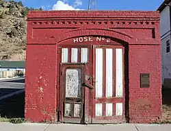 Hose House No. 2 |
March 19, 1998 (#98000173) |
600 Colorado Boulevard 39°44′39″N 105°31′33″W |
Idaho Springs | |
| 13 | Hotel de Paris | 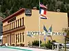 Hotel de Paris |
April 28, 1970 (#70000154) |
Alpine St. 39°42′20″N 105°41′27″W |
Georgetown | |
| 14 | Idaho Springs Downtown Commercial District | 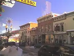 Idaho Springs Downtown Commercial District |
January 5, 1984 (#84000801) |
Roughly bounded by Center Alley, 14th Ave., Riverside Dr., and Idaho St. 39°44′32″N 105°30′56″W |
Idaho Springs | |
| 15 | Lebanon and Everett Mine Tunnels | 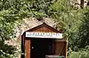 Lebanon and Everett Mine Tunnels |
October 7, 1971 (#71000214) |
Northeast of Silver Plume, adjacent to the Interstate 70 right-of-way 39°41′54″N 105°42′47″W |
Silver Plume | |
| 16 | McClellan House | 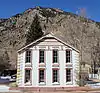 McClellan House |
December 5, 1972 (#72000268) |
919 Taos St. 39°41′57″N 105°41′43″W |
Georgetown | |
| 17 | Methodist Episcopal Church | .JPG.webp) Methodist Episcopal Church |
March 5, 1998 (#98000176) |
1440 Colorado Boulevard 39°44′35″N 105°31′00″W |
Idaho Springs | |
| 18 | Mill City House | 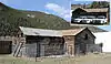 Mill City House |
April 30, 2009 (#09000250) |
247 County Road 308 39°45′52″N 105°35′59″W |
Dumont | |
| 19 | Miner Street Bridge | 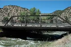 Miner Street Bridge |
February 4, 1985 (#85000193) |
Miner St. 39°44′40″N 105°30′45″W |
Idaho Springs | |
| 20 | Mint Saloon | 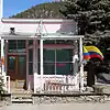 Mint Saloon |
February 3, 1993 (#92001845) |
13 E. Park Ave. (U.S. Highway 40) 39°45′40″N 105°40′55″W |
Empire | |
| 21 | Ore Processing Mill and Dam | May 6, 1971 (#71000213) |
1 mile southwest of Georgetown off Interstate 70 39°41′54″N 105°42′44″W |
Georgetown | ||
| 22 | Peck House | Peck House |
March 25, 1993 (#93000201) |
83 Sunny Ave. 39°45′46″N 105°40′59″W |
Empire | |
| 23 | Silver Plume Depot | 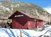 Silver Plume Depot |
May 6, 1971 (#71000215) |
Off Interstate 70 39°41′44″N 105°43′24″W |
Silver Plume | |
| 24 | Summit Lake Park |  Summit Lake Park |
February 24, 1995 (#95000110) |
Mt. Evans Rd., southwest of Idaho Springs 39°35′55″N 105°38′40″W |
Idaho Springs | |
| 25 | Toll House | December 18, 1970 (#70000155) |
Southern side of Georgetown adjacent to Interstate 70 39°42′15″N 105°42′12″W |
Georgetown | Gothic Revival house from before 1878 which sat beside gates of private toll road between silver mines. |
See also
| Wikimedia Commons has media related to National Register of Historic Places in Clear Creek County, Colorado. |
References
- The latitude and longitude information provided in this table was derived originally from the National Register Information System, which has been found to be fairly accurate for about 99% of listings. Some locations in this table may have been corrected to current GPS standards.
- "National Register of Historic Places: Weekly List Actions". National Park Service, United States Department of the Interior. Retrieved on January 29, 2021.
- Numbers represent an alphabetical ordering by significant words. Various colorings, defined here, differentiate National Historic Landmarks and historic districts from other NRHP buildings, structures, sites or objects.
- "National Register Information System". National Register of Historic Places. National Park Service. July 9, 2010.
- The eight-digit number below each date is the number assigned to each location in the National Register Information System database, which can be viewed by clicking the number.
| Topics | |
|---|---|
| Lists by state |
|
| Lists by insular areas | |
| Lists by associated state | |
| Other areas | |
| Related | |
| |
Municipalities and communities of Clear Creek County, Colorado, United States | ||
|---|---|---|
| Cities | Map of Colorado highlighting Clear Creek County | |
| Towns | ||
| CDPs | ||
| Unincorporated communities | ||
| Ghost towns |
| |
| Footnotes | ‡This populated place also has portions in an adjacent county or counties | |
| ||
This article is issued from Wikipedia. The text is licensed under Creative Commons - Attribution - Sharealike. Additional terms may apply for the media files.