National Register of Historic Places listings in La Plata County, Colorado
This is a list of the National Register of Historic Places listings in La Plata County, Colorado.
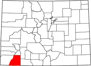
Location of La Plata County in Colorado
This is intended to be a complete list of the properties and districts on the National Register of Historic Places in La Plata County, Colorado, United States. The locations of National Register properties and districts for which the latitude and longitude coordinates are included below, may be seen in a map.[1]
There are 16 properties and districts listed on the National Register in the county.
- This National Park Service list is complete through NPS recent listings posted February 5, 2021.[2]
| Adams - Alamosa - Arapahoe - Archuleta - Baca - Bent - Boulder - Broomfield - Chaffee - Cheyenne - Clear Creek - Conejos - Costilla - Crowley - Custer - Delta - Denver - Dolores - Douglas - Eagle - El Paso - Elbert - Fremont - Garfield - Gilpin - Grand - Gunnison - Hinsdale - Huerfano - Jackson - Jefferson - Kiowa - Kit Carson - La Plata - Lake - Larimer - Las Animas - Lincoln - Logan - Mesa - Mineral - Moffat - Montezuma - Montrose - Morgan - Otero - Ouray - Park - Phillips - Pitkin - Prowers - Pueblo - Rio Blanco - Rio Grande - Routt - Saguache - San Juan - San Miguel - Sedgwick - Summit - Teller - Washington - Weld - Yuma |
Current listings
| [3] | Name on the Register[4] | Image | Date listed[5] | Location | City or town | Description |
|---|---|---|---|---|---|---|
| 1 | Animas Canon Toll Road | March 27, 2017 (#100000787) |
Between Durango and Silverton in the San Juan NF. 37°32′10″N 107°48′29″W |
Durango | ||
| 2 | Animas City School | 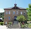 Animas City School |
April 23, 2019 (#100003687) |
3065 W. 2nd Ave. 37°17′57″N 107°52′23″W |
Durango | |
| 3 | Colorado Ute Power Plant | 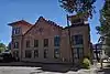 Colorado Ute Power Plant |
September 29, 1983 (#83001323) |
14th St. and the Animas River 37°16′44″N 107°52′47″W |
Durango | |
| 4 | Denver and Rio Grande Western Railroad Locomotive No. 315 | 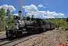 Denver and Rio Grande Western Railroad Locomotive No. 315 |
October 24, 2008 (#08001008) |
479 Main Ave. 37°16′05″N 107°52′57″W |
Durango | |
| 5 | Durango High School | 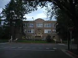 Durango High School |
October 20, 2001 (#01001119) |
201 E. 12th St. 37°16′36″N 107°52′39″W |
Durango | |
| 6 | Durango Rock Shelters Archeology Site | February 11, 1985 (#85000260) |
Address Restricted |
Durango | ||
| 7 | Durango-Silverton Narrow-Gauge Railroad | 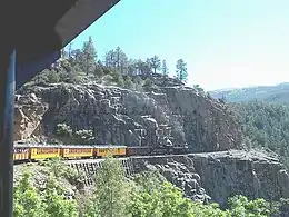 Durango-Silverton Narrow-Gauge Railroad |
October 15, 1966 (#66000247) |
Right-of-way between Durango and Silverton 37°17′51″N 107°42′39″W |
Durango | |
| 8 | East Third Avenue Historic Residential District | East Third Avenue Historic Residential District |
October 11, 1984 (#84000024) |
E. 3rd. Ave. between 5th and 15th Sts. 37°16′26″N 107°52′37″W |
Durango | |
| 9 | La Plata County Fairgrounds | 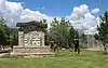 La Plata County Fairgrounds |
August 12, 1991 (#91001031) |
2500 Main Ave. 37°17′33″N 107°52′22″W |
Durango | |
| 10 | Main Avenue Historic District | 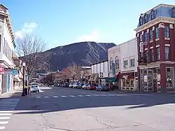 Main Avenue Historic District |
August 7, 1980 (#80000907) |
Main Ave. 37°16′23″N 107°52′48″W |
Durango | |
| 11 | Newman Block | 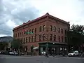 Newman Block |
October 15, 1979 (#79000613) |
801-813 Main Ave. 37°16′21″N 107°52′50″W |
Durango | |
| 12 | Ochsner Hospital | 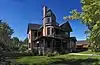 Ochsner Hospital |
May 4, 1995 (#95000534) |
805 5th Ave. 37°16′16″N 107°52′30″W |
Durango | |
| 13 | Rochester Hotel | 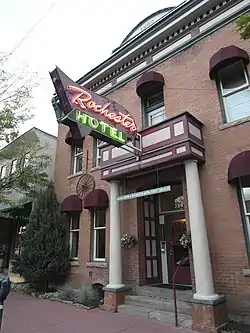 Rochester Hotel |
February 29, 1996 (#96000200) |
726 E. 2nd Ave. 37°16′17″N 107°52′44″W |
Durango | |
| 14 | Smiley Junior High School | 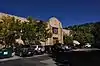 Smiley Junior High School |
November 27, 2002 (#02001462) |
1309 E. 3rd Ave. 37°16′39″N 107°52′34″W |
Durango | |
| 15 | Spring Creek Archeological District | May 21, 1983 (#83001322) |
Address Restricted |
Bayfield | ||
| 16 | Ute Mountain Ute Mancos Canyon Historic District | 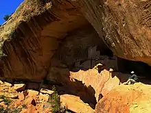 Ute Mountain Ute Mancos Canyon Historic District |
May 2, 1972 (#72000273) |
Address Restricted |
Durango |
See also
| Wikimedia Commons has media related to National Register of Historic Places in La Plata County, Colorado. |
References
- The latitude and longitude information provided in this table was derived originally from the National Register Information System, which has been found to be fairly accurate for about 99% of listings. Some locations in this table may have been corrected to current GPS standards.
- "National Register of Historic Places: Weekly List Actions". National Park Service, United States Department of the Interior. Retrieved on February 5, 2021.
- Numbers represent an alphabetical ordering by significant words. Various colorings, defined here, differentiate National Historic Landmarks and historic districts from other NRHP buildings, structures, sites or objects.
- "National Register Information System". National Register of Historic Places. National Park Service. July 9, 2010.
- The eight-digit number below each date is the number assigned to each location in the National Register Information System database, which can be viewed by clicking the number.
| Topics | |
|---|---|
| Lists by state |
|
| Lists by insular areas | |
| Lists by associated state | |
| Other areas | |
| Related | |
| |
Municipalities and communities of La Plata County, Colorado, United States | ||
|---|---|---|
| City | Map of Colorado highlighting La Plata County | |
| Towns | ||
| CDPs | ||
| Unincorporated communities | ||
| Indian reservations | ||
| Footnotes | ‡This populated place also has portions in an adjacent county or counties | |
| ||
This article is issued from Wikipedia. The text is licensed under Creative Commons - Attribution - Sharealike. Additional terms may apply for the media files.