National Register of Historic Places listings in San Juan County, Colorado
This is a list of the National Register of Historic Places listings in San Juan County, Colorado.
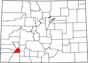
Location of San Juan County in Colorado
This is intended to be a complete list of the properties and districts on the National Register of Historic Places in San Juan County, Colorado, United States. The locations of National Register properties and districts for which the latitude and longitude coordinates are included below, may be seen in a map.[1]
There are 12 properties and districts listed on the National Register in the county.
- This National Park Service list is complete through NPS recent listings posted February 5, 2021.[2]
| Adams - Alamosa - Arapahoe - Archuleta - Baca - Bent - Boulder - Broomfield - Chaffee - Cheyenne - Clear Creek - Conejos - Costilla - Crowley - Custer - Delta - Denver - Dolores - Douglas - Eagle - El Paso - Elbert - Fremont - Garfield - Gilpin - Grand - Gunnison - Hinsdale - Huerfano - Jackson - Jefferson - Kiowa - Kit Carson - La Plata - Lake - Larimer - Las Animas - Lincoln - Logan - Mesa - Mineral - Moffat - Montezuma - Montrose - Morgan - Otero - Ouray - Park - Phillips - Pitkin - Prowers - Pueblo - Rio Blanco - Rio Grande - Routt - Saguache - San Juan - San Miguel - Sedgwick - Summit - Teller - Washington - Weld - Yuma |
Current listings
| [3] | Name on the Register[4] | Image | Date listed[5] | Location | City or town | Description |
|---|---|---|---|---|---|---|
| 1 | Animas Forks | 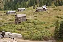 Animas Forks |
March 21, 2011 (#11000095) |
Address Restricted |
Silverton | |
| 2 | Cascade Boy Scout Camp | 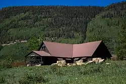 Cascade Boy Scout Camp |
September 8, 1988 (#88001529) |
Adjacent to Lime Creek Rd. in the San Juan National Forest 37°39′24″N 107°47′57″W |
Durango | See Scouting in New Mexico and Scouting in Colorado |
| 3 | Durango-Silverton Narrow-Gauge Railroad | 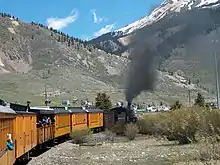 Durango-Silverton Narrow-Gauge Railroad |
October 15, 1966 (#66000247) |
Right-of-way between Durango and Silverton 37°17′51″N 107°42′39″W |
Silverton | |
| 4 | Frisco-Bagley Mine and Tunnel | June 1, 2020 (#100005235) |
820 Cty Rd. 9 37°55′57″N 107°34′52″W |
Silverton | ||
| 5 | Gold Prince Mine, Mill and Aerial Tramway | October 13, 2011 (#11000734) |
Address Restricted |
Silverton | ||
| 6 | Martin Mining Complex | May 5, 2004 (#04000384) |
6350 County Road 2 37°53′12″N 107°33′39″W |
Silverton | ||
| 7 | Minnie Gulch Cabins | March 21, 2011 (#11000096) |
Address Restricted |
Silverton | ||
| 8 | Placer Gulch Boarding House | March 21, 2011 (#11000094) |
Address Restricted |
Silverton | ||
| 9 | Shenandoah-Dives Mill | 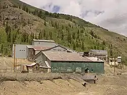 Shenandoah-Dives Mill |
February 16, 2000 (#00000262) |
State Highway 110, 2 miles northeast of Silverton 37°49′02″N 107°37′36″W |
Silverton | |
| 10 | Silverton Historic District | 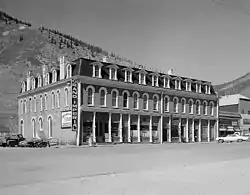 Silverton Historic District |
October 15, 1966 (#66000255) |
U.S. Highway 550; also roughly along State Highway 110 and the aerial tramway from Ladore Mine to Mayflower Mine 37°48′47″N 107°39′35″W |
Silverton | Second set of addresses represents a boundary increase |
| 11 | Sound Democrat Mill and Mine and Silver Queen Mine | 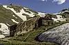 Sound Democrat Mill and Mine and Silver Queen Mine |
April 28, 2015 (#15000171) |
Address Restricted |
Silverton | |
| 12 | Tobasco Mine and Mill | October 16, 2008 (#08000983) |
South of San Juan County Road 5 and Hinsdale County Road 34 37°55′52″N 107°32′24″W |
San Juan | Extends into Hinsdale County |
See also
| Wikimedia Commons has media related to National Register of Historic Places in San Juan County, Colorado. |
References
- The latitude and longitude information provided in this table was derived originally from the National Register Information System, which has been found to be fairly accurate for about 99% of listings. Some locations in this table may have been corrected to current GPS standards.
- "National Register of Historic Places: Weekly List Actions". National Park Service, United States Department of the Interior. Retrieved on February 5, 2021.
- Numbers represent an alphabetical ordering by significant words. Various colorings, defined here, differentiate National Historic Landmarks and historic districts from other NRHP buildings, structures, sites or objects.
- "National Register Information System". National Register of Historic Places. National Park Service. July 9, 2010.
- The eight-digit number below each date is the number assigned to each location in the National Register Information System database, which can be viewed by clicking the number.
| Topics | |
|---|---|
| Lists by state |
|
| Lists by insular areas | |
| Lists by associated state | |
| Other areas | |
| Related | |
| |
Municipalities and communities of San Juan County, Colorado, United States | ||
|---|---|---|
| Town | Map of Colorado highlighting San Juan County | |
| Unincorporated communities | ||
| Ghost towns | ||
| ||
This article is issued from Wikipedia. The text is licensed under Creative Commons - Attribution - Sharealike. Additional terms may apply for the media files.