National Register of Historic Places listings in Gunnison County, Colorado
This is a list of the National Register of Historic Places listings in Gunnison County, Colorado.
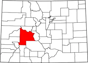
Location of Gunnison County in Colorado
This is intended to be a complete list of the properties and districts on the National Register of Historic Places in Gunnison County, Colorado, United States. The locations of National Register properties and districts for which the latitude and longitude coordinates are included below, may be seen in a map.[1]
There are 22 properties and districts listed on the National Register in the county.
- This National Park Service list is complete through NPS recent listings posted February 5, 2021.[2]
| Adams - Alamosa - Arapahoe - Archuleta - Baca - Bent - Boulder - Broomfield - Chaffee - Cheyenne - Clear Creek - Conejos - Costilla - Crowley - Custer - Delta - Denver - Dolores - Douglas - Eagle - El Paso - Elbert - Fremont - Garfield - Gilpin - Grand - Gunnison - Hinsdale - Huerfano - Jackson - Jefferson - Kiowa - Kit Carson - La Plata - Lake - Larimer - Las Animas - Lincoln - Logan - Mesa - Mineral - Moffat - Montezuma - Montrose - Morgan - Otero - Ouray - Park - Phillips - Pitkin - Prowers - Pueblo - Rio Blanco - Rio Grande - Routt - Saguache - San Juan - San Miguel - Sedgwick - Summit - Teller - Washington - Weld - Yuma |
Current listings
| [3] | Name on the Register[4] | Image | Date listed[5] | Location | City or town | Description |
|---|---|---|---|---|---|---|
| 1 | Alpine Tunnel Historic District | 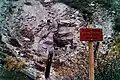 Alpine Tunnel Historic District |
April 1, 1996 (#80004632) |
Along the Denver, South Park and Pacific Railroad tracks from Quartz to Hancock 38°37′46″N 106°24′02″W |
Pitkin | First railroad tunnel over the Continental Divide, now sealed shut. |
| 2 | Chance Gulch Site | December 6, 2006 (#06001102) |
Address Restricted |
Gunnison | ||
| 3 | Crested Butte Denver and Rio Grande Railroad Depot | 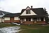 Crested Butte Denver and Rio Grande Railroad Depot |
May 10, 2001 (#01000444) |
716 Elk Ave. 38°52′11″N 106°58′41″W |
Crested Butte | |
| 4 | Crystal Mill | 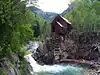 Crystal Mill |
July 5, 1985 (#85001493) |
County Road 3, 7 miles southeast of Marble 39°03′32″N 107°06′14″W |
Crystal | |
| 5 | Curecanti Archeological District | 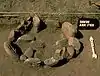 Curecanti Archeological District |
August 15, 1984 (#84000852) |
Curecanti National Recreation Area 38°28′14″N 107°18′05″W |
Gunnison | 5,000 acre area of the Curecanti National Recreation Area[6] |
| 6 | Edgerton House | 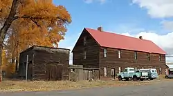 Edgerton House |
April 1, 1998 (#98000293) |
514 W. Gunnison Ave. 38°32′33″N 106°55′58″W |
Gunnison | |
| 7 | Fisher-Zugelder House and Smith Cottage | 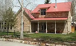 Fisher-Zugelder House and Smith Cottage |
January 5, 1984 (#84000853) |
601 N. Wisconsin St. 38°33′00″N 106°55′41″W |
Gunnison | |
| 8 | Gunnison River Bridge I | 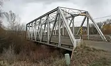 Gunnison River Bridge I |
October 15, 2002 (#02001152) |
U.S. Highway 50 service road at milepost 155.41 38°31′58″N 106°57′08″W |
Gunnison | Pratt through truss bridge spanning Gunnison River overflow |
| 9 | Gunnison River Bridge II | 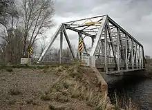 Gunnison River Bridge II |
October 15, 2002 (#02001151) |
U.S. Highway 50 service road at milepost 155.59 38°32′02″N 106°56′57″W |
Gunnison | Pratt through truss bridge spanning Gunnison River |
| 10 | Haxby House | 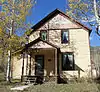 Haxby House |
April 4, 1996 (#96000355) |
101 W. Silver 39°04′22″N 107°11′16″W |
Marble | |
| 11 | Johnson Stage Station | August 28, 2017 (#16000667) |
2.2 mi. S. of the jct. of Cty. Rd. 64 & US 149 38°19′14″N 107°13′23″W |
Powderhorn vicinity | ||
| 12 | Marble City State Bank Building | 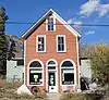 Marble City State Bank Building |
September 17, 1999 (#99001146) |
105 W. Main St. 39°04′19″N 107°11′17″W |
Marble | |
| 13 | Marble High School | 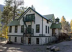 Marble High School |
August 3, 1989 (#89000989) |
412 Main St. 39°04′18″N 107°11′32″W |
Marble | |
| 14 | Marble Jailhouse | November 22, 2016 (#16000783) |
209 E. State St. 39°04′16″N 107°11′06″W |
Marble | ||
| 15 | Marble Mill Site |  Marble Mill Site |
February 7, 1979 (#79000610) |
Park and W. 3rd Sts. 39°04′09″N 107°11′31″W |
Marble | |
| 16 | Marble Town Hall |  Marble Town Hall |
August 3, 1989 (#89000988) |
407 Main St. 39°04′19″N 107°11′31″W |
Marble | |
| 17 | William D. Parry House | 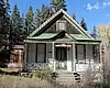 William D. Parry House |
August 3, 1989 (#89000987) |
115 Main St. 39°04′19″N 107°11′19″W |
Marble | |
| 18 | Rimrock School | 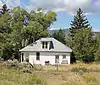 Rimrock School |
October 12, 2000 (#00001195) |
County Road 24 38°23′21″N 107°29′05″W |
Sapinero | |
| 19 | St. Paul's Church | 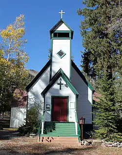 St. Paul's Church |
August 3, 1989 (#89000990) |
123 State St. 39°04′16″N 107°11′21″W |
Marble | |
| 20 | Town of Crested Butte | 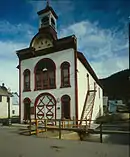 Town of Crested Butte |
May 29, 1974 (#74002279) |
Roughly bounded by Maroon Ave., 8th St., White Rock Ave., and 1st St.; also roughly bounded by Gothic Ave., 6th St., White Rock Ave., and 1st St. 38°52′12″N 106°58′39″W |
Crested Butte | Second set of addresses represents a boundary increase |
| 21 | Vienna Bakery-Johnson Restaurant | 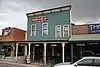 Vienna Bakery-Johnson Restaurant |
January 5, 2005 (#04001425) |
122-124 N. Main St. 38°32′42″N 106°55′34″W |
Gunnison | |
| 22 | Webster Building | 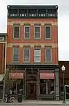 Webster Building |
May 17, 1984 (#84000857) |
229 N. Main St. 38°32′45″N 106°55′36″W |
Gunnison |
See also
| Wikimedia Commons has media related to National Register of Historic Places in Gunnison County, Colorado. |
References
- The latitude and longitude information provided in this table was derived originally from the National Register Information System, which has been found to be fairly accurate for about 99% of listings. Some locations in this table may have been corrected to current GPS standards.
- "National Register of Historic Places: Weekly List Actions". National Park Service, United States Department of the Interior. Retrieved on February 5, 2021.
- Numbers represent an alphabetical ordering by significant words. Various colorings, defined here, differentiate National Historic Landmarks and historic districts from other NRHP buildings, structures, sites or objects.
- "National Register Information System". National Register of Historic Places. National Park Service. July 9, 2010.
- The eight-digit number below each date is the number assigned to each location in the National Register Information System database, which can be viewed by clicking the number.
- "Archeology at Curecanti". National Park Service. Retrieved 2012-05-31.
| Topics | |
|---|---|
| Lists by state |
|
| Lists by insular areas | |
| Lists by associated state | |
| Other areas | |
| Related | |
| |
Municipalities and communities of Gunnison County, Colorado, United States | ||
|---|---|---|
| City | Map of Colorado highlighting Gunnison County | |
| Towns | ||
| CDP | ||
| Unincorporated communities | ||
| Ghost towns | ||
| ||
This article is issued from Wikipedia. The text is licensed under Creative Commons - Attribution - Sharealike. Additional terms may apply for the media files.