Franklin County, Indiana
Franklin County is a county on the eastern border of the U.S. state of Indiana. In the 2010 United States Census, the county population was 23,087.[1] The county seat is the town of Brookville.[2] Franklin County is part of the Cincinnati, OH–KY–IN Metropolitan Statistical Area. The only incorporated city in Franklin County is Batesville, which lies mostly in adjoining Ripley County.
Franklin County | |
|---|---|
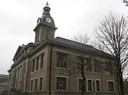 Franklin County Courthouse in Brookville Historic District | |
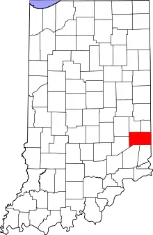 Location within the U.S. state of Indiana | |
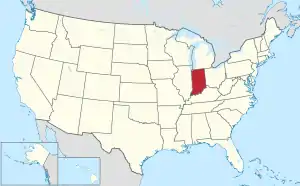 Indiana's location within the U.S. | |
| Coordinates: 39°25′N 85°04′W | |
| Country | |
| State | |
| Founded | 1 February 1811 (authorized) |
| Named for | Benjamin Franklin |
| Seat | Brookville |
| Largest town | Brookville (entirely within county) Batesville (partial) |
| Area | |
| • Total | 391.05 sq mi (1,012.8 km2) |
| • Land | 384.43 sq mi (995.7 km2) |
| • Water | 6.62 sq mi (17.1 km2) 1.69%% |
| Population | |
| • Estimate (2018) | 22,736 |
| • Density | 59.1/sq mi (22.8/km2) |
| Time zone | UTC−5 (Eastern) |
| • Summer (DST) | UTC−4 (EDT) |
| Congressional district | 6th |
| Website | www |
| Indiana county number 24 | |
Geography
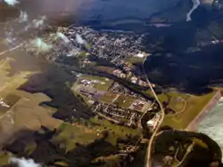
Franklin County lies on the eastern edge of Indiana; its eastern border abuts the western border of Ohio. Its low rolling hills, once completely wooded, have been partially cleared and leveled for agricultural use. The carved drainages are still largely brush-filled.[3] According to the 2010 census, the county has a total area of 391.05 square miles (1,012.8 km2), of which 384.43 square miles (995.7 km2) (or 98.31%) is land and 6.62 square miles (17.1 km2) (or 1.69%) is water.[4]
Brookville Lake extends into the county's northern part, formed by a dam of the same name on the East Branch of the Whitewater River, a tributary of the Great Miami River. The West Branch of the Whitewater River enters the county's northwestern part from Fayette County and joins the east branch at Brookville, to form the Whitewater River, flowing southeastward into Dearborn County. The southern and southwestern parts of Franklin County are drained by Salt Creek, Pipe Creek, and Blue Creek, which flow northeastward into Whitewater River.[3] The highest point in the county (1,070 feet/326 meters ASL) is a small hill 1.0 mile (1.6 km) north of Andersonville.[5]
Adjacent counties
- Fayette County - north
- Union County - northeast
- Butler County, Ohio - east
- Hamilton County, Ohio - southeast
- Dearborn County - south
- Ripley County - southwest
- Decatur County - west
- Rush County - northwest
Major highways
Protected areas
- Mounds State Recreation Area[3]
Lakes
- Brookville Lake (part)
Communities
City
- Batesville (partial)
Towns
- Brookville (county seat)
- Cedar Grove
- Laurel
- Mount Carmel
- Oldenburg
- West Harrison (partial)
Census-designated places
- Lake Santee (partial)
- Metamora
- New Trenton
Unincorporated communities
- Andersonville
- Bath
- Blooming Grove
- Buena Vista
- Drewersburg
- Enochsburg
- Fairfield (extinct)
- Hamburg
- Highland Center
- Huntersville
- Klemmes Corner
- Lake View
- Midway
- Millville
- Mixersville
- Mound Haven
- Mount Auburn
- New Fairfield
- Oak Forest
- Old Bath
- Palestine
- Peoria
- Peppertown
- Raymond
- Rockdale
- Saint Marys
- Saint Peter
- Scipio (part)
- Sharptown
- South Gate
- Stavetown
- Whitcomb
- Yellow Bank
- Youngs Corner
History
The future state of Indiana was first regulated by congressional passage of the Northwest Ordinance in 1787. In 1790 the Territory was divided into two counties, with Knox covering much of present-day Indiana. In 1810, a portion of Knox was partitioned to create Wayne County, and shortly thereafter a portion further south was partitioned to create Franklin; the authorizing act was dated 1 February 1811. It was named for statesman Benjamin Franklin.[6][7]
Some early settlers of Franklin County were Primitive Baptists who came with Elder William Tyner from Virginia in 1797, after the American Revolutionary War. They organized the first church congregation in the Whitewater Valley, the Little Cedar Grove Baptist Church.[8] They raised a log chapel southeast of Brookville in 1805.
Another European-American landmark is the Big Cedar Baptist Church and Burying Ground on Big Cedar Creek Road, between the road to Reily and the Oxford Pike. The original church was established in 1817, as an arm of the Little Cedar Baptist church. The brick building was built in 1838. This church congregation, similar to many pioneer Baptist groups in the country, was originally Primitive Baptist or Hardshell. In the 1830s modernism reached the county, bringing innovations such as Sunday schools, Missionary Societies, and the playing of organs. Organs were particularly anathema to the Primitive Party, who considered it akin to Aaron's golden calf.
The Big Cedar congregation divided into two over themse issues, but the two groups arrived at an amicable settlement. Both congregations continued to use the same building: the Primitives, or Hardshells, had worship in the church on the first and third Sabbath of each month, and the Modernists or Missionary Baptists used the church on the second and fourth Sundays. Each congregation had a wood shed. The building is now maintained in connection with the Big Cedar Cemetery Association.[9]
Governors James B. Ray, Noah Noble and David Wallace were known as the "Brookville Triumvirate." They had each lived in Brookville and were elected to consecutive terms as Indiana governor. Noble and Ray were political adversaries.[10]
James B. Goudie Jr. (1769-1836), Speaker of the Indiana House, was also from Franklin County.
Climate and weather
| Brookville, Indiana | ||||||||||||||||||||||||||||||||||||||||||||||||||||||||||||
|---|---|---|---|---|---|---|---|---|---|---|---|---|---|---|---|---|---|---|---|---|---|---|---|---|---|---|---|---|---|---|---|---|---|---|---|---|---|---|---|---|---|---|---|---|---|---|---|---|---|---|---|---|---|---|---|---|---|---|---|---|
| Climate chart (explanation) | ||||||||||||||||||||||||||||||||||||||||||||||||||||||||||||
| ||||||||||||||||||||||||||||||||||||||||||||||||||||||||||||
| ||||||||||||||||||||||||||||||||||||||||||||||||||||||||||||
In recent years, average temperatures in Brookville have ranged from a low of 17 °F (−8 °C) in January to a high of 87 °F (31 °C) in July, although a record low of −31 °F (−35 °C) was recorded in January 1994 and a record high of 104 °F (40 °C) was recorded in September 1951. Average monthly precipitation ranged from 2.68 inches (68 mm) in September to 4.90 inches (124 mm) in May.[11]
Government
The county government is a constitutional body, and is granted specific powers by the Constitution of Indiana, and by the Indiana Code.
County Council: The legislative branch of the county government; controls spending and revenue collection in the county. Representatives are elected to four-year terms from county districts. They set salaries, the annual budget, and special spending. The council has limited authority to impose local taxes, in the form of an income and property tax that is subject to state level approval, excise taxes, and service taxes.[12][13]
Board of Commissioners: The executive body of the county; commissioners are elected county-wide to staggered four-year terms. One commissioner serves as president. The commissioners execute acts legislated by the council, collect revenue, and manage county government.[12][13]
County Officials: The county has other elected offices, including sheriff, coroner, auditor, treasurer, recorder, surveyor, and circuit court clerk. These officers are elected to four-year terms. Members elected to county government positions are required to declare party affiliations and to be residents of the county.[13]
Franklin County is part of Indiana's 6th congressional district; Indiana Senate districts 42 and 43;[14] and Indiana House of Representatives districts 55, 67 and 68.[15]
| Year | Republican | Democratic | Third parties |
|---|---|---|---|
| 2016 | 78.7% 8,669 | 17.9% 1,969 | 3.4% 375 |
| 2012 | 70.2% 7,424 | 27.5% 2,909 | 2.3% 247 |
| 2008 | 66.0% 7,018 | 32.0% 3,404 | 2.1% 220 |
| 2004 | 69.8% 6,977 | 29.3% 2,925 | 0.9% 90 |
| 2000 | 67.0% 5,587 | 31.1% 2,591 | 1.9% 161 |
| 1996 | 52.3% 4,167 | 35.2% 2,808 | 12.5% 1,000 |
| 1992 | 46.9% 3,831 | 30.1% 2,456 | 23.0% 1,880 |
| 1988 | 65.7% 4,777 | 34.0% 2,472 | 0.3% 22 |
| 1984 | 69.6% 5,202 | 29.8% 2,225 | 0.6% 45 |
| 1980 | 59.1% 4,551 | 36.8% 2,834 | 4.1% 316 |
| 1976 | 52.0% 3,557 | 47.3% 3,234 | 0.8% 54 |
| 1972 | 66.7% 4,324 | 32.9% 2,131 | 0.4% 24 |
| 1968 | 52.3% 3,468 | 36.0% 2,386 | 11.8% 780 |
| 1964 | 42.3% 2,956 | 57.5% 4,021 | 0.3% 18 |
| 1960 | 53.7% 4,108 | 46.1% 3,523 | 0.2% 14 |
| 1956 | 63.0% 4,429 | 36.6% 2,573 | 0.4% 26 |
| 1952 | 64.0% 4,630 | 35.2% 2,548 | 0.7% 52 |
| 1948 | 55.1% 3,566 | 44.2% 2,860 | 0.7% 42 |
| 1944 | 59.8% 3,796 | 39.9% 2,530 | 0.3% 20 |
| 1940 | 58.1% 4,381 | 41.7% 3,142 | 0.2% 16 |
| 1936 | 41.2% 2,952 | 54.3% 3,891 | 4.5% 321 |
| 1932 | 36.0% 2,687 | 63.1% 4,704 | 0.9% 68 |
| 1928 | 47.2% 3,426 | 52.6% 3,817 | 0.2% 17 |
| 1924 | 44.4% 3,296 | 52.8% 3,915 | 2.8% 207 |
| 1920 | 45.5% 3,137 | 53.3% 3,671 | 1.2% 85 |
| 1916 | 37.2% 1,495 | 60.4% 2,426 | 2.3% 94 |
| 1912 | 23.4% 929 | 58.0% 2,306 | 18.6% 741 |
| 1908 | 38.2% 1,670 | 59.9% 2,616 | 1.9% 82 |
| 1904 | 40.4% 1,757 | 57.5% 2,501 | 2.2% 95 |
| 1900 | 38.1% 1,738 | 61.0% 2,781 | 0.9% 43 |
| 1896 | 38.1% 1,760 | 61.5% 2,844 | 0.4% 19 |
| 1892 | 35.5% 1,610 | 63.0% 2,859 | 1.5% 70 |
| 1888 | 37.1% 1,712 | 62.2% 2,872 | 0.8% 37 |
Demographics
| Historical population | |||
|---|---|---|---|
| Census | Pop. | %± | |
| 1820 | 10,763 | — | |
| 1830 | 10,190 | −5.3% | |
| 1840 | 13,349 | 31.0% | |
| 1850 | 17,968 | 34.6% | |
| 1860 | 19,549 | 8.8% | |
| 1870 | 20,223 | 3.4% | |
| 1880 | 20,092 | −0.6% | |
| 1890 | 18,366 | −8.6% | |
| 1900 | 16,388 | −10.8% | |
| 1910 | 15,335 | −6.4% | |
| 1920 | 14,806 | −3.4% | |
| 1930 | 14,498 | −2.1% | |
| 1940 | 14,412 | −0.6% | |
| 1950 | 16,034 | 11.3% | |
| 1960 | 17,015 | 6.1% | |
| 1970 | 16,943 | −0.4% | |
| 1980 | 19,612 | 15.8% | |
| 1990 | 19,580 | −0.2% | |
| 2000 | 22,151 | 13.1% | |
| 2010 | 23,087 | 4.2% | |
| 2018 (est.) | 22,736 | [17] | −1.5% |
| US Decennial Census[18] 1790–1960[19] 1900–1990[20] 1990–2000[21] 2010–2013[1] | |||
2010 Census
As of the 2010 United States Census, there were 23,087 people, 8,579 households, and 6,447 families in the county.[22] The population density was 60.1 inhabitants per square mile (23.2/km2). There were 9,538 housing units at an average density of 24.8 per square mile (9.6/km2).[4] The racial makeup of the county was 98.3% white, 0.2% black or African American, 0.2% Asian, 0.1% American Indian, 0.3% from other races, and 0.8% from two or more races. Those of Hispanic or Latino origin made up 0.9% of the population.[22] In terms of ancestry, 40.3% were German, 14.7% were American, 13.1% were Irish, and 9.5% were English.[23]
Of the 8,579 households, 35.9% had children under the age of 18 living with them, 61.6% were married couples living together, 8.4% had a female householder with no husband present, 24.9% were non-families, and 20.5% of all households were made up of individuals. The average household size was 2.67 and the average family size was 3.07. The median age was 40.0 years.[22]
The median income for a household in the county was $47,697 and the median income for a family was $60,300. Males had a median income of $43,443 versus $32,612 for females. The per capita income for the county was $23,090. About 8.6% of families and 11.7% of the population were below the poverty line, including 16.8% of those under age 18 and 10.9% of those age 65 or over.[24]
References
- "Franklin County QuickFacts". US Census Bureau. Archived from the original on 7 June 2011. Retrieved 17 September 2011.
- "Find a County". National Association of Counties. Archived from the original on 31 May 2011. Retrieved 7 June 2011.
- Franklin County IN (Google Maps, accessed 8 August 2020)
- "Population, Housing Units, Area, and Density: 2010 – County". US Census Bureau. Archived from the original on 12 February 2020. Retrieved 10 July 2015.
- Franklin County High Point, Indiana (PeakBagger.com, accessed 8 August 2020)
- De Witt Clinton Goodrich & Charles Richard Tuttle (1875). An Illustrated History of the State of Indiana. Indiana: R. S. Peale & co. p. 558.
- Gannett, Henry (1905). The Origin of Certain Place Names in the United States. Govt. Print. Off. p. 131.
- "Archived copy". Archived from the original on 15 May 2006. Retrieved 9 May 2006.CS1 maint: archived copy as title (link)
- "Archived copy". Archived from the original on 20 September 2007. Retrieved 30 August 2007.CS1 maint: archived copy as title (link)
- "Archived copy". Archived from the original on 11 March 2007. Retrieved 11 July 2006.CS1 maint: archived copy as title (link)
- "Monthly Averages for Brookville IN". The Weather Channel. Retrieved 27 January 2011.
- Indiana Code. "Title 36, Article 2, Section 3". IN.gov. Retrieved 16 September 2008.
- Indiana Code. "Title 2, Article 10, Section 2" (PDF). IN.gov. Retrieved 16 September 2008.
- "Indiana Senate Districts". State of Indiana. Retrieved 23 January 2011.
- "Indiana House Districts". State of Indiana. Retrieved 23 January 2011.
- Leip, David. "Atlas of US Presidential Elections". uselectionatlas.org. Retrieved 14 May 2018.
- "Population and Housing Unit Estimates". Retrieved July 26, 2019.
- "US Decennial Census". US Census Bureau. Retrieved July 10, 2014.
- "Historical Census Browser". University of Virginia Library. Retrieved July 10, 2014.
- "Population of Counties by Decennial Census: 1900 to 1990". US Census Bureau. Retrieved July 10, 2014.
- "Census 2000 PHC-T-4. Ranking Tables for Counties: 1990 and 2000" (PDF). US Census Bureau. Retrieved July 10, 2014.
- "Profile of General Population and Housing Characteristics: 2010 Demographic Profile Data". US Census Bureau. Archived from the original on 13 February 2020. Retrieved 10 July 2015.
- "Selected Social Characteristics in the US – 2006–2010 American Community Survey 5-Year Estimates". US Census Bureau. Archived from the original on 14 February 2020. Retrieved 10 July 2015.
- "Selected Economic Characteristics – 2006–2010 American Community Survey 5-Year Estimates". US Census Bureau. Archived from the original on 14 February 2020. Retrieved 10 July 2015.
Places adjacent to Franklin County, Indiana | ||||||||||
|---|---|---|---|---|---|---|---|---|---|---|
| ||||||||||
Municipalities and communities of Franklin County, Indiana, United States | ||
|---|---|---|
| City | Map of Indiana highlighting Franklin County | |
| Towns | ||
| Townships | ||
| CDPs | ||
| Other unincorporated communities |
| |
| Footnotes | ‡This populated place also has portions in an adjacent county or counties | |
| ||

| Authority control |
|---|