Benton County, Indiana
Benton County is located in the northwest part of the U.S. state of Indiana, along the border with Illinois. As of 2010, the county's population was 8,854.[1] It contains six incorporated towns as well as several small unincorporated settlements; it is divided into 11 townships which provide local services.[2][3] The county seat is Fowler.[4]
Benton County | |
|---|---|
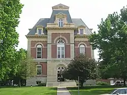 Benton County Courthouse in Fowler, Indiana. | |
 Flag | |
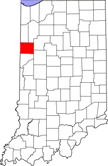 Location within the U.S. state of Indiana | |
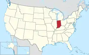 Indiana's location within the U.S. | |
| Coordinates: 40°37′N 87°19′W | |
| Country | |
| State | |
| Founded | 18 February 1840 |
| Named for | Senator Thomas H. Benton |
| Seat | Fowler |
| Largest city | Fowler |
| Area | |
| • Total | 406.51 sq mi (1,052.9 km2) |
| • Land | 406.42 sq mi (1,052.6 km2) |
| • Water | 0.09 sq mi (0.2 km2) 0.02%% |
| Population | |
| • Estimate (2018) | 8,653 |
| • Density | 21.3/sq mi (8.22/km2) |
| Time zone | UTC−5 (Eastern) |
| • Summer (DST) | UTC−4 (EDT) |
| Congressional district | 4th |
| Website | www |
| |
Benton County is part of the Lafayette, Indiana, Metropolitan Statistical Area.

History
The lands of present NW Indiana were explored by French explorer Robert de LaSalle. At that time the area was inhabited by the Miami Confederation of Indians. Through White settlement, encroachment, and confrontation, the various indigenous groups were forced to cede their claim to the area. In October 1818, the Pottawattamies, Weas, and Delawares ceded their lands west of the Tippecanoe River to the government. In a treaty dated 23 October 1826, the Pottawattamies and Miamis ceded all their lands east of the Tippecanoe. A treaty dated 26 October 1832 with the Pottawattamies ceded control of the northwestern part of Indiana; on 27 October the Pottawattamies of Indiana and Michigan also relinquished all claim to any remaining land in those states.
Before 1832 this area was not open to settlement; previous settlers had taken the southern parts of Ohio, Indiana and Illinois. Northwestern Indiana was also less desirable for farming, being described as alternate swamps, sterile sand ridges and flat, wet prairies, although it did proliferate in game.
A state legislative act dated 7 February 1835 created two counties in this area, Newton and Jasper. The county governments were not created at that time and the counties were attached to White County for administrative purposes. The Jasper County organizated was effected beginning 15 March 1838. On 18 February 1840, the county of Benton was formed from Jasper's area. It was named for Thomas H. Benton (D), U.S. Senator from Missouri.[5] The original county seat selected in 1843 was Oxford, but after a long struggle between contending factions it was moved to Fowler in 1874.[6]
Courthouse
The current Benton County courthouse, located in Fowler, was designed by Gordon P. Randall of Chicago and built in 1874 by Levi L. Leach at a cost of $62,257.[n 1] The new courthouse was an impressive building from an architectural standpoint, but also provided much-needed improvements in security, including large fire-proof vaults. Randall had designed the Marshall County courthouse a few years earlier.[8]
Economy
In 2008 the Benton County Wind Farm began operating with 87 1.5 MW wind turbines.[9] Duke Energy purchases electricity from the wind farm and sells it to customers through its GoGreen program.[10]
In 2009 the Fowler Ridge Wind Farm opened nearby,[11] giving Benton County one of the largest concentrations of wind turbines in the United States east of the Mississippi River.
Geography
Benton County lies along the state's western border with Illinois. It consists of low rolling hills, with all available terrain devoted to agriculture or development. Data gathered from space shuttle measurements list the county's lowest elevation as 138 meters (453 feet) and its highest elevation as 240 meters (787 feet).[12] However, a knoll 4 miles (6.4 km) NNW of Boswell is shown on official topographic maps as 915 feet (279 meters) ASL.[13]
According to the 2010 census, the county has a total area of 406.51 square miles (1,052.9 km2), of which 406.42 square miles (1,052.6 km2) (or 99.98%) is land and 0.09 square miles (0.23 km2) (or 0.02%) is water.[14]
Adjacent counties
- Newton County - northwest
- Jasper County - northeast
- White County - east
- Tippecanoe County - southeast
- Warren County - south
- Vermilion County, Illinois - southwest
- Iroquois County, Illinois - west
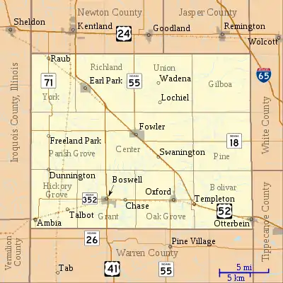
Unincorporated towns
Major highways
 U.S. Route 52
 U.S. Route 41
 State Road 18
 State Road 55
 State Road 71
 State Road 352
Education
The county's four public schools are administered by the Benton Community School Corporation.
- Benton Central Junior-Senior High School Benton Central
- Boswell Elementary School Boswell Elementary
- Otterbein Elementary School Otterbein Elementary
- Prairie Crossing Elementary School Prairie Crossing Elementary
- Sacred Heart Elementary in Fowler is the county's only parochial school.
Climate and weather
| Fowler, Indiana | ||||||||||||||||||||||||||||||||||||||||||||||||||||||||||||
|---|---|---|---|---|---|---|---|---|---|---|---|---|---|---|---|---|---|---|---|---|---|---|---|---|---|---|---|---|---|---|---|---|---|---|---|---|---|---|---|---|---|---|---|---|---|---|---|---|---|---|---|---|---|---|---|---|---|---|---|---|
| Climate chart (explanation) | ||||||||||||||||||||||||||||||||||||||||||||||||||||||||||||
| ||||||||||||||||||||||||||||||||||||||||||||||||||||||||||||
| ||||||||||||||||||||||||||||||||||||||||||||||||||||||||||||
In recent years, average temperatures in Fowler have ranged from a low of 13 °F (−11 °C) in January to a high of 84 °F (29 °C) in July, although a record low of −24 °F (−31 °C) was recorded in January 1999 and a record high of 99 °F (37 °C) was recorded in July 1995. Average monthly precipitation ranged from 1.59 inches (40 mm) in February to 4.50 inches (114 mm) in June.[15]
Government
The county government is a constitutional body granted specific powers by the Constitution of Indiana and the Indiana Code. The county council is the legislative branch of the county government, controlling spending and revenue collection. Representatives, elected to staggered four-year terms from county districts, determine salaries, the annual budget and special spending. The council has limited authority to impose local taxes, in the form of an income and property tax that is subject to state level approval, excise taxes and service taxes.[16][17] In 2010, the county budgeted approximately $5 million for the district's schools and $2.8 million for other county operations and services, for a total annual budget of approximately $7.8 million.[18]
The Board of Commissioners is the county's executive body. They are elected countywide, in staggered four-year terms. One commissioner serves as Board President. The commissioners execute acts legislated by the council, collecting revenue and managing day-to-day functions of the county government.[16][17]
The county maintains a small claims court that can handle some civil cases. The court judge is elected to a term of four years and must be a member of the Indiana Bar Association. The judge is assisted by a constable who is elected to a four-year term. In some cases, court decisions can be appealed to the state level circuit court.[17]
The county has several other elected offices, including sheriff, coroner, auditor, treasurer, recorder, surveyor and circuit court clerk. They are elected to four-year terms. Members elected to county government positions are required to declare party affiliations and be residents of the county.[17]
Each township has a trustee who administers rural fire protection and ambulance service, provides poor relief and manages cemetery care, among other duties.[3] The trustee is assisted in these duties by a three-member township board. The trustees and board members are elected to four-year terms.[19]
Benton County is in Indiana's 4th Congressional District, represented by Jim Baird in the United States Congress. It is part of Indiana Senate district 6[20] and Indiana House of Representatives district 13.[21] It had previously been part of House District 15.[22]
| Year | Republican | Democratic | Third parties |
|---|---|---|---|
| 2016 | 69.9% 2,579 | 23.3% 860 | 6.8% 249 |
| 2012 | 65.1% 2,329 | 32.4% 1,159 | 2.5% 90 |
| 2008 | 57.2% 2,183 | 41.0% 1,563 | 1.9% 71 |
| 2004 | 70.1% 2,797 | 28.4% 1,135 | 1.5% 60 |
| 2000 | 63.0% 2,441 | 34.3% 1,328 | 2.7% 105 |
| 1996 | 49.9% 1,947 | 33.6% 1,311 | 16.5% 642 |
| 1992 | 47.0% 2,030 | 28.2% 1,221 | 24.8% 1,072 |
| 1988 | 66.3% 2,698 | 33.2% 1,349 | 0.5% 22 |
| 1984 | 70.4% 3,281 | 29.1% 1,357 | 0.5% 24 |
| 1980 | 64.3% 3,189 | 30.6% 1,520 | 5.1% 254 |
| 1976 | 59.1% 3,093 | 39.6% 2,071 | 1.3% 70 |
| 1972 | 70.0% 3,703 | 29.6% 1,566 | 0.4% 20 |
| 1968 | 59.5% 3,326 | 33.2% 1,854 | 7.3% 406 |
| 1964 | 49.5% 2,886 | 50.4% 2,940 | 0.1% 5 |
| 1960 | 60.1% 3,626 | 39.8% 2,399 | 0.1% 7 |
| 1956 | 67.0% 4,004 | 32.8% 1,961 | 0.2% 9 |
| 1952 | 69.3% 4,125 | 30.5% 1,815 | 0.3% 17 |
| 1948 | 57.9% 3,224 | 41.6% 2,317 | 0.5% 29 |
| 1944 | 63.4% 3,621 | 36.2% 2,065 | 0.5% 27 |
| 1940 | 57.6% 3,675 | 42.1% 2,689 | 0.3% 20 |
| 1936 | 47.2% 2,989 | 50.7% 3,211 | 2.1% 131 |
| 1932 | 40.7% 2,433 | 58.4% 3,496 | 0.9% 54 |
| 1928 | 58.4% 3,360 | 41.1% 2,368 | 0.5% 28 |
| 1924 | 58.1% 3,250 | 37.6% 2,104 | 4.2% 236 |
| 1920 | 64.1% 3,900 | 34.5% 2,098 | 1.4% 83 |
| 1916 | 54.2% 1,872 | 43.5% 1,502 | 2.4% 82 |
| 1912 | 30.4% 1,030 | 42.1% 1,425 | 27.5% 931 |
| 1908 | 53.5% 1,936 | 43.3% 1,566 | 3.3% 118 |
| 1904 | 56.6% 2,098 | 39.7% 1,470 | 3.8% 139 |
| 1900 | 55.0% 2,032 | 42.3% 1,563 | 2.7% 101 |
| 1896 | 55.1% 1,998 | 43.7% 1,582 | 1.2% 44 |
| 1892 | 50.8% 1,617 | 43.7% 1,391 | 5.5% 174 |
| 1888 | 52.2% 1,626 | 45.7% 1,425 | 2.1% 65 |
Demographics
| Historical population | |||
|---|---|---|---|
| Census | Pop. | %± | |
| 1850 | 1,144 | — | |
| 1860 | 2,809 | 145.5% | |
| 1870 | 5,615 | 99.9% | |
| 1880 | 11,108 | 97.8% | |
| 1890 | 11,903 | 7.2% | |
| 1900 | 13,123 | 10.2% | |
| 1910 | 12,688 | −3.3% | |
| 1920 | 12,206 | −3.8% | |
| 1930 | 11,886 | −2.6% | |
| 1940 | 11,117 | −6.5% | |
| 1950 | 11,462 | 3.1% | |
| 1960 | 11,912 | 3.9% | |
| 1970 | 11,262 | −5.5% | |
| 1980 | 10,218 | −9.3% | |
| 1990 | 9,441 | −7.6% | |
| 2000 | 9,421 | −0.2% | |
| 2010 | 8,854 | −6.0% | |
| 2018 (est.) | 8,653 | [24] | −2.3% |
| US Decennial Census[25] 1790-1960[26] 1900-1990[27] 1990-2000[28] 2010-2013[1] | |||
As of the 2010 United States Census, there were 8,854 people, 3,479 households, and 2,388 families in the county.[29] The population density was 21.8 inhabitants per square mile (8.4/km2). There were 3,937 housing units at an average density of 9.7 per square mile (3.7/km2).[14] The racial makeup of the county was 95.9% white, 0.5% black or African American, 0.2% Asian, 0.1% American Indian, 2.2% from other races, and 1.1% from two or more races. Those of Hispanic or Latino origin made up 4.9% of the population.[29] In terms of ancestry, 32.4% were German, 17.0% were Irish, 11.3% were American, and 8.7% were English.[30]
Of the 3,479 households, 32.5% had children under the age of 18 living with them, 54.8% were married couples living together, 9.4% had a female householder with no husband present, 31.4% were non-families, and 27.0% of all households were made up of individuals. The average household size was 2.52 and the average family size was 3.06. The median age was 40.1 years.[29]
The median income for a household in the county was $47,697 and the median income for a family was $58,661. Males had a median income of $40,234 versus $27,957 for females. The per capita income for the county was $21,949. About 7.6% of families and 10.0% of the population were below the poverty line, including 13.6% of those under age 18 and 5.4% of those age 65 or over.[31]
Notes
- A $62,257 capital expense in 1874 would be roughly equivalent to $15,000,000 in 2009.[7]
References
- "Benton County QuickFacts". US Census Bureau. Archived from the original on 7 July 2011. Retrieved 17 September 2011.
- "Benton". Indiana Township Association. Archived from the original on 21 September 2010. Retrieved 12 September 2010.
- "Duties". United Township Association of Indiana. Retrieved 6 January 2011.
- "Find a County – Benton County IN". National Association of Counties. Archived from the original on 19 July 2011. Retrieved 6 January 2011.
- Baker, Ronald L.; Carmony, Marvin (1975). Indiana Place Names. Bloomington IN: Indiana University Press. p. 12.
- De Witt Clinton Goodrich & Charles Richard Tuttle (1875). An Illustrated History of the State of Indiana. Indiana: R. S. Peale & co. pp. 551–552.
- Williamson, Samuel H. (April 2010). Seven Ways to Compute the Relative Value of a U.S. Dollar Amount, 1774 to present. MeasuringWorth. Calculations made using Nominal GDP Per Capita, a measure of capital intensivity, using "the 'average' per-person output of the economy in the prices of the current year." This is a measure of the amount of capital and volume of labor required to reproduce the work over varying production methods, but assuming that money represents a proportion of the economy.
- Counts, Will; Jon Dilts (1991). The 92 Magnificent Indiana Courthouses. Bloomington IN: Indiana University Press. pp. 14–15. ISBN 978-0-253-33638-5.
- "Benton County Wind Farms". Archived from the original on 5 June 2009. Retrieved 21 June 2009.
- "Duke Energy's GoGreen Power". Duke Energy. Retrieved 21 June 2009.
- "US Wind Energy Projects - Indiana". American Wind Energy Association. 31 March 2009. Archived from the original on September 18, 2010. Retrieved 20 June 2009.
- Free Benton County, Indiana Topo Maps & Elevations (AnyPlace America, accessed 4 July 2020)
- Benton County High Point (PeakBagger.com, accessed 4 July 2020)
- "Population, Housing Units, Area, and Density: 2010 - County". US Census Bureau. Archived from the original on 12 February 2020. Retrieved 10 July 2015.
- "Monthly Averages for Fowler IN". The Weather Channel. Retrieved 27 January 2011.
- Indiana Code. "Title 36, Article 2, Section 3". Government of Indiana. Retrieved 16 September 2008.
- Indiana Code. "Title 2, Article 10, Section 2" (PDF). Government of Indiana. Retrieved 16 September 2008.
- State of Indiana Department of Local Government Finance. "2010 Budget Order (Benton County)" (PDF). Retrieved 19 February 2011.
- "Government". United Township Association of Indiana. Retrieved 6 January 2011.
- "Indiana Senate Districts". State of Indiana. Retrieved 2011-01-23.
- House District Map 2020 (accessed 4 July 2020)
- "Indiana House Districts". State of Indiana. Retrieved 23 January 2011.
- Leip, David. "Atlas of US Presidential Elections". uselectionatlas.org. Retrieved 11 April 2018.
- "Population and Housing Unit Estimates". Retrieved July 26, 2019.
- "US Decennial Census". US Census Bureau. Retrieved July 10, 2014.
- "Historical Census Browser". University of Virginia Library. Retrieved July 10, 2014.
- "Population of Counties by Decennial Census: 1900 to 1990". US Census Bureau. Retrieved July 10, 2014.
- "Census 2000 PHC-T-4. Ranking Tables for Counties: 1990 and 2000" (PDF). US Census Bureau. Retrieved July 10, 2014.
- "Profile of General Population and Housing Characteristics: 2010 Demographic Profile Data". US Census Bureau. Archived from the original on 13 February 2020. Retrieved 10 July 2015.
- "Selected Social Characteristics in the US – 2006-2010 American Community Survey 5-Year Estimates". US Census Bureau. Archived from the original on 14 February 2020. Retrieved 10 July 2015.
- "Selected Economic Characteristics – 2006-2010 American Community Survey 5-Year Estimates". US Census Bureau. Archived from the original on 14 February 2020. Retrieved 10 July 2015.
Bibliography
- Goodspeed, Weston A. (1883). "Part III. History of Benton County". Counties of Warren, Benton, Jasper and Newton, Indiana. Chicago: F. A. Battey and Company. pp. 213–407. Retrieved 19 September 2010.
External links
| Wikimedia Commons has media related to Benton County, Indiana. |
Places adjacent to Benton County, Indiana | |
|---|---|
Municipalities and communities of Benton County, Indiana, United States | ||
|---|---|---|
| Towns | Map of Indiana highlighting Benton County | |
| Townships | ||
| Unincorporated communities | ||
| Ghost towns | ||
| Footnotes | ‡This populated place also has portions in an adjacent county or counties | |
| ||

| Authority control |
|---|