LaPorte County, Indiana
LaPorte County[7] is a county located in the U.S. state of Indiana. As of 2010, the population was 111,467.[8] The county seat is the city of La Porte,[9] and the largest city is Michigan City.
LaPorte County, Indiana | |
|---|---|
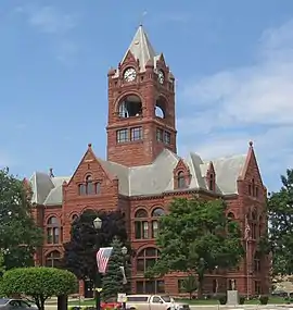 LaPorte County Courthouse in La Porte, Indiana | |
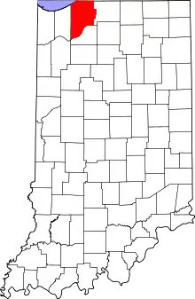 Location in the state of Indiana | |
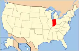 Indiana's location in the U.S. | |
| Coordinates: 41°36′N 86°43′W | |
| Country | |
| State | |
| Regions | Northwest Indiana and Michiana |
| Metro area | Chicago Metropolitan |
| Established | April 1, 1832 |
| Named for | "The Door" or "The Port" (fr.)[1] |
| County seat | La Porte |
| Largest city | Michigan City (population and total area) |
| Incorporated municipalities | 11 cities and towns
|
| Government | |
| • Type | County |
| • Body | Board of Commissioners |
| • Commissioner | Sheila Matias (D, 1st) |
| • Commissioner | Richard Mrozinksi (R, 2nd) |
| • Commissioner | Joe Haney (R, 3rd) |
| • County Council | |
| Area | |
| • County | 613.26 sq mi (1,588.3 km2) |
| • Land | 598.30 sq mi (1,549.6 km2) |
| • Water | 14.96 sq mi (38.7 km2) |
| • Metro | 10,874 sq mi (28,160 km2) |
| Area rank | 2nd largest county in Indiana |
| • Region | 2,726 sq mi (7,060 km2) |
| Elevation [2] (mean) | 778 ft (237 m) |
| Highest elevation [3] – SW Galena Twp | 957 ft (292 m) |
| Lowest elevation [4] – at Lake Michigan | 581 ft (177 m) |
| Population (2010) | |
| • County | 111,467 |
| • Estimate (2019) | 109,888 |
| • Rank | 15th largest county in Indiana 542nd largest county in U.S.[5] |
| • Density | 186/sq mi (72/km2) |
| • Metro | 9,522,434 |
| • Region | 819,537 |
| Time zone | UTC−6 (Central) |
| • Summer (DST) | UTC−5 (Central) |
| ZIP Codes | 46340, 46345-46, 46348, 46350, 46352, 46360-61, 46365, 46371, 46382, 46390-91, 46532, 46552, 46554, 46574 |
| Area code | 219 |
| Congressional districts | 1st and 2nd |
| Indiana Senate districts | 5th and 8th |
| Indiana House of Representatives districts | 9th, 17th and 20th |
| FIPS code | 18-091 |
| GNIS feature ID | 0450507 |
| Interstates | |
| U.S. Routes | |
| State Routes | |
| Airports | La Porte Municipal Michigan City Municipal |
| Waterways | East Arm Little Calumet River Kankakee River Lake Michigan Little Calumet River Trail Creek |
| Amtrak station | Michigan City
|
| South Shore Line stations | 11th Street – Carroll Avenue Hudson Lake
|
| Public transit | Michigan City Transit |
| Website | www.laportecounty.org |
| |
| Demographics (2010)[6] | |||
|---|---|---|---|
| White | Black | Asian | |
| 84.1% | 10.8% | 0.5% | |
| Islander | Native | Other | Hispanic (any race) |
| 0.0% | 0.3% | 4.3% | 5.5% |
This county is part of the Northwest Indiana and Michiana regions of the Chicago metropolitan area.
The LaPorte County Courthouse is located in the county seat of La Porte and is listed on the National Register of Historic Places.
History
LaPorte County was formed in 1832. La porte means "the door" or "the port" in French.[1] French travelers or explorers so named the area after discovering a natural opening in the dense forests that used to exist in this region, providing a gateway to lands further west.[10][11]
From 1832 to 1835 LaPorte County had its boundaries and jurisdiction of the land west of it going all the way to the east border of Chicago in Cook County, IL (land which is now Porter and Lake Counties).
Before European-American settlement, all of the land that forms modern-day LaPorte County, and adjacent Starke County to the south belonged to the Potawatomi Indian nation. These Indians were forcibly removed to Kansas by the United States government in 1838, and many died on what survivors called the Trail of Death.[12][13]
LaPorte County's initial European-American settlers were Yankee migrants, that is to say they were from New England or were from upstate New York and had parents who were from New England, and were descended from the English Puritans who settled New England in the colonial era. They were part of a wave of New England settlers moving west into what was then the Northwest Territory after the completion of the Erie Canal through the Mohawk Valley of New York State.
These first settlers in LaPorte County specifically hailed from the Massachusetts towns of Granville, Boston, Bridgewater, West Bridgewater, Andover, Nantucket Island, and Hampshire County; the Connecticut towns of Colchester, Wethersfield, Granby, and New Haven; the New Hampshire towns of Bradford, Amherst and Goffstown; the Vermont villages of Dorset, Albany and Fairfax; many also came from Orange County, Vermont, Caledonia County, Vermont and Penobscot County, Maine. They were mainly members of the Congregational Church. As result of the Second Great Awakening, many became Baptists and many also converted to Pentecostalism and Methodism. When they arrived in what is now LaPorte County, there was nothing but virgin forest and prairie. The New England settlers cleared roads and brush, developed farms, constructed churches, erected government buildings, and established post routes. As a result of this migration, La Porte County was partially culturally continuous with early New England culture for many years.[14]
But by 1850, the three Eastern states that had contributed the most residents to LaPorte County were New York, Pennsylvania and Virginia, surpassing those migrants from New England. LaPorte County had the largest number of Southerners north of the Wabash Valley.[15]
During the Civil War, the Louisville Journal noted that the 29th Indiana Regiment (mustered out of LaPorte) "may almost be regarded as a Kentucky regiment for a large majority of its members are either natives or descendants of native Kentuckians".[16] Three Union Camps reigned in LaPorte County helping the Union to Civil War victory.
When the county was initially proposed and organized, its boundaries did not extend as far south or east as they do today. A section of land north of the Kankakee River originally belonged to Starke County. However, residents living in that area had difficulty crossing the river in order to reach the rest of the county. It was necessary to travel some distance east to Lemon's bridge, before making the journey south. Effectively isolated from the rest of Starke County, these residents asked that their land be annexed to LaPorte County, which was completed on January 28, 1842. Thereafter, the Kankakee River formed the southern boundary of the county. Finally, on January 10, 1850, some twenty sections of land were annexed from St. Joseph County to the east, giving LaPorte County the boundaries that essentially exist to this day.[12]
Whether the correct spelling of the city and county is "La Porte" or "LaPorte" is disputed,[17] although state law refers to "LaPorte County."[18][19]
LaPorte County is noted for being the place of the Belle Gunness serial murders. Gunness lived on a farm on the outskirts of the county.
Geography
According to the 2010 census, the county has a total area of 613.26 square miles (1,588.3 km2), of which 598.30 square miles (1,549.6 km2) (or 97.56%) is land and 14.96 square miles (38.7 km2) (or 2.44%) is water.[20] The highest point, at 957 feet (292 m),[3] is in southwestern Galena Township near County Roads East 600 North and North 150 East. The lowest point, at 581 feet (177 m),[4] is along the Lake Michigan shoreline.
Adjacent counties
- Berrien County, Michigan (North/EST Border)
- St. Joseph County (East/EST Border)
- Starke County (South)
- Jasper County (Southwest)
- Porter County (West)
- Cook County, Illinois(NorthWest)
National protected area
- Indiana Dunes National Park – also in Lake and Porter counties
Major highways
Railroads
Municipalities
The municipalities in LaPorte County and their populations as of the 2010 Census:
Cities
- La Porte – 22,053
- Michigan City – 31,479
Towns
Census-designated places
Townships
LaPorte County contains 21 townships, more than any other county in the state.[21] The townships, with their populations as of the 2010 Census, are:
Public libraries
The county is served by five different public library systems:
- LaCrosse Public Library[22]
- LaPorte County Public Library has its main location in La Porte as well as the Coolspring, Fish Lake, Hanna, Kingsford Heights, Rolling Prairie and Union Mills branches.[23]
- Michigan City Public Library[24]
- Wanatah Public Library[25]
- Westville-New Durham Township Public Library has its main location in Westville.[26]
Hospitals
- La Porte Hospital, La Porte – 227 beds
- Franciscan Health Michigan City, Michigan City – 310 beds[27]
Climate and weather
| La Porte, Indiana | ||||||||||||||||||||||||||||||||||||||||||||||||||||||||||||
|---|---|---|---|---|---|---|---|---|---|---|---|---|---|---|---|---|---|---|---|---|---|---|---|---|---|---|---|---|---|---|---|---|---|---|---|---|---|---|---|---|---|---|---|---|---|---|---|---|---|---|---|---|---|---|---|---|---|---|---|---|
| Climate chart (explanation) | ||||||||||||||||||||||||||||||||||||||||||||||||||||||||||||
| ||||||||||||||||||||||||||||||||||||||||||||||||||||||||||||
| ||||||||||||||||||||||||||||||||||||||||||||||||||||||||||||
In recent years, average temperatures in La Porte have ranged from a low of 12 °F (−11 °C) in January to a high of 84 °F (29 °C) in July, although a record low of −28 °F (−33 °C) was recorded in January 1977 and a record high of 104 °F (40 °C) was recorded in June 1988. Average monthly precipitation ranged from 1.68 inches (43 mm) in February to 4.79 inches (122 mm) in June.[28]
Education
Public schools in LaPorte County are administered by seven different districts:
- John Glenn School Corporation[29]
- LaPorte Community School Corporation[30]
- Metropolitan School District of New Durham Township[31]
- Michigan City Area Schools[32]
- New Prairie United School Corporation[33]
- South Central Community School Corporation[34]
- Tri-Township Consolidated School Corporation[35]
Colleges and Universities
Government
The county government is a constitutional body and is granted specific powers by the Constitution of Indiana, and by the Indiana Code.
County Council: The county council is the legislative branch of the county government and controls all the spending and revenue collection in the county. Representatives are elected from county districts. The council members serve four-year terms. They are responsible for setting salaries, the annual budget, and special spending. The council also has limited authority to impose local taxes, in the form of an income and property tax that is subject to state level approval, excise taxes, and service taxes.[37][38]
Board of Commissioners: The executive body of the county is made of a board of commissioners. The commissioners are elected county-wide, in staggered terms, and each serves a four-year term. One of the commissioners, typically the most senior, serves as president. The commissioners are charged with executing the acts legislated by the council, collecting revenue, and managing the day-to-day functions of the county government.[37][38]
Court: The county has five elected trial court judges. They include the LaPorte Circuit Court and Superior Courts one through four. The judges are elected to six-year terms on partisan ballots. Superior Courts three and four maintain small claims dockets. Decisions from any trial court may be appealed to the Indiana Court of Appeals.[38] The Circuit Court and Superior court three are located in the city of La Porte; Superior courts one, two and four are located in Michigan City.
County Officials: The county has several other elected offices, including sheriff, coroner, auditor, treasurer, recorder, surveyor, and circuit court clerk. Each of these elected officers serves a term of four years and oversees a different part of county government. Members elected to county government positions are required to declare party affiliations and to be residents of the county.[38]
LaPorte County is part of Indiana's 2nd congressional district and is represented by Jackie Walorski in the United States Congress. It is also part of Indiana Senate districts 5 and 8[39] and Indiana House of Representatives districts 9, 17 and 20.[40]
County elected officials:
|
|
| Year | Republican | Democratic | Third parties |
|---|---|---|---|
| 2020 | 52.6% 25,997 | 45.4% 22,427 | 2.0% 968 |
| 2016 | 49.7% 22,687 | 43.4% 19,798 | 6.9% 3,124 |
| 2012 | 42.6% 18,615 | 55.2% 24,107 | 2.2% 959 |
| 2008 | 38.1% 17,918 | 60.1% 28,258 | 1.8% 842 |
| 2004 | 49.1% 20,916 | 49.6% 21,114 | 1.4% 576 |
| 2000 | 47.8% 18,994 | 49.7% 19,736 | 2.6% 1,017 |
| 1996 | 35.8% 14,106 | 50.5% 19,879 | 13.7% 5,392 |
| 1992 | 35.2% 14,962 | 41.7% 17,717 | 23.0% 9,784 |
| 1988 | 53.6% 20,537 | 45.9% 17,585 | 0.4% 163 |
| 1984 | 59.0% 23,346 | 40.2% 15,904 | 0.8% 317 |
| 1980 | 55.3% 22,424 | 38.0% 15,387 | 6.7% 2,727 |
| 1976 | 54.1% 21,989 | 44.8% 18,217 | 1.1% 449 |
| 1972 | 66.0% 26,243 | 33.2% 13,222 | 0.8% 311 |
| 1968 | 49.8% 20,295 | 38.7% 15,780 | 11.6% 4,708 |
| 1964 | 42.2% 16,270 | 57.6% 22,220 | 0.3% 104 |
| 1960 | 52.7% 22,738 | 47.1% 20,317 | 0.2% 85 |
| 1956 | 62.9% 24,622 | 36.8% 14,417 | 0.3% 103 |
| 1952 | 59.8% 22,576 | 39.8% 15,011 | 0.4% 146 |
| 1948 | 52.5% 15,661 | 46.6% 13,923 | 0.9% 275 |
| 1944 | 54.1% 16,543 | 45.5% 13,896 | 0.4% 129 |
| 1940 | 53.3% 15,771 | 46.4% 13,732 | 0.3% 90 |
| 1936 | 42.8% 11,722 | 56.1% 15,359 | 1.1% 311 |
| 1932 | 41.3% 10,739 | 57.3% 14,890 | 1.4% 366 |
| 1928 | 61.3% 14,763 | 38.4% 9,254 | 0.2% 58 |
| 1924 | 61.2% 11,597 | 27.5% 5,214 | 11.3% 2,132 |
| 1920 | 65.0% 11,204 | 31.7% 5,459 | 3.3% 575 |
| 1916 | 50.3% 5,726 | 46.3% 5,276 | 3.4% 385 |
| 1912 | 24.9% 2,701 | 44.6% 4,847 | 30.5% 3,314 |
| 1908 | 49.5% 5,824 | 48.3% 5,680 | 2.2% 256 |
| 1904 | 55.7% 5,952 | 41.8% 4,472 | 2.5% 265 |
| 1900 | 49.5% 4,809 | 49.3% 4,783 | 1.2% 119 |
| 1896 | 50.3% 4,691 | 48.4% 4,511 | 1.4% 127 |
| 1892 | 42.0% 3,548 | 55.6% 4,703 | 2.4% 206 |
| 1888 | 44.1% 3,722 | 54.6% 4,607 | 1.3% 109 |
Demographics
| Historical population | |||
|---|---|---|---|
| Census | Pop. | %± | |
| 1840 | 8,184 | — | |
| 1850 | 12,145 | 48.4% | |
| 1860 | 22,919 | 88.7% | |
| 1870 | 27,062 | 18.1% | |
| 1880 | 30,985 | 14.5% | |
| 1890 | 34,445 | 11.2% | |
| 1900 | 38,386 | 11.4% | |
| 1910 | 45,797 | 19.3% | |
| 1920 | 50,443 | 10.1% | |
| 1930 | 60,490 | 19.9% | |
| 1940 | 63,660 | 5.2% | |
| 1950 | 76,808 | 20.7% | |
| 1960 | 95,111 | 23.8% | |
| 1970 | 105,342 | 10.8% | |
| 1980 | 108,632 | 3.1% | |
| 1990 | 107,066 | −1.4% | |
| 2000 | 110,106 | 2.8% | |
| 2010 | 111,467 | 1.2% | |
| 2019 (est.) | 109,888 | [45] | −1.4% |
| U.S. Decennial Census[46] 1790-1960[47] 1900-1990[48] 1990-2000[49] 2010-2019[8] | |||
As of the 2010 United States Census, there were 111,467 people, 42,331 households, and 28,228 families residing in the county.[50] The population density was 186.3 inhabitants per square mile (71.9/km2). There were 48,448 housing units at an average density of 81.0 per square mile (31.3/km2).[20] The racial makeup of the county was 84.1% white, 10.8% black or African American, 0.5% Asian, 0.3% American Indian, 2.0% from other races, and 2.3% from two or more races. Those of Hispanic or Latino origin made up 5.5% of the population.[50] In terms of ancestry, 30.7% were German, 15.3% were Irish, 11.5% were Polish, 8.3% were English, and 5.9% were American.[51]
Of the 42,331 households, 31.0% had children under the age of 18 living with them, 48.3% were married couples living together, 12.8% had a female householder with no husband present, 33.3% were non-families, and 27.3% of all households were made up of individuals. The average household size was 2.48 and the average family size was 3.00. The median age was 39.6 years.[50]
The median income for a household in the county was $47,697 and the median income for a family was $56,679. Males had a median income of $45,537 versus $30,774 for females. The per capita income for the county was $22,599. About 9.9% of families and 13.8% of the population were below the poverty line, including 22.7% of those under age 18 and 7.1% of those age 65 or over.[52]
| Places by population and race[6] | ||||||
|---|---|---|---|---|---|---|
| Place | Population (2010) | White | Black or African American |
Asian | Other [note 1] |
Hispanic or Latino (of any race) |
| LaPorte County | 111,467 | 84.1% | 10.8% | 0.5% | 4.6% | 5.5% |
| Fish Lake, CDP | 1,016 | 97.6% | 0.5% | 0.1% | 1.8% | 2.4% |
| Hanna, CDP | 463 | 98.1% | 0.0% | 0.2% | 1.7% | 0.9% |
| Hudson Lake, CDP | 1,297 | 97.1% | 0.1% | 0.1% | 2.7% | 3.0% |
| Kingsbury, town | 242 | 97.1% | 0.4% | 0.0% | 2.5% | 5.4% |
| Kingsford Heights, town | 1,435 | 86.3% | 8.1% | 0.3% | 5.3% | 5.0% |
| La Porte, city | 22,053 | 88.6% | 3.0% | 0.5% | 7.9% | 11.2% |
| LaCrosse, town | 551 | 99.5% | 0.2% | 0.0% | 0.3% | 1.8% |
| Long Beach, town | 1,179 | 96.8% | 1.4% | 1.1% | 0.7% | 0.6% |
| Michiana Shores, town | 313 | 97.4% | 0.0% | 0.0% | 2.6% | 2.9% |
| Michigan City, city | 31,479 | 64.9% | 28.1% | 0.7% | 6.3% | 5.9% |
| Pottawattamie Park, town | 235 | 92.3% | 7.2% | 0.0% | 0.5% | 0.4% |
| Rolling Prairie, CDP | 582 | 98.3% | 0.3% | 0.2% | 1.2% | 1.2% |
| Trail Creek, town | 2,052 | 91.2% | 5.5% | 0.6% | 2.7% | 3.3% |
| Wanatah, town | 1,048 | 96.9% | 0.1% | 0.2% | 2.8% | 3.0% |
| Westville, town | 5,853 | 72.1% | 25.1% | 0.3% | 2.5% | 6.3% |
| Places by population and standard of living[53][54] | ||||
|---|---|---|---|---|
| Place | Population (2010) |
Per capita income |
Median household income |
Median home value |
| LaPorte County | 111,467 | $23,278 | $47,754 | $120,600 |
| Fish Lake, CDP | 1,016 | $26,468 | $41,500 | $113,200 |
| Hanna, CDP | 463 | $27,241 | $71,250 | $82,600 |
| Hudson Lake, CDP | 1,297 | $19,836 | $47,216 | $130,400 |
| Kingsbury, town | 242 | $18,861 | $47,292 | $95,000 |
| Kingsford Heights, town | 1,435 | $16,235 | $42,368 | $71,100 |
| La Porte, city | 22,053 | $20,334 | $36,903 | $93,000 |
| LaCrosse, town | 551 | $19,953 | $46,818 | $90,900 |
| Long Beach, town | 1,179 | $54,416 | $81,250 | $443,000 |
| Michiana Shores, town | 313 | $41,713 | $50,750 | $307,100 |
| Michigan City, city | 31,479 | $19,284 | $36,115 | $93,200 |
| Pottawattamie Park, town | 235 | $36,368 | $75,625 | $177,300 |
| Rolling Prairie, CDP | 582 | $23,772 | $79,708 | $147,800 |
| Trail Creek, town | 2,052 | $28,872 | $55,726 | $128,200 |
| Wanatah, town | 1,048 | $23,485 | $55,000 | $130,900 |
| Westville, town | 5,853 | $8,494 | $52,127 | $99,100 |
Notes
- Other = Combined percentages for American Indian or Alaska Native; Native Hawaiian or Pacific Islander; other races; and two or more races
References
- "Origin of Indiana County Names". Indiana Historical Bureau. Retrieved 2014-10-14.
- "LaPorte County". Geographic Names Information System. United States Geological Survey.
- Springville Quadrangle – Indiana – LaPorte Co (Map). 1:24,000. 7.5-Minute Series (Topographic). United States Geological Survey. 2013.
- Michigan City West Quadrangle – Indiana – LaPorte Co (Map). 1:24,000. 7.5-Minute Series (Topographic). United States Geological Survey. 2013.
- "USA Counties in Profile". STATS Indiana. Retrieved 2014-06-27.
- U.S. Census Bureau. American Community Survey, Profile of General Population and Housing Characteristics 2010, Table DP-1, 2010 Demographic Profile Data. U.S. Census website. Retrieved 2014-06-27.
- LaPorte County Information Technology. "LaPorte County Online Government". laportecounty.org.
- "La Porte County QuickFacts". United States Census Bureau. Archived from the original on 2011-06-07. Retrieved 2011-09-25.
- "Find a County". National Association of Counties. Retrieved 2011-06-07.
- Calumet Beginnings: Schoon, Kenneth J. (2003)
- De Witt Clinton Goodrich & Charles Richard Tuttle (1875). An Illustrated History of the State of Indiana. Indiana: R. S. Peale & co. p. 560.
- "La Porte County Historical Society". Archived from the original on May 17, 2008.
- "History of 1838 Trail of Death". potawatomi-tda.org.
- The Expansion of New England: The Spread of New England Settlement and Institutions to the Mississippi River, 1620-1865, by Lois Kimball Matthews, pp. 201-202
- Lang, Elfrieda. “Southern Migration to Northern Indiana Before 1850.” Indiana Magazine of History, Volume 50, Issue 4, pp 349-356. 1954. Lang, Elfrieda. “An Analysis of Northern Indiana’s Population in 1850.” Indiana Magazine of History, Volume 49, Issue 1, March 1953. Rose, Gregory C.” Upland Southerners: The County Origins of Southern Migrants.” Indiana Magazine of History, Volume 82, Issue 3, September 1991.
- La Porte Herald, 19 October 1861, p. 2
- Stephens, Dave (2012-01-22). "La(?)Porte's Space Odyssey". South Bend Tribune. Retrieved 2012-01-26.
- Indiana Code 33-33-46.
- Indiana Code 3-3-5.
- "Population, Housing Units, Area, and Density: 2010 - County". United States Census Bureau. Archived from the original on 2020-02-12. Retrieved 2015-07-10.
- Daniels, E. D. (1904). A twentieth century history and biographical record of La Porte County, Indiana. Lewis Publishing Co. p. 38.
- "LaCrosse Public Library". Retrieved 2014-06-28.
- "LaPorte County Public Library". Retrieved 2014-06-28.
- "Michigan City Public Library". Retrieved 2014-06-28.
- "Wanatah Public Library". Retrieved 2014-06-28.
- "Westville-New Durham Township Public Library". Retrieved 2014-06-28.
- "Franciscan Health is New Name for Leading Hospital System". Franciscan Alliance, Inc. September 6, 2016. Retrieved 2016-09-11.
- "Monthly Averages for La Porte, Indiana". The Weather Channel. Retrieved 2011-01-27.
- "John Glenn School Corporation".
- "LaPorte Community School Corporation".
- "Metropolitan School District of New Durham Township".
- "Michigan City Area Schools".
- "New Prairie United School Corporation".
- "South Central Community School Corporation".
- "Tri-Township Consolidated School Corporation".
- Joseph S. Pete (March 5, 2016). "Purdue University Northwest now officially exists". The Times of Northwest Indiana. Retrieved 2016-03-05.
- Indiana Code. "Title 36, Article 2, Section 3". IN.gov. Retrieved 2008-09-16.
- Indiana Code. "Title 2, Article 10, Section 2" (PDF). IN.gov. Retrieved 2008-09-16.
- "Indiana Senate Districts". State of Indiana. Retrieved 2011-07-14.
- "Indiana House Districts". State of Indiana. Retrieved 2011-07-14.
- LaPorte County Information Technology. "Board of Commissioners". laportecounty.org.
- LaPorte County Information Technology. "LaPorte County Council". laportecounty.org.
- bob.kasarda@nwi.com, 219-548-4345, Bob Kasarda. "Democrat John Lake wins race for LaPorte County prosecutor". nwitimes.com.
- Leip, David. "Dave Leip's Atlas of U.S. Presidential Elections". uselectionatlas.org. Retrieved 2018-05-18.
- "Population and Housing Unit Estimates". Retrieved May 21, 2020.
- "U.S. Decennial Census". United States Census Bureau. Retrieved July 10, 2014.
- "Historical Census Browser". University of Virginia Library. Retrieved July 10, 2014.
- "Population of Counties by Decennial Census: 1900 to 1990". United States Census Bureau. Retrieved July 10, 2014.
- "Census 2000 PHC-T-4. Ranking Tables for Counties: 1990 and 2000" (PDF). United States Census Bureau. Retrieved July 10, 2014.
- "DP-1 Profile of General Population and Housing Characteristics: 2010 Demographic Profile Data". United States Census Bureau. Archived from the original on 2020-02-12. Retrieved 2015-07-10.
- "DP02 SELECTED SOCIAL CHARACTERISTICS IN THE UNITED STATES – 2006-2010 American Community Survey 5-Year Estimates". United States Census Bureau. Archived from the original on 2020-02-14. Retrieved 2015-07-10.
- "DP03 SELECTED ECONOMIC CHARACTERISTICS – 2006-2010 American Community Survey 5-Year Estimates". United States Census Bureau. Archived from the original on 2020-02-14. Retrieved 2015-07-10.
- U.S. Census Bureau. 2008-2012 American Community Survey 5-Year Estimates, Table DP03, Selected Economic Charactaristics. U.S. Census website. Retrieved 2014-06-28.
- U.S. Census Bureau. 2008-2012 American Community Survey 5-Year Estimates, Table DP04, Selected Housing Charactaristics. U.S. Census website. Retrieved 2014-06-28.
External links
![]() Media related to LaPorte County, Indiana at Wikimedia Commons
Media related to LaPorte County, Indiana at Wikimedia Commons
- Official website
- Access LaPorte County official community site
- Greater LaPorte Chamber of Commerce
- Healthy Communities of LaPorte County
Places adjacent to LaPorte County, Indiana | ||||||||||
|---|---|---|---|---|---|---|---|---|---|---|
| ||||||||||
Municipalities and communities of LaPorte County, Indiana, United States | ||
|---|---|---|
| Cities | Map of Indiana highlighting LaPorte County | |
| Towns | ||
| Townships | ||
| CDPs | ||
| Other unincorporated communities |
| |
| Footnotes | ‡This populated place also has portions in an adjacent county or counties | |
| ||
| Major city |  | |
|---|---|---|
| Cities (over 30,000 in 2010) | ||
| Towns and villages (over 30,000 in 2010) |
| |
| Counties | ||
| Regions | ||
| Sub-regions | ||

| Authority control |
|---|