Starke County, Indiana
Starke County is a county in the U.S. state of Indiana. As of the 2010 United States Census, the population was 23,363.[1] The county seat is Knox.[2]
Starke County | |
|---|---|
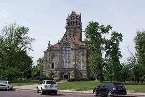 Starke County courthouse in Knox | |
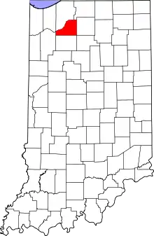 Location within the U.S. state of Indiana | |
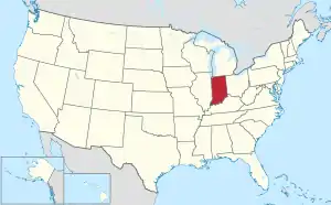 Indiana's location within the U.S. | |
| Coordinates: 41°16′N 86°39′W | |
| Country | |
| State | |
| Founded | 7 February 1835 (authorized) 1850 (organized) |
| Named for | General John Stark |
| Seat | Knox |
| Largest city | Knox |
| Area | |
| • Total | 312.21 sq mi (808.6 km2) |
| • Land | 309.13 sq mi (800.6 km2) |
| • Water | 3.07 sq mi (8.0 km2) 0.98%% |
| Population | |
| • Estimate (2018) | 22,935 |
| • Density | 74.2/sq mi (28.6/km2) |
| Time zone | UTC−5 (Eastern) |
| • Summer (DST) | UTC−4 (EDT) |
| Congressional district | 2nd |
| Website | www |
| Indiana county number 75 | |
History
The Indiana State Legislature passed an omnibus county bill[3] on 7 February 1835 that authorized the creation of thirteen counties in northeast Indiana, including Starke.[4] The county government organization commenced in 1850.[5] It was named for Gen. John Stark,[6] who commanded New Hampshire troops at the Battle of Bunker Hill in 1775 in the American Revolutionary War, and who defeated the British at the Battle of Bennington in 1777.[7]
Before white settlement, all of the land that forms modern-day Starke County and adjacent LaPorte County to the north was inhabited by the Potawatami Indian nation. These groups were forcibly removed to Kansas by the United States government in 1838, and many died on what has been called the Potawatomi Trail of Death.[8][9]
When Starke County was created, it included the present LaPorte County townships of Cass, Dewey, Hanna, and Prairie. It was necessary for residents in this area to travel some distance east to Lemon's Bridge to cross the Kankakee River in order to travel south to the center of the county, the future site of the county seat at Knox. Therefore, because they were effectively isolated from the rest of Starke county, residents north of the river petitioned to be annexed to LaPorte county and this was done on January 28, 1842.[10]
Name
Despite being named for General John Stark and originally being known and appearing on maps as Stark County[11] when initially created and organized, an e was added to the county's name fairly early in its history. There does not seem to be any solid evidence to clearly explain this alteration. Three possible explanations have been advanced: an early scribe had 'fancy lettering', including a k with a long tail or flourish that appeared to others as ke, the new spelling sticking;[12] General Stark himself may have used a similar flourish at the end of his signature;[13] which became a point of confusion to Indiana officials (This seems unlikely, since Stark County in Ohio (1808) and Illinois (1839) both preceded Starke County, Indiana and offered clear precedence and guidance on the spelling of the name, not to mention other numerous settlements within the United States named after the General also preceding Starke County.); it is thought that the change occurred around 1860 as the result of a clerical error by an official in Indianapolis.[14]
Geography
Starke County consists of low rolling hills covered with vegetation or brush.[15] Its boundaries include three prominences that rise to 780' (238m) ASL: two adjacent swells 0.6 mile (1.0 km) NE of Bass Lake, and a small ridge 3.0 miles (4.8 km) ESE of Bass Lake.[16]
According to the 2010 census, Starke County has a total area of 312.21 square miles (808.6 km2), of which 309.13 square miles (800.6 km2) (or 99.01%) is land and 3.07 square miles (8.0 km2) (or 0.98%) is water.[17] The northwestern boundary of Starke County is defined by the Kankakee River; the Yellow River, a tributary of the Kankakee, flows through the central part of the county, past Knox.[18]
Major highways
Adjacent counties
- LaPorte County - north
- St. Joseph County - northeast
- Marshall County - east
- Fulton County - southeast
- Pulaski County - south
- Jasper County - west
- Porter County - northwest
Municipalities
The municipalities in Starke County, and their populations as of the 2010 Census, are:
Cities and towns
- Hamlet – 800
- Knox – 3,704
- North Judson – 1,772
Census-designated places
- Bass Lake – 1,249
- Koontz Lake – 1,554
- San Pierre – 156
Unincorporated communities
Townships
The nine townships of Starke County, with their populations as of the 2010 Census, are:
- California – 2,011
- Center – 6,229
- Davis – 1,043
- Jackson – 549
- North Bend – 1,394
- Oregon – 3,367
- Railroad – 1,226
- Washington – 3,003
- Wayne – 4,541
Education
Public schools in Starke County are administered by four different districts:
Hospitals
- Indiana University Health Starke Hospital
Climate and weather
| Knox, Indiana | ||||||||||||||||||||||||||||||||||||||||||||||||||||||||||||
|---|---|---|---|---|---|---|---|---|---|---|---|---|---|---|---|---|---|---|---|---|---|---|---|---|---|---|---|---|---|---|---|---|---|---|---|---|---|---|---|---|---|---|---|---|---|---|---|---|---|---|---|---|---|---|---|---|---|---|---|---|
| Climate chart (explanation) | ||||||||||||||||||||||||||||||||||||||||||||||||||||||||||||
| ||||||||||||||||||||||||||||||||||||||||||||||||||||||||||||
| ||||||||||||||||||||||||||||||||||||||||||||||||||||||||||||
In recent years, average temperatures in Knox have ranged from a low of 14 °F (−10 °C) in January to a high of 84 °F (29 °C) in July, although a record low of −29 °F (−34 °C) was recorded in January 1985 and a record high of 102 °F (39 °C) was recorded in June 1988. Average monthly precipitation ranged from 1.68 inches (43 mm) in February to 4.09 inches (104 mm) in June.[23]
Government
The county government is a constitutional body, granted specific powers by the Constitution of Indiana and the Indiana Code.
County Council: The county council is the legislative branch of the county government and controls spending and revenue collection in the county. Representatives are elected from county districts to four-year terms. They are responsible for setting salaries, the annual budget, and special spending. The council has limited authority to impose local taxes, in the form of an income and property tax that is subject to state level approval, excise taxes, and service taxes.[24][25]
Board of Commissioners: The executive body of the county, the commissioners are elected county-wide to staggered four-year terms. One commissioner serves as president. The commissioners execute the acts legislated by the council, collect revenue, and manage the functions of the county government.[24][25]
Court: The judge on the court is elected to a term of six years. The judge is assisted by a magistrate who is appointed by the judge. The court handles criminal and civil cases, and has a small claims division. In some cases, court decisions can be appealed to the state level circuit court.[25]
County Officials: The county has other elected offices, including sheriff, coroner, auditor, treasurer, recorder, surveyor, and circuit court clerk, elected to four-year terms. Members elected to county government positions are required to declare party affiliations and to be residents of the county.[25]
Starke County is part of Indiana's 2nd congressional district in the United States House of Representatives; a district that has been represented by Jackie Walorski since January 2013.
| Year | Republican | Democratic | Third parties |
|---|---|---|---|
| 2020 | 72.6% 7,466 | 25.8% 2,650 | 1.7% 174 |
| 2016 | 68.3% 6,367 | 26.7% 2,489 | 4.9% 460 |
| 2012 | 54.0% 4,738 | 43.4% 3,809 | 2.5% 222 |
| 2008 | 47.2% 4,473 | 50.4% 4,778 | 2.4% 228 |
| 2004 | 54.2% 4,846 | 44.6% 3,987 | 1.2% 104 |
| 2000 | 50.0% 4,349 | 47.5% 4,136 | 2.5% 216 |
| 1996 | 38.1% 3,108 | 47.3% 3,854 | 14.6% 1,188 |
| 1992 | 35.4% 3,100 | 42.2% 3,695 | 22.4% 1,963 |
| 1988 | 51.8% 4,458 | 47.7% 4,104 | 0.5% 44 |
| 1984 | 57.4% 5,104 | 41.3% 3,674 | 1.3% 111 |
| 1980 | 55.3% 5,035 | 39.7% 3,615 | 5.1% 460 |
| 1976 | 47.1% 4,354 | 51.4% 4,753 | 1.5% 134 |
| 1972 | 64.4% 5,520 | 35.0% 2,994 | 0.6% 53 |
| 1968 | 48.0% 4,011 | 38.4% 3,208 | 13.7% 1,146 |
| 1964 | 41.7% 3,466 | 58.1% 4,838 | 0.2% 17 |
| 1960 | 53.3% 4,592 | 46.4% 3,995 | 0.4% 32 |
| 1956 | 59.9% 5,063 | 39.7% 3,349 | 0.4% 35 |
| 1952 | 59.4% 4,871 | 40.0% 3,274 | 0.6% 51 |
| 1948 | 50.6% 3,518 | 47.6% 3,312 | 1.9% 130 |
| 1944 | 55.7% 3,574 | 43.5% 2,791 | 0.8% 50 |
| 1940 | 54.2% 3,473 | 45.5% 2,917 | 0.3% 22 |
| 1936 | 47.2% 2,846 | 52.1% 3,143 | 0.7% 43 |
| 1932 | 40.8% 2,449 | 56.9% 3,420 | 2.4% 141 |
| 1928 | 57.3% 2,759 | 41.9% 2,016 | 0.8% 38 |
| 1924 | 53.0% 2,329 | 35.4% 1,555 | 11.6% 510 |
| 1920 | 62.9% 2,683 | 34.4% 1,467 | 2.7% 114 |
| 1916 | 52.2% 1,550 | 44.9% 1,334 | 2.9% 85 |
| 1912 | 28.1% 787 | 43.1% 1,208 | 28.8% 805 |
| 1908 | 52.2% 1,521 | 44.8% 1,305 | 3.1% 89 |
| 1904 | 54.5% 1,523 | 40.6% 1,134 | 5.0% 139 |
| 1900 | 49.6% 1,340 | 48.6% 1,315 | 1.8% 49 |
| 1896 | 51.0% 1,289 | 48.0% 1,214 | 1.0% 24 |
| 1892 | 44.3% 850 | 52.3% 1,003 | 3.3% 64 |
| 1888 | 47.2% 834 | 51.2% 904 | 1.6% 28 |
Demographics
| Historical population | |||
|---|---|---|---|
| Census | Pop. | %± | |
| 1840 | 149 | — | |
| 1850 | 557 | 273.8% | |
| 1860 | 2,195 | 294.1% | |
| 1870 | 3,888 | 77.1% | |
| 1880 | 5,105 | 31.3% | |
| 1890 | 7,339 | 43.8% | |
| 1900 | 10,431 | 42.1% | |
| 1910 | 10,567 | 1.3% | |
| 1920 | 10,278 | −2.7% | |
| 1930 | 10,620 | 3.3% | |
| 1940 | 12,258 | 15.4% | |
| 1950 | 15,282 | 24.7% | |
| 1960 | 17,911 | 17.2% | |
| 1970 | 19,280 | 7.6% | |
| 1980 | 21,997 | 14.1% | |
| 1990 | 22,747 | 3.4% | |
| 2000 | 23,556 | 3.6% | |
| 2010 | 23,363 | −0.8% | |
| 2018 (est.) | 22,935 | [27] | −1.8% |
| US Decennial Census[28] 1790-1960[29] 1900-1990[30] 1990-2000[31] 2010-2013[1] | |||
As of the 2010 United States Census, there were 23,363 people, 9,038 households, and 6,484 families in the county.[32] The population density was 75.6 inhabitants per square mile (29.2/km2). There were 10,962 housing units at an average density of 35.5 per square mile (13.7/km2).[17] The racial makeup of the county was 97.1% white, 0.3% American Indian, 0.3% black or African American, 0.2% Asian, 0.9% from other races, and 1.3% from two or more races. Those of Hispanic or Latino origin made up 3.3% of the population.[32] In terms of ancestry, 27.2% were German, 16.3% were Irish, 8.9% were English, 8.7% were American, and 6.9% were Polish.[33]
Of the 9,038 households, 32.7% had children under the age of 18 living with them, 54.2% were married couples living together, 11.7% had a female householder with no husband present, 28.3% were non-families, and 23.5% of all households were made up of individuals. The average household size was 2.58 and the average family size was 3.02. The median age was 40.4 years.[32]
The median income for a household in the county was $47,697 and the median income for a family was $44,044. Males had a median income of $37,507 versus $28,628 for females. The per capita income for the county was $17,991. About 12.9% of families and 15.7% of the population were below the poverty line, including 25.1% of those under age 18 and 7.0% of those age 65 or over.[34]
References
- "Starke County QuickFacts". US Census Bureau. Retrieved 25 September 2011.
- "Find a County". National Association of Counties. Retrieved 7 June 2011.
- John W Tyndall & OE Lesh, Standard history of Adams and Wells Counties, Indiana. pp. 284-6 (accessed 9 August 2020)
- The counties are Dekalb, Fulton, Jasper, Jay, Kosciusko, Marshall, Newton, Porter, Pulaski, Stark, Steuben, Wells, and Whitley. Newton County was merged with Jasper County in 1839, and was re-authorized as a separate county in 1859.
- "Starke County Historical Society. Retrieved 1 January 2010". Archived from the original on 16 July 2011. Retrieved 1 January 2010.
- Baker, Ronald L.; Marvin Carmony (1995). Indiana Place Names. Bloomington: Indiana University Press. p. 158. ISBN 0-253-28340-X.
- De Witt Clinton Goodrich & Charles Richard Tuttle (1875). An Illustrated History of the State of Indiana. Indiana: R. S. Peale & Co. p. 577.
- "Starke County Public Library factsheet" (PDF). scpl.lib.in.us. Archived from the original (PDF) on 24 June 2008.
- "History of 1838 Trail of Death". potawatomi-tda.org.
- Brief history of LaPorte county Archived 2008-05-17 at the Wayback Machine
- "Stark County, Indiana, 1857". dickinson.edu. Archived from the original on 9 July 2012.
- "Starke or Stark". www.starkehistory.com. Archived from the original on 17 May 2008. Retrieved 11 April 2018.
- "Archived copy". Archived from the original on 15 May 2008. Retrieved 16 January 2009.CS1 maint: archived copy as title (link)
- "Archived copy" (PDF). Archived from the original (PDF) on 25 March 2009. Retrieved 16 January 2009.CS1 maint: archived copy as title (link)
- Starke County IN (Google Maps - accessed 20 January 2020)
- Starke County High Point, Indiana (PeakBagger.com, accessed 20 January 2020)
- "Population, Housing Units, Area, and Density: 2010 - County". US Census Bureau. Archived from the original on 12 February 2020. Retrieved 10 July 2015.
- Indiana Atlas & Gazetteer. Yarmouth ME: DeLorme. 1998. pp. 19–20, 25–26. ISBN 0-89933-211-0.
- "Culver Community Schools - Welcome!". culver.k12.in.us.
- "Knox Community School Corporation". knox.k12.in.us.
- "North Judson-San Pierre Schools". North Judson-San Pierre Schools.
- "Oregon Davis". od.k12.in.us. Archived from the original on 16 May 2014. Retrieved 16 June 2014.
- "Monthly Averages for Knox IN". The Weather Channel. Retrieved 27 January 2011.
- Indiana Code. "Title 36, Article 2, Section 3". IN.gov. Retrieved 16 September 2008.
- Indiana Code. "Title 2, Article 10, Section 2" (PDF). IN.gov. Retrieved 16 September 2008.
- Leip, David. "Atlas of US Presidential Elections". uselectionatlas.org. Retrieved 11 April 2018.
- "Population and Housing Unit Estimates". Retrieved 26 July 2019.
- "US Decennial Census". US Census Bureau. Retrieved July 10, 2014.
- "Historical Census Browser". University of Virginia Library. Retrieved July 10, 2014.
- "Population of Counties by Decennial Census: 1900 to 1990". US Census Bureau. Retrieved July 10, 2014.
- "Census 2000 PHC-T-4. Ranking Tables for Counties: 1990 and 2000" (PDF). US Census Bureau. Retrieved July 10, 2014.
- "Profile of General Population and Housing Characteristics: 2010 Demographic Profile Data". US Census Bureau. Archived from the original on 13 February 2020. Retrieved 10 July 2015.
- "Selected Social Characteristics in the US – 2006-2010 American Community Survey 5-Year Estimates". US Census Bureau. Archived from the original on 14 February 2020. Retrieved 10 July 2015.
- "Selected Economic Characteristics – 2006-2010 American Community Survey 5-Year Estimates". US Census Bureau. Archived from the original on 14 February 2020. Retrieved 10 July 2015.
External links
![]() Media related to Starke County, Indiana at Wikimedia Commons
Media related to Starke County, Indiana at Wikimedia Commons
Places adjacent to Starke County, Indiana | ||||||||||
|---|---|---|---|---|---|---|---|---|---|---|
| ||||||||||
Municipalities and communities of Starke County, Indiana, United States | ||
|---|---|---|
| City | Map of Indiana highlighting Starke County | |
| Towns | ||
| Townships | ||
| CDPs | ||
| Other unincorporated communities | ||
| Footnotes | ‡This populated place also has portions in an adjacent county or counties | |
| ||

| Authority control |
|---|