Grade II* listed buildings in Cornwall (H–P)
There are over 20,000 Grade II* listed buildings in England. This article comprises a list of these buildings in the county of Cornwall.
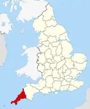
Cornwall shown in England
List of buildings
| Name | Location | Type | Completed [note 1] | Date designated | Grid ref.[note 2] Geo-coordinates |
Entry number [note 3] | Image |
|---|---|---|---|---|---|---|---|
| Halton Barton Farmhouse | St. Dominick | Farmhouse | Early 17th century | 21 July 1951 | SX4100665624 50°28′08″N 4°14′30″W |
1329382 |  |
| Harbour piers and quays | Mevagissey | Harbour | 1770–73 | 11 March 1974 | SX0165244796 50°16′11″N 4°47′05″W |
1210773 | 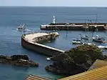 Harbour piers and quays |
| Harbour piers and quays including Inner Basin | Charlestown, St. Austell Bay | Harbour | 1801? | 11 March 1974 | SX0387751631 50°19′55″N 4°45′25″W |
1327290 | 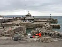 Harbour piers and quays including Inner Basin |
| Harbour piers and walls | Mousehole, Penzance | Harbour | 17th century | 29 July 1950 | SW4700126266 50°04′57″N 5°32′16″W |
1219071 | 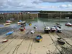 Harbour piers and walls |
| Harbour wharfs and piers including the two lighthouses (one disused) | St Ives | Harbour | 1767–70 | 4 June 1952 | SW5208840784 50°12′54″N 5°28′35″W |
1143383 | 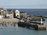 Harbour wharfs and piers including the two lighthouses (one disused) |
| Harlyn House | St. Merryn | House | 17th century | 25 October 1951 | SW8721175117 50°32′13″N 5°00′15″W |
1212748 |  Harlyn House |
| Hatt House | Botusfleming | House | Late 16th or early 17th century | 23 January 1968 | SX3974462344 50°26′20″N 4°15′29″W |
1140246 | |
| Helland Bridge | St Mabyn | Road bridge | c.Early 15th century | 4 November 1988 | SX0652071498 50°30′40″N 4°43′49″W |
1327947 |  Helland Bridge |
| Hennett | Hennett, St. Juliot | Farmhouse | Probably late 16th century | 17 December 1962 | SX1307391350 50°41′30″N 4°38′52″W |
1143463 | |
| Heskyn Mill and Chimney | St Germans | Corn mill | Early–mid-19th century | 9 October 1987 | SX3427159598 50°24′46″N 4°20′02″W |
1140571 |  Heskyn Mill and Chimney |
| Heyle (NAK Centre) | Helford Passage, Mawnan | House | 1914 | 17 June 1988 | SW7611226996 50°06′03″N 5°07′55″W |
1328411 | |
| High Hall Farmhouse | Laneast | Farmhouse | Late 16th/early 17th century | 1 December 1951 | SX2366085751 50°38′41″N 4°29′44″W |
1142793 | |
| Higher Lodge at Trematon Castle | Forder, Saltash | House | 1807–08 | 22 November 1982 | SX4102857960 50°24′00″N 4°14′18″W |
1140409 | |
| Higher Penrose | North Petherwin | Farmhouse | Early 17th century | 23 August 1957 | SX2574989151 50°40′33″N 4°28′03″W |
1160373 | |
| Higher Tresmorn | St Gennys | House | 16th century | 12 October 1984 | SX1614197704 50°44′59″N 4°36′28″W |
1137246 |  Higher Tresmorn |
| Hogus House | Ludgvan Churchtown, Ludgvan | House | c.Late 18th century | 16 January 1978 | SW5051232987 50°08′40″N 5°29′36″W |
1143604 | 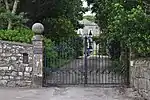 Hogus House |
| Holy Well about 7m south-east of Rialton Manor | Colan | Holy well | 15th century | 12 May 1988 | SW8477362225 50°25′13″N 5°01′52″W |
1137202 | |
| Holy Well of Saint Wendrona at SW676285 | Wendron | Holy well | Probably 15th century | 10 July 1957 | SW6768528475 50°06′39″N 5°15′02″W |
1142042 | |
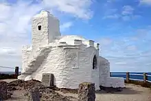
| Holy Well of St Clether | St Clether | Holy well | 15th century | 19 January 1952 | SX2023084591 50°38′00″N 4°32′36″W |
1159283 | 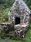 Holy Well of St Clether |
| House adjoining Church Cottage to the west | Stratton, Bude–Stratton | House | Late 15th/early 16th century | 5 March 1952 | SS2309206468 50°49′50″N 4°30′48″W |
1141878 | |
| Huer's House | Newquay | House | Probably late 18th/early 19th century | 24 October 1951 | SW8067262386 50°25′13″N 5°05′20″W |
1144136 | |
| Inscribed stone (Castle Dor Stone) [aka the Tristan Stone] | Fowey | Inscribed stone | c.550 AD | 13 March 1951 | SX1123152120 50°20′19″N 4°39′15″W)] |
1219027 |  Inscribed stone (Castle Dor Stone) [aka the Tristan Stone] |
| Keigwin and Little Keigwin | Mousehole, Penzance | Manor house | 16th century | 29 July 1950 | SW4689026266 50°04′57″N 5°32′22″W |
1143207 | 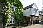 Keigwin and Little Keigwin |
| Kennal Vale House, including adjoining garden walls, gate piers and gates | Kennal Vale, Stithians | Country house | c.1830 | 17 June 1988 | SW7463037099 50°11′27″N 5°09′31″W |
1162099 | |
| Kerris Manor Farmhouse including front garden walls and rear courtyard walls | Kerris, Paul | Gate pier | 17th century | 15 December 1988 | SW4430727155 50°05′22″N 5°34′34″W |
1327506 | 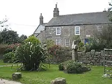 Kerris Manor Farmhouse including front garden walls and rear courtyard walls |
| Kestle | Egloshayle | House | c.Late 15th/early 16th century | 4 November 1988 | SX0163371770 50°30′43″N 4°47′57″W |
1143047 | |
| Kestle Barton Farmhouse and Kestle Cottage, including adjoining garden walls | Manaccan | Farmhouse | 17th century | 10 July 1957 | SW7534725469 50°05′12″N 5°08′31″W |
1141732 | |
| Keveral Barton | St Martin-by-Looe | House | c.16th century | 21 August 1964 | SX2975355168 50°22′18″N 4°23′44″W |
1329284 | |
| Killiow House | Kea | Country house | 18th century | 30 May 1967 | SW8046242138 50°14′18″N 5°04′48″W |
1329022 | |
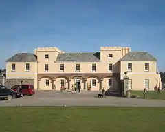
| King Charles's Castle | Tresco, Isles of Scilly | Castle | 1550–54 | 14 December 1992 | SV8825316115 49°57′49″N 6°20′55″W |
1328850 | |
| Kitchen garden walls with gate piers about 30m south-west of Lanherne Carmelite Convent | St Mawgan, Mawgan-in-Pydar | Gate pier | Early 18th century | 12 May 1988 | SW8708365837 50°27′13″N 5°00′03″W |
1327382 | |
| Knill's Monument, Worvas | St. Ives | Commemorative monument | 1782 | 4 June 1952 | SW5163038668 50°11′45″N 5°28′53″W |
1143386 | 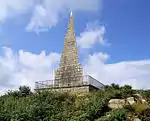 Knill's Monument, Worvas |
| Lamellen | St Tudy | House | 1849 | 4 November 1988 | SX0555477329 50°33′48″N 4°44′49″W |
1309875 | |
| Lancarffe | Lancarffe, Helland | House | Probably 17th century | 6 June 1969 | SX0825268948 50°29′20″N 4°42′16″W |
1146396 | |
| Lander's Monument | Truro | Statue | 1852 | 29 December 1950 | SW8235844400 50°15′34″N 5°03′17″W |
1282638 | .jpg.webp) Lander's Monument |
| Langford Hill | Marhamchurch | House | Early 18th century | 28 September 1961 | SS2367401334 50°47′05″N 4°30′10″W |
1328535 | |
| Lantau | East Looe, Looe | Jettied house | Late 16th/early 17th century | 19 March 1951 | SX2557853189 50°21′10″N 4°27′11″W |
1282823 | |
| Lantern cross about 7m north-west of Church of St Mawgan | St Mawgan, Mawgan-in-Pydar | Cross | 15th century | 12 December 1991 | SW8720865949 50°27′17″N 4°59′57″W |
1115117 | |
| Lanyon farmhouse, including front garden area wall | Gwinear–Gwithian | Farmhouse | 1668 | 14 January 1988 | SW6034237794 50°11′30″N 5°21′32″W |
1327594 | |
| Launcells Barton | Launcells | Farmhouse | c.1600 | 29 September 1961 | SS2448505749 50°49′29″N 4°29′36″W |
1328573 | |
| Launceston town walls | Launceston | Town wall | Probably 12th century | 13 September 1972 | SX3329584623 50°38′15″N 4°21′32″W |
1195978 | |
| Lavethan | Blisland | House | c.Early to mid-16th century | 6 June 1969 | SX0954473015 50°31′33″N 4°41′18″W |
1142391 | |
| Lawn House | Mevagissey | House | 18th century | 28 November 1950 | SX0131045101 50°16′21″N 4°47′23″W |
1210790 | |
| Lawrence House and Museum and forecourt wall | Launceston | Town house | 1753 | 27 February 1950 | SX3306084753 50°38′19″N 4°21′44″W |
1206174 | |
| Lead bust to south-east of Prideaux Place | Prideaux Place, Padstow | Bust | 18th century | 20 May 1988 | SW9139775538 50°32′32″N 4°56′44″W |
1212013 | |
| Leaze | St Breward | House | c.mid-17th century | 20 March 1985 | SX1332176858 50°33′42″N 4°38′14″W |
1327915 | |
| Leek Seed Chapel | St Blazey Gate, St. Blaise | Wesleyan Methodist chapel | 1824 | 14 April 1999 | SX0602153698 50°21′04″N 4°43′41″W |
1386524 | |
| Leigh Farmhouse | Week St Mary | Farmhouse | Late 16th/early 17th century | 17 June 1982 | SX2420098912 50°45′47″N 4°29′39″W |
1328250 | |
| Lerryn Bridge | Lerryn, St Veep | Bridge | Repaired 1573 | 21 August 1964 | SX1408757153 50°23′05″N 4°36′59″W |
1329264 | 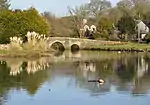 Lerryn Bridge |
| Levalsa Farmhouse | St Ewe | Farmhouse | c.Early 17th century | 15 November 1988 | SW9996948580 50°18′11″N 4°48′37″W |
1136796 | 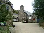 Levalsa Farmhouse |
| Little Tregrill and outbuildings adjoining to south-west | Menheniot | House | Late 16th century | 26 November 1985 | SX2821663100 50°26′33″N 4°25′14″W |
1312676 | |
| Little Trethewey Wesleyan Chapel | Little Trethewey, St Levan | Wesleyan Methodist chapel | 1868 | 15 December 1988 | SW3797523807 50°03′24″N 5°39′44″W |
1311918 | |
| Long Stone | St Austell | Standing stone | Bronze Age | 11 March 1974 | SX0295952119 50°20′09″N 4°46′13″W |
1212080 | |
| Lower Hampt including attached wall and archway | Stokeclimsland | Farmhouse | Late 16th century | 22 November 1960 | SX3960174203 50°32′44″N 4°15′55″W |
1220204 | |
| Lower Trekenner Farmhouse and Cottage | Trekenner, Lezant | House | Early 17th century | 11 May 1989 | SX3423578294 50°34′51″N 4°20′34″W |
1291321 | |
| Lower Truscott | St Stephens by Launceston Rural | House | Early 17th century | 11 January 1989 | SX3019485969 50°38′55″N 4°24′12″W |
1327997 | 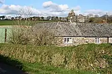 Lower Truscott |
| Lowerton House | Landrake, Landrake with St. Erney | Farmhouse | Probably late 16th/early 17th century | 23 January 1968 | SX3760360632 50°25′23″N 4°17′15″W |
1140565 | |
| Lychgate and adjoining churchyard walls south of Church of St Gwendron | Wendron | Lych gate | Probably late 18th century | 10 July 1957 | SW6787731029 50°08′02″N 5°14′58″W |
1162651 | 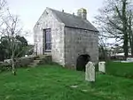 Lychgate and adjoining churchyard walls south of Church of St Gwendron |
| No. 26 Church Street | Launceston | Apartment | 17th century | 27 February 1950 | SX3319684600 50°38′14″N 4°21′37″W |
1206285 | 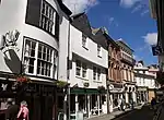 No. 26 Church Street |
| No. 11, 13 and 13A High Street and 12 Broad Street | Launceston | House | 18th century | 27 February 1950 | SX3317084586 50°38′13″N 4°21′38″W |
1206510 | |
| No. 5 Castle Street | Launceston | House | Early 18th century | 13 September 1972 | SX3305184722 50°38′18″N 4°21′44″W |
1280379 | |
| No. 5 and 7 Southgate Street | Launceston | House | 18th century | 27 February 1950 | SX3323684570 50°38′13″N 4°21′35″W |
1196027 | |
| No. 8 and 9 Quay Street | Lostwithiel | House | Early–mid-18th century | 21 April 1976 | SX1047159707 50°24′24″N 4°40′07″W |
1146531 | |
| No. 27 Polkirt Hill | Mevagissey | House | Early 18th century | 28 November 1950 | SX0151044679 50°16′07″N 4°47′12″W |
1289977 | |
| No. 3 Chapel Street | Penzance | House | 18th century | 29 July 1950 | SW4737830152 50°07′03″N 5°32′07″W |
1220707 | |
| No. 51 High Street | Falmouth | Merchants house | Late 17th century | 23 January 1973 | SW8063133138 50°09′27″N 5°04′21″W |
1270039 | |
| No. 27 and 29 Fore Street | Fowey | House | Early 17th century | 13 March 1951 | SX1261951777 50°20′10″N 4°38′04″W |
1144272 | 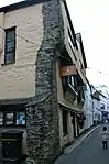 No. 27 and 29 Fore Street |
| No. 54 and 55 Church Street | Falmouth | Shop | Early 19th century | 22 July 1949 | SW8091532793 50°09′17″N 5°04′06″W |
1270078 | |
| No. 1–3 Bank Place | Falmouth | Terrace | c.1770s | 22 July 1949 | SW8112232455 50°09′06″N 5°03′55″W |
1270126 | 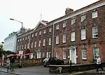 No. 1–3 Bank Place |
| No. 48 Arwenack Street | Falmouth | Town house | c.1770s | 22 July 1949 | SW8109232491 50°09′07″N 5°03′57″W |
1270121 | 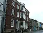 No. 48 Arwenack Street |
| Manning chest tomb about 17m south of the chancel of the Church of St Morwenna | Morwenstow | Chest tomb | Early 17th century | 9 September 1985 | SS2051415288 50°54′33″N 4°33′16″W |
1328565 | |
| Manor Farm | Camelford | House | Possibly late 16th century | 17 December 1962 | SX1069083848 50°37′25″N 4°40′40″W |
1143562 | 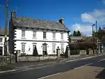 Manor Farm |
| Manor Houses | Grampound, Grampound with Creed | House | Probably 16th/early 17th century | 10 February 1967 | SW9361548268 50°17′53″N 4°53′57″W |
1327435 |  Manor Houses |
| Mansion House | Blisland | House | c.Late 16th century or earlier | 6 June 1969 | SX1007573220 50°31′40″N 4°40′52″W |
1311659 | 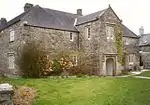 Mansion House |
| Marhayes Manor, including garden area wall adjoining at north-east and running parallel to north front | Week St Mary | Farmhouse | c.Early 17th century | 29 September 1961 | SS2419000818 50°46′49″N 4°29′43″W |
1137624 | |
| Market House | St Austell | Market house | 1844 | 11 March 1974 | SX0139252504 50°20′20″N 4°47′33″W |
1289697 | |
| Marlborough House | Falmouth | Country house | c.1810 | 23 January 1973 | SW7994531956 50°08′48″N 5°04′53″W |
1270002 | |
| Marsland Manor | Marsland Manor, Morwenstow | Farmhouse | 16th century origins | 26 September 1951 | SS2168716760 50°55′22″N 4°32′18″W |
1328542 |  Marsland Manor |
| Maryfield House | Maryfield, Antony | House | c.1849 | 26 January 1987 | SX4235656196 50°23′04″N 4°13′08″W |
1159513 | |
| Mausoleum of Sir James Tillie, Mount Ararat | Mount Ararat, Pillaton | Mausoleum | Early 18th century | 23 January 1968 | SX4067865121 50°27′51″N 4°14′46″W |
1329359 | 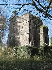 Mausoleum of Sir James Tillie, Mount Ararat |
| Medros Farmhouse and Methrose Farmhouse | Luxulyan | Farmhouse | c.1400 | 7 January 1952 | SX0506556312 50°22′28″N 4°44′34″W |
1144215 | |
| Meledor Farmhouse | St Stephen-in-Brannel | Farmhouse | Late 16th/early 17th century | 7 January 1952 | SW9273454833 50°21′25″N 4°54′55″W |
1327463 | |
| Menabilly House | Menabilly, Fowey | House | c.1710–15 | 13 March 1951 | SX1002751171 50°19′47″N 4°40′14″W |
1210574 | |
| Menacuddle Baptistery Church | St Austell, Treverbyn | Baptistery | 15th century | 28 November 1950 | SX0118953255 50°20′44″N 4°47′44″W |
1289730 | |
| Merthen Manor | Merthen, Constantine | Cross-passage house | 1575 | 10 July 1957 | SW7271326411 50°05′39″N 5°10′45″W |
1142128 | |
| Methodist Chapel | Gwithian Churchtown, Gwinear–Gwithian | Methodist chapel | c.1810 | 14 January 1988 | SW5863141166 50°13′16″N 5°23′06″W |
1159592 | |
| Methodist Chapel | Penrose, St Ervan | Methodist chapel | 1861 | 20 May 1988 | SW8753970763 50°29′53″N 4°59′50″W |
1212478 | |
| Methodist Church (former Wesleyan Chapel) and attached vestry | St. Just | Wesleyan Methodist chapel | 1833 | 21 September 1973 | SW3690731570 50°07′33″N 5°40′56″W |
1143291 | 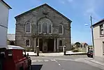 Methodist Church (former Wesleyan Chapel) and attached vestry |
| Methodist Church and forecourt wall, railings and gateway | Porthleven | Chapel | 1883 | 22 May 1990 | SW6296425923 50°05′10″N 5°18′54″W |
1208344 |  Methodist Church and forecourt wall, railings and gateway |
| Methodist Church including railings | Chapel St, Penzance | Methodist chapel | Mid-19th century | 7 February 1974 | SW4738330092 50°07′01″N 5°32′06″W |
1143151 | 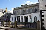 Methodist Church including railings |
| Milltown House and garden walls to front | Yeolmbridge, Werrington | House | Early 18th century | 11 January 1989 | SX3161687431 50°39′44″N 4°23′02″W |
1142820 | |
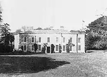
| Moditonham House | Botusfleming | House | Early 18th century | 23 January 1968 | SX4134461283 50°25′48″N 4°14′07″W |
1140248 | _p1.168_-_Moditonham_House%252C_Cornwall.jpg.webp) Moditonham House |
| Monument to H M Grylls | Helston | Gate | 1834 | 22 May 1972 | SW6569927410 50°06′02″N 5°16′40″W |
1196470 | 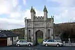 Monument to H M Grylls |
| Mr Lanyon's Almhouses and walls Surrounding Garden to East | Playing Place, Kea | Almshouses | 1726 | 30 May 1967 | SW8133741330 50°13′53″N 5°04′02″W |
1141647 | 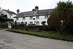 Mr Lanyon's Almhouses and walls Surrounding Garden to East |
| Murdoch House | Redruth | House | Late 18th century | 1 December 1951 | SW6981241961 50°13′58″N 5°13′45″W |
1161666 | 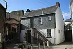 Murdoch House |
| Nance Farmhouse | Churchtown, Illogan | Dower house | Earlier 18th century and earlier | 1 December 1951 | SW6693644321 50°15′10″N 5°16′15″W |
1328148 | |
| Nancealverne House | Penzance | House | 18th century | 29 July 1950 | SW4612630776 50°07′21″N 5°33′11″W |
1291315 | |
| Napheane Farmhouse | Constantine | Farmhouse | Mid-17th century | 17 June 1988 | SW7147328428 50°06′43″N 5°11′52″W |
1328396 | |
| New Hall Farmhouse | Advent | Farmhouse | c.Late 16th century or earlier | 13 January 1988 | SX1094980428 50°35′34″N 4°40′21″W |
1137654 | |
| New Pattern Shop | Perran Wharf, Mylor | Pattern shop | c.Early 19th century | 30 May 1967 | SW7768138490 50°12′16″N 5°07′01″W |
1328668 | |
| Newbridge | Newbridge, Callington | Bridge | Mentioned 1478 | 23 January 1968 | SX3473767991 50°29′18″N 4°19′52″W |
1140043 | 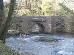 Newbridge |
| Newman House | Hugh Town, St. Mary's, Isles of Scilly | House | 1716–18 | 12 February 1975 | SV8990410788 49°55′00″N 6°19′17″W |
1328846 | 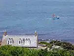 Newman House |
| No 1, Cross St, with attached forecourt and garden walls | Helston | Town house | Early 18th century | 24 March 1950 | SW6583527674 50°06′10″N 5°16′33″W |
1196306 | 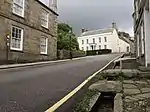 No 1, Cross St, with attached forecourt and garden walls |
| No 4, Cross St and attached forecourt walls, steps and railings | Helston | House | 1790s | 24 March 1950 | SW6574127576 50°06′07″N 5°16′38″W |
1297696 | |
| No 4, High St incorporating the Judge's Kitchen | Launceston | Jettied house | 16th/early 17th century | 27 February 1950 | SX3317684628 50°38′15″N 4°21′38″W |
1195985 | |
| No 58, Coinagehall St and attached walls | Helston | Town house | Early/mid-18th century | 22 May 1972 | SW6572227394 50°06′01″N 5°16′39″W |
1196302 | |
| Offices | Perran Wharf, Mylor | Iron foundry | c.Early/mid-19th century | 30 May 1967 | SW7759438449 50°12′15″N 5°07′05″W |
1141602 | |
| Ogbeare Hall | North Tamerton | House | 15th century | 29 September 1961 | SX3017295936 50°44′17″N 4°24′29″W |
1137225 | |
| Old Mansion House | Truro | Town house | c.1706–08 | 29 December 1950 | SW8282944775 50°15′47″N 5°02′54″W |
1206030 | 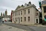 Old Mansion House |
| Open fronted outbuilding about 2m south-east of Radford Farmhouse | Werrington | Pump | 19th century | 11 February 1988 | SX3182188995 50°40′35″N 4°22′54″W |
1309930 | |
| Orangery in the Italian Garden | Mount Edgcumbe Country Park, Maker-with-Rame | Orangery | Late 18th century | 21 July 1951 | SX4547153274 50°21′33″N 4°10′26″W |
1329142 | 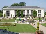 Orangery in the Italian Garden |
| Orangery with urn about 12m north and busts arranged to south, Port Eliot | St Germans | Orangery | c.1790 | 23 January 1968 | SX3604357690 50°23′46″N 4°18′29″W |
1140517 | 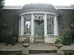 Orangery with urn about 12m north and busts arranged to south, Port Eliot |
| Outbuildings and adjoining walls about 30m north-west of Pengersick Castle | Breage | Gate lodge | Early 16th century | 26 August 1987 | SW5815328441 50°06′24″N 5°23′01″W |
1142231 | |
| Pair of gate piers and gate about 125m south-east of Trewardreva House | Trewardreva, Constantine | Gate | Late 19th century | 10 July 1957 | SW7270930070 50°07′37″N 5°10′53″W |
1142139 | |
| Pair of lodges with attached walls at the north entrance to Lanhydrock Park | Lanhydrock Park, Lanhydrock | Gate | Probably late 18th century | 15 April 1988 | SX0883964621 50°27′01″N 4°41′39″W |
1143096 | |
| Palace Printers and the Old Palace | Lostwithiel | Shop | Late 13th century | 21 April 1976 | SX1046759688 50°24′23″N 4°40′07″W |
1146471 | 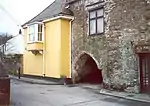 Palace Printers and the Old Palace |
| Panter's Bridge | Warleggan | Bridge | 15th century | 21 August 1964 | SX1589868026 50°28′59″N 4°35′47″W |
1329216 | 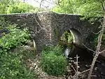 Panter's Bridge |
| Parc Venton | Mullion | House | c.1820s | 9 October 1984 | SW6759518568 50°01′19″N 5°14′45″W |
1158165 | |
| Parish Church of St Martin | Liskeard | Church | Mostly 15th century | 23 September 1950 | SX2540564405 50°27′12″N 4°27′39″W |
1206300 | .jpg.webp) Parish Church of St Martin |
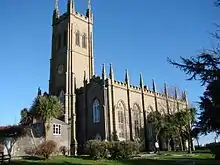
| Parish Church of St Mary | Penzance | Parish church | 1832–35 | 29 July 1950 | SW4752830027 50°06′59″N 5°31′59″W |
1220507 | |
| Parkandillick Engine House | Parkandillick China Clay Works, St Dennis | Boiler house | 19th century | 12 May 1988 | SW9480256827 50°22′32″N 4°53′14″W |
1138336 | 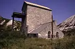 Parkandillick Engine House |
| Pavilion to Wearde Farmhouse | Saltash | Country house | Mid-18th century | 22 November 1982 | SX4214058145 50°24′07″N 4°13′22″W |
1140349 | 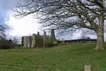 Pavilion to Wearde Farmhouse |
| Pelyn | Lostwithiel | House | c.1600 | 28 August 1987 | SX0912358804 50°23′53″N 4°41′13″W |
1137864 | |
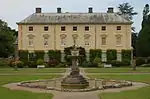
| Pencarrow House | Egloshayle | Country house | Late 17th or early 18th century | 4 November 1988 | SX0397371056 50°30′23″N 4°45′57″W |
1311084 | |
| Penelewey Barton Farmhouse and garden walls to South | Kea | Farmhouse | 1710 | 12 March 1986 | SW8184540867 50°13′39″N 5°03′36″W |
1159515 | |
| Penfound Manor | Poundstock | Cross-passage house | 15th century or earlier | 26 September 1951 | SX2209899731 50°46′11″N 4°31′28″W |
1328570 | |
| Pengenna | St Kew | House | 16th or earlier 17th century | 6 June 1969 | SX0503478652 50°34′30″N 4°45′18″W |
1320619 | |
| Pengover Manor Farmhouse | Menheniot | Farmhouse | Late 16th or early 17th century | 23 January 1985 | SX2810465272 50°27′43″N 4°25′24″W |
1329410 | |
| Penhaligon House, Prince's Street front | Truro | Town house | Early 18th century | 29 December 1950 | SW8279144775 50°15′46″N 5°02′56″W |
1205930 | |
| Penkivel Farmhouse at OS ref 867410 | Tregothnan Park, St. Michael Penkevil | Manor house | 16th/17th century | 28 February 1982 | SW8672141024 50°13′50″N 4°59′31″W |
1218978 | |
| Penmellyn | St Columb Major | House | c.1855 | 3 March 1987 | SW9141763785 50°26′12″N 4°56′19″W |
1327399 | |
| Pennans Farmhouse | Grampound with Creed | Farmhouse | c.1680 | 7 January 1952 | SW9546048967 50°18′18″N 4°52′25″W |
1144033 | |
| Pennellick Farmhouse | Pelynt | Farmhouse | Late 14th century | 26 March 1986 | SX2041553409 50°21′11″N 4°31′33″W |
1140728 | |
| Penrice | High Porthpean, Pentewan Valley | Country house | Mid-18th century | 11 March 1974 | SX0219649884 50°18′56″N 4°46′47″W |
1211821 | |
| Penrose Manor House | Porthleven | Country house | 17th century | 24 March 1950 | SW6412525775 50°05′07″N 5°17′55″W |
1196347 | 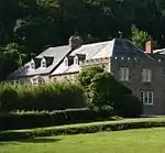 Penrose Manor House |
| Pentillie Castle | Pillaton | Country house | Late 17th century | 21 July 1951 | SX4099864557 50°27′33″N 4°14′29″W |
1140189 | |
| Penwarne House | Penwarne, Mawnan | Country house | Late 18th century | 10 July 1957 | SW7736430270 50°07′50″N 5°06′59″W |
1142101 | |
| Pillwood House | Feock, Truro | Holiday house | 1974 | 2 August 2017 | SW8259338639 50°12′28″N 5°02′54″W |
1449048 | |
| Polgover | Morval | House | c.17th century | 21 August 1964 | SX2763158908 50°24′17″N 4°25′37″W |
1137947 | |
| Polhawn Fort | Maker-with-Rame | House | 1865 | 19 November 1986 | SX4205449224 50°19′18″N 4°13′12″W |
1310634 | |
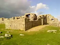
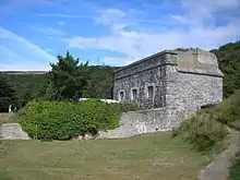
| Polruan Castle | Polruan, Lanteglos | Blockhouse | c.1540 | 21 August 1964 | SX1233651085 50°19′47″N 4°38′17″W |
1329297 | 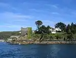 Polruan Castle |
| Polwheveral Bridge | Polwheveral, Constantine | Road bridge | 1572 | 17 June 1988 | SW7371028449 50°06′46″N 5°09′59″W |
1142132 | |
| Polytechnic Hall | Falmouth | Lending library | 1834–35 | 22 July 1949 | SW8091232686 50°09′13″N 5°04′06″W |
1270107 | 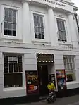 Polytechnic Hall |
| Ponsanooth Methodist Church, including forecourt walls, steps and gate piers | Ponsanooth, St. Gluvias | Chapel | 1843 | 28 June 1963 | SW7576837635 50°11′46″N 5°08′35″W |
1159101 | 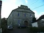 Ponsanooth Methodist Church, including forecourt walls, steps and gate piers |
| Porloe Farmhouse | Mylor | Farmhouse | c.mid-18th century | 12 March 1986 | SW8158335048 50°10′30″N 5°03′37″W |
1310625 | |
| Porth-en-alls | Prussia Cove, St. Hilary | House | 1906 | 9 October 1987 | SW5583727953 50°06′05″N 5°24′56″W |
1161301 | 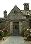 Porth-en-alls |
| Porth-en-alls Lodge | Prussia Cove, St. Hilary | Lodge | c.1910–14 | 9 October 1987 | SW5582127942 50°06′05″N 5°24′57″W |
1143755 | |
| Porthmeor Pilchard Cellars and Studios | St Ives | Fish cellar | Mid-19th century | 2 June 2004 | SW5178940868 50°12′56″N 5°28′50″W |
1390857 | |
| Princes House | Truro | Town house | c.1740 | 29 December 1950 | SW8277244778 50°15′47″N 5°02′57″W |
1282621 |  Princes House |
| Pump Engine House at Taylor's Shaft of New East Pool Mine | Pool, Carn Brea | Engine house | 1924 | 9 April 1975 | SW6741641881 50°13′52″N 5°15′45″W |
1142600 | 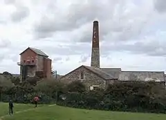 Pump Engine House at Taylor's Shaft of New East Pool Mine |
| Pump Engine House to Robinson's Shaft at South Crofty Mine | Carn Brea | Tin mine | 1903 | 12 September 1989 | SW6679641244 50°13′30″N 5°16′15″W |
1142628 | 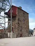 Pump Engine House to Robinson's Shaft at South Crofty Mine |
See also
Notes
- The date given is the date used by Historic England as significant for the initial building or that of an important part in the structure's description.
- Sometimes known as OSGB36, the grid reference is based on the British national grid reference system used by the Ordnance Survey.
- The "List Entry Number" is a unique number assigned to each listed building and scheduled monument by Historic England.
External links
![]() Media related to Grade II* listed buildings in Cornwall at Wikimedia Commons
Media related to Grade II* listed buildings in Cornwall at Wikimedia Commons
This article is issued from Wikipedia. The text is licensed under Creative Commons - Attribution - Sharealike. Additional terms may apply for the media files.