Hesdin-l'Abbé
Hesdin-l’Abbé is a commune in the Pas-de-Calais department in the Hauts-de-France region of France.
Hesdin-l’Abbé | |
|---|---|
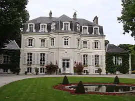 The chateau of Cléry, in Hesdin-l'Abbé | |
 Coat of arms | |
Location of Hesdin-l’Abbé 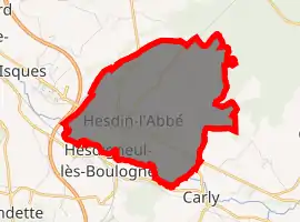
| |
 Hesdin-l’Abbé  Hesdin-l’Abbé | |
| Coordinates: 50°40′10″N 1°40′55″E | |
| Country | France |
| Region | Hauts-de-France |
| Department | Pas-de-Calais |
| Arrondissement | Boulogne-sur-Mer |
| Canton | Outreau |
| Intercommunality | Communauté d'agglomération du Boulonnais |
| Government | |
| • Mayor (2008–2014) | Jacques Pochet |
| Area 1 | 7.39 km2 (2.85 sq mi) |
| Population (2017-01-01)[1] | 1,863 |
| • Density | 250/km2 (650/sq mi) |
| Time zone | UTC+01:00 (CET) |
| • Summer (DST) | UTC+02:00 (CEST) |
| INSEE/Postal code | 62448 /62360 |
| Elevation | 7–130 m (23–427 ft) (avg. 11 m or 36 ft) |
| 1 French Land Register data, which excludes lakes, ponds, glaciers > 1 km2 (0.386 sq mi or 247 acres) and river estuaries. | |
Geography
A forestry and farming village situated some 5 miles (8.0 km) south of Boulogne, at the junction of the D901 (formerly the N1 Paris-Calais highway) and theD240 road. The A16 autoroute forms part of the western border of the commune and the river Liane the southern.
Population
| Year | 1962 | 1968 | 1975 | 1982 | 1990 | 1999 | 2006 |
|---|---|---|---|---|---|---|---|
| Population | 724 | 789 | 831 | 1396 | 1880 | 1998 | 1950 |
| From the year 1962 on: No double counting—residents of multiple communes (e.g. students and military personnel) are counted only once. | |||||||
Places of interest
- The church of St.Leger, dating from the seventeenth century.
- The eighteenth-century chateau d'Hesdin-l'Abbé, nowadays the Hotel Cléry.
- A seventeenth-century manorhouse.
References
- "Populations légales 2017". INSEE. Retrieved 6 January 2020.
| Wikimedia Commons has media related to Hesdin-l'Abbé. |
| Authority control |
|---|
This article is issued from Wikipedia. The text is licensed under Creative Commons - Attribution - Sharealike. Additional terms may apply for the media files.