Nesles
Nesles is a commune in the Pas-de-Calais department in the Hauts-de-France region of France.
Nesles | |
|---|---|
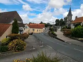 The town hall and church of Nesles | |
 Coat of arms | |
Location of Nesles 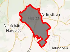
| |
 Nesles  Nesles | |
| Coordinates: 50°37′41″N 1°39′26″E | |
| Country | France |
| Region | Hauts-de-France |
| Department | Pas-de-Calais |
| Arrondissement | Boulogne-sur-Mer |
| Canton | Outreau |
| Intercommunality | Communauté d'agglomération du Boulonnais |
| Government | |
| • Mayor (2008–2014) | Guy Feutry |
| Area 1 | 5.04 km2 (1.95 sq mi) |
| Population | 953 |
| • Density | 190/km2 (490/sq mi) |
| Time zone | UTC+01:00 (CET) |
| • Summer (DST) | UTC+02:00 (CEST) |
| INSEE/Postal code | 62603 /62152 |
| Elevation | 21–177 m (69–581 ft) (avg. 38 m or 125 ft) |
| 1 French Land Register data, which excludes lakes, ponds, glaciers > 1 km2 (0.386 sq mi or 247 acres) and river estuaries. | |
Geography
Nesles is situated about 12 miles (19 km) south of Boulogne, at the junction of the D940 and D215 roads. The A16 autoroute straddles the middle of the commune's territory.
Population
| Year | Pop. | ±% p.a. |
|---|---|---|
| 1968 | 1,114 | — |
| 1975 | 977 | −1.86% |
| 1982 | 1,039 | +0.88% |
| 1990 | 1,097 | +0.68% |
| 1999 | 1,067 | −0.31% |
| 2007 | 1,047 | −0.24% |
| 2012 | 923 | −2.49% |
| 2017 | 953 | +0.64% |
| Source: INSEE[2] | ||
Places of interest
- The church of Notre-Dame, dating from the sixteenth century.
- The sixteenth century fortified manorhouse of la Haye.
- Mont Romain, a feudal motte with a moat.
References
- "Populations légales 2017". INSEE. Retrieved 6 January 2020.
- Population en historique depuis 1968, INSEE
| Wikimedia Commons has media related to Nesles. |
| Authority control |
|---|
This article is issued from Wikipedia. The text is licensed under Creative Commons - Attribution - Sharealike. Additional terms may apply for the media files.