Pernes-lès-Boulogne
Pernes-lès-Boulogne is a commune in the Pas-de-Calais department in the Hauts-de-France region of France.
Pernes-lès-Boulogne | |
|---|---|
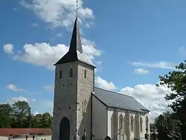 The church of Pernes-lès-Boulogne | |
 Coat of arms | |
Location of Pernes-lès-Boulogne 
| |
 Pernes-lès-Boulogne  Pernes-lès-Boulogne | |
| Coordinates: 50°45′09″N 1°42′13″E | |
| Country | France |
| Region | Hauts-de-France |
| Department | Pas-de-Calais |
| Arrondissement | Boulogne-sur-Mer |
| Canton | Boulogne-sur-Mer-1 |
| Intercommunality | Communauté d'agglomération du Boulonnais |
| Government | |
| • Mayor (2008–2014) | Jacques Berteloot |
| Area 1 | 7.76 km2 (3.00 sq mi) |
| Population (2017-01-01)[1] | 421 |
| • Density | 54/km2 (140/sq mi) |
| Time zone | UTC+01:00 (CET) |
| • Summer (DST) | UTC+02:00 (CEST) |
| INSEE/Postal code | 62653 /62126 |
| Elevation | 15–109 m (49–358 ft) (avg. 23 m or 75 ft) |
| 1 French Land Register data, which excludes lakes, ponds, glaciers > 1 km2 (0.386 sq mi or 247 acres) and river estuaries. | |
Geography
Pernes-lès-Boulogne is situated 5 miles (8.0 km) northeast of Boulogne, at the junction of the D233 and D233e roads.
Population
| Year | Pop. | ±% p.a. |
|---|---|---|
| 1968 | 345 | — |
| 1975 | 331 | −0.59% |
| 1982 | 412 | +3.18% |
| 1990 | 466 | +1.55% |
| 1999 | 423 | −1.07% |
| 2007 | 467 | +1.24% |
| 2012 | 464 | −0.13% |
| 2017 | 421 | −1.93% |
| Source: INSEE[2] | ||
Places of interest
- The church of St. Esprit, dating from the nineteenth century.
- The three 16th century manorhouses of Senlecque, Godincthun and Huplandre.
References
- "Populations légales 2017". INSEE. Retrieved 6 January 2020.
- Population en historique depuis 1968, INSEE
| Wikimedia Commons has media related to Pernes-lès-Boulogne. |
This article is issued from Wikipedia. The text is licensed under Creative Commons - Attribution - Sharealike. Additional terms may apply for the media files.