Vaulx-Vraucourt
Vaulx-Vraucourt is a commune in the Pas-de-Calais department in the Hauts-de-France region of France.
Vaulx-Vraucourt | |
|---|---|
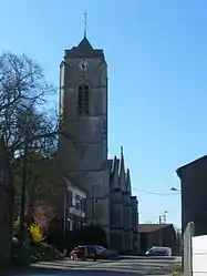 The church of Vaulx-Vraucourt | |
 Coat of arms | |
Location of Vaulx-Vraucourt 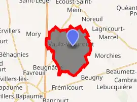
| |
 Vaulx-Vraucourt  Vaulx-Vraucourt | |
| Coordinates: 50°08′50″N 2°54′34″E | |
| Country | France |
| Region | Hauts-de-France |
| Department | Pas-de-Calais |
| Arrondissement | Arras |
| Canton | Bapaume |
| Intercommunality | CC Sud-Artois |
| Government | |
| • Mayor (2008–2014) | Christian Hémar |
| Area 1 | 14.11 km2 (5.45 sq mi) |
| Population (2017-01-01)[1] | 1,018 |
| • Density | 72/km2 (190/sq mi) |
| Time zone | UTC+01:00 (CET) |
| • Summer (DST) | UTC+02:00 (CEST) |
| INSEE/Postal code | 62839 /62159 |
| Elevation | 83–122 m (272–400 ft) (avg. 112 m or 367 ft) |
| 1 French Land Register data, which excludes lakes, ponds, glaciers > 1 km2 (0.386 sq mi or 247 acres) and river estuaries. | |
Geography
Vaulx-Vraucourt lies 15 miles (24.1 km) southeast of Arras and about 4 miles (6.4 km) northeast of Bapaume, at the junction of the D20, D10E and D36 roads.
History
The commune name comes from the two hamlets that were combined into one commune in 1821.
The village was the site of heavy fighting during World War I. Major battles occurred in this area in 1917 and 1918. Four military cemeteries are located in and around the village, containing the graves of soldiers from the United Kingdom, Canada, Australia, and New Zealand.
Population
| Year | 1962 | 1968 | 1975 | 1982 | 1990 | 1999 | 2006 |
|---|---|---|---|---|---|---|---|
| Population | 1040 | 1047 | 1021 | 1075 | 1133 | 1110 | 1072 |
| From the year 1962 on: No double counting—residents of multiple communes (e.g. students and military personnel) are counted only once. | |||||||
Places of interest
- The church of St.Martin, rebuilt, as was all of the village, after World War I
- The underground remains of an old chateau.
- A seventeenth century dovecote.
- The Commonwealth War Graves Commission cemeteries.
External links
| Wikimedia Commons has media related to Vaulx-Vraucourt. |
- Vaulx Hill CWGC cemetery
- Vaulx Hill CWGC cemetery
- Vaulx Australian CWGC cemetery
- Vraucourt Copse CWGC cemetery
- A website about Vaulx-Vraucourt (in French)
| Authority control |
|---|
This article is issued from Wikipedia. The text is licensed under Creative Commons - Attribution - Sharealike. Additional terms may apply for the media files.