Ruisseauville
Ruisseauville is a commune in the Pas-de-Calais department in the Hauts-de-France region of France.
Ruisseauville | |
|---|---|
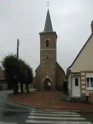 The church of Ruisseauville | |
 Coat of arms | |
Location of Ruisseauville 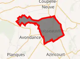
| |
 Ruisseauville  Ruisseauville | |
| Coordinates: 50°28′51″N 2°07′30″E | |
| Country | France |
| Region | Hauts-de-France |
| Department | Pas-de-Calais |
| Arrondissement | Montreuil |
| Canton | Fruges |
| Intercommunality | CC Haut Pays du Montreuillois |
| Government | |
| • Mayor (2020–2026) | Serge Pouthe |
| Area 1 | 3.89 km2 (1.50 sq mi) |
| Population (2017-01-01)[1] | 199 |
| • Density | 51/km2 (130/sq mi) |
| Time zone | UTC+01:00 (CET) |
| • Summer (DST) | UTC+02:00 (CEST) |
| INSEE/Postal code | 62726 /62310 |
| Elevation | 122–145 m (400–476 ft) (avg. 139 m or 456 ft) |
| 1 French Land Register data, which excludes lakes, ponds, glaciers > 1 km2 (0.386 sq mi or 247 acres) and river estuaries. | |
Geography
Ruisseauville lies 15 miles (24 km) east of Montreuil-sur-Mer, just to the south of Fruges, on the D928 road, and is typical of the region.
History
It was liberated in September 1944 by the Polish 1st Armoured Division[2]
Population
| Year | Pop. | ±% p.a. |
|---|---|---|
| 1968 | 142 | — |
| 1975 | 147 | +0.50% |
| 1982 | 148 | +0.10% |
| 1990 | 147 | −0.08% |
| 1999 | 121 | −2.14% |
| 2007 | 146 | +2.38% |
| 2012 | 180 | +4.28% |
| 2017 | 199 | +2.03% |
| Source: INSEE[3] | ||
Places of interest
- The church of St.Nicaise, dating from the seventeenth century
References
- "Populations légales 2017". INSEE. Retrieved 6 January 2020.
- WWII
- Population en historique depuis 1968, INSEE
| Wikimedia Commons has media related to Ruisseauville. |
| Authority control |
|---|
This article is issued from Wikipedia. The text is licensed under Creative Commons - Attribution - Sharealike. Additional terms may apply for the media files.